Traditional Syrian Architecture - CORPUS - Euromed Heritage
Traditional Syrian Architecture - CORPUS - Euromed Heritage
Traditional Syrian Architecture - CORPUS - Euromed Heritage

Create successful ePaper yourself
Turn your PDF publications into a flip-book with our unique Google optimized e-Paper software.
1<br />
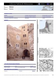
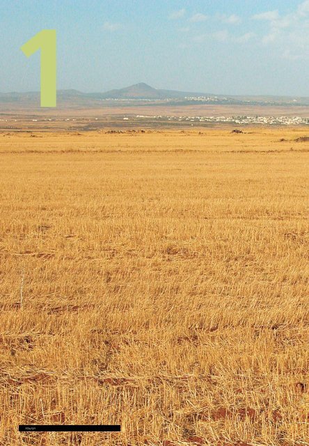
Hauran<br />
6
Territory and Habitat<br />
Physical Features<br />
Syria lies on the eastern coast of the Mediterranean Sea,<br />
bounded by Turkey in the north, Iraq in the east, Jordan in<br />
the south and Lebanon and the Mediterranean Sea in the<br />
west. The <strong>Syrian</strong> territory is divided into four geographical<br />
regions: coast, mountain, inside and desert regions, and<br />
administratively into 14 governorates that are divided into<br />
smaller local administrations; the village is the smallest<br />
administrative unit. Syria has 6 million hectares of cultivated<br />
lands; the remaining areas are desert and rocky mountains.<br />
The overall area of Syria is 185,180 km2 and the<br />
number of <strong>Syrian</strong> citizens registered at the end of 1999<br />
was 17,460,000 inhabitants. The average density of the<br />
population is about 87 inhabitants per km2 and the ratio<br />
of urban population out of the overall population is close<br />
to 50%.<br />
Syria enjoys the climate that generally prevails in<br />
Mediterranean regions; cold rainy winters and dry, hot<br />
summers, separated by two short transitional seasons.<br />
Heights above sea level vary from 10 m high in the City of<br />
Lattakia to 1,500 m above sea level in the city of Bloudan,<br />
near Damascus.<br />
The coastal region is characterized by heavy rainfall in<br />
winter, moderate temperatures and relatively high<br />
humidity in summer. The interior region is characterized by<br />
rainy winters, and hot and dry summer. The daily<br />
temperature differences, from maximum to minimum are<br />
high. The area in the mountains is 1,000 m high or more,<br />
it is characterized by rainy winters where rainfalls may<br />
exceed 1,000 mm and a moderate climate in summer. The<br />
desert region is characterized by small rainfalls in winter<br />
and hot and dry summers.<br />
Relief map of Syria<br />
7
Territory and Habitat<br />
People<br />
<strong>Syrian</strong> landscape view<br />
The great diversity of the <strong>Syrian</strong> landscape –hills, valleys,<br />
steppe and desert– have continuously sheltered a variety of<br />
peoples with different religions and languages: many<br />
civilizations and big empires have left their marks upon<br />
Syria. This diversity is both a result and a cause of its<br />
physical geographical aspects and its history. In some areas<br />
of Syria, Assyrians have kept their customs, lifestyles and<br />
original language. In Maaloula, for example, inhabitants<br />
still use Aramean, the language spoken by Jesus Christ.<br />
Arabs make up the overwhelming majority of the <strong>Syrian</strong><br />
population, though there are large minorities of different<br />
religions. The main language is, of course, Arabic, and the<br />
main faith is Islam.<br />
The architectural heritage obviously bears the testimony<br />
of this variety: for centuries, the country was a crossroad of<br />
great civilizations, each of which left its architectural and<br />
cultural influence. This naturally reflected on the<br />
architecture, habits and lifestyles of local populations.<br />
countryside of each governorate is then divided into<br />
regions. In the center of each region we find minor cities.<br />
A town must have a population of more than 20,000 to be<br />
considered a City and be allowed to administer its region.<br />
Smaller villages and farms are organized through smaller<br />
districts within each region.<br />
By the year 2000, a total of some 84 urban centers had<br />
a City status. In the early 70's, as the urban growth was<br />
registering its highest rates, Syria enforced a new Local<br />
Administration System. Cities elected City Councils to<br />
supervise their administration. Each Council has a small<br />
Executive Bureau to steer its work and this Bureau is<br />
headed by a Mayor. The Governorate level is administered<br />
by a similar system and has an elected Governorate<br />
Council. The Governor is appointed centrally and<br />
supervises the work of all government agencies in the<br />
governorate. Governorate Center-Cities have a greater<br />
level of autonomy and have a complete set of technical<br />
departments at their disposal. Smaller cities depend on the<br />
technical services provided on governorate level.<br />
The Ministry of Local Administration is in charge of<br />
coordinating and administering operations of the Local<br />
Administration Law. However, technical decisions related to<br />
urban planning, infrastructure and housing are coordinated<br />
with the Ministry of Housing. These two Ministries combined<br />
control over 10% of the national budget.<br />
Urban Organization<br />
Syria is administratively divided into 13 Governorates,<br />
and a special Governorate Status for the Capital City<br />
Damascus. Each governorate is organized around a major<br />
city known as the Governorate Center-City. The<br />
Damascus<br />
Arwad Island<br />
City revenues are constituted with locally collected fees<br />
and investments as well as a quota of national taxes<br />
(calculated on a per capita basis). Often, Central Government<br />
subsidies and grants are provided to finance large<br />
development projects. Specialized Ministry departments<br />
provide budgets for operations within their branch and for<br />
local projects in the governorates. All governmental budgets<br />
in Syria are submitted to approval on a national level.<br />
Between the City administration and the residents of<br />
the city, we find neighborhood committees and district<br />
clerks. The dialogue developed in these committees allows<br />
for an informal participation process. However, the true<br />
formal representation of residents is materialized in City<br />
Council elections, held every four years.<br />
8
Urban Phenomenon<br />
One of the major development trends is not limited to<br />
Syria but is a vast East Mediterranean trend: a mass ruralurban<br />
migration resulting in haphazard urban growth.<br />
Over the past century, the proportion of the world’s<br />
population living in large towns and cities has increased<br />
from 5 to 45%, and is expected to reach about twothirds<br />
by the year 2030. In Syria, the year 2000 estimate<br />
states that 54.5% of the <strong>Syrian</strong> population currently lives<br />
in urban areas and that the urbanization of Syria is<br />
increasing steadily.<br />
Territory and Habitat<br />
Oronte Valley<br />
or, on the other hand, to unplanned settlements and areas<br />
where housing doesn’t comply with current planning and<br />
building regulations. Because of the haphazard and<br />
frequently illegal nature of these settlements, their<br />
populations are often deprived of basic facilities and<br />
comfort, as well as access to basic services or social benefits.<br />
Aleppo<br />
Damascus growing<br />
Driven by economic factors and a great difference in<br />
living standards between rural and urban areas, waves of<br />
inhabitants migrate from rural areas, forming large<br />
uncontrolled settlements around major cities and urban<br />
centers. This phenomenon has reached an extent where the<br />
two major cities in Syria, Damascus and Aleppo, are now<br />
the home of about one third of the <strong>Syrian</strong> population.<br />
Uncontrolled settlements refer on the one hand to<br />
residential areas where groups of houses have been<br />
established illegally without any legal claim or right of land<br />
Hama<br />
The city of Aleppo appeared in history for the first time<br />
in the Acadian period, in the third millennium B.C. The<br />
Amorites settled in the area in the middle of the third<br />
millennium B.C. and established their kingdom (Yamhad).<br />
The Haitheen conquered the area and held it till 1600 B.C.,<br />
followed by the Egyptians, where it became a part of the<br />
Pharos’s Empire. The Assyrians ruled up to 612 B.C, and in<br />
539 B.C the Persians took over Aleppo. It was in this era<br />
that the name “Aleppo” was first mentioned: “Aleppo the<br />
son of Mahr”. During these times, the areas located south<br />
of the Old City were established.<br />
In 103 B.C. Aleppo was rebuilt in the Saluki's age and<br />
expanded to absorb the newcomers from Macedonia. The<br />
new areas were influenced by a Hellenistic style: all the<br />
streets were straight and orthogonal, facing the four<br />
cardinal points (chess board pattern) and the city walls<br />
were built parallel to the neighborhoods. In the 4th century<br />
(the Roman age), Aleppo became one of the major cities in<br />
the province of Khalstic. It fell under Byzantine rule in 330<br />
A.D. and further expanded to include new areas. The<br />
Muslims entered the city in 636 A.D. and the city walls and<br />
castle were fortified for defensive reasons. A few mosques<br />
were built in this period.<br />
The city stretched out further in the Umayyad era:<br />
khans, tkiyas and new mosques were built. The city was<br />
then attacked by the Crusades in 1100 A.D.: for defensive<br />
reasons, every neighborhood had its own markets and<br />
services and a gate on the main street leading to the<br />
neighborhood. The city flourished in the Hamdani era (the<br />
most famous ruler of that era was Saif Al Dawlah). In this<br />
era, the urban areas expanded and palaces were built. The<br />
walls were extended in the Ayubbid period and some new<br />
neighborhoods were established beyond the ramparts. The<br />
city continued to expand in the Mameluke era and<br />
residential areas surrounded the castle after it was<br />
destroyed by the Mongolians in 1258 A.D.<br />
9
Territory and Habitat<br />
In 1516 the Turkish leader Saliem the First entered the<br />
city, turning the city over to the Ottoman Empire. In this<br />
era, large construction projects transformed within the<br />
walls and beyond the walls, and the administrative system<br />
was changed. These innovations included a widening of the<br />
streets and the creation of the Al-Jadaideh district in the<br />
northern area beyond the city ramparts. This era also<br />
established new schools, new mosques, khans and<br />
markets. The city was boosted by energetic commercial<br />
development: caravans could find all the crops of the east<br />
in Aleppo, and the industrial sector flourished, becoming a<br />
center for raw materials and a market for European<br />
products.<br />
In the 17th and18th, centuries, many unofficial<br />
measures were taken, including local building procedures,<br />
resulting in the establishment of new construction<br />
techniques and new typologies.<br />
In the year 1832, the city fell in the hands of the<br />
Egyptians, but the Turks crossed the Euphrates again and<br />
regained the city. In the 19th century, the city developed a<br />
great deal, new streets were opened, the moat was filled<br />
and became a street, two and three storey buildings<br />
started appearing and dominated the architecture of that<br />
period, introducing a new architectural style, the<br />
traditional Arabic courtyard house. Squares and public<br />
gardens were made, rail roads and two train stations were<br />
established, new districts were planned and new directions<br />
were set for expansion, connecting with the Old City.<br />
The quick development of the city continued up to<br />
French occupation in 1920, the city urban planning was<br />
then set by French planners Dange and Ecochar. In this<br />
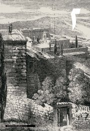
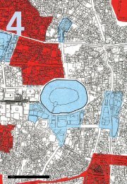
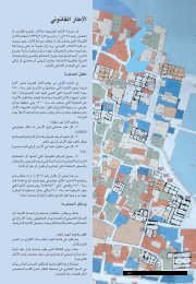
Old City of Aleppo in 1912 and urban map today<br />
period, wealthy people and foreigners lived in new areas<br />
where buildings were surrounded with gardens: move<br />
away from the traditional house and the situation of the<br />
higher classes in the areas had negative impact on the old<br />
city, and the differences between residents of the two<br />
areas became too blatantly obvious.<br />
After the independence of Syria, the French planner<br />
Gotten proposed a plan in 1954, suggesting a<br />
reorganization of the city by opening more streets. Some<br />
of these suggestions were implemented whilst others were<br />
canceled in the following master plan program drawn out<br />
by the Japanese planner Bashouba in 1974. As a result of<br />
these plans, some areas of the old city were destroyed to<br />
make way for the Bab al Faraj project (10 hectares).<br />
In 1986 the recommendations of UNESCO were taken<br />
into consideration and the Old City of Aleppo was listed as<br />
World <strong>Heritage</strong>.<br />
Damascus<br />
There is no text to tell the exact time of the first settlements<br />
in Damascus. However, there are clear indications to the<br />
emergence of the city, from the beginning of the eleventh<br />
century B.C. At that time, Damascus was an important city<br />
as it was the capital of the Aramaic kingdom. The castle,<br />
the kings' palace and the old temple were located on a plateau;<br />
it is hard to estimate the diameter of the original plateau<br />
that was in the very centre of the city, looking over<br />
the surrounding areas. The temple and the palace were the<br />
heart around which lived the urban community. There are<br />
manuscripts describing how water was channeled to the<br />
city in ancient times, using nearby canals.<br />
The city, according to documents and excavations, was<br />
not very different from the villages surrounding Damascus<br />
nowadays. It had no formal shape: the way in which the<br />
city was built was adapted to the nature of the landscape<br />
and the parameters of properties. Mud and wooden<br />
frameworks were used, exploiting a number of materials<br />
available locally.<br />
In the year 333 B.C the city was linked to the Greek<br />
expansion and joined Alexander's empire peacefully. After<br />
the death of Alexander, the city was given up to the<br />
Salukis: during this period it was rather similar to European<br />
cities though its location made it an oriental–Greek city.<br />
During this period, the city was renowned for its well<br />
proportioned building style and its organization. Houses<br />
were built in rectangular neighborhoods, identical in size,<br />
divided by straight streets.<br />
In later stages, the ties to Rome further enriched the city<br />
and Damascus flourished as it had never before thanks to<br />
the stability and peace that it enjoyed at that time. With<br />
time, the Roman colony of Damascus grew independent<br />
but maintained the organized form it inherited from the<br />
Greek age, introducing a main street with large, important<br />
buildings on each side of the street.<br />
That Arabs entered Damascus in the year 635 A.D.: in<br />
the beginning, the only signs of the new rule were the<br />
mosque and the khilafah house, that were built side by<br />
side in an empty sector of the city where the old temple<br />
used to stand. Later, the mosque was enlarged and<br />
became a token to the Greatness of the Umayyad period<br />
(and was named the Umayyad mosque).<br />
10
Territory and Habitat<br />
Damascus in the 19 th century<br />
After the downfall of the Umayyads, historical incidents<br />
increased as the Abbasids exhausted the city and its people<br />
with wars. These uncertain times continued until the<br />
Fatimid age. The appearance of the Seljuks put an end to<br />
troubled days of the city. The only development factor<br />
these periods brought to the city was triggered by the high<br />
level of insecurity: inhabitants had to look after themselves,<br />
gathering and organizing in groups. This transformed the<br />
city into a group of autonomous areas: each area had its<br />
own mosque and lived according to its own sort of<br />
lifestyle. Differences extended to the ways water systems,<br />
public baths and markets were organized (according to<br />
religions, tribes, and social groups…).<br />
It wasn’t long before each area had its own door,<br />
locked every evening, with smaller to smaller streets,<br />
leading to private houses.<br />
But there was a common denominator that brought<br />
these areas together into forming the larger city beyond its<br />
walls: the big mosque and the main market areas.<br />
In 1174 A.D. the Ayyubids controlled the city, their age<br />
was considered a real revival period for the city. The<br />
Ayyubids gave the city a strategic position from a military,<br />
cultural and religious point of view. They built the castle,<br />
the sultan's residence, on the northern western corner of<br />
the Roman wall, and surrounded it with government<br />
buildings. They also restored the city wall. The market areas<br />
grew, testifying to the economic growth of the city.<br />
Another important feature of this age was the tendency of<br />
religious sects to gather into specific quarters of the city:<br />
many bimarstans and schools emerged in this era.<br />
After the Mongolian conquest in 1260, Syria became<br />
part of Egypt under the rule of the Mamelukes. The military<br />
importance of the city played a big role in helping the trade<br />
sector flourish, encouraging the growth of markets that<br />
became increasingly specialized. Along with this industrial<br />
and commercial development, the need for labor increased<br />
and lead to an increase in population, calling for two new<br />
residential areas. The Mamelukes built a number of<br />
monuments that decorated the city. In the later stages of<br />
Mameluke ruling, the city deteriorated and suffered from<br />
poverty for many reasons. The city was in ruins when<br />
Sultan Saliem the Ottoman took over in 1516, but the<br />
vastness of the empire helped Damascus become once<br />
again a major trade area, especially because of its strategic<br />
location on the Hajj road. Khans and warehouses appeared<br />
and the Ottomans built large mosques that resembled the<br />
mosques in Istanbul (Constantine). At the end of this age,<br />
the city was influenced by European culture as a result of<br />
Muhammad Ali's conquering of Syria from 1832 to 1840.<br />
He built special health services, administrations, traffic<br />
organization facilities, and new markets.<br />
The French occupied Syria in 1921. In this era, the<br />
influence of European architecture was prominent and the<br />
expansion of the city was influenced by western urban<br />
planning and European building typologies. A new city was<br />
built beside the old city and beyond its traditional<br />
boundaries.<br />
Old City of Damascus in 1912 and aerial view today<br />
11