Deer Hunting - State of New Jersey
Deer Hunting - State of New Jersey
Deer Hunting - State of New Jersey
You also want an ePaper? Increase the reach of your titles
YUMPU automatically turns print PDFs into web optimized ePapers that Google loves.
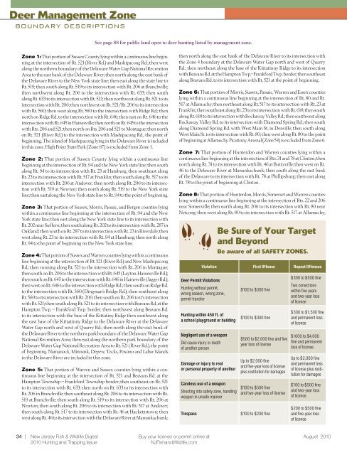
<strong>Deer</strong> Management Zone<br />
Boundary Descriptions<br />
See page 88 for public land open to deer hunting listed by management zone.<br />
Zone 1: That portion <strong>of</strong> Sussex County lying within a continuous line beginning<br />
at the intersection <strong>of</strong> Rt. 521 (River Rd.) and Mashipacong Rd.; then west<br />
along the northern boundary <strong>of</strong> the Delaware Water Gap National Recreation<br />
Area to the east bank <strong>of</strong> the Delaware River; then north along the east bank <strong>of</strong><br />
the Delaware River to the <strong>New</strong> York state line; then east along the state line to<br />
Rt. 519; then south along Rt. 519 to its intersection with Rt. 206 at Branchville;<br />
then northwest along Rt. 206 to the intersection with Rt. 633; then south<br />
along Rt. 633 to its intersection with Rt. 521; then northwest along Rt. 521 to its<br />
intersection with Rt. 206; then northwest on Rt. 521/Rt. 206 to its intersection<br />
with Rt. 560; then west along Rt. 560 to the intersection with Ridge Rd.; then<br />
north on Ridge Rd. to the intersection with Rt. 646; then east on Rt. 646 to the<br />
intersection with Rt. 645 in Hainesville; then north on Rt. 645 to the intersection<br />
with Rts. 206 and 521; then north on Rts. 206 and 521 to Montague; then north<br />
on Rt. 521 (River Rd.) to the intersection with Mashipacong Rd., the point <strong>of</strong><br />
beginning. The island <strong>of</strong> Mashipacong lying in the Delaware River is included<br />
in this zone. High Point <strong>State</strong> Park (Zone 67) is excluded from Zone 1.<br />
Zone 2: That portion <strong>of</strong> Sussex County lying within a continuous line<br />
beginning at the intersection <strong>of</strong> Rt. 94 and the <strong>New</strong> York state line; then south<br />
along Rt. 94 to its intersection with Rt. 23 at Hamburg, then southeast along<br />
Rt. 23 to its intersection with Rt. 517 at Franklin; then south along Rt. 517 to its<br />
intersection with Rt. 206 at Andover; then north along Rt. 206 to its intersection<br />
with Rt. 519 at <strong>New</strong>ton; then north along Rt. 519 to the <strong>New</strong> York state<br />
line; then east along the <strong>New</strong> York state line to Rt. 94 to the point <strong>of</strong> beginning.<br />
Zone 3: That portion <strong>of</strong> Sussex, Morris, Passaic, and Bergen counties lying<br />
within a continuous line beginning at the intersection <strong>of</strong> Rt. 94 and the <strong>New</strong><br />
York state line; then east along the <strong>New</strong> York state line to its intersection with<br />
Rt. 202 near Suffern; then south along Rt. 202 to its intersection with Rt. 287 in<br />
Oakland; then south on Rt. 287 to its intersection with Rt. 23 in Riverdale; then<br />
west along Rt. 23 to its intersection with Rt. 94 at Hamburg; then north along<br />
Rt. 94 to the point <strong>of</strong> beginning on the <strong>New</strong> York state line.<br />
Zone 4: That portion <strong>of</strong> Sussex and Warren counties lying within a continuous<br />
line beginning at the intersection <strong>of</strong> Rt. 521 (River Rd.) and <strong>New</strong> Mashipacong<br />
Rd.; then running along Rt. 521 to the intersection with Rt. 206 in Montague;<br />
then south on Rt. 206 to the intersection with Rt. 645 (Layton-Hainesville Rd.);<br />
then south on Rt. 645 to the intersection with Rt. 646 in Hainesville (Jagger Rd.);<br />
then west on Rt. 646 to the intersection with Ridge Rd.; then south on Ridge Rd.<br />
to the intersection with Rt. 560 (Dingman’s Bridge Rd.); then southeast along<br />
Rt. 560 to its intersection with Rt. 206; then south on Rt. 206 to it’s intersection<br />
with Rt. 521; then south along Rt. 521 to its intersection with Beavans Rd. at the<br />
Hampton Twp. – Frankford Twp. border; then northwest along Beavans Rd.<br />
to its intersection with the base <strong>of</strong> the Kittatiny Ridge then southwest along<br />
the east base <strong>of</strong> the Kittatinny Ridge to the Delaware River at the Delaware<br />
Water Gap north and west <strong>of</strong> Quarry Rd.; then north along the east bank <strong>of</strong><br />
the Delaware River to the northern park boundary <strong>of</strong> the Delaware Water Gap<br />
National Recreation Area; then east along the northern park boundary <strong>of</strong> the<br />
Delaware Water Gap National Recreation Area to Rt. 521 (River Rd.), the point<br />
<strong>of</strong> beginning. Namanock, Minisink, Depew, Tocks, Poxono and Labar Islands<br />
in the Delaware River are included in this zone.<br />
Zone 5: That portion <strong>of</strong> Warren and Sussex counties lying within a continuous<br />
line beginning at the intersection <strong>of</strong> Rt. 521 and Beavans Rd. at the<br />
Hampton Township – Frankford Township border; then southeast on Rt. 521<br />
to its intersection with Rt. 633; then north on Rt. 633 to its intersection with<br />
Rt. 206 in Branchville; then southeast along Rt. 206 to its intersection with Rt.<br />
519 at Branchville; then south along Rt. 519 to its intersection with Rt. 206 at<br />
<strong>New</strong>ton; then south along Rt. 206 to its intersection with Rt. 517 at Andover;<br />
then south along Rt. 517 to its intersection with Rt. 46 at Hackettstown; then<br />
west along Rt. 46 to its intersection with the Delaware River at Manunkachunk;<br />
then north along the east bank <strong>of</strong> the Delaware River to its intersection with<br />
the Zone 4 boundary at the Delaware Water Gap north and west <strong>of</strong> Quarry<br />
Rd.; then northeast along the base <strong>of</strong> the Kittatinny Ridge to its intersection<br />
with Beavans Rd. at the Hampton Twp.–Frankford Twp. border; then southeast<br />
along Beavans Rd. to its intersection with Rt. 521 at the point <strong>of</strong> beginning.<br />
Zone 6: That portion <strong>of</strong> Morris, Sussex, Passaic, Warren and Essex counties<br />
lying within a continuous line beginning at the intersection <strong>of</strong> Rt. 80 and Rt.<br />
517 at Allamuchy; then northeast along Rt. 517 to its intersection with Rt. 23 at<br />
Franklin; then southeast along Rt. 23 to its intersection with Rt. 618; then south<br />
along Rt. 618 to its intersection with Rockaway Valley Rd.; then southwest along<br />
Rockaway Valley Rd. to its intersection with Diamond Spring Rd.; then south<br />
along Diamond Spring Rd. with West Main St. in Denville; then south along<br />
West Main St. to its intersection with Rt. 80; then west along Rt. 80 to the point<br />
<strong>of</strong> beginning at Allamuchy. Picatinny Arsenal (Zone 54) is excluded from Zone 6.<br />
Zone 7: That portion <strong>of</strong> Hunterdon and Warren counties lying within a<br />
continuous line beginning at the intersection <strong>of</strong> Rts. 31 and 78 at Clinton; then<br />
north along Rt. 31 to its intersection with Rt. 46 at Buttzville; then west on Rt.<br />
46 to the Delaware River at Manunkachunk; then south along the east bank<br />
<strong>of</strong> the Delaware to its intersection with Rt. 78 at Phillipsburg; then east along<br />
Rt. 78 to the point <strong>of</strong> beginning at Clinton.<br />
Zone 8: That portion <strong>of</strong> Hunterdon, Morris, Somerset and Warren counties<br />
lying within a continuous line beginning at the intersection <strong>of</strong> Rts. 22 and 206<br />
near Somerville; then north along Rt. 206 to its intersection with Rt. 80 near<br />
Netcong; then west along Rt. 80 to its intersection with Rt. 517 at Allamuchy;<br />
Be Sure <strong>of</strong> Your Target<br />
and Beyond<br />
Be aware <strong>of</strong> all SAFETY ZONES.<br />
Violation First Offense Repeat Offenses<br />
<strong>Deer</strong> Permit Violations<br />
<strong>Hunting</strong> without permit,<br />
wrong season, wrong zone,<br />
permit transfer<br />
<strong>Hunting</strong> within 450 ft. <strong>of</strong><br />
a school playground or building<br />
Negligent use <strong>of</strong> a weapon<br />
Did cause injury or death<br />
<strong>of</strong> another person<br />
Damage or injury to real<br />
or personal property <strong>of</strong> another<br />
Careless use <strong>of</strong> a weapon<br />
Shooting into safety zone, handling<br />
weapon in unsafe manner<br />
Trespass<br />
$100 to $300 fine<br />
$100 to $300 fine<br />
$500 to $2,000 fine and five<br />
year loss <strong>of</strong> license<br />
Up to $2,000 fine<br />
and five-year loss <strong>of</strong> license<br />
plus restitution for damages<br />
$100 to $500 fine<br />
and two-year loss <strong>of</strong> license<br />
$100 to $200 fine<br />
$300 to $500 fine<br />
Two convictions<br />
within five years<br />
and two-year loss<br />
<strong>of</strong> license<br />
$300 to $1,500 fine<br />
and permanent loss<br />
<strong>of</strong> license<br />
$1000 to $4,000<br />
fine and permanent<br />
loss <strong>of</strong> license<br />
Up to $2,000 fine<br />
and permanent loss<br />
<strong>of</strong> license plus restitution<br />
for damages<br />
$100 to $500 fine<br />
and two-year loss<br />
<strong>of</strong> license.<br />
$200 to $500 fine<br />
and five-year loss<br />
<strong>of</strong> license<br />
34 | <strong>New</strong> <strong>Jersey</strong> Fish & Wildlife Digest Buy your license or permit online at August 2010<br />
2010 <strong>Hunting</strong> and Trapping Issue NJFishandWildlife.com


