Lake Havasu City - Arizona Relocation Guides
Lake Havasu City - Arizona Relocation Guides
Lake Havasu City - Arizona Relocation Guides

Create successful ePaper yourself
Turn your PDF publications into a flip-book with our unique Google optimized e-Paper software.
Surrounding Attractions Continued<br />
Quartzsite<br />
Quartzsite was established in 1867 on<br />
the site of Old Fort Tyson. 20 miles east<br />
of the Colorado River on I-10, it has been<br />
a rock- hound’s paradise since the 1960s.<br />
Today well over one million people visit<br />
each year, mostly in RVs during January<br />
and February. About 2,000 vendors of<br />
rocks, gems, minerals, fossils, etc. form<br />
one of the world’s largest flea markets.<br />
The Kofa Mountains are south off U.S. 95. Historic and scenic areas<br />
include Crystal Hill, Tyson Tanks, Tyson Wells Museum and the<br />
Hi Jolly Monument. South in the Kofa Mountains is Palm Canyon,<br />
home of <strong>Arizona</strong>’s only native palms, reached by a very steep climb.<br />
Farther south is Castle Dome Peak at the elevation of 3,793 feet.<br />
Yuma Territorial Prison State Historic Park<br />
1 Prison Hill Road • Yuma, <strong>Arizona</strong> 85364<br />
On July 1, 1876, the first seven inmates entered the Territorial<br />
Prison at Yuma, and were locked into the new cells they had<br />
built themselves.<br />
A total of 3,069 prisoners, including 29 women, lived within these<br />
walls during the prison’s thirty-three years of operation. Their<br />
crimes ranged from murder to polygamy, with grand larceny being<br />
the most common. A majority served only portions of their<br />
sentences due to the ease with which paroles and pardons were<br />
obtained. One hundred eleven persons died while serving their<br />
sentences, most from tuberculosis, which was common throughout<br />
the territory. Of the many prisoners who attempted escape,<br />
twenty-six were successful, but only two were from within the<br />
prison confines. No executions took place at the prison because<br />
capital punishment was administered by the county government.<br />
By 1907, the prison was severely overcrowded, and there was<br />
no room on Prison Hill for expansion. The convicts constructed<br />
a new facility in Florence, <strong>Arizona</strong>. The last prisoner left Yuma on<br />
September 15, 1909.<br />
Facilities: Historic site, water tank, guard tower, sally port (entrance<br />
gate) museum (display of artifacts and interpretation of<br />
prison, former staff and former convicts, cell blocks, caliche hill<br />
(south bank) new yard and cells. Amenities: Picnic area, rest rooms,<br />
water, and vending machines.<br />
Source: <strong>Arizona</strong> State Parks<br />
“Carolyn Cares”<br />
260 <strong>Lake</strong> <strong>Havasu</strong> Ave. N.<br />
<strong>Lake</strong> <strong>Havasu</strong> <strong>City</strong>, AZ 86403<br />
(Across from Discount Tires)<br />
Carolyn Altman<br />
Associate Broker & REALTOR ®<br />
Certified Residential Specialist<br />
Certified Foreclosure Specialist<br />
Accredited Buyer’s Respresentative<br />
Office: 928-566-4296<br />
Direct: 928-486-9494<br />
Fax: 888-880-7705<br />
Email: Carolyn@CarolynAltman.comT<br />
Website: CarolynAltman.com 123<br />
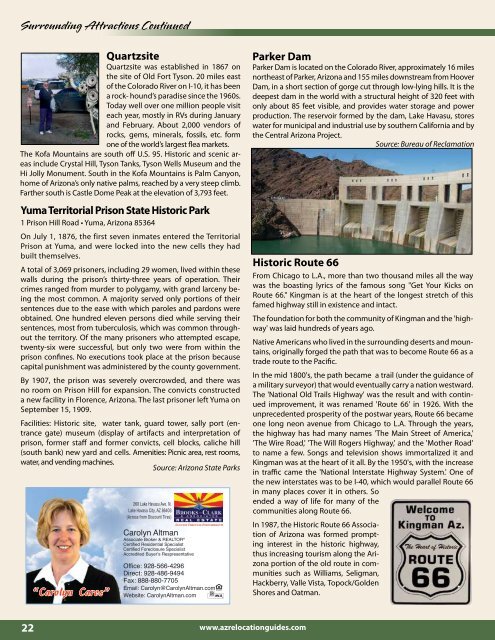
Parker Dam<br />
Parker Dam is located on the Colorado River, approximately 16 miles<br />
northeast of Parker, <strong>Arizona</strong> and 155 miles downstream from Hoover<br />
Dam, in a short section of gorge cut through low-lying hills. It is the<br />
deepest dam in the world with a structural height of 320 feet with<br />
only about 85 feet visible, and provides water storage and power<br />
production. The reservoir formed by the dam, <strong>Lake</strong> <strong>Havasu</strong>, stores<br />
water for municipal and industrial use by southern California and by<br />
the Central <strong>Arizona</strong> Project.<br />
Source: Bureau of Reclamation<br />
Historic Route 66<br />
From Chicago to L.A., more than two thousand miles all the way<br />
was the boasting lyrics of the famous song "Get Your Kicks on<br />
Route 66." Kingman is at the heart of the longest stretch of this<br />
famed highway still in existence and intact.<br />
The foundation for both the community of Kingman and the 'highway'<br />
was laid hundreds of years ago.<br />
Native Americans who lived in the surrounding deserts and mountains,<br />
originally forged the path that was to become Route 66 as a<br />
trade route to the Pacific.<br />
In the mid 1800's, the path became a trail (under the guidance of<br />
a military surveyor) that would eventually carry a nation westward.<br />
The 'National Old Trails Highway' was the result and with continued<br />
improvement, it was renamed 'Route 66' in 1926. With the<br />
unprecedented prosperity of the postwar years, Route 66 became<br />
one long neon avenue from Chicago to L.A. Through the years,<br />
the highway has had many names 'The Main Street of America,'<br />
'The Wire Road,' 'The Will Rogers Highway,' and the 'Mother Road'<br />
to name a few. Songs and television shows immortalized it and<br />
Kingman was at the heart of it all. By the 1950's, with the increase<br />
in traffic came the 'National Interstate Highway System.' One of<br />
the new interstates was to be I-40, which would parallel Route 66<br />
in many places cover it in others. So<br />
ended a way of life for many of the<br />
communities along Route 66.<br />
In 1987, the Historic Route 66 Association<br />
of <strong>Arizona</strong> was formed prompting<br />
interest in the historic highway,<br />
thus increasing tourism along the <strong>Arizona</strong><br />
portion of the old route in communities<br />
such as Williams, Seligman,<br />
Hackberry, Valle Vista, Topock/Golden<br />
Shores and Oatman.<br />
22<br />
www.azrelocationguides.com