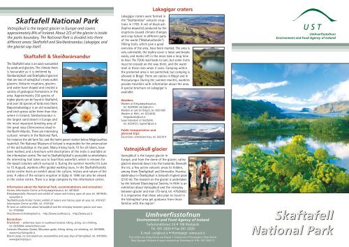
Skaftafell National Park Skaftafell National Park - Umhverfisstofnun
Skaftafell National Park Skaftafell National Park - Umhverfisstofnun
Skaftafell National Park Skaftafell National Park - Umhverfisstofnun

You also want an ePaper? Increase the reach of your titles
YUMPU automatically turns print PDFs into web optimized ePapers that Google loves.
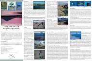
<strong>Skaftafell</strong> <strong>National</strong> <strong>Park</strong><br />
Vatnajökull is the largest glacier in Europe and covers<br />
approximately 8% of Iceland. About 2/3 of the glacier is inside<br />
the parks boundary. The <strong>National</strong> <strong>Park</strong> is divided into three<br />
different areas: <strong>Skaftafell</strong> and Skeiðarársandur, Lakagígar, and<br />
the glacial cap itself.<br />
<strong>Skaftafell</strong> & Skeiðarársandur<br />
The <strong>Skaftafell</strong> area is an oasis surounded<br />
by sands and glaciers. The climate there<br />
is favourable as it is sheltered by<br />
Skeiðarárjökull and Öræfajökull glaciers<br />
that are two of vatnajökul´s many outlet<br />
glaciers. Volcanic eruptions, glaciers<br />
and water have shaped and created a<br />
variety of geological formations in the<br />
area. Approximately 250 species of<br />
higher plants can be found in <strong>Skaftafell</strong>,<br />
and over 30 species of birds nest there.<br />
Bæjarstaðaskógur is an old woodland,<br />
and birch grows taller there than elsewhere<br />
in Iceland. Skeiðarársandur is<br />
the largest sand desert in Europe and<br />
the most important breeding area of<br />
the great skua (Stercorarius skua) in<br />
the North Atlantic. There are interesting<br />
cultural remains in the <strong>National</strong> <strong>Park</strong>,<br />
for instance the old farm Sel, and the home power station below Magnúsarfoss<br />
waterfall. The <strong>National</strong> Museum of Iceland is responsible for the preservation<br />
of the old buildings in the park. Many hiking trails, fit for all hikers, have<br />
been marked, and a brochure with descriptions of the trails is available at<br />
the information centre. The trail to <strong>Skaftafell</strong>sjökull is accessible to wheelchairs.<br />
An interesting trail takes you to Svartifoss waterfall, which is renown for<br />
the basalt columns which surround it. During the summer months (15 June<br />
to 15 August), wardens offer guided walking tours. In the <strong>Skaftafell</strong>sstofa<br />
visitor centre hosts an exhibit about the culture, history and nature of the<br />
area. A video of the volcanic eruption in Gjálp in 1996 can also be viewed<br />
in the visitor centre. There is a large campsite by the information centre.<br />
Information about the <strong>National</strong> <strong>Park</strong>, accommodations and recreation:<br />
Visitors Information Centre at Kirkjubæjarklaustur, tel. 4874620<br />
Kirkjubæjarstofa, Research and exhibit of nature and history, open all year, tel. 4874645;<br />
www.kbkl.is<br />
<strong>Skaftafell</strong>sstofa Visitor Centre, exhibit of nature and history, open all year, tel. 4781627<br />
Information Centre at Höfn, tel. 4781500<br />
ÍS-land, an exhibition about Vatnajökull and the interplay between glacier and man,<br />
tel. 4782665<br />
http://www.visitvatnajokull.is, http://www.southeast.is, http://www.ust.is<br />
Recreation:<br />
Öræfaferðir - wilderness tours in southeast Iceland, hiking, skiing, ice-climbing,<br />
tel. 8450894; www.hofsnes.com<br />
Icelandic Mountain Guides, Mountain guide, hiking, skiing, ice-climbing, tel. 5879999;<br />
www.mountainguide.is.<br />
Glacier jeeps, ice and adventure, snowmobiles and jeep-trips of Vatnajökull, tel. 4781000;<br />
www.glacierjeeps.is<br />
Lakagígar craters<br />
Lakagígar craters were formed in<br />
the "Skaftáreldar" volcanic eruptions<br />
in 1783. A veil of black ash<br />
(tephra deposits) produced by the<br />
eruptions caused climate changes<br />
and crop failure in different parts<br />
of the world ("Móðuharðindin").<br />
Hiking trails, which give a good<br />
overview of the area, have been marked. The area is<br />
very vulnerable, the tephra cover is loose and breaks<br />
easily, and marks left in the moss take a long time<br />
to heal. The F206 road leads to Laki, but some rivers<br />
must be crossed on the way there, and the water<br />
level in these rises when it rains. Camping within<br />
the protected area is not permitted, but camping is<br />
allowed in Blágil. There are cabins in Blágil and in<br />
Hrossatungur. During the summer months, wardens<br />
provide travellers with information about the area.<br />
A special brochure on Lakagígar is<br />
available.<br />
Wardens<br />
Warden at Kirkjubæjarklaustur,<br />
tel. 8224028; karik@ust.is<br />
Warden at Laki (in Blágil), tel. 8551095<br />
Warden at Höfn, tel. 8224036;<br />
helgadavids@ust.is<br />
Superintendent at <strong>Skaftafell</strong>,<br />
tel. 8224033; ragnarf@ust.is<br />
Public transportation and<br />
planned trips:<br />
Excursions, scheduled trips, tel. 5621011<br />
Vatnajökull glacier<br />
Vatnajökull is the largest glacier in<br />
Europe, and from the dome of the glacier, valley<br />
glaciers descend down into the lowlands. Beneath<br />
the ice, a few active volcanic areas lie hidden,<br />
among them Öræfajökull and Grímsvötn. Hvannadalshnúkur<br />
in Öræfajökull is Iceland's highest peak<br />
(2110 m). The research on the glacier is undertaken<br />
by the Iceland Glaciological Society. In Höfn is an<br />
exhibition about Vatnajökull and the interplay<br />
between glacier and man ( ÍS-land, tel. 4782665).<br />
It is imperative that those who plan to travel in<br />
the Vatnajökull area get guidance from those<br />
familiar with the region!<br />
<strong>Umhverfisstofnun</strong><br />
Environment and Food Agency of Iceland<br />
Suðurlandsbraut 24 • 108 Reykjavík<br />
Tel. 591 2000 • Fax 591 2020<br />
E-mail: ust@ust.is • Homepage: www.ust.is<br />
Text written by: Helga Davids and Ragnar F. Kristjánsson • Photographs: Helga Davids<br />
Map: Sigurgeir Skúlason • Layout and printing: Gutenberg hf. • Nr.: UST-2005:13<br />
<strong>Umhverfisstofnun</strong><br />
Environment and Food Agency of Iceland<br />
<strong>Skaftafell</strong><br />
<strong>National</strong> <strong>Park</strong>
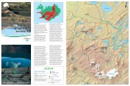
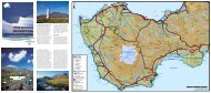
1 Grímsvötn lakes is the most<br />
active volcanic area in Iceland.<br />
The glacier melts because of<br />
geothermal heat, and water<br />
collects in a caldera beneath the<br />
ice, forming a lake which drains<br />
every few years and causes<br />
outburst floods, Skeiðarárhlaup.<br />
2 Lakagígar is a row of craters<br />
on a 25 km-long volcanic fissure.<br />
There is an excellent view of the<br />
craters from the mountain Laki.<br />
In Tjarnargígur crater there is a<br />
pond. Fagrifoss is a beautiful<br />
waterfall in Geirlandsá river.<br />
18 Svínafellsjökull glacier.<br />
East of <strong>Skaftafell</strong>sá river is a<br />
road leading to the snout of<br />
Svínafellsjökull. There is a hiking<br />
trail along the snout of the<br />
glacier.<br />
17 Hoffellsfjöll the nearby<br />
mountains are rich in secondary<br />
minerals, eg. opal, jaspis found<br />
in caveties in the rockformations.<br />
An interesting hiking trail takes<br />
you along Hoffellsjökull to Gjávatn<br />
lake. Old coastlines indicate<br />
that when the glacier was<br />
thicker, there was a great glacial<br />
lagoon in the Gjávatn area.<br />
16 Höfn, Jöklasýningin ÍS-land:<br />
An exhibition with information<br />
about the nature of glaciers, their<br />
effects on the environment,<br />
and the interplay between man<br />
and glacier.<br />
15 In Fláajökull glacier are<br />
prominent black patterns caused<br />
by volcanic ash (tephra). A good<br />
road, accessible to all cars, leads<br />
from the highway past the<br />
Hólmur farm to the snout of<br />
Fláajökull. The recreation and<br />
woodland area Haukafell and a<br />
camping area are east of<br />
Fláajökull.<br />
14 From the hill Eskey, west<br />
of Hólmsá, is an excellent view<br />
of Mýrar and the valley glaciers<br />
which flow down to the lowlands.<br />
On Eskey are information<br />
signs describing the glaciers and<br />
glacier lakes which have long<br />
threatened habitation in Mýrar.<br />
13 Heinabergsjökull glacier<br />
dams Vatnsdalur valley, and a<br />
lagoon has formed there. It<br />
drains out regularly. Earlier, the<br />
floods caused great damage to<br />
vegetation in the area. A hiking<br />
trail leads to the lagoon.<br />
3 Skeiðarárjökull is Europe's<br />
largest valley glacier. It has<br />
retreated 2 km since 1930.<br />
After big floods, Skeiðará was<br />
often impossible to cross and<br />
travellers had to go over the<br />
glacier above the area where the<br />
river emerges from it.<br />
4 Skeiðarársandur is a vast sand<br />
area, the biggest desert in Europe<br />
and the main breeding area of the<br />
great skua in Iceland. On the<br />
Skeiðarársandur east of the bridge<br />
across Skeiðará are information<br />
signs describing the volcanic<br />
eruptions in Grímsvötn, the<br />
Skeiðarárhlaup outburst floods,<br />
building of the bridges and remedy<br />
work after outburst floods.<br />
2<br />
Upplýsingamiðstöð, sími 4874620<br />
1<br />
3<br />
5<br />
4<br />
18<br />
6<br />
7<br />
8<br />
9<br />
10 11<br />
12<br />
15<br />
17<br />
13 14<br />
16<br />
Upplýsingamiðstöð,<br />
sími 4781500<br />
Upplýsingamiðstöð<br />
þjóðgarðsins,<br />
sími 4781627<br />
Suðurlandsbraut 24, 108 Rvk.<br />
Sími 591 2000 · Fax 591 2010<br />
ust@ust.is · www.ust.is<br />
12 Skálafellsjökull. Jöklajeppar<br />
snowmobile and jeep<br />
tours of Vatnajökull glacier leave<br />
from Skálafellsjökull glacier.<br />
Tel. 4781000. A jeep road takes<br />
you from Smyrlabjargavirkjun<br />
power station to the restaurant<br />
Jöklasel at the glacier's snoute.<br />
11 Breiðamerkurjökull glacier<br />
began retreating in 1930, and a<br />
deep lagoon was formed at the<br />
edge of the glacier. Jökulársarlón<br />
lagoon is covered with icebergs<br />
which break away from the<br />
glacier snout. By the restaurant<br />
at Jökulsárlón is an information<br />
sign describing the formation of<br />
the lagoon. Boat trips on the<br />
lagoon are offered daily.<br />
Tel. 4782122<br />
5 <strong>Skaftafell</strong>: Svartifoss is surrounded<br />
by basalt columns. The<br />
hiking trail to <strong>Skaftafell</strong>sjökull is<br />
accessible to wheelchairs. Sel is<br />
a turf farm special for its communal<br />
living room above the cowshed.<br />
The <strong>National</strong> Museum of Iceland<br />
owns and is responsible for the<br />
preservation of the farmhouse.<br />
6 Háalda is a drumlin south<br />
of Sandfell mountain. On it is<br />
a maar formed by an iceberg<br />
during the Öræfajökull volcanic<br />
eruption of 1727.<br />
7 Öræfajökull glacier erupted<br />
in 1362 and 1727. At the rim of<br />
the Öræfajökull caldera is<br />
Hvannadalshnúkur, Iceland's<br />
highest peak (2110 m).<br />
8 Esjufjöll mountains are<br />
surrounded by a glacier, where<br />
vegetation has evolved without<br />
influence of man and domestic<br />
animals.<br />
9 Kvíármýrarkambur is a glacial<br />
moraine rising 173 m above its<br />
surroundings. It is believed to<br />
have been formed approximately<br />
2500 years ago. Around 1870,<br />
Kvíárjökull glacier loomed higher<br />
than the moraine.<br />
10 Fjallsjökull and Hrútárjökull<br />
glaciers flow down from<br />
the east side of Öræfajökull<br />
glacier. A lagoon, Fjallsárlón, has<br />
formed next to Fjallsjökull, and it<br />
is frequently covered with<br />
icebergs.