Guide to Hydrological Practices, 6th edition, Volume I - Hydrology.nl
Guide to Hydrological Practices, 6th edition, Volume I - Hydrology.nl
Guide to Hydrological Practices, 6th edition, Volume I - Hydrology.nl

Create successful ePaper yourself
Turn your PDF publications into a flip-book with our unique Google optimized e-Paper software.
I.2-24<br />
GUIDE TO HYDROLOGICAL PRACTICES<br />
Optimize operations<br />
Operational procedures account for a significant<br />
portion of the cost of data collection. This includes<br />
the types of instrument, frequency of station visits<br />
and structure of field trips. The minimum-cost<br />
operational procedures should be adopted.<br />
Budget<br />
Based on the identified network and operational<br />
procedures, the cost of the operation of the network<br />
can be established. If this is within the budget, the<br />
next step can be followed. If not, either additional<br />
funding must be obtained or the objectives and/or<br />
priorities need <strong>to</strong> be examined <strong>to</strong> determine where<br />
costs may be reduced. The process adopted should<br />
allow the designer <strong>to</strong> express the impact of insufficient<br />
funding in terms of not meeting objectives or<br />
reduced information and net impacts.<br />
Implementation<br />
The redesigned network needs <strong>to</strong> be implemented<br />
in a planned manner. This will include both shortand<br />
long-term planning horizons.<br />
Review<br />
Since a number of the above components are<br />
variable in time, a review can be required at the<br />
instigation of any particular component – for<br />
example, changes in users or uses, or changes in the<br />
budget. To be ready <strong>to</strong> meet such changes, a<br />
continuous review process is essential.<br />
2.4.2 Density of stations for a network<br />
The concept of network density is intended <strong>to</strong> serve<br />
as a general guideline if specific guidance is lacking.<br />
As such, the design densities must be adjusted <strong>to</strong><br />
reflect actual socio-economic and physio-climatic<br />
conditions. Computer-based mathematical analysis<br />
techniques should also be applied, where data are<br />
available, <strong>to</strong> optimize the network density required<br />
<strong>to</strong> satisfy specific needs.<br />
As stated in 2.4.1.3.1, the minimum network is one<br />
that will avoid serious deficiencies in developing<br />
and managing water resources on a scale commensurate<br />
with the overall level of economic<br />
development and environmental needs of the<br />
country. It should be developed as rapidly as possible,<br />
incorporating existing stations, as appropriate.<br />
In other words, such a network will provide the<br />
framework for expansion <strong>to</strong> meet the information<br />
needs of specific water uses.<br />
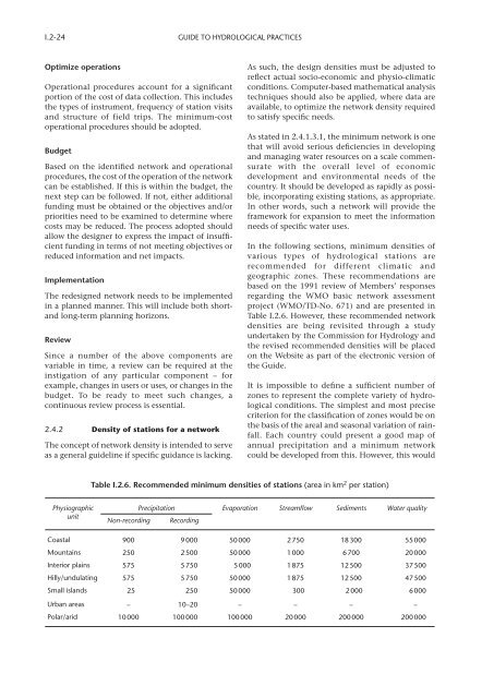
In the following sections, minimum densities of<br />
various types of hydrological stations are<br />
recommended for different climatic and<br />
geographic zones. These recommendations are<br />
based on the 1991 review of Members’ responses<br />
regarding the WMO basic network assessment<br />
project (WMO/TD-No. 671) and are presented in<br />
Table I.2.6. However, these recommended network<br />
densities are being revisited through a study<br />
undertaken by the Commission for <strong>Hydrology</strong> and<br />
the revised recommended densities will be placed<br />
on the Website as part of the electronic version of<br />
the <strong>Guide</strong>.<br />
It is impossible <strong>to</strong> define a sufficient number of<br />
zones <strong>to</strong> represent the complete variety of hydrological<br />
conditions. The simplest and most precise<br />
criterion for the classification of zones would be on<br />
the basis of the areal and seasonal variation of rainfall.<br />
Each country could present a good map of<br />
annual precipitation and a minimum network<br />
could be developed from this. However, this would<br />
Table I.2.6. Recommended minimum densities of stations (area in km 2 per station)<br />
Physiographic<br />
unit<br />
Precipitation Evaporation Streamflow Sediments Water quality<br />
Non-recording Recording<br />
Coastal 900 9000 50 000 2 750 18 300 55 000<br />
Mountains 250 2500 50 000 1 000 6 700 20 000<br />
Interior plains 575 5750 5 000 1 875 12 500 37 500<br />
Hilly/undulating 575 5750 50 000 1 875 12 500 47 500<br />
Small islands 25 250 50 000 300 2 000 6 000<br />
Urban areas – 10–20 – – – –<br />
Polar/arid 10000 100000 100 000 20 000 200 000 200 000