Landslide Types and Occurrence
Landslide Types and Occurrence
Landslide Types and Occurrence

Create successful ePaper yourself
Turn your PDF publications into a flip-book with our unique Google optimized e-Paper software.
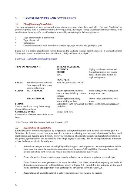
3. LANDSLIDE TYPES AND OCCURRENCE<br />
3.1 Classification of <strong>L<strong>and</strong>slide</strong>s<br />
The main categories of mass movement along slopes are creep, slide, flow <strong>and</strong> fall. The term “l<strong>and</strong>slide” is<br />
generally applied only to slope movements involving sliding, flowing or falling, occurring either individually, or in<br />
combination. More specific classification is achieved by describing the following features:<br />
* Type of movement in more detail<br />
* Type of material<br />
* Dimensions<br />
* Other characteristics such as moisture content, age, type location <strong>and</strong> geological type<br />
Figure 3.1 is a general classification system based on the l<strong>and</strong>slide features described above. It is modified from<br />
Varnes (1958) <strong>and</strong> include ideas from Hutchinson (1968) <strong>and</strong> Nemcok at al (1972).<br />
Figure 3.1 – <strong>L<strong>and</strong>slide</strong> classification system<br />
TYPE OF MOVEMENT<br />
FALLS<br />
SLIDES<br />
Material suddenly detached<br />
from slope with little or no<br />
shear displacement<br />
ROTATIONAL<br />
TRANSITIONAL<br />
FLOWS<br />
Slow or rapid, wet or dry flows along<br />
planar sliding surfaces<br />
COMPLEX TYPES<br />
Combination of one or more of the above<br />
types<br />
TYPE OF MATERIAL<br />
BEDROCK<br />
DEBRIS<br />
SOIL<br />
EXAMPLES<br />
Rock fall, debris fall, soil fall<br />
Shear displacement of partly<br />
coherent material along concave<br />
surfaces<br />
Shear displacement along<br />
Highly weathered to fresh rock<br />
Rocks fragments ± soil matrix<br />
S<strong>and</strong>, silt <strong>and</strong> clay. Soil in the<br />
engineering sense<br />
Earth slump, debris slump, rock<br />
slump, terracettes<br />
Debris slides, earth slides, rock<br />
planar sliding surfaces<br />
slides.<br />
Debris flow, earth flow, quick clay flow, solifluction, soil creep, dry<br />
s<strong>and</strong> flow.<br />
Slump, earth flow<br />
After Varnes 1958, Hutchinson 1968, <strong>and</strong> Nemcok 1972<br />
3.2 Recognition of <strong>L<strong>and</strong>slide</strong>s<br />
Recent l<strong>and</strong>slides are easily recognised by the presence of diagnostic features such as those shown on Figure 3.2.<br />
With time, the features become less prominent due to natural weathering processes <strong>and</strong> cultivation of the l<strong>and</strong>, until<br />
identification can become quite difficult. However, with the aid of aerial photography <strong>and</strong> careful observation on<br />
the ground, aged l<strong>and</strong>slides can be identified with a high degree of certainty. The following features are indicators<br />
of past l<strong>and</strong>slide activity in the study area:<br />
* Anomalous changes in slope, often highlighted by irregular shadow patterns. Arcuate depressions <strong>and</strong> the<br />
steep main scarps are the dominant geomorphological features of old l<strong>and</strong>slides. However, hummocky<br />
ground <strong>and</strong> lobate earth flows also remain as distinctive features for many years.<br />
* Zones of impeded drainage <strong>and</strong> seepage, usually indicated by variation in vegetation type <strong>and</strong> vigor.<br />
These features are more pronounced in recent l<strong>and</strong>slides, but colour infrared photography can assist in<br />
delineating moist zones in old l<strong>and</strong>slides as shown in Figure 3.3. Included in this category are the small<br />
basins of internal drainage which often contain pools of water as shown in Figure 2.5.<br />
* Accumulation of l<strong>and</strong>slide material in valleys <strong>and</strong> erosion of this material by streams.<br />
12
* Disturbed, displaced or covered: trees, roads, fences etc.<br />
Figure 3.2 – Diagrammatic representation of a typical slump – earth flow (After Varnes, 1958).<br />
Figure 3.3 – Oblique aerial infrared photograph of l<strong>and</strong>slide No. 10 on the Trafalgar-Thorpdale Road, near<br />
Ryans Road.<br />
Moist zones in the recent slump-earth flow are shown in green shadings. Features of the fossil <strong>and</strong> dormant<br />
l<strong>and</strong>slides to the left <strong>and</strong> in the background are more subdued. Unfortunately, the photograph is slightly out of<br />
focus.<br />
The following types of aerial photography were used in the study as an aid to l<strong>and</strong>slide recognition:<br />
* Black <strong>and</strong> white, vertical photography at 1:25 000 with stereoscopic cover<br />
* Oblique <strong>and</strong> vertical, large scale colour photography, sometimes with stereoscopic cover<br />
* Oblique, large scale colour infrared photography, with some stereoscopic cover<br />
13
The colour <strong>and</strong> infrared aerial photography was carried out by Mr B Sawyer of the Country Roads Board, Victoria.<br />
The use of detailed <strong>and</strong> varied aerial photography proved to be an extremely valuable means of studying l<strong>and</strong>slide<br />
development <strong>and</strong> morphology, <strong>and</strong> of recognizing old l<strong>and</strong>slides. Details of the photographic equipment <strong>and</strong><br />
techniques used are given in Appendix 3.1.<br />
3.3 <strong>L<strong>and</strong>slide</strong>s in the Study Area<br />
3.3.1 <strong>L<strong>and</strong>slide</strong> Distribution<br />
The distribution of old <strong>and</strong> recent l<strong>and</strong>slides was determined mainly by interpretation of 1:25 000 black <strong>and</strong> white<br />
vertical aerial photographs combined with careful field observation. The distribution was plotted on a 1:25 000<br />
base map then transferred to the 1:126 720 road base map for correlation with the geology, terrain <strong>and</strong> road maps in<br />
Section 6. The l<strong>and</strong>slide distribution map is included as Figure 3.4.<br />
3.3.2 Roadside <strong>L<strong>and</strong>slide</strong>s<br />
The locations of roadside l<strong>and</strong>slides listed by the Shire in 1975 are shown in Figure 3.5 in Appendix 1.2. In<br />
Section 4, the nature of each roadside l<strong>and</strong>slide <strong>and</strong> the damage caused is described together with details of the<br />
field work carried out. From this list, several typical l<strong>and</strong>slides are now selected to illustrate the nature of<br />
l<strong>and</strong>slides in the study area.<br />
Figure 3.4 – <strong>L<strong>and</strong>slide</strong> distribution for the Southern Districts of the Narracan Shire Location of<br />
Roadside <strong>L<strong>and</strong>slide</strong>s listed by the Shire in 1975<br />
14
3.3.3 <strong>L<strong>and</strong>slide</strong> <strong>Types</strong><br />
The most common l<strong>and</strong>slides are complex ones of the slump – earth flow type as shown in Figure 3.2, 3.6, 3.7 <strong>and</strong><br />
3.8. These l<strong>and</strong>slides disturb many hectares of l<strong>and</strong> <strong>and</strong> cause serious damage to the Shire roads each winter. The<br />
roads are narrowed by slumping, covered by earth flows <strong>and</strong> displaced laterally by creeping l<strong>and</strong>slide material.<br />
Figure 3.8 is a photograph of a typical large slump-earth flow which crosses the main Trafalgar to Thorpdale Road<br />
(<strong>L<strong>and</strong>slide</strong> No. 10).<br />
The slump-earth flows combine several types of movements. In the slump zone, where material is removed from<br />
the slope, the movement is dominantly rotational, but translational shear displacement can also occur. A typical<br />
slump zone is shown in Figure 3.6. The slumped material proceeds to break into smaller components <strong>and</strong> flow<br />
downslope as a wet viscous mass of earth as shown in Figure 3.7. The rate of flow is a function of the viscosity of<br />
the slope. Flow rates for fresh earth flows at the time of failure have been reported by local people to be in the<br />
order of 1 metre per minute, but accurate measurements have not been made. Following the initial period of<br />
relatively rapid flow, slow creep in the order of 1 metre per year or less can continue for many years,<br />
When l<strong>and</strong>slides originate within the road pavement (e.g. Figure 1.2), the material often consists predominantly of<br />
s<strong>and</strong> <strong>and</strong> gravel used in the construction of the road – especially when the road has been repetitively filled after<br />
previous small l<strong>and</strong>slides. These l<strong>and</strong>slides are also of the slump-flow type, but the term slump – debris flow<br />
should be used rather than slump-earth flow, because “earth” refers to s<strong>and</strong> silt <strong>and</strong> clay soils, while debris consists<br />
of rock fragments usually in a soil matrix. “Klevans” l<strong>and</strong>slide on the Yarragon to Leongatha Road is also a<br />
typical slump-debris flow, but in this case the l<strong>and</strong>slide occurs within the natural slope debris which consists of<br />
angular fragments of weathered mudstone in a clay <strong>and</strong> silt matrix.<br />
On grassed slopes, relatively shallow l<strong>and</strong>slides are common in which the movement is basically translational with<br />
shear displacement along approximately planar sliding surfaces. The movement usually terminates in an earth<br />
flow. Complex l<strong>and</strong>slide types occur between the translational l<strong>and</strong>slides <strong>and</strong> the slump-earth flows, but the two<br />
types dominant over the variations in-between. The translational l<strong>and</strong>slides are typically small features in contrast<br />
to the relatively large <strong>and</strong> damaging slump-earth flows. A diagrammatic representation of a typical translational<br />
l<strong>and</strong>slide is shown in Figure 3.9. Shallow translational l<strong>and</strong>slides are also referred to as “sheet slides” (Zàruba <strong>and</strong><br />
Mencl, 1969) or “slip-off slop l<strong>and</strong>slides” (Jones, 1961).<br />
Other slope movements operating in the study area include soil creep, rock falls, <strong>and</strong> possibly small terracettes.<br />
Soil creep is a long term process in which the velocity does not increase. Rock falls are rare, <strong>and</strong> are confined to<br />
15
the steep road cuttings in the Lower Cretaceous s<strong>and</strong>stones <strong>and</strong> mudstones. Small ridges contouring the hillslopes<br />
are common <strong>and</strong> most probably are due to contour ploughing <strong>and</strong>/or cow tracks, but it is possible that in some<br />
cases they are small stepped rotational l<strong>and</strong>slides called terracettes.<br />
Figure 3.6 – Slump zone of active slump-earth flow, Dingley Dell. July 1978.<br />
Figure 3.7 – Toe of earth flow zone of recent l<strong>and</strong>slide, Dingley Dell. July 1978.<br />
16
Figure 3.8 – Slump-earth flow cutting across Trafalgar-Thorpdale Road. Slump zone above the road, earth<br />
flow zone below road. Winter 1978.<br />
17
Figure 3.9 – Diagrammatic representation of a typical translational l<strong>and</strong>slide.<br />
3.3.4 The Age of <strong>L<strong>and</strong>slide</strong>s<br />
Zàruba <strong>and</strong> Mencl (1969), distinguish the following 3 classes of l<strong>and</strong>slides according to age:<br />
1. Contemporary or recent l<strong>and</strong>slides which are usually active <strong>and</strong> easily recognized by the sharp<br />
topographic expression of the l<strong>and</strong>slide features.<br />
2. Dormant l<strong>and</strong>slides in which the topographic expression is obscure <strong>and</strong> recognition may be difficult;<br />
though the cause of the movement may be renewed.<br />
3. Fossil l<strong>and</strong>slides generally developed in the Pleistocene or earlier periods, under different morphological<br />
<strong>and</strong> climatic conditions. Movement cannot be repeated under present conditions.<br />
Evans <strong>and</strong> Joyce (1974) point out that the l<strong>and</strong>slides were observed in Victoria before any l<strong>and</strong> clearing <strong>and</strong><br />
farming took place. For example, Major Mitchell commented on l<strong>and</strong>slides in the Glenelg River Valley near<br />
Coleraine, Victoria in 1839. Similar historical accounts of pre-settlement l<strong>and</strong>slides are not known for the<br />
Strzelecki Ranges, probably because the dense forest made observation difficult. It is certain though, that<br />
l<strong>and</strong>slides did exist in the Strzelecki Ranges prior to settlement. Much of the l<strong>and</strong>scape has been shaped into large<br />
arcuata depressions on a scale that would certainly have raised considerable comment among the early settler if<br />
l<strong>and</strong>slides of such magnitude had followed the clearing of the forest. Early newspapers record details of other<br />
natural hazards such as floods <strong>and</strong> fires, but no mention is made of large l<strong>and</strong>slides. These l<strong>and</strong>slides are more than<br />
a kilometre across in places <strong>and</strong> represent the natural maturing of the l<strong>and</strong>scape as stored energy is released during<br />
weathering <strong>and</strong> unloading. They probably occurred during the Pleistocene when different climatic conditions<br />
existed, <strong>and</strong> as such, would be classified as fossil l<strong>and</strong>slides.<br />
A dominant characteristic of the l<strong>and</strong>slides is the tendency for progressively smaller l<strong>and</strong>slides to develop on larger<br />
pre-existing ones. In the Dingley Dell l<strong>and</strong>slide complex, at least 3 generations of l<strong>and</strong>sliding can be observed.<br />
Fossil, dormant <strong>and</strong> recent l<strong>and</strong>slides are all present as shown in Figure 3.10. The recent l<strong>and</strong>slides affect less than<br />
10% of the fossil l<strong>and</strong>slide area, nevertheless they have caused considerable damage to farm l<strong>and</strong> <strong>and</strong> have closed<br />
the Dingley Dell Road.<br />
18
Figure 3.10 – Dingley Dell l<strong>and</strong>slide complex, consisting of at least 3 generations of multiple slumpearth<br />
flows.<br />
The entire foreground is a fossil l<strong>and</strong>slide, clearly defined by the large arcuata depression at the head of the slump<br />
zone. Numerous grassed dormant l<strong>and</strong>slides are superimposed on the fossil l<strong>and</strong>slide. The active l<strong>and</strong>slides are<br />
obvious from fresh earth scars <strong>and</strong> earth flows. The Dingley Dell Road traverses the area. At point A, the road is<br />
entirely removed by a slump <strong>and</strong> at point B it is covered by an earth flow. Following heavy rain, further<br />
l<strong>and</strong>sliding occurred below a dam (point C) a few week after this photograph was taken in winter 1978.<br />
19