Bribie Island Brochure - Moreton Bay Regional Council
Bribie Island Brochure - Moreton Bay Regional Council
Bribie Island Brochure - Moreton Bay Regional Council

Create successful ePaper yourself
Turn your PDF publications into a flip-book with our unique Google optimized e-Paper software.
History of the catchment<br />
The Gubbi Gubbi people were the original inhabitants of<br />
<strong>Bribie</strong> <strong>Island</strong>. Aboriginal artefacts still found today include<br />
the remains of bora grounds, fish traps and shell middens.<br />
Aboriginal artefacts are protected under the Queensland<br />
Aboriginal Cultural Act 2003.<br />
Matthew Flinders came to the Pumicestone Passage in<br />
1799. However, the first European settlement was not until<br />
1822. More recent events include:<br />
► 1860s: pastoralists and timber-getters moved onto the<br />
island<br />
► Late 1960s: pine plantations established<br />
► 1963: toll bridge opened and started <strong>Bribie</strong> <strong>Island</strong> on a<br />
course of increased urban development<br />
► Late 1970s and 1980s: development of the island's first<br />
canal estate<br />
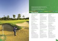
Recreational options on <strong>Bribie</strong> <strong>Island</strong><br />
► Windsurfing or catamaran sailing on Pumicestone<br />
Passage and the open waters off Woorim Beach<br />
► The patrolled surf beach at Woorim is a venue for<br />
regular surf carnivals, attracting swimmers and board<br />
riders<br />
► Water skiing and jet skiing in the calmer waters of the<br />
Passage<br />
► Surf fishing is popular at Skirmish Point, Woorim and<br />
along the expanse of<br />
the ocean beach<br />
► Visit the bird hide at<br />
Buckley's Hole, south<br />
Bongaree, where<br />
you will see some of<br />
the 350 species of Fishing in Pumicestone Passage<br />
birds that inhabit this<br />
environmental park<br />
► Follow walking tracks at White Patch to wild flowers that<br />
are in season from July to November<br />
Caboolture Catchments: <strong>Bribie</strong> <strong>Island</strong><br />
► Bicentennial Gardens, located near the Community Arts<br />
Centre on Sunderland Drive, is wheelchair accessible.<br />
A map of the walks is available<br />
from the Arts Centre for a small<br />
charge. For bird watchers, about<br />
90 species of birds have been<br />
sighted in this small area<br />
► Camping in the Recreation<br />
Reserve on the eastern side of<br />
the island. Contact Queensland<br />
Parks and Wildlife Service for a<br />
permit to camp or four wheeldrive<br />
permit to access these areas<br />
Plants and wildlife<br />
Park signage<br />
The Pumicestone Passage became part of the <strong>Moreton</strong><br />
<strong>Bay</strong> Marine Park in 1986 to protect the fish breeding areas<br />
around Tripcony Bight. Under the Marine Parks (<strong>Moreton</strong><br />
<strong>Bay</strong>) Zoning Plan 1997, Tripcony Bight is closed to fishing<br />
and all forms of extractive use. Areas of Pumicestone<br />
Passage and the eastern coastal rim of <strong>Bribie</strong> <strong>Island</strong> are<br />
also identified under the state government Fisheries Act<br />
(1994) as fish habitat, so approval is needed for any works<br />
that could disturb, destroy or damage marine plants.<br />
<strong>Bribie</strong> <strong>Island</strong> vegetation communities include heathlands,<br />
coastal dunes, beach ridge vegetation, and freshwater/<br />
estuarine wetlands of fringing mangroves. Fauna include<br />
Dugong (Dugong dugon) and the Wallum Froglet (Crinia<br />
tinnula). The Eastern Curlew (Numenius madagascariensis)<br />
is one of over 30 migratory shorebirds of international<br />
significance.<br />
Melaleuca wetlands on the island tend to be acidic and<br />
support three species of acid frogs not known to occur<br />
together anywhere else in the world. These frogs now reside<br />
in the coastal lowlands, which are in demand for residential<br />
development.<br />
Callitris columellaris, or <strong>Bribie</strong> <strong>Island</strong> Pine is one of three<br />
native Callitris spp. It is not a member of the pine family,<br />
although it resembles many of the exotic pines. Endemic to<br />
the Sunshine Coast region, it is found across the island and<br />
adjacent coastal areas.<br />
Spring wildflowers create a visual feast of colour and<br />
texture, plus a hive of activity for the birds and insects of<br />
the region. Local groups on the island conduct wildflower<br />
walks in these times. Swamp wallabies and squirrel gliders<br />
can also be seen regularly.<br />
Issues affecting <strong>Bribie</strong> <strong>Island</strong> catchments<br />
Population growth and urban development has increased<br />
stormwater runoff and disturbance to Acid Sulfate Soils.<br />
Other environmental threats include wild fires, loss of<br />
natural ecosystems (e.g. Melaleuca wetland and heath<br />
communities) and increased demand for access to<br />
groundwater.<br />
Introduced exotic pine plantations<br />
in the 1960s changed the<br />
northern half of the island.<br />
However, the central swale and<br />
perimeter dune are part of the<br />
“<strong>Bribie</strong> <strong>Island</strong> Recreation Area”.<br />
Water supply<br />
Coastal dunes<br />
Caboolture Shire <strong>Council</strong> has operated a water treatment<br />
plant on <strong>Bribie</strong> <strong>Island</strong> since 1961. This was upgraded in<br />
1972 and again in 1981. The plant now draws water from<br />
the freshwater aquifer on the island at between four and<br />
five megalitres per day. <strong>Council</strong> regularly monitors the<br />
water extraction to minimise environmental impacts. The<br />
exclusion of seawater from the system is important to the<br />
management of the island's freshwater aquifer.<br />
CABOOLTURE SHIRE COUNCIL www.caboolture.qld.gov.au


![Kumbartcho Brochure [PDF 540KB] - Moreton Bay Regional Council](https://img.yumpu.com/47220970/1/190x101/kumbartcho-brochure-pdf-540kb-moreton-bay-regional-council.jpg?quality=85)