Waypoint Naming Conventions
Waypoint Naming Conventions
Waypoint Naming Conventions

You also want an ePaper? Increase the reach of your titles
YUMPU automatically turns print PDFs into web optimized ePapers that Google loves.
<strong>Waypoint</strong> <strong>Naming</strong> <strong>Conventions</strong><br />
ARINC Specification 424 provides waypoint naming conventions used in the database. Listed<br />
below are examples of the most common ones that might be encountered when accessing the<br />
Navigation Database.<br />
D235H DME waypoint on radial 235°at 8 nm (H is 8 TH letter)<br />
XYZ29 Point identified by “X” on enroute chart, 29 nm from the XYZ VOR (distances less than<br />
100 nm)<br />
12ABC Point identified by “X” on enroute chart, 112 nm from the ABC VOR (distances greater<br />
than 100 nm)<br />
FF26 FAF for Runway 26<br />
OM26 Outer Marker for Runway 26<br />
MM26 Middle Marker for Runway 26<br />
CF26 FACF for Runway 26 (usually located on final approach course 2-5 nm outside of FAF)<br />
RW26 Threshold coordinates for Runway 26<br />
MA26 Missed Approach Point (MAP) for Runway 26<br />
R-345 DME Arc Terminator on radial 345°<br />
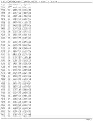
Example Latitude/Longitude Named <strong>Waypoint</strong>s (Oceanic):<br />
ARINC 424 Format FMS Lat/Long Format<br />
5275N<br />
52N075W<br />
75N70<br />
75N170W<br />
5020E<br />
50N020E<br />
50E20<br />
50N120E<br />
5275W<br />
52S075W<br />
52W20<br />
52S120W<br />
6030S<br />
60S030E<br />
60S30<br />
60S130E<br />
Oceanic waypoints (OWPTs) are used for aircraft position reporting upon entry to and exit from<br />
oceanic control areas. In the Navigation Database, these waypoints have a five character<br />
identifier consisting of the latitude and longitude of the waypoint. The FMS converts this five<br />
character identifier to a seven character identifier for screens allowing the display of seven<br />
characters or more. For fields that allow less than seven character identifiers, the five character<br />
identifier is displayed. When manually entering a waypoint identifier, the FMS accepts either the<br />
five or seven character OWPT identifier.<br />
For example, an oceanic waypoint with coordinates of 52:00:00 North Latitude, 75:00:00 West<br />
Longitude has the five letter identifier 5275N in the Navigation Database. When the FMS converts<br />
it to a seven letter identifier, it is displayed as 52N075W.<br />
NOTE: The Navigation Database contains mileage breaks or turning points (unnamed<br />
intersections) which are identified on enroute charts only by an “X”. To interrogate a mileage<br />
break up to and including 99 DME from the associated navaid, enter the navaid identifier, then<br />
the DME distance to the point. For example, if the mileage break were 54 DME<br />
from PDX, then the proper entry would be PDX54. To interrogate a mileage break 100 DME or<br />
farther from the associated navaid, enter the last two digits followed immediately by the navaid<br />
identifier. For example, if the mileage break were 110 DME from FST, then the proper entry<br />
would be 10FST.<br />
The following are examples of different enroute, terminal and approach waypoint naming<br />
conventions:
• R-123 - DME ARC terminator on 123° radial<br />
• TUS – Typically a navaid, e.g., the TUS VOR (or NDB)<br />
• BASER - A pronounceable 5-letter intersection name<br />
• TUS45 - A 45 DME fix from the TUS VOR<br />
• 21TRM - A 121 DME fix from the TRM VOR<br />
• MA123 - The MAP for a circling procedure, lying on the 123 degree radial from (or bearing to)<br />
the referenced navaid.