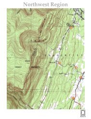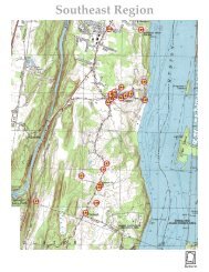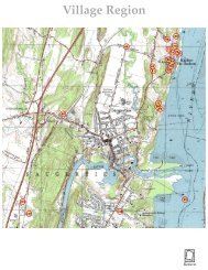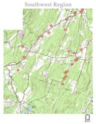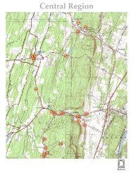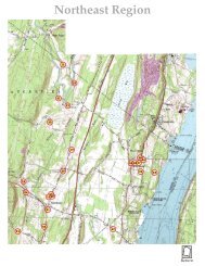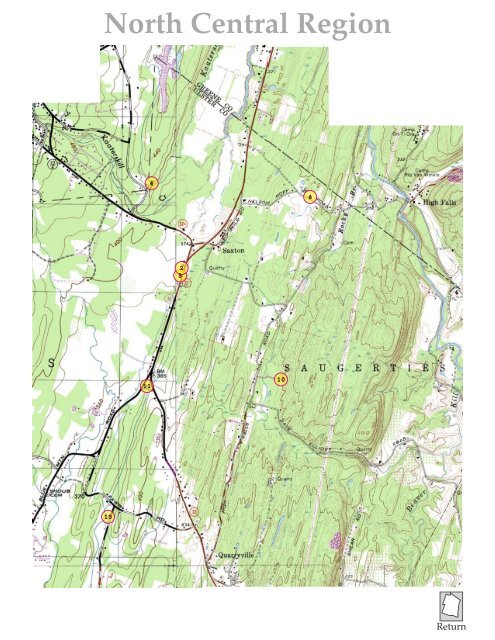
North Central Region

You also want an ePaper? Increase the reach of your titles
YUMPU automatically turns print PDFs into web optimized ePapers that Google loves.
<strong>North</strong> <strong>Central</strong> <strong>Region</strong><br />
4<br />
6<br />
2<br />
3<br />
11<br />
10<br />
13<br />
Return
74º05’<br />
16.002<br />
27.002<br />
27.004<br />
Xx<br />
74º04’<br />
7.004<br />
74º03’<br />
17.005<br />
28.001<br />
74º02’<br />
8.001<br />
8.003<br />
17.001<br />
28.003<br />
17.048<br />
16.004 17.003<br />
74º01’<br />
2.003<br />
17.007<br />
17.051<br />
74º00’<br />
28.002<br />
28.011<br />
8.002<br />
17.002<br />
17.015<br />
28.058<br />
2.004<br />
18.004<br />
17.016<br />
17.004<br />
28.004<br />
73º59’<br />
73º58’<br />
19.001<br />
18.001<br />
29.013<br />
29.003<br />
73º57’<br />
9.003<br />
29.005<br />
29.009<br />
40.001<br />
18.055<br />
29.046<br />
29.047<br />
18.010<br />
73º56’<br />
73º55’<br />
42º10’<br />
42º09’30”<br />
42º09’<br />
42º08’30”<br />
42º08’<br />
42º07’30”<br />
42º07’<br />
42º06’30”<br />
42º06’<br />
42º05’30”<br />
42º05’<br />
42º04’30”<br />
42º04’<br />
42º03’30”<br />
42º03’<br />
42º02’30”<br />
42º02’<br />
42º01’30”<br />
42º01’<br />
42º00’30”<br />
42º00’<br />
© 2004, M. S. Smith<br />
73º54’<br />
3955 Route 32<br />
2.3-3-31<br />
42º09'16"N, 73º59'58"W<br />
2005 Survey Landmark #2<br />
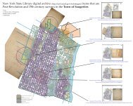
Town of Saugerties, NY<br />
N<br />
Pages from Town of Saugerties, New York, Historic Resources Survey, March, 2005<br />
Narrative additions<br />
This house is an unaltered example of the residential style<br />
that began to be built as farming became less a prime<br />
employer and first generation off-the-farm began to<br />
approach the road frontage of the farmland as an<br />
automobile access to jobs in the factories of the village area.<br />
W<br />
S<br />
E<br />
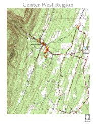
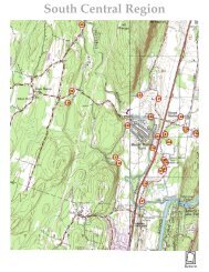
Detail from the revised 1963 Geological Survey overlayed with an Ulster County parcel map scaled section.<br />
0 ¼ ½ ¾ 1 Mile<br />
Photo<br />
1<br />
Photo<br />
2<br />
N<br />
W<br />
E<br />
S<br />
0 165 feet<br />
1/8 Mile<br />
Town of Saugerties 2004-2005 Historic Resources Survey<br />
Note: Graphics including outlines of structures and lot lines are schematic. All photo locations are approximate.<br />
Locator map from survey documentation<br />
#1 #2<br />
Numbered descriptive photos from survey documentation
74º05’<br />
16.002<br />
27.002<br />
27.004<br />
Xx<br />
74º04’<br />
7.004<br />
74º03’<br />
17.005<br />
28.001<br />
74º02’<br />
8.001<br />
8.003<br />
17.001<br />
28.003<br />
17.048<br />
16.004 17.003<br />
74º01’<br />
2.003<br />
17.007<br />
17.051<br />
74º00’<br />
28.002<br />
28.011<br />
8.002<br />
17.002<br />
17.015<br />
28.058<br />
2.004<br />
18.004<br />
17.016<br />
17.004<br />
28.004<br />
73º59’<br />
73º58’<br />
19.001<br />
18.001<br />
29.013<br />
29.003<br />
73º57’<br />
9.003<br />
29.005<br />
29.009<br />
40.001<br />
18.055<br />
29.046<br />
29.047<br />
18.010<br />
73º56’<br />
73º55’<br />
42º10’<br />
42º09’30”<br />
42º09’<br />
42º08’30”<br />
42º08’<br />
42º07’30”<br />
42º07’<br />
42º06’30”<br />
42º06’<br />
42º05’30”<br />
42º05’<br />
42º04’30”<br />
42º04’<br />
42º03’30”<br />
42º03’<br />
42º02’30”<br />
42º02’<br />
42º01’30”<br />
42º01’<br />
42º00’30”<br />
42º00’<br />
© 2004, M. S. Smith<br />
73º54’<br />
3949 Route 32<br />
2.3-3-33<br />
42º09'12"N, 73º59'59"W<br />
2005 Survey Landmark #3<br />
Town of Saugerties, NY<br />
N<br />
Pages from Town of Saugerties, New York, Historic Resources Survey, March, 2005<br />
Narrative additions:<br />
This is School number 3 on the 1875 Beers Atlas Map of the<br />
Town. On this map the Town is divided into numbered<br />
districts with the school numbers corresponding to these.<br />
For instance, this school is in district 3 and the West<br />
Saugerties school #12 is in number 12. Presumably these<br />
date to the same period of construction. However, some, as<br />
in the Veteran stone schoolhouse of 1842 and the Flatbush<br />
school of 1890 seem to be earlier or replacements. The<br />
frame structures were likely all of the same date.<br />
This particular building, if it is the same footprint as the<br />
original, was large by comparison to the other one-room<br />
schoolhouses. If so, it would be of later construction. It is in<br />
seriously abused condition as were many of the other<br />
excessed structures sold by the consolidated district in the<br />
1960’s. This, at least, is still standing. The Cedar Grove<br />
schoolhouse was destroyed recently.<br />
This schoolhouse does not appear to be a symbol on the<br />
1963 USGS topo map. At the parcel location there is no<br />
structure symbol at all. There is one further back and this<br />
may have been a moved building.<br />
W<br />
N<br />
S<br />
E<br />
W<br />
S<br />
E<br />
Detail from the revised 1963 Geological Survey overlayed with an Ulster County parcel map scaled section.<br />
0 ¼ ½ ¾ 1 Mile<br />
Photo<br />
Photo<br />
0 165 feet<br />
1/8 Mile<br />
Town of Saugerties 2004-2005 Historic Resources Survey<br />
Note: Graphics including outlines of structures and lot lines are schematic. All photo locations are approximate.<br />
1<br />
2<br />
Locator map from survey documentation<br />
#1 #2<br />
Numbered descriptive photos from survey documentation
74º05’<br />
16.002<br />
27.002<br />
27.004<br />
Xx<br />
74º04’<br />
7.004<br />
74º03’<br />
17.005<br />
28.001<br />
74º02’<br />
8.001<br />
8.003<br />
17.001<br />
28.003<br />
17.048<br />
16.004 17.003<br />
74º01’<br />
2.003<br />
17.007<br />
17.051<br />
74º00’<br />
28.002<br />
28.011<br />
8.002<br />
17.002<br />
17.015<br />
28.058<br />
2.004<br />
18.004<br />
17.016<br />
17.004<br />
28.004<br />
73º59’<br />
73º58’<br />
19.001<br />
18.001<br />
29.013<br />
29.003<br />
73º57’<br />
9.003<br />
29.005<br />
29.009<br />
40.001<br />
18.055<br />
29.046<br />
29.047<br />
18.010<br />
73º56’<br />
73º55’<br />
42º10’<br />
42º09’30”<br />
42º09’<br />
42º08’30”<br />
42º08’<br />
42º07’30”<br />
42º07’<br />
42º06’30”<br />
42º06’<br />
42º05’30”<br />
42º05’<br />
42º04’30”<br />
42º04’<br />
42º03’30”<br />
42º03’<br />
42º02’30”<br />
42º02’<br />
42º01’30”<br />
42º01’<br />
42º00’30”<br />
42º00’<br />
© 2004, M. S. Smith<br />
73º54’<br />
1452 Drummond Falls Road<br />
2.4-1-8<br />
42º09'49"N, 74º00'12"W<br />
2005 Survey Landmark #4<br />
Town of Saugerties, NY<br />
N<br />
Pages from Town of Saugerties, New York, Historic Resources Survey, March, 2005<br />
Narrative additions:<br />
The ruin noted on this property along the stream that runs<br />
through its middle is at the location on the Kingston<br />
Commons survey map of 1803 designated “Old Mill of<br />
Burhans”. This is a landmark within the northern boundary<br />
on this survey but on land described as that of “Myer and<br />
Wynkoop - Bounds of Kingston” on the 1811 division map.<br />
W<br />
S<br />
E<br />
Photo<br />
Detail from the revised 1963 Geological Survey overlayed with an Ulster County parcel map scaled section.<br />
0 ¼ ½ ¾ 1 Mile<br />
4<br />
Photo<br />
3<br />
Photo<br />
1<br />
Photo<br />
2<br />
N<br />
W<br />
E<br />
S<br />
0 165 feet<br />
1/8 Mile<br />
Town of Saugerties 2004-2005 Historic Resources Survey<br />
Note: Graphics including outlines of structures and lot lines are schematic. All photo locations are approximate.<br />
Locator map from survey documentation<br />
#1<br />
#2<br />
#3<br />
#4<br />
Numbered descriptive photos from survey documentation
74º05’<br />
16.002<br />
27.002<br />
27.004<br />
Xx<br />
74º04’<br />
7.004<br />
74º03’<br />
17.005<br />
28.001<br />
74º02’<br />
8.001<br />
8.003<br />
17.001<br />
28.003<br />
17.048<br />
16.004 17.003<br />
74º01’<br />
2.003<br />
17.007<br />
17.051<br />
74º00’<br />
28.002<br />
28.011<br />
8.002<br />
17.002<br />
17.015<br />
28.058<br />
2.004<br />
18.004<br />
17.016<br />
17.004<br />
28.004<br />
73º59’<br />
73º58’<br />
19.001<br />
18.001<br />
29.013<br />
29.003<br />
73º57’<br />
9.003<br />
29.005<br />
29.009<br />
40.001<br />
18.055<br />
29.046<br />
29.047<br />
18.010<br />
73º56’<br />
73º55’<br />
42º10’<br />
42º09’30”<br />
42º09’<br />
42º08’30”<br />
42º08’<br />
42º07’30”<br />
42º07’<br />
42º06’30”<br />
42º06’<br />
42º05’30”<br />
42º05’<br />
42º04’30”<br />
42º04’<br />
42º03’30”<br />
42º03’<br />
42º02’30”<br />
42º02’<br />
42º01’30”<br />
42º01’<br />
42º00’30”<br />
42º00’<br />
© 2004, M. S. Smith<br />
73º54’<br />
56 Nelson Hoff Road<br />
2.4-2-34<br />
42º09'45"N, 73º58'54"W<br />
2005 Survey Landmark #6<br />
Town of Saugerties, NY<br />
N<br />
Pages from Town of Saugerties, New York, Historic Resources Survey, March, 2005<br />
Narrative additions:<br />
c 1790 Schoonmaker-Hoff Homestead<br />
W<br />
S<br />
E<br />
Detail from the revised 1963 Geological Survey overlayed with an Ulster County parcel map scaled section.<br />
0 ¼ ½ ¾ 1 Mile<br />
Photo<br />
2<br />
Photo<br />
1<br />
N<br />
W<br />
E<br />
S<br />
0 165 feet<br />
1/8 Mile<br />
Town of Saugerties 2004-2005 Historic Resources Survey<br />
Note: Graphics including outlines of structures and lot lines are schematic. All photo locations are approximate.<br />
Locator map from survey documentation<br />
#1 #2<br />
Numbered descriptive photos from survey documentation
74º05’<br />
16.002<br />
27.002<br />
27.004<br />
Xx<br />
74º04’<br />
7.004<br />
74º03’<br />
17.005<br />
28.001<br />
74º02’<br />
8.001<br />
8.003<br />
17.001<br />
28.003<br />
17.048<br />
16.004 17.003<br />
74º01’<br />
2.003<br />
17.007<br />
17.051<br />
74º00’<br />
28.002<br />
28.011<br />
8.002<br />
17.002<br />
17.015<br />
28.058<br />
2.004<br />
18.004<br />
17.016<br />
17.004<br />
28.004<br />
73º59’<br />
73º58’<br />
19.001<br />
18.001<br />
29.013<br />
29.003<br />
73º57’<br />
9.003<br />
29.005<br />
29.009<br />
40.001<br />
18.055<br />
29.046<br />
29.047<br />
18.010<br />
73º56’<br />
73º55’<br />
42º10’<br />
42º09’30”<br />
42º09’<br />
42º08’30”<br />
42º08’<br />
42º07’30”<br />
42º07’<br />
42º06’30”<br />
42º06’<br />
42º05’30”<br />
42º05’<br />
42º04’30”<br />
42º04’<br />
42º03’30”<br />
42º03’<br />
42º02’30”<br />
42º02’<br />
42º01’30”<br />
42º01’<br />
42º00’30”<br />
42º00’<br />
© 2004, M. S. Smith<br />
73º54’<br />
302 High Falls Road<br />
8.2-3-23<br />
42º08'38"N, 73º59'07"W<br />
A designated landmark<br />
of<br />
The Historic Preservation Commission<br />
of the Town of Saugerties<br />
CLICK HERE<br />
for<br />
Designation Documentation<br />
2005 Survey Landmark #10<br />
Town of Saugerties, NY<br />
N<br />
Pages from Town of Saugerties, New York, Historic Resources Survey, March, 2005<br />
Narrative additions:<br />
Michael McCabe Farm<br />
This property would be best known as the school of the artist Abram August Champanier. It<br />
functioned in this respect throughout the decades of the 1940's and 50's.<br />
The Michael McCabe Farm is a prime example of a property that has gracefully transitioned from<br />
the nineteenth century to the twentieth. Much of the local economy in this period went from a land<br />
supported to a service oriented one. In the 1800's most farms were self-supporting through cash<br />
crops and bluestone quarrying. Into the next century many survived as boarding houses for<br />
summer visitors. Some of these visitors purchased farms as second residences. Locally, in the<br />
Saugerties and Woodstock area these were often artists.<br />
A. A. Champanier is typical of the successful artists from New York City that took up residence<br />
here to run schools for the many summer art students attracted to the area by a community<br />
centered on the Art Students League school in Woodstock. At various times he had his school in<br />
Woodstock, Kingston and at this farm. After the farm his school was named the Saxton Falls School<br />
of Art.<br />
The deed to A. A. Champanier references Michael McCabe as the original owner of the<br />
consolidated 3 lots (68 acres) it described. This is the reason for its name. Each of the McCabe lots in<br />
turn referenced number designations of 6th Class lots in a division map of the Kingston Commons.<br />
The single lot of these three that is now designated the Michael McCabe Farm is number 30 in the<br />
6th Class. This is described as 23 19/100 acres and is the earliest one of McCabe's three purchases<br />
(1852). Its description places the lot bordering the east side of the "Highway from Quarryville to the<br />
Great Falls". A previous transfer to David Ransom from Ephram Myer puts the acreage at 28 1/2,<br />
which is closer to the full lot size of the original Kingston Commons division map. This included<br />
the land on the west side of the road.<br />
The intact boundary walls that define the north and east borders of this farm are one of the most<br />
important historical assets of the town. These are the only landmarks on the USGS topographical<br />
map of Saugerties representing the 1804 distribution of the Kingston Commons. Their directions<br />
and point of intersection make up the only physical reference for accurately finding all other<br />
locations deeded out of that historic survey.<br />
It is important to recognize that hundreds of similar stone walls filling similar functions are found<br />
throughout the town. These walls are important because they are recorded on the USGS map and<br />
thus are measurably placed as a topographical feature of the town.<br />
The stone entry level of the Michael McCabe house was likely built at the time he made the 1852<br />
purchase. It takes advantage of the ready supply of cut stone from the many active quarries nearby<br />
in Quarryville. The Beers Atlas of 1875 places the house in its present location and under the name<br />
"M. McCabe". The 1893 USGS, one of the first, also places this house. These make its relatively<br />
secluded location an historically recognized feature of the town.<br />
The house suffered a fire in 1989 but though changed in its upper floors has mostly retained the<br />
texture and feel of the original inside and out. The acreage of the farm retains a quality of its rural<br />
setting preserved by the sensitivity of its artist owners from A. A. Champanier on to the present.<br />
W<br />
N<br />
S<br />
E<br />
W<br />
S<br />
E<br />
Detail from the revised 1963 Geological Survey overlayed with an Ulster County parcel map scaled section.<br />
0 ¼ ½ ¾ 1 Mile<br />
Photo<br />
0 165 feet<br />
1/8 Mile<br />
Town of Saugerties 2004-2005 Historic Resources Survey<br />
Note: Graphics including outlines of structures and lot lines are schematic. All photo locations are approximate.<br />
2<br />
Photo<br />
1<br />
Photo<br />
Locator map from survey documentation<br />
#1 #2<br />
4<br />
Photo<br />
3<br />
Original Michael McCabe house looking west at Kaaterskill Clove<br />
#3<br />
#4<br />
Numbered descriptive photos from survey documentation
74º05’<br />
16.002<br />
27.002<br />
27.004<br />
Xx<br />
74º04’<br />
7.004<br />
74º03’<br />
17.005<br />
28.001<br />
74º02’<br />
8.001<br />
8.003<br />
17.001<br />
28.003<br />
17.048<br />
16.004 17.003<br />
74º01’<br />
2.003<br />
17.007<br />
17.051<br />
74º00’<br />
28.002<br />
28.011<br />
8.002<br />
17.002<br />
17.015<br />
28.058<br />
2.004<br />
18.004<br />
17.016<br />
17.004<br />
28.004<br />
73º59’<br />
73º58’<br />
19.001<br />
18.001<br />
29.013<br />
29.003<br />
73º57’<br />
9.003<br />
29.005<br />
29.009<br />
40.001<br />
18.055<br />
29.046<br />
29.047<br />
18.010<br />
73º56’<br />
73º55’<br />
42º10’<br />
42º09’30”<br />
42º09’<br />
42º08’30”<br />
42º08’<br />
42º07’30”<br />
42º07’<br />
42º06’30”<br />
42º06’<br />
42º05’30”<br />
42º05’<br />
42º04’30”<br />
42º04’<br />
42º03’30”<br />
42º03’<br />
42º02’30”<br />
42º02’<br />
42º01’30”<br />
42º01’<br />
42º00’30”<br />
42º00’<br />
© 2004, M. S. Smith<br />
73º54’<br />
1228 Blue Mountain Road<br />
8.2-6-1<br />
42º08'35"N, 74º00'14"W<br />
2005 Survey Landmark #11<br />
Town of Saugerties, NY<br />
N<br />
Pages from Town of Saugerties, New York, Historic Resources Survey, March, 2005<br />
Narrative additions:<br />
This is the Grant Cole House, page 15 (top) in the DAR<br />
“Old Stone Houses” (1976)<br />
W<br />
S<br />
E<br />
Detail from the revised 1963 Geological Survey overlayed with an Ulster County parcel map scaled section.<br />
0 ¼ ½ ¾ 1 Mile<br />
Photo<br />
Photo<br />
1 3<br />
N<br />
Photo<br />
2<br />
Photo<br />
4<br />
W<br />
E<br />
S<br />
0 165 feet<br />
1/8 Mile<br />
Town of Saugerties 2004-2005 Historic Resources Survey<br />
Note: Graphics including outlines of structures and lot lines are schematic. All photo locations are approximate.<br />
Locator map from survey documentation<br />
#1 #2<br />
#3<br />
#4<br />
Numbered descriptive photos from survey documentation
74º05’<br />
16.002<br />
27.002<br />
27.004<br />
Xx<br />
74º04’<br />
7.004<br />
74º03’<br />
17.005<br />
28.001<br />
74º02’<br />
8.001<br />
8.003<br />
17.001<br />
28.003<br />
17.048<br />
16.004 17.003<br />
74º01’<br />
2.003<br />
17.007<br />
17.051<br />
74º00’<br />
28.002<br />
28.011<br />
8.002<br />
17.002<br />
17.015<br />
28.058<br />
2.004<br />
18.004<br />
17.016<br />
17.004<br />
28.004<br />
73º59’<br />
73º58’<br />
19.001<br />
18.001<br />
29.013<br />
29.003<br />
73º57’<br />
9.003<br />
29.005<br />
29.009<br />
40.001<br />
18.055<br />
29.046<br />
29.047<br />
18.010<br />
73º56’<br />
73º55’<br />
42º10’<br />
42º09’30”<br />
42º09’<br />
42º08’30”<br />
42º08’<br />
42º07’30”<br />
42º07’<br />
42º06’30”<br />
42º06’<br />
42º05’30”<br />
42º05’<br />
42º04’30”<br />
42º04’<br />
42º03’30”<br />
42º03’<br />
42º02’30”<br />
42º02’<br />
42º01’30”<br />
42º01’<br />
42º00’30”<br />
42º00’<br />
© 2004, M. S. Smith<br />
73º54’<br />
311 Clark Van Vlierden Road<br />
8.3-3-15<br />
42º07'47"N, 74º00'33"W<br />
A designated landmark<br />
of<br />
The Historic Preservation Commission<br />
of the Town of Saugerties<br />
CLICK HERE<br />
for<br />
Designation Documentation<br />
2005 Survey Landmark #13<br />
Town of Saugerties, NY<br />
N<br />
Pages from Town of Saugerties, New York, Historic Resources Survey, March, 2005<br />
Narrative additions:<br />
This appears to be the farm house location of an exclusion<br />
on the Kingston Commons division map for the farm of<br />
Hendrick Wells. That would place either a seasonal or<br />
permanent structure on this land prior to the 1803 survey.<br />
Clark VanVlierden House<br />
The Clark VanVlierden house is on Clark VanVlierden<br />
Road. The VanVlierden name relates to the pastor of the<br />
Kaatsbaan Church in 1796 when it was incorporated<br />
separate from the Dutch Reformed Church of Kingston.<br />
The Clark VanVlierden farm on this road was purchased in<br />
1898 and was 74 1/2 acres. The present house is situated on<br />
a lot of the Kingston Commons division map that aligns<br />
with the present road and a tributary (171-11-13) of the<br />
Plattekill Creek running parallel to each other.<br />
The house is that of Zachariah Mower on the 1875 Beers<br />
Atlas map. Mower's deed references Richard B. Legg. Both<br />
Mower and Legg documents reference a premises. The<br />
earliest mention of the land relates to a division of the large<br />
Burhans Farm among relatives that had likely worked it<br />
cooperatively up to 1825. Because the lot is unnumbered<br />
and excluded from the square grid on the Kingston<br />
Commons map it likely had a dwelling that preceded the<br />
1803 survey for the division map.<br />
The present house is well maintained in the same<br />
functionality as would have been familiar to Clark<br />
VanVlierden in 1898. Clark VanVlierden was a farmer<br />
supplying local produce to the boarding house trade. This<br />
was a stable occupation for farms from the 1890's on up<br />
through the 1920's. As a homage to this rural tradition this<br />
house is an admirable landmark.<br />
W<br />
N<br />
S<br />
E<br />
W<br />
S<br />
E<br />
#1<br />
Detail from the revised 1963 Geological Survey overlayed with an Ulster County parcel map scaled section.<br />
0 ¼ ½ ¾ 1 Mile<br />
Photo<br />
3<br />
Photo<br />
2<br />
Photo<br />
Photo<br />
0 165 feet<br />
1/8 Mile<br />
Town of Saugerties 2004-2005 Historic Resources Survey<br />
Note: Graphics including outlines of structures and lot lines are schematic. All photo locations are approximate.<br />
4<br />
1<br />
Locator map from survey documentation<br />
#2<br />
#1<br />
#3<br />
Numbered descriptive photos from survey documentation