Archaeological Guide of Kosovo
Archaeological Guide of Kosovo
Archaeological Guide of Kosovo

You also want an ePaper? Increase the reach of your titles
YUMPU automatically turns print PDFs into web optimized ePapers that Google loves.
82<br />
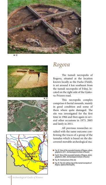
Rogova<br />
83<br />
84<br />
85<br />
The tumuli necropolis <strong>of</strong><br />
Rogova, situated at the location<br />
known locally as the Fusha (Field),<br />
is set around 4 km southeast from<br />
the tumuli necropolis <strong>of</strong> Fshej, located<br />
on the right side <strong>of</strong> the Gjakova-Prizren<br />
road.<br />
This necropolis complex<br />
comprises 6 burial mounds, mainly<br />
in good condition and some <strong>of</strong><br />
them where quite damaged. The<br />
site was investigated for the first<br />
time in 1966 and then again in several<br />
other occasions in 1973, 2005<br />
and lately in 2011.<br />
All previous researches resulted<br />
with the same outcome confirming<br />
the traces <strong>of</strong> a group <strong>of</strong> the<br />
tumulus which is based on the discovered<br />
movable archeological ma-<br />
Rogovo<br />
Fig. 82. View <strong>of</strong> the excavated tumulus <strong>of</strong> Rogova, photographed<br />
in 2011. (<strong>Archaeological</strong> Institute <strong>of</strong> <strong>Kosovo</strong>)<br />
Fig 83. View <strong>of</strong> the excavated tumulus <strong>of</strong> Rogova, photographed<br />
in 2005. (<strong>Archaeological</strong> Institute <strong>of</strong> <strong>Kosovo</strong>)<br />
Fig. 84. Aerial picture <strong>of</strong> the site<br />
Fig. 85. The site setting map <strong>of</strong> the tumuli necropolis <strong>of</strong><br />
Rogova, Gjakova Municipality.<br />
42 <strong>Archaeological</strong> <strong>Guide</strong> <strong>of</strong> <strong>Kosovo</strong>