Archaeological Guide of Kosovo
Archaeological Guide of Kosovo
Archaeological Guide of Kosovo

You also want an ePaper? Increase the reach of your titles
YUMPU automatically turns print PDFs into web optimized ePapers that Google loves.
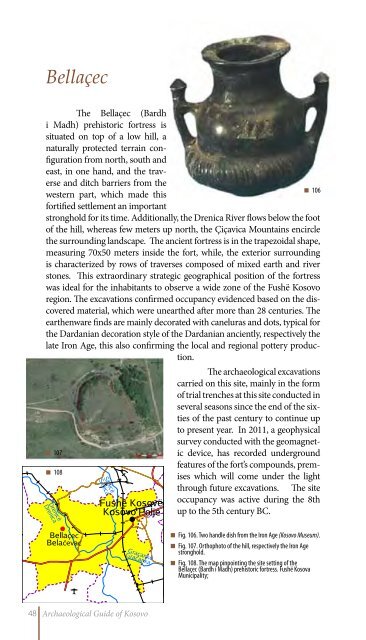
Bellaçec<br />
The Bellaçec (Bardh<br />
i Madh) prehistoric fortress is<br />
situated on top <strong>of</strong> a low hill, a<br />
naturally protected terrain configuration<br />
from north, south and<br />
east, in one hand, and the traverse<br />
and ditch barriers from the<br />
western part, which made this<br />
fortified settlement an important<br />
stronghold for its time. Additionally, the Drenica River flows below the foot<br />
<strong>of</strong> the hill, whereas few meters up north, the Çiçavica Mountains encircle<br />
the surrounding landscape. The ancient fortress is in the trapezoidal shape,<br />
measuring 70x50 meters inside the fort, while, the exterior surrounding<br />
is characterized by rows <strong>of</strong> traverses composed <strong>of</strong> mixed earth and river<br />
stones. This extraordinary strategic geographical position <strong>of</strong> the fortress<br />
was ideal for the inhabitants to observe a wide zone <strong>of</strong> the Fushë <strong>Kosovo</strong><br />
region. The excavations confirmed occupancy evidenced based on the discovered<br />
material, which were unearthed after more than 28 centuries. The<br />
earthenware finds are mainly decorated with caneluras and dots, typical for<br />
the Dardanian decoration style <strong>of</strong> the Dardanian anciently, respectively the<br />
late Iron Age, this also confirming the local and regional pottery production.<br />
107<br />
108<br />
106<br />
The archaeological excavations<br />
carried on this site, mainly in the form<br />
<strong>of</strong> trial trenches at this site conducted in<br />
several seasons since the end <strong>of</strong> the sixties<br />
<strong>of</strong> the past century to continue up<br />
to present year. In 2011, a geophysical<br />
survey conducted with the geomagnetic<br />
device, has recorded underground<br />
features <strong>of</strong> the fort’s compounds, premises<br />
which will come under the light<br />
through future excavations. The site<br />
occupancy was active during the 8th<br />
up to the 5th century BC.<br />
Fig. 106. Two handle dish from the Iron Age (<strong>Kosovo</strong> Museum).<br />
Fig. 107. Orthophoto <strong>of</strong> the hill, respectively the Iron Age<br />
stronghold.<br />
Fig. 108. The map pinpointing the site setting <strong>of</strong> the<br />
Bellaçec (Bardh i Madh) prehistoric fortress. Fushë Kosova<br />
Municipality;<br />
48 <strong>Archaeological</strong> <strong>Guide</strong> <strong>of</strong> <strong>Kosovo</strong>