ANOKA STATION PLAN - City of Anoka
ANOKA STATION PLAN - City of Anoka
ANOKA STATION PLAN - City of Anoka

Create successful ePaper yourself
Turn your PDF publications into a flip-book with our unique Google optimized e-Paper software.
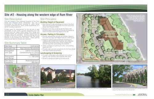
Site #2 - Housing along the western edge <strong>of</strong> Rum River<br />
Site Description<br />
This site located in the northeast quadrant <strong>of</strong> the Ferry<br />
Street and Pleasant Street intersection. This site is<br />
envisioned as high-density housing for either owner<br />
occupied condominiums, luxury rental apartments or a<br />
senior housing cooperative.<br />
Primary goals for development on the site are to take<br />
advantage <strong>of</strong> river views, provide separation from the<br />
housing and the heavy traffic along Ferry Street and<br />
Pleasant Street, and facilitate important community trail<br />
linkages along the perimeter. Surface parking lots are<br />
allowed in the front <strong>of</strong> the development with the broad<br />
setback <strong>of</strong> the building from the street. These parking<br />
areas should take on a street-like character.<br />
Site Summary Table:<br />
Site Area<br />
Intended Use<br />
Anticipated<br />
Unit Type<br />
Anticipated<br />
Unit Range<br />
Site Status /<br />
Availability<br />
4.24 Acres<br />
High Density Residential<br />
Owner Occupied<br />
Condominiums or Luxury<br />
Apartments<br />
+/- 100 Units<br />
Redevelopment /<br />
Mid-Term<br />
Site Principles:<br />
Building Height & Placement<br />
• Site building to take advantage <strong>of</strong> views <strong>of</strong> the Rum<br />
River and to provide separation from the busy Ferry<br />
Street and Pleasant Street.<br />
• Develop a 3-4 story building with the bulk <strong>of</strong> the<br />
building mass in the center <strong>of</strong> the site and stepping<br />
down in scale toward the edges <strong>of</strong> the site.<br />
Access, Parking & Circulation<br />
• Provide development access <strong>of</strong>f <strong>of</strong> Martin Street to<br />
the north and align with Maple Avenue on the South.<br />
• Organize surface parking between building and<br />
roadway with a street-like character with sidewalks<br />
leading to the primary entry <strong>of</strong> the building and<br />
connecting to the surrounding trail network.<br />
• Utilize underground parking for units - one parking<br />
space per unit.<br />
• Provide multi-use trail connections for the Ferry Street<br />
and North Street trail corridors.<br />
Landscaping & Screening<br />
• Provide a landscape buffer between the surface<br />
parking, trail corridors and Gateway Park area.<br />
• Screen underground parking access points.<br />
Ferry Street<br />
Multi-Use Trail<br />
(Ferry Street Corridor)<br />
Gateway<br />
Park<br />
Trail Connection<br />
Surface<br />
Parking<br />
Underground Parking<br />
Access<br />
Drop Off<br />
Condominiums<br />
Apartments<br />
+/- 100 units<br />
Surface<br />
Parking<br />
Views <strong>of</strong><br />
Rum River<br />
Preserve<br />
Woodland<br />
Edge Along<br />
River<br />
Underground Parking<br />
Access<br />
Multi-Use Trail (North Street Corridor)<br />
Pleasant Street<br />
This site is currently guided for<br />
commercial and low density<br />
residential in the <strong>City</strong>’s the<br />
Comprehensive Plan and on the<br />
<strong>City</strong>’s Zoning Map.<br />
Site<br />
2<br />
Site Location.<br />
The building should take advantage <strong>of</strong> river views and provide separation<br />
from the busy roadways surrounding the site.<br />
The views <strong>of</strong> the Rum River provide a tremendous asset to the site.<br />
Surface parking lots should be well landscaped from perimeter streets and<br />
designed as internal streets for the development.<br />
24 <strong>Anoka</strong> Station Plan<br />
Hoisington Koegler Group Inc.