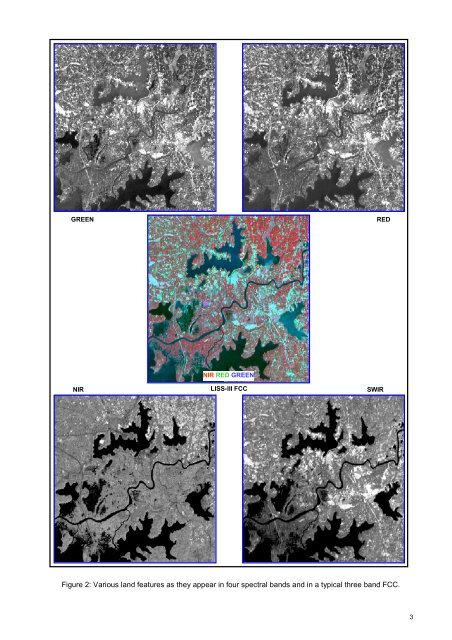
now recognized as an essential tool for viewing, analyzing, characterizing, <strong>and</strong> making decisions about l<strong>and</strong>, water <strong>and</strong> atmospheric components. From a general perspective, remote sensing is the science <strong>of</strong> acquiring <strong>and</strong> analyzing information about objects or phenomena from a distance (Jensen, 1986; Lilles<strong>and</strong> <strong>and</strong> Keifer, 1987). Today, we define satellite remote sensing as the use <strong>of</strong> satellite borne sensors to observe, measure, <strong>and</strong> record the electromagnetic radiation (EMR) reflected or emitted by the earth <strong>and</strong> its environment for subsequent analysis <strong>and</strong> extraction <strong>of</strong> information. EMR sensors includes visible light, near-, mid- <strong>and</strong> far-infrared (thermal), microwave, <strong>and</strong> long-wave radio energy. The capability <strong>of</strong> multiple sources <strong>of</strong> information is unique to remote sensing. Of specific advantage is the spectral, temporal, <strong>and</strong> spatial resolution. Spectral resolution refers to the width or range <strong>of</strong> each spectral b<strong>and</strong> being recorded. Since each target affects different wavelengths <strong>of</strong> incident energy differently, they are absorbed, reflected or transmitted in different proportions. Currently, there are many l<strong>and</strong> resource remote sensing satellites that have sensors operating in the green, red, near infrared <strong>and</strong> short wave Infra red regions <strong>of</strong> the electromagnetic spectrum giving a definite spectral signature <strong>of</strong> various targets due to difference in radiation absorption <strong>and</strong> reflectance <strong>of</strong> targets. These sensors are <strong>of</strong> common use for l<strong>and</strong> cover studies, including wetl<strong>and</strong>s. Figure 1 shows typical spectral signature <strong>of</strong> few targets from green to SWIR region. Converted to image, in a typical false colour composite (FCC) created using NIR, red <strong>and</strong> green b<strong>and</strong>s assigned as red, green <strong>and</strong> blue colour, the features become very distinct as shown in Figure 2. In FCC, the vegetation thus appears invariably red (due to high reflection in NIR from green leaves). Since the early 1960s, numerous satellite sensors have been launched into orbit to observe <strong>and</strong> monitor the earth <strong>and</strong> its environment. Most early satellite sensors acquired data for meteorological purposes. The advent <strong>of</strong> earth resources satellite sensors (those with a primary objective <strong>of</strong> mapping <strong>and</strong> monitoring l<strong>and</strong> cover) occurred, when the first L<strong>and</strong>sat satellite was launched in July 1972. Currently, more than a dozen orbiting satellites <strong>of</strong> various types provide data crucial to improving our knowledge <strong>of</strong> the earth’s atmosphere, oceans, ice <strong>and</strong> snow, <strong>and</strong> l<strong>and</strong>. Of particular interest to India is the indigenous series <strong>of</strong> satellites called Indian Remote Sensing satellites (IRS-Series). Since the launch <strong>of</strong> the first satellite IRS 1A in 1987, India has now a number <strong>of</strong> satellites providing data in multi-spectral b<strong>and</strong>s with different spatial resolution. IRS P6/RESOURCESAT 1 is the current generation satellite that provides multi-spectral images in spatial resolution <strong>of</strong> 5.8 m (LISS IV), 23.5 m (LISS III) <strong>and</strong> 56m (AWiFS). Over the past few decades, Indian remote sensing data has been successfully used in various fields <strong>of</strong> natural resources ( Navalgund et al. 2002 ). Development <strong>of</strong> technologies like Geographic Information System (GIS) has enhanced the use <strong>of</strong> RS data to obtain accurate geospatial database. GIS specialises in h<strong>and</strong>ling related, spatially referenced data, combining mapped information with other data <strong>and</strong> acts as analytical tool for research <strong>and</strong> decision making. During the past few decades, technological advances in the field <strong>of</strong> satellite remote sensing (RS) sensors, computerized mapping techniques, global positioning system (GPS) <strong>and</strong> geographic information system (GIS) has enhanced the ability to capture more detailed <strong>and</strong> timely information about the natural resources at various scales catering to local, regional, national <strong>and</strong> global level study. Figure 1: Spectral Signature <strong>of</strong> various targets 2
GREEN RED NIR NIR RED GREEN LISS-III FCC SWIR Figure 2: Various l<strong>and</strong> features as they appear in four spectral b<strong>and</strong>s <strong>and</strong> in a typical three b<strong>and</strong> FCC. 3