
Create successful ePaper yourself
Turn your PDF publications into a flip-book with our unique Google optimized e-Paper software.
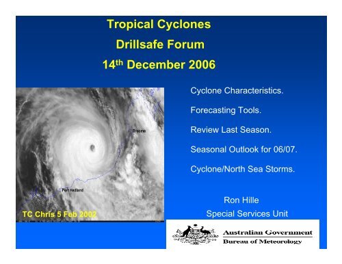
Tropical <strong>Cyclone</strong>s<br />
Drillsafe Forum<br />
14 th December 2006<br />
<strong>Cyclone</strong> Characteristics.<br />
Forecasting Tools.<br />
Review Last <strong>Season</strong>.<br />
<strong>Season</strong>al Outlook for 06/07.<br />
<strong>Cyclone</strong>/North Sea Storms.<br />
TC Chris 5 Feb 2002<br />
Ron Hille<br />
Special Services Unit
What is a tropical cyclone ?<br />
What is a tropical cyclone ?<br />
• Tropical low pressure<br />
system<br />
• Clockwise winds ><br />
63km/h (gales)<br />
Very destructive winds<br />
Very destructive winds<br />
Tropical low pressure system<br />
Clockwise winds > 63km/h (gales)<br />
Hurricane Isobel 2003
All TCs are unique<br />
Vary according to:<br />
• Intensity & life cycle<br />
• Movement<br />
•Size<br />
Hazard<br />
• Rainfall and flooding<br />
• Storm surge<br />
•Wind<br />
• Sea State
Tropical <strong>Cyclone</strong> Intensity Scale<br />
Cat. Strongest gust Impact<br />
No. (km/h) (aside from rain)<br />
1 < 125<br />
“Damaging” winds Minor<br />
2 125-169<br />
“Destructive” winds Moderate<br />
3 170-224<br />
4 225-279<br />
5 > 279<br />
SEVERE<br />
“Very destructive”<br />
winds<br />
Major Monty<br />
EXTREME Vance
All TCs are unique - Size
Darwin – a low risk location
All TCs are unique - intensity
All TCs are unique - Movement
Where will it go? The ‘ensemble’ forecast
Accuracy - Perth TCWC 1984-2004
<strong>Season</strong> Accuracy
Winds:What is a category 4 like?
Karratha Vs Dampier Winds
Storm Surge<br />
BREAKER ZONE<br />
Storm Surge<br />
DUNE<br />
100 M<br />
mound of water produced by<br />
MEAN TIDE<br />
(MSL)<br />
• winds piling water against the shore<br />
• the low pressure of the cyclone.
TC Vance Storm Surge
TC Vance Storm surge - west of Onslow
Storm Surge: Advice based on Worst Case<br />
Scenario
A cyclone<br />
TROPICAL CYCLONE Warning Number 3<br />
Issued at 3:00 am WST on Sunday, 8<br />
January 2006<br />
BY THE SPECIAL SERVICES UNIT OF<br />
THE BUREAU OF METEOROLOGY for<br />
Clients operating in the Timor Sea, Pilbara<br />
and Offshore region.<br />
At 2:00 am WST TROPICAL CYCLONE<br />
CLARE was located …<br />
Significant Threat of a SEVERE CYCLONE impacting on<br />
Facilities Offshore Pilbara and along the Pilbara coast.<br />
Industry on high alert. Preparations for Offshore Evacuations.
Detailed TC Forecasts Issued<br />
6 Hourly When TC Within 600nm of NRA &<br />
3 hourly when TC Within 400nm.
Assessing the risk/likelihood<br />
Likelihood of a cyclone impact<br />
• Long-term: historical records<br />
• <strong>Season</strong>al: ENSO, ocean temperatures<br />
• Monthly: quiet and active times in the<br />
wet/TC season<br />
• Few days to hours: life of individual cyclone
Likelihood – Long-term records<br />
TC crossings – Severe & non-severe
Likelihood – Long-term records
• Text here
How Good was the <strong>Season</strong>al Outlook?<br />
2005-06 season
2004-05 season
Category 5 Severe TC Monica<br />
24 th April 2006<br />
Severe TC Monica most intense cyclone observed over NT region<br />
Estimated Sustained Max winds 135kn – 155mph - 250km/h<br />
Estimated Maximum gusts 250kn – 287mph - 350km/h
Junction Bay on NT coast after passage of<br />
Severe TC Monica. Trees totally defoliated.
Review the 2005/06 <strong>Cyclone</strong> Outlook<br />
for North West Australia<br />
• Numbers of cyclones<br />
likely to be about<br />
average (5).<br />
• Likelihood of around 2<br />
coastal impacts.<br />
• Significant risk of a<br />
severe coastal impact.<br />
• 6 – above average<br />
• 4 coastal impacts<br />
Clare, Emma, Glenda, Hubert<br />
• 2 - Clare and Glenda<br />
(just cat 3)<br />
• Most active period<br />
more likely in<br />
Jan/Feb.<br />
• Jan Clare & Daryl<br />
March Floyd & Glenda.
Developing El Nino –<br />
Pacific Sea Surface Temperatures
The 2006/07 Tropical <strong>Cyclone</strong> Outlook<br />
for North West Australia<br />
• About 4 cyclones expected in waters off the<br />
NW coast (average is 5).<br />
• 1-22 coastal impacts.<br />
• Significant risk of a severe coastal impact.<br />
• Lower than normal risk of a cyclone before<br />
Christmas. More likely to impact Kimberley<br />
or Eighty mile beach.<br />
• Not likely to have as many on Pilbara coast<br />
as last season!
Outlook for 2006/2007 Tropical <strong>Cyclone</strong><br />
<strong>Season</strong><br />
for the Northern Region<br />
• an early cyclone in November or early December) is less likely<br />
this year<br />
• cyclone activity more likely in Gulf of Carpentaria<br />
• around 60% chance of a severe tropical cyclone<br />
(category 3 or greater)<br />
• if a severe cyclone forms, it is more likely to affect the Gulf of<br />
Carpentaria<br />
• it is likely that at least one tropical cyclone will form in the<br />
Northern Region, with a 60% chance of 2 to 3 cyclones
The Likelihood: 2-6 weeks<br />
Active periods<br />
Quiet periods<br />
(Breaks)<br />
2004-05 season
Comparison Severe Tropical <strong>Cyclone</strong>s &<br />
Intense North Sea Storms<br />
• Sustained Max winds of high C4 & C5 cyclones >= 100knots.<br />
• Sustained Max winds intense Nth Sea Storms up to 75knots, extremes to 97 knots.<br />
• Max winds of cyclones concentrated just inside eye wall.<br />
Very Destructive winds usually less than 100km from cyclone centre.<br />
• A least one cyclone has reached a max sustained winds of 97knots or more<br />
every season over past 10 yrs. ( 97 knots 10,000yr return period for Norwegian<br />
Shelf storms)<br />
. Due to higher background swells and larger fetch areas of Nth Sea a storms, the 100yr<br />
return period for offshore Pilbara and Nth Sea region are very similar ( Hs 12 - 15m).<br />
. <strong>Cyclone</strong> tracks can be much more erratic than Nth Sea depressions.
El Nino and TC’s
El Nino and TC’s