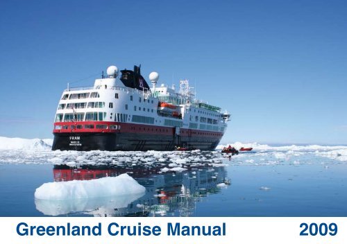
Greenland Cruise Manual 2009 - Blue Water Shipping
Greenland Cruise Manual 2009 - Blue Water Shipping
Greenland Cruise Manual 2009 - Blue Water Shipping

You also want an ePaper? Increase the reach of your titles
YUMPU automatically turns print PDFs into web optimized ePapers that Google loves.
<strong>Greenland</strong> <strong>Cruise</strong> <strong>Manual</strong> <strong>2009</strong>
<strong>Greenland</strong> <strong>Cruise</strong> <strong>Manual</strong> ®<br />
© CB Reklame, 2008<br />
Published on behalf of <strong>Greenland</strong> Tourism & Business Council<br />
Editor<br />
<strong>Greenland</strong> Tourism & Business Council<br />
Fact Sheet Source<br />
Royal Arctic Liner Agency<br />
Graphic preparation and production<br />
CB Reklame - www.reklame.gl<br />
Photos<br />
CB, Manfred Horender, Karsten Bidstrup, Kristjan Fridriksson, Lars Reimers, <strong>Greenland</strong> Tourism,<br />
Wedigo Ferchland.
Contents<br />
<strong>Cruise</strong> <strong>Greenland</strong> ...........................................................................................................4<br />
Ilulissat Icefjord - World Heritage Site.................................................................6<br />
Inuit and Vikings.................................................................................................................8<br />
A recipe for a succesfull call ...................................................................................11<br />
Nature Protection and Cultural History......................................................... 12<br />
Safety in Arctic <strong>Water</strong>s..............................................................................................14<br />
Arts and Crafts..............................................................................................................15<br />
Destinations in <strong>Greenland</strong>.......................................................................................17<br />
Distances in the North Atlantic...........................................................................36<br />
Port Agents and Partners........................................................................................37<br />
Practical Information...................................................................................................56
<strong>Cruise</strong> <strong>Greenland</strong> <strong>2009</strong><br />
<strong>Cruise</strong> the Arctic<br />
<strong>Greenland</strong> is the world’s largest island with a population of only 56.500, distributed<br />
among 17 towns and some 60 settlements, none of which are connected by roads.<br />
This makes <strong>Greenland</strong> a different cruise destination, where genuine experiences<br />
by far outweigh more traditional cruise port services.<br />
Even though the size of local ports limits facilities, the small communities,<br />
magnificent scenery and hospitable population is guaranteed to make your visit to<br />
<strong>Greenland</strong> truly original and memorable.<br />
Thus in recent years, we have met with a constantly increasing interest in adding<br />
<strong>Greenland</strong> to the range of cruising itineraries with annual growth rates of up to<br />
30-40%. There are many good reasons for this trend:<br />
· <strong>Greenland</strong> is distinct and genuine<br />
<strong>Greenland</strong> is a destination containing the qualities in demand by today’s cruising<br />
world: Distinctiveness in nature and culture, unique scenery, a vivid local culture,<br />
fascinating wildlife, an exclusive realm of pure experience shared only by a very<br />
select group of people.<br />
· Combining destinations<br />
<strong>Greenland</strong> is ideally situated halfway between Iceland and North America, and is<br />
the obvious inclusion to a North Atlantic cruise. Offering nature and culture so<br />
different from other destinations in the region, <strong>Greenland</strong> will help perfect your<br />
itinerary.<br />
You may also want to combine <strong>Greenland</strong> with Iceland, the Faroe Islands and/or<br />
Arctic Canada for the tour to be designed with a particular theme in view, e.g. the<br />
history of Eric the Red and the Norse (Vikings), or the nature, life and cultures of<br />
the North Atlantic.<br />
· Unique Arctic nature<br />
<strong>Greenland</strong> embodies the very concept of the Arctic, making it the natural<br />
Northern Atlantic destination for cruise operators. The interior is formed by an<br />
enormous ice cap, second only to the ice cap of the Antarctic. Recently the Ilulissat<br />
Icefjord was proclaimed a World Heritage site due to its exceptional qualities.<br />
Situated practically en route from Europe to North America, <strong>Greenland</strong> offers<br />
easy access to a genuine Arctic experience.<br />
· Midnight sun and icebergs<br />
Towering icebergs aglow in the midnight sun can be experienced in very few<br />
other places.<br />
· A secure destination<br />
<strong>Greenland</strong> and the North Atlantic are safe places to travel. Along with the fact<br />
that all airports and harbors conform to international Security Regulations,<br />
<strong>Greenland</strong>ers are well-known for their peaceful manners in a country that has<br />
never been engaged in warfare.<br />
Kalaallit Nunaannut tikilluaritsi – Welcome to <strong>Greenland</strong>
Ilulissat Icefjord – World Heritage Site<br />
Located on the west coast of <strong>Greenland</strong>, 300 km north of the Arctic Circle,<br />
<strong>Greenland</strong>’s Ilulissat Icefjord is the sea mouth of Sermeq Kujalleq, one of few<br />
glaciers through which the <strong>Greenland</strong> ice sheet reaches the sea.<br />
Sermeq Kujalleq is one of the fastest (40-m per day) and most active glaciers in<br />
the world. Its annual calving corresponds to over 70 km3 of ice, i.e. 10% of the<br />
production of all <strong>Greenland</strong> calf ice and more than any other glacier outside<br />
Antarctica. Studied for over 250 years, it has helped develop our understanding<br />
of climate change and ice cap glaciology.<br />
The combination of a huge ice-sheet and the dramatic sounds of a fast-moving<br />
glacial ice-stream calving into a fjord covered by icebergs makes for a dramatic<br />
and awe-inspiring natural phenomenon.<br />
The Ilulissat Icefjord is a UNESCO World Heritage site since 2004 and is<br />
protected by <strong>Greenland</strong>ic law.<br />
A natural treasure to protect<br />
The <strong>Greenland</strong> Home Rule statuary order nr. 10 of June 15th 2007 states that it<br />
is forbidden to damage vegetation or terrain, and to pollute lakes, creeks, fjords,<br />
glaciers or areas in any way within the protected area.<br />
The archeological site of Sermermiut is also protected, and it is not allowed to<br />
damage or remove any objects from the site. In order not to damage the site,<br />
Sermermiut should only be accessed from the town of Ilulissat, as landings from<br />
the Icefjord lead to erosion.<br />
It is only permitted to carry out tourist sailing trips within the protected area<br />
using guides with knowledge of <strong>Greenland</strong>’s nature and legislation concerning<br />
nature conservation (sub-area C – the outermost marine part of the Icefjord).<br />
Sailing within the mouth of the fjord (sub-area C) with vessels greater than<br />
1000 Gross Registered Tonnes (GRT) is not permitted.
Tourist sailing trips in the inner parts of the fjord (sub-area B – the innermost<br />
marine part of the Icefjord) are not permitted.<br />
The landing of tourists is also prohibited throughout the Icefjord. Violations are<br />
liable to result in financial penalty.<br />
Please consult the complete statutory order on preservation, which is available<br />
in English at the address: www.greenland.com/icefjord-preservation
Inuit and Vikings<br />
Millenia of Myth and Saga<br />
Hunters of the North<br />
The first traces of people in <strong>Greenland</strong> date back to 2500 BC, when hunters<br />
followed the trail of musk oxen from North America to <strong>Greenland</strong>. These early<br />
cultures developed sophisticated tools and ways of living which enabled them as<br />
the first people to withstand the extreme Arctic climate on a permanent basis.<br />
About a 1.000 years ago Inuit – the human beings – brought the Thule culture<br />
from the Bering Strait to <strong>Greenland</strong> with techniques and technology that is still in<br />
use today – the kayak, the dog sledge, the harpoon.<br />
During the long winter nights a vivid mythical world would come alive through<br />
storytelling, drum dancing and carvings. Did you for instance know, that all sea<br />
mammals nest in the hair of The Mother of the Sea”? And that every time a person<br />
does wrong, her hair will filter and eventually all the animals will be trapped. In the<br />
old days this meant hunger if a skilled shaman did not succeed in finding her house<br />
and comb her hair to set the animals free!<br />
Vikings of the Arctic<br />
About the same time that the Inuit started their journey from the Bering Strait to<br />
<strong>Greenland</strong>, a young Viking called Erik the Red led a group of settlers from Iceland<br />
to South <strong>Greenland</strong> and founded the Norse settlements in <strong>Greenland</strong>. It was<br />
from this starting point that Leif Eriksson, son of Erik, discovered, explored and<br />
overwintered in North America as the first European.<br />
The Norse formed a society in <strong>Greenland</strong> that lasted 500 years on farming, fishing<br />
and hunting. They build the first Christian church in the Western Hemisphere,<br />
explored the high Arctic and harvested wood from North America. Around 1480<br />
AD they disappeared, leaving only ruins and remains and the mystery of what<br />
really happened.<br />
Today <strong>Greenland</strong>ic sheep farmers have resettled on the Norse farmland, using the<br />
same fields that were cleared by Vikings a 1000 years ago!
A recipe for a succesful call<br />
How to make the most of a visit to <strong>Greenland</strong><br />
The call of a cruise ship to a <strong>Greenland</strong> port is always a welcome and happy<br />
occasion. Locals find both the ships and their passengers interesting. However in<br />
order to make your call truly successful it is important that ship, incoming agency,<br />
port agent and local authorities work in close collaboration.<br />
In <strong>Greenland</strong>, towns and settlements are small – even the capital Nuuk has no<br />
more than 14.000 inhabitants. It is important to realize, that in many settlements<br />
it is a substantial part of the population who are involved when a cruise ship<br />
arrives. Local capacity is often stretched to its limits in order to service you and<br />
your passengers. It is necessary to take this into consideration when planning the<br />
duration of your call. A few extra hours in port may be just that, which turns your<br />
call into a rich experience for all your passengers.<br />
Therefore it is also crucial, that the local destination is informed of your call well<br />
in advance, either directly or through your incoming agent, in order to advise<br />
you regarding logistics and possibilities. Even more important is subsequent and<br />
continuous information on deviations from schedule, as this often implies huge<br />
logistical challenges to the local organizers.<br />
The better the local organizers are informed, the better they can prepare to make<br />
your call memorable. Also make sure, that information from the local organizers<br />
on possible program changes or practical information is channeled to the right<br />
persons onboard, so your passengers may also be well prepared for the call.<br />
11
Nature Protection and Cultural History<br />
Announcement from<br />
The Ministry of Environment and Nature<br />
The Arctic is fragile, vast and beautiful with pristine spaces and extreme climate,<br />
and a wealth of natural resources. It is the permanent home of both highly<br />
developed living organisms and, during the short summer, the temporary home<br />
for scores of migratory species of sea-mammals and birds.<br />
At the same time all Arctic ecosystems are characterized by simple food chains<br />
and relatively slow ecological processes with limited resilience and very long<br />
recovery time from human disturbances.<br />
Therefore it is extremely important to take precautions not to disturb<br />
unnecessarily<br />
or leave anything behind but footprints.<br />
Among the most important legislation to be aware of is:<br />
• Landsting Act no. 29 of 2003 on the Protection of Nature<br />
• Executive order no. 1 of 2004 on Bird protection<br />
• Executive orders no. 7 of 1992 and no. 16 of 1999 on the National Park<br />
• Executive order no. 7 of 2003 on the protection of Ilulissat Ice Fjord<br />
Contact:<br />
The Ministry of Environment and Nature<br />
P.O. Box 1614, DK-3900 Nuuk, <strong>Greenland</strong><br />
Ph.: +299 346701, Fax: +299 325286<br />
app-dmn@gh.gl, www.nanoq.gl/dmn.<br />
Announcement from<br />
The <strong>Greenland</strong> National Museum & Archives<br />
The <strong>Greenland</strong>ic Act of Preservation of Cultural History severely forbids any kind<br />
of violation of man-made monuments such as graves, ruins, hunting structures<br />
as well as structures from recent times protected by preservation regulations.<br />
Collecting items from protected areas are under all circumstances prohibited.<br />
Furthermore, it is stressed that cemeteries in abandoned settlements are<br />
protected by law. Violation of graves by collection of souvenirs such as bones, part<br />
of headstones, whole headstones a.s.o. is strictly prohibited. Violation of these acts<br />
is a criminal act and subject to penalty .<br />
We strongly urge all cruise vessels to provide their passengers with guidelines and<br />
a code of conduct based on the above when visiting abandoned settlements and<br />
other historic sites in <strong>Greenland</strong> and help prevent any behavior that harms the<br />
site. Help us preserve the unique cultural history of <strong>Greenland</strong>.<br />
Contact:<br />
<strong>Greenland</strong> National Museum and Archives<br />
P.O. Box 145, DK-3900 Nuuk, <strong>Greenland</strong><br />
Ph.: +299 322611, Fax: +299 322622<br />
E-mail: nka@natmus.gl, www.natmus,gl<br />
12
Safety in Arctic waters<br />
Warning against the use of Zodiacs and dinghies near icebergs and glaciers in <strong>Greenland</strong><br />
In a number of incidents zodiacs and dinghies have been used by cruise vessels<br />
to take passengers close to icebergs and glacier sheets in <strong>Greenland</strong>. We must<br />
stress that such excursions may endanger the lives of passengers and crew.<br />
Over the past few years there have been several incidents in which calving<br />
icebergs and glaciers - and their resulting tidal waves have caused boats to<br />
capsize.<br />
For cruise vessels which, despite this caution, intend to continue the<br />
abovementioned practices we urge that passengers be duly notified of the<br />
inherent risks.<br />
<strong>Greenland</strong> Tourism – The National Tourist Board of <strong>Greenland</strong>.<br />
We therefore strongly urge that all boat excursions be carried out by certified<br />
passenger vessels, whose crews have extensive knowledge of the area and of<br />
the ice. There is a number of certified boats available for bookings in Ilulissat<br />
and other towns. Please contact the local tourist office or your incoming agent<br />
for details.<br />
14
Arts and Crafts<br />
Handicrafts developed through generations<br />
Much-coveted <strong>Greenland</strong> souvenirs are figures cut out of bone or soapstone:<br />
so-called Tupilaks. The Tupilak was originally a spirit. Symbolic creations of these<br />
spirits were made by people with supernatural powers, in the sole purpose of<br />
killing or hurting their own or other people’s enemies. However, the Tupilak would<br />
unfortunately turn on the sender if his motives were impure, or if the intended<br />
victim possessed even stronger magical powers. Today, <strong>Greenland</strong>ic artists such<br />
as painters, musicians and actors find inspiration in the myths and legends of the<br />
past in exiting expressions, often combining the new and old world. The colorful<br />
<strong>Greenland</strong>ic national costume with its characteristic beaded collar is still worn at<br />
festivities and at other cultural or religious celebrations.<br />
15
Destinations in <strong>Greenland</strong><br />
Qaanaaq<br />
Recommended<br />
approx. no. of pax<br />
M (501-1200)<br />
Selected ports<br />
Nanortalik.....................................18<br />
Qaqortoq......................................19<br />
Nuuk.............................................20<br />
Sisimiut........................................21<br />
Ilulissat.........................................22<br />
Upernavik<br />
S (201-500)<br />
Narsaq.........................................23<br />
Aasiaat.........................................24<br />
Tasiilaq/Ammassalik.....................25<br />
Uummannaq<br />
Ittoqqortoormiit<br />
Qeqertarsuaq<br />
Aasiaat<br />
Sisimiut<br />
Maniitsoq<br />
Ilulissat<br />
Qasigiannguit<br />
Kangerlussuaq<br />
Tasiilaq<br />
Arctic Circle 66º 33'<br />
XS (0-200)<br />
Paamiut........................................26<br />
Maniitsoq......................................27<br />
Qasigiannguit...............................28<br />
Qeqertarsuaq...............................29<br />
Uummannaq/Ukkusissat..............30<br />
Upernavik.....................................31<br />
Qaanaaq......................................32<br />
Ittoqqortoormiit.............................33<br />
Nuuk<br />
Paamiut<br />
Qaqortoq<br />
Nanortalik<br />
Narsarsuaq<br />
Narsaq<br />
International airports with<br />
port access<br />
Narsarsuaq..................................34<br />
Kangerlussuaq.............................35<br />
17
Nanortalik<br />
M (501-1200)<br />
60°08’N / 50°45’14’’W<br />
About<br />
Nanortalik is <strong>Greenland</strong>’s southernmost town, located in an area with rugged<br />
mountain peaks and deep fjords that is a paradise for mountain climbing. The<br />
name Nanortalik means ”the place where the polar bears go”, referring to the<br />
polar bears that drift down with the pack ice from the East Coast each spring. The<br />
town’s open-air museum features exhibits on Inuit and Norse culture and life in<br />
the colonial days. A visit to Nanortalik usually includes a ”Kaffemik” – a traditional<br />
festive event with coffee, tea and homemade cakes. Guests are entertained by<br />
local dancers and have an opportunity to visit the church and listen to the choir.<br />
At a kayak show, spectators can also marvel at how centuries of knowledge and<br />
skill are still alive and well in Nanortalik, a community where traditional hunting<br />
and fishing remain an essential part of everyday life.<br />
Fact sheet<br />
Location:<br />
Ice condition:<br />
Pier:<br />
Safe anchorage:<br />
Fresh water supply:<br />
Local time:<br />
60°08’N / 50°45’14’’W<br />
Pack ice in May/June, icebergs are common.<br />
Atlantic Quay, Length 30 m, depth 3 m<br />
60°18’N / 45°5’W<br />
No<br />
GMT -3 hours<br />
18
Qaqortoq<br />
M (501-1200)<br />
60°43’N / 46°02’W<br />
About<br />
Qaqortoq means ”The white”. It was founded in 1775 and is today the largest<br />
town in South <strong>Greenland</strong> with more than 3.500 inhabitants. 3.200 live in the town<br />
itself, while the rest live in the three surrounding settlements, on two reindeer<br />
farms and at 13 sheep farms.<br />
The town square with <strong>Greenland</strong>’s oldest fountain is situated close to the harbor<br />
where the fishermen arrive every day with the day’s catch on board. The square<br />
is encircled by well preserved buildings from the colonial era, the oldest of<br />
which were built more than 200 years ago. Several of these buildings still play an<br />
important role in the town’s daily life where old and new prosper side by side.<br />
Throughout Qaqortoq you meet examples of the unique art project “Stone and<br />
Man”. Scandinavian sculptors have contributed pieces of art chiseled in granite<br />
that transform the town into one big sculpture park.<br />
Fact sheet<br />
Location:<br />
Ice condition:<br />
Pier:<br />
Safe anchorage:<br />
Fresh water supply:<br />
Local time:<br />
60°43’N / 46°02’W<br />
Field ice may occur in May/June at fjord or outer harbour<br />
entrance. Glacier ice likely.<br />
Atlantic Quay. Length 100 m, depth 6,8 m<br />
60°42’765”N / 46°02’307’’W (muddy/rocky sea bottom)<br />
Yes<br />
GMT -3 hours<br />
Mean temperatures<br />
June July August September<br />
C°<br />
F°<br />
5.2 7.2 7.2 5.0<br />
41 45 45 41<br />
Source: DMI<br />
19
Nuuk<br />
M (501-1200)<br />
64°10’N/51°43’W<br />
About<br />
Nuuk means “The Cape”, an accurate description of its location on the tip of a<br />
large peninsula at the mouth of the spectacular Godthaab Fjord system.<br />
Nuuk is the capital and with some 15.300 inhabitants by far the largest town<br />
in <strong>Greenland</strong>. It is also the oldest town, founded in 1728 by “the apostle of<br />
<strong>Greenland</strong>” Hans Egede, a Danish-Norwegian missionary.<br />
Nuuk is a curious mix of a traditional <strong>Greenland</strong>ic town and a modern small<br />
capital. Within walking distance from the Old Harbour with it’s 19th century<br />
buildings and the local market where hunters and fishermen sell today’s catch you<br />
will find yourself in a modern town centre with young people dressed in the latest<br />
fashion and modern shops.<br />
Nuuk is the home of The National Museum of <strong>Greenland</strong>, <strong>Greenland</strong>’s Home Rule<br />
Government and many administrative bodies and companies hold offices here.<br />
Fact sheet<br />
Location:<br />
64°10’N/ 51°43’W<br />
Ice condition: Occasional glacier ice.<br />
Pier 1:<br />
Atlantic Quay. Length 100 m, depth 10 m<br />
Pier 2: Schooner Quay. Length 45, depth 10<br />
Safe anchorage: 64° 10’N/51° 45’70’’W<br />
64° 10’N/51° 42’30’’W<br />
64° 08’N/51° W<br />
Fresh water supply: Yes<br />
Local time: GMT -3 hours<br />
Mean temperatures<br />
June July August September<br />
C°<br />
F°<br />
3.9 6.5 6.1 3.5<br />
39 44 43 38<br />
Source: DMI<br />
20
Sisimiut<br />
M (501-1200)<br />
66º56,5’N / 53º40,5’W<br />
About<br />
Sisimiut means “the ones who live near the fox’s den”. The town is the second<br />
largest in <strong>Greenland</strong> with some 5.300 inhabitants and is beautifully situated<br />
surrounded by deep inlets, mountains and green fields. Characteristic for the area<br />
are the colorful wooden houses and the old colonial buildings from the 19th<br />
century.<br />
The earliest signs of human activity in Sisimiut dates back 4.500 years and for the<br />
archeologically interested visitor there are plenty of opportunities at the museum<br />
to learn how people lived in prehistoric times. The old part of the town is located<br />
at the center of Sisimiut and gives the visitor a charming historical view into the<br />
atmosphere of <strong>Greenland</strong> in the 19th and early 20th centuries.<br />
Itilleq<br />
Itilleq is a settlement in the municipality of Sisimiut, frequently visited by smaller<br />
cruise ships. It is located right on the Arctic Circle, making it the southernmost<br />
place for midnight sun in <strong>Greenland</strong>. It is also the southernmost point for dog<br />
sledding in <strong>Greenland</strong>. The settlement has approx. 140 inhabitants, living primarily<br />
of hunting for caribou and musk oxen and fishing.<br />
Fact sheet<br />
Location:<br />
Ice condition:<br />
Pier:<br />
Safe anchorage:<br />
Fresh water supply:<br />
Local time:<br />
66°56,5’N / 53°40,5’W<br />
Ice free all year round<br />
Atlantic Quay. Length 60 m, depth 7,8 m<br />
66°56’42’’N / 53°41’35’’W<br />
66°56’46’’N / 53°40’70’’W<br />
66°56’37’’N / 53°41’22’’W due to pipeline<br />
Yes<br />
GMT -3 hours<br />
Mean temperatures<br />
June July August September<br />
C°<br />
F°<br />
3.6 6.3 6.1 3.2<br />
39 43 43 38<br />
Source: DMI<br />
21
Ilulissat<br />
M (501-1200)<br />
69°13’N / 51°06’W<br />
About<br />
Icebergs are called ‘Ilulissat’ in <strong>Greenland</strong>ic, and it comes as no surprise to anyone<br />
who has been here that this is the town’s name. Ilulissat is beautifully situated at<br />
the mouth of the 56-kilometre ice fjord filled with enormous icebergs from the<br />
most productive glacier in the northern hemisphere. The largest icebergs strand<br />
at the mouth - at depths of 250 to 300 meters - and do not break free until<br />
the next spring tide, or until they are so eroded that their balance shifts. For its<br />
unique glaciology and unsurpassed natural splendor the Ilulissat Icefjord was in<br />
2004 inscribed to the UNESCO World Heritage List.<br />
4,500 people live in Ilulissat, and with them: thousands of sled dogs. This is an<br />
eloquent statement of the importance of the dogsled as a means of transport,<br />
even in a large modern town. The harbor is full of fishing vessels and trawlers that<br />
all bear witness to the great importance of fishing to the town.<br />
Just a few kilometers from the town you find the archeological site of Sermermiut<br />
valley that extends down to the ice fjord. 300 years ago, this was the site of<br />
<strong>Greenland</strong>’s largest settlement, then 250 people. Later excavations have shown<br />
that the beautiful valley has actually been inhabited for thousands of years.<br />
Fact sheet<br />
Location:<br />
Ice condition:<br />
Pier:<br />
Safe anchorage:<br />
Fresh water supply:<br />
Local time:<br />
69°13’N / 51°06’W<br />
Ice free June-December<br />
Atlantic Quay. Length 115 m, depth 7 m<br />
69°13’02’’N / 51°06’96’’W<br />
69°13’73’’N / 51°07’24’’W<br />
69°13’66’’N / 51°06’95’’W<br />
Yes<br />
GMT -3 hours<br />
Mean temperatures<br />
June July August September<br />
C°<br />
F°<br />
5.1 7.5 5.9 2.4<br />
41 46 43 36<br />
Source: DMI<br />
22
Narsaq<br />
S (201-500)<br />
60°54’N / 43°03’W<br />
About<br />
Narsaq means ‘the plain’ and was in accordance with <strong>Greenland</strong>ic tradition named<br />
after its scenic surroundings just in front of the characteristic Mt. Qaqqarsuaq.<br />
It is truly not without reason that Narsaq is often referred to as “the Pearl of<br />
<strong>Greenland</strong>”. The unique location of the town deep into the fjord system has<br />
presented Narsaq with a gentle sub-arctic climate allowing agriculture. The deepgreen<br />
valleys present an astonishing contrast to the blue-green icebergs passing by.<br />
From Narsaq town it is possible to see the <strong>Greenland</strong> ice cap.<br />
In 985 AD Vikings led by Erik the Red settled the Narsaq area, and lived of sheepbreeding<br />
and fishing for 5 centuries. The ruins of the Norse era are still visible at<br />
many places throughout the area.<br />
The geology of Narsaq is world-famous, and visitors can find many rare minerals<br />
here – some are actually unique to this place.<br />
Fact sheet<br />
Location:<br />
Ice condition:<br />
Pier:<br />
Safe anchorage:<br />
Fresh water supply:<br />
Local time:<br />
60°54’N / 43°03’W<br />
Ice free all year round. Glacier ice likely.<br />
Atlantic Quay. Length 60 m, depth 8 m<br />
Yes<br />
GMT -3 hours<br />
23
Aasiaat<br />
S (201-500)<br />
68°42’N / 52°53’W<br />
About<br />
Aasiaat means “the spiders” and was founded in 1763. Today the municipality<br />
has approx. 3,200 inhabitants including the two settlements Akunnaaq and<br />
Kitsissuarsuit. While traditional hunting and fishing are still very present and visible<br />
in the community, the town of Aasiaat is also a centre of culture, service and<br />
education in Northern <strong>Greenland</strong>.<br />
Aasiaat has been known for centuries for its good harbour conditions where even<br />
large vessels may call at port. The Aasiaat waters are sheltered from the West<br />
wind, and with the splendid shipping routes in the archipelago Aasiaat will also<br />
make a great stopover in harsh weather.<br />
Fact sheet<br />
Location:<br />
Ice condition:<br />
Pier:<br />
Safe anchorage:<br />
Fresh water supply:<br />
Local time:<br />
68°42’N / 52°53’W<br />
Ice free May-December<br />
Atlantic Quay. Length 103 m, depth 7 m<br />
68°43’01’’N / 52°52’08’’W<br />
Yes<br />
GMT -3 hours<br />
Mean temperatures<br />
June July August September<br />
C°<br />
F°<br />
2.7 5.7 5.3 2.3<br />
37 42 42 36<br />
Source: DMI<br />
24
Tasiilaq/<br />
Ammassalik<br />
65°36’N / 37°05’W<br />
S (201-500)<br />
About<br />
Tasiilaq in the Municipality of Ammassalik is the largest town in East <strong>Greenland</strong><br />
with a population of around 1,900. The town is beautifully situated in a fjord<br />
surrounded by high mountains. The town of Tasiilaq is split down the middle by<br />
a small river, which flows down through the Flower Valley behind the town. The<br />
unique Arctic flora in the Flower Valley makes this a great place for a stroll or a<br />
trek. At the town’s highest point is a cairn, built to mark Tasiilaq’s 50th anniversary<br />
in 1944. From this place one have a superb view of the whole town and the<br />
surrounding area.<br />
Like other <strong>Greenland</strong>ic towns, small wooden houses in all the colors of the<br />
rainbow characterize Tasiilaq. Several generations often share the same roof and<br />
have their dogs chained outside the house.<br />
The population of Ammassalik lives with, in and of the natural environment – the<br />
sea, the ice, the mountains and the animals they catch are vital to their existence in<br />
this part of the world. Only about 100 years has passed since the first Europeans<br />
colonized the Ammassalik region, so traditional Inuit culture still has an important<br />
role to play in everyday life.<br />
Fact sheet<br />
Location:<br />
Ice condition:<br />
Pier:<br />
Safe anchorage:<br />
Fresh water supply:<br />
Local time:<br />
65°36’N / 37°05’W<br />
Ice free July-October. Glacier ice likely.<br />
Atlantic Quay. Length 30 m, depth 8,7 m<br />
65°36’09’’N / 37°33’03’’W<br />
No<br />
GMT -3 hours<br />
Mean temperatures<br />
June July August September<br />
C°<br />
F°<br />
4.2 6.4 6.0 3.0<br />
40 44 43 37<br />
25
Paamiut<br />
XS (0-200)<br />
61°59’N / 49°40’W<br />
About<br />
The town of Paamiut is located at the mouth of the Kuannersooq Fjord. Paamiut<br />
in fact means ‘those living at the mouth of the fjord’.<br />
The town was founded in 1742, and the very characteristic wooden church,<br />
build in the style of a medieval Scandinavian stave church was erected in 1909.<br />
The interesting local museum is located in 19th -century buildings near the town<br />
center and the harbour.<br />
Paamiut might well have been called ‘the land of the white-tailed eagle’, since the<br />
area has the largest population of white-tailed eagles in <strong>Greenland</strong>.<br />
Passing Paamiut at sea, you are almost certain to see rorquals, fin whales, killer<br />
whales or humpbacks in late summer and autumn.<br />
Fact sheet<br />
Location:<br />
Ice condition:<br />
Pier:<br />
Safe anchorage:<br />
Fresh water supply:<br />
Local time:<br />
61°59’N / 49°40’W<br />
Field ice occur in May/June and may occasionally pack in<br />
narrow sounds and fjords. Glacier ice likely.<br />
Atlantic Quay. Length 90 m, depth 7,8 m<br />
Yes<br />
GMT -3 hours<br />
Mean temperatures<br />
June July August September<br />
C°<br />
F°<br />
3.7 5.6 5.3 3.5<br />
39 42 42 38<br />
Source: DMI<br />
26
Maniitsoq<br />
XS (0-200)<br />
65°24’N / 52°54’W<br />
About<br />
Maniitsoq means ‘hilly place’ in <strong>Greenland</strong>ic, because of the many hills and<br />
mountains in the area. Deep, beautiful fjords and some of the highest mountains<br />
on the west coast typify the Maniitsoq area.<br />
Archaeological finds prove that the area has been settled for more than 4000<br />
years, and the town’s museum, situated in 19th century wooden buildings, displays<br />
its abundant collection of finds from these earlier occupants.<br />
The town is situated on an island – actually several islands and tongues of land<br />
- and since many houses and apartment blocks hug the mountain side, there are<br />
countless stairways. The primary occupation for the municipality’s 3,545 inhabitants<br />
is shrimp and crab fishing, and the rich waters off Maniitsoq is feeding ground for<br />
numerous humpback whales during summer.<br />
Fact sheet<br />
Location:<br />
Ice condition:<br />
Pier:<br />
Safe anchorage:<br />
Fresh water supply:<br />
Local time:<br />
65°24’N / 52°54’W<br />
Ice free all year round<br />
Atlantic Quay. Length 60 m, depth 8 m<br />
65°49’N / 52°55’45’’W<br />
Yes<br />
GMT -3 hours<br />
27
Qasigiannguit<br />
XS (0-200)<br />
68°49’N / 51°12’W<br />
About<br />
Qasigiannguit means “the small spotted seals”, bearing witness to the value<br />
traditionally vested in this particular seal, which skin for centuries has been<br />
regarded the finest and normally only used for special occasions. The town was<br />
founded second after Nuuk, but the area has been inhabited for millenia. Some of<br />
the oldest settlements in <strong>Greenland</strong> have been found close to Qasigiannguit.<br />
In the summer Qasigiannguit is usually blessed with mild weather and commonly<br />
enjoys the highest temperatures among all of <strong>Greenland</strong>’s coastal towns.<br />
Fact sheet<br />
Location:<br />
Ice condition:<br />
Pier:<br />
Safe anchorage:<br />
Fresh water supply:<br />
Local time:<br />
68°49’N / 51°12’W<br />
Ice free June-December<br />
Atlantic Quay. Length 40 m, depth 8,5 m<br />
Yes<br />
GMT -3 hours<br />
28
Qeqertarsuaq<br />
XS (0-200)<br />
69°15’N / 53°33’W<br />
About<br />
The town has taken its <strong>Greenland</strong>ic name Qeqertarsuaq, meaning “The large<br />
island”, from the island on which it is situated.<br />
The most important industries in the town today are fishing and sealing, though<br />
whaling once used to play an important role. The population is approx. 1,000,<br />
about 40 of whom live in the town’s only settlement of Kangerluk.<br />
Qeqertarsuaq is a quiet but colorful little town. The natural scenery, characterized<br />
by steep basalt mountains, differs from the rest of the Disko Bay. Here are warm<br />
springs, whales, columnar basalts, and a flora that stands out from any other Arctic<br />
destination. A special summer option is traditional dog sledding on a mountain<br />
glacier - in the midnight sun or at any other time of the day. Be aware that the hike<br />
to the glacier is approx. 2-3 hours, unless of course if you take a helicopter to the<br />
top, which is a 5 minute flight.<br />
Fact sheet<br />
Location:<br />
Ice condition:<br />
Pier:<br />
Safe anchorage:<br />
Fresh water supply:<br />
Local time:<br />
69°15’N / 53°33’W<br />
Ice free June-December<br />
Schooner Quay. Length 12 m, depth 5 m<br />
No<br />
GMT -3 hours<br />
29
Uummannaq<br />
XS (0-200)<br />
70°40’N / 52°08’W<br />
About<br />
Uummannaq means ‘heart-shaped place’ as it is located on an island at the foot<br />
of a heart-shaped mountain. Here, 600 kilometers north of the Arctic circle<br />
winter darkness lasts for two months, but in return the midnight sun extends from<br />
mid-May until late July. Thus, there will be many bright hours during the summer<br />
to experience the scenery and culture in one of <strong>Greenland</strong>’s northernmost<br />
municipalities. The Municipality of Uummannaq can boast ten active glaciers, which<br />
produce many huge icebergs.<br />
In town and the surrounding area, you may also want to see the museum,<br />
several old, unique houses, or the old winter settlement of Qilakitsoq, where the<br />
astoundingly well-preserved mummies of six adults and two children, dated to<br />
approx. 1475 AD, were discovered in 1972.<br />
Ukkusissat<br />
Ukkusissat is a settlement near Uummannaq. Easily combined with a call by smaller<br />
ships to Uummannaq or on the way further north.<br />
Ukkusissat means “soapstone”, and was named after a nearby soapstone deposit<br />
which has been mined by Inuit craftsmen for centuries, using the much soughtafter<br />
soft stone to produce oil lamps, pots and pans.<br />
Fact sheet<br />
Location:<br />
Ice condition:<br />
Pier:<br />
Safe anchorage:<br />
Fresh water supply:<br />
Local time:<br />
70°40’N / 52°08’W<br />
Ice free June-November. Glacier ice likely.<br />
Schooner Quay. Length 12 m, depth 4,2 m<br />
70°40’30’’N / 52°06’90’’W<br />
No<br />
GMT -3 hours<br />
30
Upernavik<br />
XS (0-200)<br />
72°47’N / 56°09’W<br />
About<br />
Upernavik means ‘place of spring’ - the hunters moved here after spending the<br />
winter further inland. Upernavik’s location on a small island facing the open<br />
sea differs from the other <strong>Greenland</strong>ic towns. Its location on the side of a hill<br />
provides a fantastic view of the Davis Strait. The town’s landmark, the 1,100 m<br />
high Qaarsorsuaq Mountain, can be seen 10 km from the town on the southern<br />
horizon. The Upernavik area is home to a unique bird life in the summer, as the<br />
population of birds on the bird cliff, Apparsuit outnumber any other bird cliff in<br />
the world.<br />
The town of Upernavik was founded in 1772. The more than 200-year-old<br />
buildings, the school from 1911, and a turf house are now converted into the<br />
world’s northernmost open-air museum. More than half of the municipality’s 3,000<br />
inhabitants live in settlements spread along a coastal stretch of 450 kilometers.<br />
Here the primary occupation is fishing for <strong>Greenland</strong> halibut, but hunting still plays<br />
a decisive role for employment in the settlements.<br />
Fact sheet<br />
Location:<br />
Ice condition:<br />
Pier:<br />
Safe anchorage:<br />
Fresh water supply:<br />
Local time:<br />
72°47’N / 56°09’W<br />
Ice free June-December<br />
Schooner Quay. Length 30 m, depth 9,5 m<br />
72°47’11’’N / 56°06’13’’W<br />
No<br />
GMT -3 hours<br />
Mean temperatures<br />
June July August September<br />
C°<br />
F°<br />
1.7 5.2 5.2 0.8<br />
35 41 41 33<br />
Source: DMI<br />
31
Qaanaaq<br />
XS (0-200)<br />
77°28’08’’N / 69°14’W<br />
About<br />
Qaanaaq is the world’s northernmost municipality and the settlement of<br />
Siorapaluk is the northernmost natural inhabited place in the world. Owing to the<br />
short distance to the North American continent, the region has been the gateway<br />
to <strong>Greenland</strong> for millennia. The most recent immigration - a group from Baffin<br />
Island - took place only about 140 years ago. In this area, you will come closest to<br />
the archetype of the traditional way of life of the <strong>Greenland</strong>ic hunter. They earn<br />
their living from hunting for seals, narwhales, walruses and polar bears, and hunting<br />
trips lasting several weeks are not uncommon. Every part of the animal is used.<br />
The meat is naturally used as food for both people and dogs, polar bear skins are<br />
used for trousers, sealskins for kamiks (top boots) and anoraks and narwhal tusks<br />
for making hunting implements and handicrafts.<br />
The area has been the starting point for many expeditions. From here, Peary set<br />
out for the North Pole in 1909 after several journeys to the area. These were<br />
expeditions that would never have been accomplished, had it not been for the<br />
participation of local hunters.<br />
Fact sheet<br />
Location:<br />
Ice condition:<br />
Pier:<br />
Safe anchorage:<br />
Fresh water supply:<br />
Local time:<br />
77°28’08’’N / 69°14’W<br />
Ice free July-September<br />
No pier<br />
No<br />
GMT -3 hours<br />
Mean temperatures<br />
June July August September<br />
C°<br />
F°<br />
1.6 4.5 3.8 -1.8<br />
35 40 40 29<br />
Source: DMI<br />
32
Ittoqqortoormiit<br />
XS (0-200)<br />
70°28’N / 21°58’W<br />
About<br />
Ittoqqortoormiit (Scoresby Sound) is one of the youngest towns in <strong>Greenland</strong><br />
and together with Qaanaaq by far the most isolated. Ittoqqortoormiit with its<br />
side fjords is the largest fjord complex in the world and the fjord itself is also the<br />
longest in the world.<br />
The municipality is about the same size as Great Britain and, with only 529<br />
inhabitants, each have an area of 420 sq.km to roam in. However, all inhabitants<br />
live in the main town of Ittoqqortoormiit or one of the two settlements, Itterajivit/<br />
Cape Hope and Uunartoq/Cape Tobin. Hunting and, to some degree, fishing are<br />
the main occupations.<br />
The National Park in the far north is the largest nature reserve in the world<br />
and people with permanent address outside Ittoqqortoormiit or Qaanaaq<br />
municipalities must have special permit to enter the area. The wild life in the area<br />
is extraordinary with many birds and mammals of the high Arctic.<br />
Fact sheet<br />
Location:<br />
Ice condition:<br />
Pier:<br />
Safe anchorage:<br />
Fresh water supply:<br />
Local time:<br />
70°28’N / 21°58’W<br />
Polar ice occurs<br />
No pier<br />
No<br />
GMT -2 hours<br />
Mean temperatures<br />
June July August September<br />
C°<br />
F°<br />
1.1 3.3 3-5 -0.4<br />
34 38 38 31<br />
Source: DMI<br />
33
AIRPORT<br />
Narsarsuaq<br />
61°08’13’’N / 45°26’3’’W<br />
About<br />
Narsarsuaq means “the Great Plain” and was originally built as an American Air<br />
Base in 1941 during World War II. Narsarsuaq is the junction for air traffic in and<br />
out of South <strong>Greenland</strong>. Around 160 people live in the airport area, which also<br />
includes a hotel, youth hostel, grocery shop, café, museum and nurse station.<br />
The mountains surrounding the plain rise up to a height of 400 or 500 m. The ice<br />
cap is some 9 km away, or 3-4 hours on foot, and its a renowned and beautiful hike.<br />
The ice can also be experienced by boat in the nearby Qooroq Icefjord (200.000<br />
tons/day) where you can see the famed South <strong>Greenland</strong>ic blue icebergs.<br />
Qassiarsuk<br />
Just opposite Narsarsuaq lies the idyllic sheep-breeder settlement of Qassiarsuk.<br />
Here you can visit the ruins of Erik the Red’s homestead and experience the<br />
atmosphere of the Arctic Vikings in the reconstructed longhouse and church.<br />
Practical information<br />
Airport: International. Weekly connections to Copenhagen, Iceland<br />
Luggage transfer no later than 6 hours before scheduled flight out due to security<br />
regulations<br />
Mean temperatures<br />
June July August September<br />
Fact sheet<br />
Location:<br />
Ice condition:<br />
Pier:<br />
Safe anchorage:<br />
Fresh water supply:<br />
Local time:<br />
61°08’13’’N / 45°26’3’’W<br />
Ice free all year round<br />
Atlantic Quay. Length 118 m, depth 10 m<br />
Yes<br />
GMT -3 hours<br />
C°<br />
F°<br />
8.3 10.3 9.3 5.5<br />
47 51 49 42<br />
Source: DMI<br />
34
AIRPORT<br />
Kangerlussuaq<br />
Sondre Stromfjord<br />
66°57’06’’N / 50°03’03’’W<br />
About<br />
Kangerlussuaq is located at the head of the 160 km long fjord with the same wellchosen<br />
name meaning ‘the long fjord’. Kangerlussuaq is a former US airbase, but<br />
today the airport is the gateway to most of <strong>Greenland</strong> as well as the workplace<br />
for its close to 600 inhabitants.<br />
The animal life is abundant and just a few kilometers from the airport, you may<br />
encounter wild caribou and most certainly some of the more than 7,000 musk<br />
oxen that inhabit the area.<br />
From the mountain tops you can gaze over the mighty ice cap just 25 km to the<br />
east. As something unique for <strong>Greenland</strong>, a road actually leads all the way to the<br />
ice cap. So according to temperament and physical condition, you can either hike,<br />
bicycle or go in an off-road vehicle all the way the impressive edge of the ice. You<br />
may even take a stroll directly on the ice cap along a marked track.<br />
Practical information<br />
Airport: International. 6 weekly connections to Copenhagen<br />
Luggage transfer no later than 6 hours before scheduled flight out due to security<br />
regulations<br />
Fact sheet<br />
Location:<br />
Ice condition:<br />
Pier:<br />
Safe anchorage:<br />
Fresh water supply:<br />
Local time:<br />
66°57’06’’N / 50°03’03’’W<br />
Ice free June-December<br />
No pier<br />
66°57’06’’N / 50°58’03’’W<br />
No<br />
GMT -3 hours<br />
Mean temperatures<br />
June July August September<br />
C°<br />
F°<br />
8.6 10.7 8.2 3.0<br />
48 51 47 37<br />
Source: DMI<br />
35
Svalbard<br />
740<br />
Kort<strong>Greenland</strong><br />
300<br />
950<br />
525<br />
Iceland<br />
750<br />
450<br />
Faroe Island<br />
Norway<br />
725<br />
Canada<br />
1000<br />
UK<br />
700<br />
Denmark<br />
Sweden<br />
USA<br />
1100<br />
www.reklame.gl<br />
All distances listed in approx. nautical miles.<br />
36
Port Agents<br />
Incoming Operators<br />
and Partners<br />
37
CB - www.reklame.gl<br />
38
PORT AGENCY<br />
• <strong>Cruise</strong> Logistics / Shipbroking<br />
• Logistic Services Worldwide<br />
• Warehousing / Inventory Control<br />
• Door / Door Deliveries by Road, Sea and Air<br />
• 24-hour Service<br />
• Order Tracking System<br />
<strong>Blue</strong> <strong>Water</strong> <strong>Greenland</strong> A/S I Industrivej 22 I P.O. Box 1380 I 3900 Nuuk I Tel : +299 325 410 I Fax: +299 325 411 I E-mail: bwgnuuk@bws.dk<br />
<strong>Blue</strong> <strong>Water</strong> <strong>Greenland</strong>:<br />
<strong>Blue</strong> <strong>Water</strong> Worldwide:<br />
Offices in Nuuk, Sisimiut and Ilulissat with an agency network in a further 12 towns.<br />
Denmark, The Faroe Islands, Iceland, Sweden, England, Scotland, Ireland, Germany, Holland,<br />
France, Spain, Italy, USA, Brazil, Russia, Lithuania, Poland, Georgia, Azerbaijan, Kazakhstan,<br />
United Arab Emirates, Singapore and China.<br />
More details - see www.bws.dk<br />
GREENLAND
South <strong>Greenland</strong><br />
– land of contrasts<br />
The mild green landscape is mirrored in the<br />
turquoise waters of the fjords, blue and white<br />
icebergs floats lazily by, when you sail along South<br />
<strong>Greenland</strong>s coastline. The paths of culture can be<br />
experienced in the ports of call. Scattered across<br />
the countryside you find relics of several of the<br />
inuit cultures, ruins from the norse culture – and<br />
museums with interesting exhibitions telling about<br />
the life from early days to modern times in South<br />
<strong>Greenland</strong>.<br />
40
Photo: John Narsaq foto<br />
Photo: John Narsaq foto<br />
Photo: John Narsaq foto<br />
Destination South <strong>Greenland</strong><br />
P.O.Box 197 • 3921 Narsaq • <strong>Greenland</strong><br />
Mail: dsg@southgreenland.gl<br />
Web: www.southgreenland.gl<br />
41
Narsarsuaq – Narsaq<br />
Qaqortoq – Nanortalik<br />
South <strong>Greenland</strong> offers fantastic possibilities to explore<br />
both nature and culture. Sail at close quarters to majestic<br />
icebergs in blue and white colours, or take a walk in<br />
the fertile valleys with flowering hillsides. Join in on exciting<br />
excursions and learn about inuit and norse culture,<br />
and todays life in the beautiful towns and settlements in<br />
South <strong>Greenland</strong>.<br />
42<br />
Photo: Ivars Silis<br />
Photo: Rita Sørensen
Photo: John Narsaq foto<br />
Narsarsuaq<br />
<strong>Blue</strong> Ice explorer<br />
Box 58 • 3923 Narsarsuaq<br />
<strong>Greenland</strong><br />
Phone: +299 665 499<br />
Mobile: +299 497 371<br />
Fax: +299 665 498<br />
Mail: info@blueice.gl<br />
Web: www.blueice.gl<br />
Narsaq<br />
Narsaq Tourist Office<br />
Box 148 • 3921 Narsaq<br />
<strong>Greenland</strong><br />
Phone: +299 661 325<br />
Mobile: +299 497 171<br />
Fax: +299 661 394<br />
Mail: info@2narsaq.gl<br />
Web: www.2narsaq.gl<br />
Qaqortoq<br />
Qaqortoq Turistforening<br />
Box 128 • 3920 Qaqortoq<br />
<strong>Greenland</strong><br />
Phone: +299 642 444<br />
Mobile: +299 493 741<br />
Fax: +299 642 495<br />
Mail: qaqtourist@greennet.gl<br />
Web: www.qaq.gl<br />
Nanortalik<br />
Nanortalik Tourism Service<br />
Box 43 • 3922 Nanortalik<br />
<strong>Greenland</strong><br />
Phone: +299 613 633<br />
Mobile: +299 490 298<br />
Fax: +299 613 633<br />
Mail: nanortalik@greennet.gl<br />
Web: www.nanortaliktourism.gl<br />
43
North <strong>Greenland</strong> - Midnight sun<br />
Archaeological excursion:<br />
The Head of Upernavik Museum offers a 30 minutes<br />
lecture on board. An introduction will be given to the<br />
archaeology of <strong>Greenland</strong> in general and more specific<br />
a presentation of the on going archaeological<br />
investigations in the Upernavik region. After the lecture<br />
a sight seeing will be made to a nearby ruin<br />
place. During this sight seeing the Eskimologist will<br />
explain about the life and doings, thoughts and beliefs,<br />
of the former inhabitants of this northern spot<br />
on the globe.<br />
Spend also a few hours in the beautiful museum situated<br />
in the old part of Upernavik. The exhibitions<br />
show fine examples of artwork and equipment used<br />
in the hunting culture - including two full size<br />
umiaq´s.<br />
The Upernavik Tourist Information arranges dancing<br />
shows and choir.<br />
Further visits to different settlements are obvious.<br />
44<br />
CB - www.reklame.gl<br />
Contact & Booking<br />
Upernavik Tourist Information<br />
Box 93<br />
3962 Upernavik<br />
E-mail : turist@greennet.gl<br />
Phone : +299 96 17 00<br />
Cell phone : +299 59 11 30
u<br />
<br />
<br />
<br />
<br />
..
TAIL R MADE TO FIT<br />
GREENLAND<br />
ICELAND<br />
FAROE ISLANDS<br />
The <strong>Greenland</strong> kayak is a master piece of<br />
craftsmanship specielly build to t the user<br />
- and so are our tailor made services !<br />
ARCTIC ADVENTURE ApS - 30, REVENTLOWSGADE - DK 1651 COPENHAGEN V<br />
www.arctic-adventure.dk - aatour@arctic-adventure.dk<br />
48
The Greatest City and Capital of <strong>Greenland</strong><br />
www.nuuk-tourism.gl<br />
NUUK<br />
Helicopter Trips to<br />
- The Ice Cap<br />
- Viking Ruins<br />
- Kapisillit Village<br />
- Historical Kangeq<br />
Inuit Show with<br />
- Maskdance<br />
- Choir<br />
- National Costume<br />
and more..<br />
Whale Watching<br />
- Gigantic and unique<br />
experiences<br />
National Museum of <strong>Greenland</strong><br />
- The World famous Qilakitsoq<br />
Mummies, app. 1475 AD.<br />
- Interesting exhibitions<br />
- Geology & Archaeology<br />
CB - www.reklame.gl<br />
49<br />
Contact & Booking: Nuuk Tourism, tel. +299 32 27 00, fax +299 32 27 10, info@nuuk-tourism.gl, www.nuuk-tourism.gl
Embarkation and disembarkation in<br />
Kangerlussuaq<br />
Kangerlussuaq Tourism is one of <strong>Greenland</strong>’s largest and best functioning tourist operators. We are specialized in delivering all types of logistic<br />
solutions in the arctic environment. We have an extensive full operative vehicle park, our own VHF radio system, garage, special trained chauffeurs,<br />
well educated tour guides, and an expertise knowledge of and experience in <strong>Greenland</strong> with all that entails. Ask for a cruise guide for Kangerlussuaq.<br />
50<br />
Box 49, 3910 Kangerlussuaq, phone: + 299 84 16 48 / + 299 52 44 16, e-mail: kangtour@greennet.gl
ENTERTHEARCTIC<br />
SiSimiut<br />
CB - www.reklame.gl<br />
Cross the Arctic Circle<br />
Sisimiut offers your cruise the colonial feel of the old town and<br />
the buzz of contemporary <strong>Greenland</strong><br />
51<br />
www.sisimiut.gl
ENTERTHEARCTIC<br />
KAngerlussuAq<br />
CB - www.reklame.gl<br />
Cross the Arctic Circle<br />
Kangerlussuaq offers your cruise wildlife safari and guided excursions to the Ice Cap.<br />
Futhermore passenger exchange from Kangerlussuaq International Airport.<br />
53<br />
www.sisimiut.gl
Fly with Air <strong>Greenland</strong> !<br />
We offer flights to and from <strong>Greenland</strong> all year round<br />
info@airgreenland.gl • www.airgreenland.com
ENTERTHEARCTIC<br />
ItIlleq<br />
CB - www.reklame.gl<br />
Cross the Arctic Circle<br />
Itilleq offers your cruise the experience of a traditional<br />
greenlandic village.<br />
www.sisimiut.gl
Practical information<br />
Geography and Infrastructure<br />
<strong>Greenland</strong> is the worlds’ largest island, covering 2,1 mio. sq.km. The interior is<br />
covered by an ice cap of 1,8 mio. sq.km. representing 10% of the worlds’ total<br />
fresh-water reserve. The population of only 56.000 people live along the coasts, in<br />
17 towns and approx. 60 smaller villages, none of which are connected by roads,<br />
allowing only transport by plane or boat.<br />
Customs and conditions of entry<br />
Customs must be cleared in the first port of call. Passenger names and passport<br />
numbers must be forwarded to the port agent at least 48 hours prior to arrival.<br />
For ships arriving from destinations not included in the Schengen agreement,<br />
Schengen arrival clearance is done in the first <strong>Greenland</strong>ic port of call. For ships<br />
departuring to destinations not included in the Schengen agreement, a Schengen<br />
departure clearence is done in the last <strong>Greenland</strong>ic port of call.<br />
Passport and visa regulations for <strong>Greenland</strong> are similar to the current rules<br />
applicable to Denmark. However, a special permit (»entry approval«) is needed<br />
for transit through Thule Air Base/Pituffik. This permit can be applied for through<br />
the Danish Ministry of Foreign Affairs or through the Danish embassies abroad.<br />
The National Park<br />
In 1974, 750,000 sq.km of North-East <strong>Greenland</strong> was listed and is now the world’s<br />
largest national park, covering almost one-third of <strong>Greenland</strong>.<br />
<strong>Cruise</strong> ships to The <strong>Greenland</strong> National Park<br />
An application is needed to enter the National Park, and certain other marine and<br />
terrestrial areas are periodically closed during breeding season.<br />
For permission to enter the national park please contact either:<br />
The Ministry of Environment<br />
Dansk Polarcenter<br />
<strong>Greenland</strong> Home Rule Government (Danish Polar Center)<br />
P.O. Box 1614<br />
Strandgade 100 H<br />
DK-3900 Nuuk<br />
DK-1401 Copenhagen K<br />
Ph.: +299 34 50 00 Ph.: +45 328 801 00<br />
Fax: +299 32 52 86 Fax: +45 328 801 01<br />
E-mail: app-dmn@gh.gl<br />
E-mail: dpc@dpc.dk<br />
Proposed inspectors in the National Park<br />
Due to a still growing interest in organizing cruise expeditions to the <strong>Greenland</strong><br />
National Park, the <strong>Greenland</strong> Government is currently working towards the<br />
implementation of an inspector system in The <strong>Greenland</strong> National Park. The area<br />
is vast and fragile, and the <strong>Greenland</strong> Home Rule Government finds it of great<br />
importance that tourists be allowed to visit the area, while also ensuring that The<br />
National Park is safeguarded in the best possible way.<br />
Further information can be obtained from The Ministry of Environment and<br />
Nature; Ph.: +299 34 50 00 and www.nanoq.gl<br />
56
<strong>Greenland</strong>ic Passenger Tax<br />
The pax tax of DKK 450 is paid once upon entering <strong>Greenland</strong>ic waters, and<br />
allows vessels to call as many ports as desired without paying any additional fees.<br />
In case of change of passengers while the vessel is in <strong>Greenland</strong>, the pax tax must<br />
be paid for all new passengers entering <strong>Greenland</strong>.<br />
This tax finance improvements of product quality and facilities on shore, restoring<br />
nature areas and protecting archeological sites. <strong>Greenland</strong> Tourism has initiated<br />
a quality improvement program, which aims to strengthen and improve the<br />
welcoming apparatus at the <strong>Greenland</strong>ic destinations.<br />
The Climate<br />
The enormous size of <strong>Greenland</strong> makes for considerable differences in climatic<br />
conditions between the south and the north. Yet within the individual regions,<br />
there is also a great difference, whether in an area near the coast or inland.<br />
The climate in <strong>Greenland</strong> is generally be said to be warmest during the summer,<br />
with least precipitation inland, while the open sea on the coast has a cooling effect<br />
on the air. One of the strong winds on the west coast is the foehn, which may be<br />
presaged by lens-shaped clouds. As a rule, the foehn spells warm winds from the<br />
south-east which may even be very powerful with gusts of more than 50 m/sec.<br />
The Foehn is usually shortlived (72 hours at most) and is generally followed by<br />
precipitation.<br />
East <strong>Greenland</strong> has the Piteraq, a cold katabatic wind, a well-known and muchfeared<br />
wind phenomenon. The highest gusts to date in Ammassalik were recorded<br />
in 1972 and measured 72 m/sec (160 m/h).<br />
In <strong>Greenland</strong>, news and weather forecasts on the radio are generally broadcast<br />
only in <strong>Greenland</strong>ic and Danish, but during the cruise season forecasts are also<br />
transmitted in English.<br />
Since the weather is also highly localized and can vary from one fjord to the next,<br />
the most satisfactory information is obtained by making one’s own enquiries with<br />
experienced locals, who recognize possible warning signs.<br />
Information on ice conditions Contact:<br />
The Ice Patrol<br />
DK-3923 Narsarsuaq<br />
Phone: +299 66 52 44<br />
Fax: +299 66 53 44<br />
E-mail: isa@greennet.gl<br />
All ice charts and inshore ice reports can be obtained via:<br />
http://iserit.greennet.gl/isc/ice<br />
Clothing<br />
In popular terms the weather is never bad in <strong>Greenland</strong>. It is simply a question<br />
of dressing properly for any occasion. Correct dress depends on the time of year,<br />
place and level of activity as well, of course, as the weather.<br />
• Always bring along rain and windproof clothing - even if there are blue skies.<br />
• Bring along both gloves and shorts, the weather changes rapidly.<br />
• Make sure you have warm, dry feet.<br />
• Remember that even during the summer it is cold out on the water.<br />
• The evenings are chilly, even when there is midnight sun.<br />
• A mosquito net can prove indispensable in July and August.<br />
57
Practical information<br />
Proper footwear is important; even if you are on a cruise, you will be getting<br />
out »into the countryside« on excursions. In some landings there might be<br />
slippery. Shoes or lightweight hiking boots with a robust treaded sole are sensible<br />
footwear.<br />
Dress in <strong>Greenland</strong> is generally informal, and at restaurants you will be equally<br />
welcome in jeans and sweater as in jacket and tie.<br />
The health services<br />
Regardless of how well prepared and trained a person is, illness and accidents<br />
could crop up along the way. It should be reassuring to know, therefore, that<br />
there are well-run hospitals with well-trained staff in all <strong>Greenland</strong>ic towns. The<br />
<strong>Greenland</strong> largest settlements <strong>Cruise</strong> <strong>Manual</strong> have facilities ® staffed by a nurse. Non-prescription medicines,<br />
© CB e.g. Reklame, aspirin, 2008 are available at general stores.<br />
If particularly complicated situations should arise that cannot be dealt with locally,<br />
Published on behalf of <strong>Greenland</strong> Tourism & Business Council<br />
the patient is transferred to the central hospital in Nuuk or Copenhagen.<br />
Editor Evacuation of a patient by <strong>Greenland</strong> Authorities will only happen after consultation<br />
<strong>Greenland</strong> with the Tourism ships & doctor, Business and Council only if the ship has no other way of transporting the<br />
patient ashore.<br />
Fact Sheet Source<br />
Royal It Arctic is recommended Liner Agency that travelers bring along their own medicine and any other<br />
medication taken regularly, as special products cannot always be obtained.<br />
Graphic preparation and production<br />
CB Reklame - www.reklame.gl<br />
Should an epidemic disease breakout on board the ship the <strong>Greenland</strong> Health<br />
Photos Authorities will normally demand the ship in quarantine, and <strong>Greenland</strong>ic health<br />
CB, Manfred personnel Horender, may assist Karsten the Bidstrup, Ship’s doctor Kristjan on Fridriksson, board if Lars necessary. Reimers, <strong>Greenland</strong> Tourism,<br />
Wedigo Ferchland.<br />
Only in extreme life-threatening situations patients suffering from epidemic<br />
diseases will be transferred to a hospital on land for treatment. This precaution<br />
is to protect the <strong>Greenland</strong> population from dangers of an epidemic breakout.<br />
Under most circumstances quarantine on board is much more efficient than in a<br />
normal hospital.<br />
Export restrictions<br />
The Washington Convention on Endangered Species (CITES) explicitly forbids<br />
export of any product from Sperm Whale, Bowhead Whale, Fin Whale, Humpback<br />
Whale, White-tailed Eagle and East <strong>Greenland</strong>ic Minke Whale. The convention<br />
means that a CITES-permit is required for export of any product from Narwhale,<br />
Beluga Whale, West <strong>Greenland</strong>ic Minke Whale, Walrus and Polar bear.<br />
A CITES-permit is obtainable from most souvenir shops, tourist offices or from<br />
the Ministry of Environment.<br />
P.O. Box 1614, DK-3900 Nuuk, phone +299 34 50 00, e-mail: app-dmn@gh.gl).<br />
Some countries require an import-permit for products on the CITES-list.<br />
We advise cruise operators to obtain information on special regulations or<br />
restrictions imposed by the passengers home-destinations.<br />
Legislation<br />
Passed laws and executive orders are found at www.nanoq.gl mostly only available<br />
in <strong>Greenland</strong>ic and Danish. Some legislation of international interest is available in<br />
English. Contact <strong>Greenland</strong> Tourism or the relevant ministry for assistance.<br />
58
Currency and credit cards<br />
Danish kroner (DKK) is valid currency in <strong>Greenland</strong>, and there are no restrictions<br />
with regard to importing and exporting cash. Cheques drawn on Danish banks or<br />
savings banks as well as Eurocheques can be cashed at <strong>Greenland</strong>ic banks, which<br />
will also exchange common currencies, traveler’s checks and so on.<br />
Postal checks can be cashed at all post offices.<br />
In most towns the tourist office, souvenir shop and hotel accept major credit<br />
cards and often also payment in Euro or US Dollars – but in notes only.<br />
Shopping<br />
The range of goods available in <strong>Greenland</strong> differs greatly from town to town<br />
and in the case of North and East <strong>Greenland</strong> also depends on the time of year.<br />
Generally speaking, the range available in larger towns is much the same as that<br />
available in smaller towns of Scandinavia, though prices do differ. For example, fruit<br />
and vegetables are expensive while dairy produce is relatively cheap. Prices are<br />
generally on a par with those in Scandinavia.<br />
In most towns, there are opportunities to buy items of <strong>Greenland</strong>ic arts and crafts.<br />
The most common crafts products are objects carved from bone and reindeer<br />
antler (jewelry and tupilaks, etc.) and soapstone, skinwork, beadwork, <strong>Greenland</strong>ic<br />
stones shaped into jewelry, models of <strong>Greenland</strong>ic hunting implements and much<br />
more. Souvenirs can generally be bought in the local shops, at the tourist office,<br />
at the seamen’s home, at hotels, privately and in some smaller towns at the post<br />
office. When buying skins or skin products, always make sure the skins are tanned.<br />
As a general rule there is no haggling or bargaining over prices.<br />
Photography<br />
A UV or skylight filter and sunshade or lens hood should always be used. Film<br />
can be bought in <strong>Greenland</strong>, but if you have special requirements it is advisable to<br />
bring along your own supplies.<br />
Midnight sun<br />
North of the Arctic Circle you can experience the midnight sun from middle of<br />
May till end of July, depending on how far north you go. In Ilulissat in the Disko Bay<br />
midnight sun can be experienced until 25 July.<br />
Northern lights<br />
The northern lights (aurora borealis) appear all year round, but can only be<br />
observed against a clear, dark night sky. That means that within the cruise season<br />
the northern lights are most splendid in the autumn months, but in Southern<br />
<strong>Greenland</strong> they may be observed from late August.<br />
Cultural events june - july - august<br />
•June 21<br />
<strong>Greenland</strong> National Day. Special activity programs are<br />
made in each town.<br />
•Beginning of August School starts. All first grade pupils dress up, most in<br />
national costumes.<br />
For local events contact your port agent or the local tourist office.<br />
59
<strong>Cruise</strong> <strong>Greenland</strong><br />
Visit us today on www.greenland.com<br />
www.reklame.gl<br />
Head Office - <strong>Greenland</strong><br />
<strong>Greenland</strong> Tourism<br />
P.O. Box 1552, Hans Egedesvej 29, DK-3900 Nuuk, <strong>Greenland</strong><br />
Tel. +299 34 28 20. Fax +299 32 28 77<br />
60<br />
Office - Denmark<br />
<strong>Greenland</strong> Tourism<br />
P.O. Box 1139, Strandgade 91, DK-1010 Copenhagen K,<br />
Denmark<br />
Tel. +45 32 83 38 80. Fax +45 32 83 38 89<br />
Contact<br />
cruise@greenland.com