
You also want an ePaper? Increase the reach of your titles
YUMPU automatically turns print PDFs into web optimized ePapers that Google loves.
f<br />
NORTH<br />
COHAGEN<br />
MILES FROM WOLF POINT TO:<br />
BISMARCK, ND..............292<br />
REGINA, SASK................211<br />
MINNEAPOLIS, MN.........714<br />
SPOKANE, WA ...............703<br />
SHERIDAN, WY...............421<br />
BILLINGS.........................294<br />
HELENA...........................411<br />
GREAT FALLS..................321<br />
REGINA, SASKATCHEWAN<br />
Address<br />
Phone<br />
Fax<br />
Email<br />
Web<br />
P.O. Box 118<br />
Fort Peck, Montana 59223<br />
1-800-653-1319<br />
1-406-653-1319<br />
2mtmrc@nemont.net<br />
www.missouririver.visitmt.com<br />
SPOKANE, WA<br />
WOLF POINT<br />
GREAT FALLS<br />
HELENA BILLINGS<br />
BISMARCK, ND<br />
SHERIDAN, WY<br />
Produced with Accommodations Tax Funds in Cooperation with <strong>Missouri</strong> <strong>River</strong> <strong>Country</strong>. Alternative accessible formats of this document will be provided upon request.<br />
Printed in the USA for free distribution. ©2011 <strong>Missouri</strong> <strong>River</strong> <strong>Country</strong>, Inc. and Northern Rockies Publishing. All rights reserved. Reproduction in whole or in part without<br />
written permission of <strong>Missouri</strong> <strong>River</strong> <strong>Country</strong> and Northern Rockies Publishing is prohibited.<br />
Printed on recycled paper.<br />
Written and produced by Rick and Susie Graetz, Northern Rockies Publishing. Design: Veltkamp Studios. Map illustrations: DD Dowden. Cover photo: Near Circle<br />
looking towards the Sheep Mountains – Rick and Susie Graetz.<br />
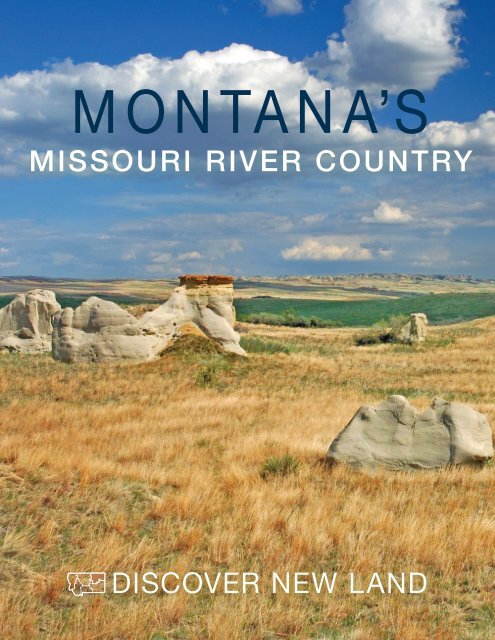
MISSOURI RIVER COUNTRY<br />
1<br />
TRAVEL PLANNER
MISSOURI RIVER COUNTRY<br />
East of the Haxby Road and north of Jordan | Rick and Susie Graetz<br />
What fun! This year they took me with them. No posh resorts or cruise ships this<br />
time. Just wide open spaces with fantastic fun for the whole family.<br />
We hiked. We swam. We explored. We boated. We went to parades and festivals.<br />
We hunted. We did all this and more amid some of the best scenery around. We slept in<br />
great little towns and ate some terrific food. I just can’t think of anything we didn’t do in<br />
Montana’s <strong>Missouri</strong> <strong>River</strong> <strong>Country</strong>.<br />
Best of all, we were welcomed by some fine folks who were truly glad we were there.<br />
Yes, even I was welcome (in most places)!<br />
If you are tired of being locked up in the kennel, and your family is stuck doing the<br />
“same old cruise ship” thing, tell them to consider Montana’s <strong>Missouri</strong> <strong>River</strong> <strong>Country</strong> for<br />
their next vacation. Assure them they will all have a great visit! Then hang your head out<br />
the window and explore some true beauty and have a dog gone good time!<br />
Andy the President’s<br />
Golden Retriever<br />
Contents<br />
This Is <strong>Missouri</strong> <strong>River</strong> <strong>Country</strong>......................4<br />
Our Friendly Towns......................................6<br />
Lewis and Clark.........................................12<br />
Notes for Traveling in NE MT......................14<br />
Big <strong>Country</strong> Under a Big Sky.....................16<br />
Landscapes...............................................17<br />
<strong>Missouri</strong> <strong>River</strong> to the Confluence...............20<br />
Valley of the Milk <strong>River</strong>...............................23<br />
Montana Map............................................26<br />
The Yellowstone in the MRC......................28<br />
Prairie Magnificence..................................31<br />
Great Northeast.........................................34<br />
Hunting.....................................................37<br />
Fishing.......................................................38<br />
Wildlife ......................................................39<br />
Bicycling....................................................42<br />
Events.......................................................44<br />
Accommodations......................................48<br />
MISSOURI RIVER COUNTRY<br />
2<br />
TRAVEL PLANNER
Heading towards the sunrise and leaving the abrupt wall<br />
of the Northern Rocky Mountains behind, one approaches the<br />
most magnificent prairie country in the nation… the northeast<br />
quadrant of the Big Sky - <strong>Missouri</strong> <strong>River</strong> <strong>Country</strong> - an uncommon<br />
piece of geography.<br />
This place of the Northern Great Plains harbors unique<br />
landforms. Grand scenes intermingle with smaller bits of<br />
geologic wonder. Space, much of it undisturbed, is its greatest<br />
commodity and an enormous sprawling canopy of sky delivers<br />
a feeling of no borders or confinement where a human can<br />
stretch and breathe.<br />
At first, the pervasive openness, the immensity and the<br />
distances may seem overpowering. Gradually though, you get<br />
comfortable with it all; then you notice the beauty and splendor.<br />
Not just the imposing structures, but also the abundance<br />
of simple grandeur and the soft fusion of earth and sky on<br />
seemingly endless horizons.<br />
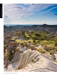
Island mountain ranges, buttes, river breaks, canyons,<br />
badlands and a largely untouched landscape are the hall-marks<br />
of this big territory. If Lewis and Clark went up against the<br />
current of the big <strong>Missouri</strong> today, as they did in 1805, the explorers<br />
would recognize much of what they viewed back then.<br />
<strong>Missouri</strong> <strong>River</strong> <strong>Country</strong> is where Montana’s earliest<br />
k<strong>now</strong>n history was played out. Millions of bison migrated<br />
through the territory and nomadic Plains Indians followed<br />
them. The shaggy beasts sustained these great Indian Nations<br />
by providing food, clothing and shelter.<br />
Much of early-day Montana deserves the description the<br />
Wild West, but the landscape of the Little Rocky Mountains<br />
and of the country rolling south into the <strong>Missouri</strong> Breaks in<br />
the western sectors of <strong>Missouri</strong> <strong>River</strong> <strong>Country</strong> was perhaps the<br />
epitome of the Old West etched on movie screens. It’s been<br />
scarcely 150 years since the characters of those times ... cattle<br />
barons, gold seekers, outlaws, cowboys, vigilantes, rustlers and<br />
horse thieves went about their way here.<br />
The centerpiece of Northeast Montana is undeniably the<br />
mighty <strong>Missouri</strong> <strong>River</strong>. As a route of western expansion, it had<br />
few equals and became Montana’s lifeline to the rest of the<br />
country. Here, this powerful river holds forth in an incredible<br />
landscape of rough river breaks. Sculpted and cut by water, a<br />
labyrinth of coulees, gullies and canyons between high ridges<br />
fan out to the north and south from the river’s banks.<br />
Though mountains are scarce in this country, a dominant<br />
range makes its presence k<strong>now</strong>n. Indians migrating through<br />
the territory north of the <strong>Missouri</strong> <strong>River</strong> called them “the<br />
island mountains.” From a distance, the Little Rockies, a<br />
50-square-mile mass of igneous and sedimentary rock, resemble<br />
an atoll rising from the prairie sea of Northeast Montana.<br />
THIS IS MISSOURI RIVER COUNTRY<br />
French trappers, working the lower segments of the<br />
<strong>Missouri</strong> and Yellowstone rivers well before Lewis and Clark<br />
came through, referred to the barren, dry land formations<br />
they encountered as “les mauvais terres” (badlands). How-ever,<br />
exquisite sandstone formations are often found intermingled<br />
with these badland environments. Miniature and giant<br />
toadstools, castles and cathedrals, fine lined domes, balancing<br />
rocks, sentinel-like spires and other beautiful nature-carved<br />
statues add color and personality to these rain-furrowed hills<br />
while gremlins and goblins stand watch atop high cliffs. Wind<br />
erosion helps fashions them, taking away one grain of sand at<br />
a time.<br />
These landscape descriptions are but a few of a territory<br />
fitted with awesome prairie scenery. And places like the sprawling<br />
Charles M. Russell and Medicine Lake national wildlife<br />
refuges not only encompass incredible beauty, but are also<br />
home to wildlife populations unparalleled on the high plains.<br />
There are fewer people in Northeast and North Central<br />
Montana than anywhere else in the state; space dwarfs this<br />
human presence whether it is on farms and ranches well apart<br />
from neighbors, or in towns. A look at some of the communities<br />
out here shows the colorful human side to this <strong>Missouri</strong><br />
<strong>River</strong> <strong>Country</strong>. These enclaves aren’t new, but rather have<br />
evolved from the solid “stock” of folks who struggled through<br />
the ruinous drought that halted the home-stead era, the tough<br />
winters and a roller coaster agricultural climate. Today, the<br />
citizens of these communities are the backbone of the Montana<br />
prairie country.<br />
Towns are the essence of this territory where the natural<br />
features capture attention. Social and commercial activities<br />
interact within them in a way that is all but disappearing across<br />
America. Cafes, hardware and grocery stores are where stockmen,<br />
farmers, implement dealers and bankers meet to discuss<br />
ag-economics, their families, and the weather. You’ll still find<br />
drug stores with soda fountains and chances are you can walk<br />
in the door of any business and shake the hand of the owner. A<br />
genuine welcoming atmosphere prevails.<br />
These descendants of sodbusters and cattle outfits that<br />
have been in the same family for generations provide the<br />
region with a sense of permanency and independence. A strong<br />
profile dictated by rural life and past experiences characterizes<br />
the folk who call the northeast Montana plains home.<br />
We, the residents of this quiet corner of Montana, invite<br />
you to commence your trip of discovery through our beautiful<br />
landscape and to experience our aura of history. Each of us will<br />
do all we can to make you comfortable. The gate is open so<br />
come join us. You will not be disappointed! MRC<br />
MISSOURI RIVER COUNTRY<br />
3<br />
TRAVEL PLANNER
MISSOURI RIVER COUNTRY<br />
4<br />
TRAVEL PLANNER
OUR FRIENDLY TOWNS<br />
fo o d l o d g i n g g a s c a m p i n g<br />
BAINVILLE<br />
Pioneer Pride Museum features rooms<br />
furnished as they were in the days of<br />
the pioneers. An old jail and a 1929<br />
fire truck add to the attraction. Open<br />
Memorial Day-Labor Day, Tues–Sun,<br />
1:30-4:30pm, free admission. • 406-<br />
769-2067<br />
BROCKTON<br />
Come help celebrate the Badlands with a<br />
powwow the 4th weekend in June.<br />
BROCKWAY<br />
In July, it’s always fun for families and<br />
folks at the Dairy Day Celebration and<br />
Rodeo.<br />
BRUSETT<br />
North of Jordan, accesses the Charles M.<br />
Russell National Wildlife Refuge.<br />
CIRCLE<br />
The McCone County and Circle Museum<br />
is a trip back to ranching and life<br />
in the 1880s. The wildlife taxidermy<br />
collection is outstanding. Open weekdays,<br />
May-Sept, 9am-5pm (other times<br />
by appointment), adults $2.00, children<br />
free • 485-2414<br />
CULBERTSON<br />
Culbertson Museum and State Visitor<br />
Information Center’s guided tours show<br />
early-day businesses, church, school<br />
and home. Open daily May thru Sept,<br />
8am-8pm, free admission - coffee and<br />
homemade cookies. • 406-787-6320<br />
DAGMAR<br />
Brush Lake State Park, four miles east<br />
of the Danish settlement of Dagmar,<br />
offers a spring fed, deep-water lake for<br />
swimming, boating, camping and other<br />
outdoor fun.<br />
DODSON<br />
Don’t miss the Phillips County Fair, the<br />
longest running fair in Montana, the<br />
first week in August.<br />
FAIRVIEW<br />
It’s the town divided by the Montana/<br />
North Dakota border.<br />
Visit the nearby rare, vertical-lift bridges<br />
- Fairview and S<strong>now</strong>den/Nohly. The<br />
Fairview Bridge, which is listed on the<br />
National Register of Historic Places for<br />
its past significance and unique engineering,<br />
and the Cartwright Train Tunnel<br />
have been developed into an enjoyable<br />
walking trail, which takes you across<br />
the Yellowstone <strong>River</strong> and through the<br />
one-lane tunnel. Ask locally how to get<br />
to the S<strong>now</strong>den/Nohly Bridge over the<br />
<strong>Missouri</strong> <strong>River</strong>.<br />
FLAXVILLE<br />
Here you can find a piece of Montana’s<br />
past to take back with you. Home to<br />
antiques and collectables for sale<br />
• 406-474-2277<br />
FORT PECK<br />
The Powerhouse Museum has a pictorial<br />
history of the dam construction, also<br />
models and exhibits. The more than 400<br />
dinosaur and fossil specimens found in<br />
the area include an enormous skull of a<br />
Triceratops. Open Memorial Day thru<br />
Labor Day, tours of the powerhouse begin<br />
at the Fort Peck Interpretive Center.<br />
Weekdays - 9am, 11am, 1pm and 3pm.<br />
Weekends and holidays - every hour -<br />
9am-4pm. 406-526-3493. Must have<br />
picture I.D.<br />
Fort Peck Summer Theatre is the region’s<br />
only professional summer stock theater.<br />
Laughter and music ring from the rafters<br />
of this exotic and historical building.<br />
Built during the depression the theater,<br />
with its seating for 1,200, was for<br />
decades the largest facility of its kind in<br />
the state.<br />
Top Left: Opheim | Rick and Susie Graetz<br />
Native American Dancer | Wolf Point Chamber of Commerce and Agriculture<br />
MISSOURI RIVER COUNTRY<br />
5<br />
TRAVEL PLANNER
Today this<br />
delightfully<br />
designed<br />
theater is on<br />
the National<br />
Historic Registry.<br />
Professional<br />
actors and<br />
technical crew<br />
join a seasoned<br />
director and<br />
volunteers to produce quality entertainment<br />
as enjoyable and creative as<br />
the historic theater itself. Open May<br />
thru August, performances are Fri–Sat<br />
evenings at 8pm and Sun. 4pm. Reservations<br />
are not needed and tickets may<br />
be purchased at the door. Casual dress. •<br />
406-228-9216<br />
Off of Hwy 17, the Leo B. Coleman<br />
Wildlife Exhibit is a loop-drive around<br />
230 acres that are home to elk, bison,<br />
antelope and mule deer.<br />
Lewis & Clark Overlook is ½ mile east<br />
of the dam powerhouse on Hwy 24.<br />
Interpretive signage, picnic area and restroom<br />
facilities are handicap accessible.<br />
Continue East on Hwy 24 and you will<br />
cross the dam’s spillway. Then to the left<br />
is the road (l.5 mi.) to the Milk <strong>River</strong><br />
Observation Point and Hiking Trail.<br />
This is a great chance to get out of the<br />
Town Square park in Plentywood | MontanaPictures.net<br />
car, stretch your legs and see the colored<br />
water of the Milk <strong>River</strong> mix with the<br />
<strong>Missouri</strong>.<br />
The Fort Peck Interpretive Center, an<br />
exciting exhibition hall and museum,<br />
features dinosaur exhibits including one<br />
of the most complete Tyrannosaurus rex<br />
skeleton, fossils of eastern Montana, construction<br />
of the dam and the wildlife of<br />
the C.M. Russell National Wildlife Refuge.<br />
Two enormous aquariums are home<br />
to a representation of the fish found in<br />
the area. Admission is free and hours are<br />
9am to 4pm daily.<br />
The new Fort Peck Fish Hatchery’s primary<br />
role is producing walleye to stock<br />
in Fort Peck Reservoir and other waters<br />
in Montana, it will also produce largemouth<br />
bass, northern pike, sauger, Chinook<br />
salmon and channel catfish and is<br />
equipped to hatch and rear endangered<br />
pallid sturgeon.<br />
The hatchery is open<br />
from 8am-5pm<br />
on weekdays for<br />
self-guided tours. A<br />
viewing window gives<br />
visitors a glimpse of<br />
the facility’s inner<br />
workings and interpretive<br />
displays<br />
explain various FWP<br />
programs in addition to the life cycle of<br />
walleye and fish of the region.<br />
FORT UNION<br />
Trading Post<br />
Explorers Lewis and Clark recognized<br />
the area for its potential wealth, strategically<br />
perched at the confluence of the<br />
Yellowstone and <strong>Missouri</strong> rivers. Naturalist<br />
John James Audubon visited Fort<br />
Union in 1843 and spent two months in<br />
the area documenting the “Quadrupeds<br />
of North America” and new species of<br />
birds.<br />
Built in 1829, the fort soon emerged as<br />
the upper-<strong>Missouri</strong> <strong>River</strong> commerce center,<br />
trading pelts and buffalo robes from<br />
the Assiniboine for retail and manufactured<br />
goods.<br />
Today, surrounded by an authentic mid-<br />
19th century setting, this National His<br />
Brush Lake | Tim Hutslar<br />
MISSOURI RIVER COUNTRY<br />
6<br />
TRAVEL PLANNER
Medicine Lake Parade | Tim Hutslar<br />
Fort Peck Reservation | Carolyn Sorensen<br />
toric site welcomes visitors to investigate<br />
life as it was almost 200 years ago. Open<br />
every day except Thanksgiving, Christmas<br />
and New Years, 9am-5:30pm, hours<br />
are extended in summer. Ranger guided<br />
tours in summer take guests through<br />
Bourgeois House—the post manager’s<br />
quarters, and the Indian Trading House,<br />
where trades and sales were made. • 701-<br />
572-9083<br />
FRAZER<br />
Colorful costumes, mesmerizing dances,<br />
rhythmic music and singing and traditional<br />
ceremonies are celebrated the 3rd<br />
weekend in June during the Red Bottom<br />
Pow Wow.<br />
FROID<br />
This small prairie town is an agricultural<br />
center offering full services and superb<br />
hunting.<br />
GLASGOW<br />
Sunnyside Golf & <strong>Country</strong> Club is<br />
Circle | Rick and Susie Graetz<br />
semi-private, but open to non-resident<br />
visitors. It has a reputation of having the<br />
best greens in northeast Montana. White<br />
yardage—3,152 yards, blue—3,233<br />
yards and ladies—2,875 yards. Open<br />
daily. • 406-228-9519<br />
Valley County Pioneer Museum has an<br />
extensive Lewis & Clark exhibit featuring<br />
the wildlife, plants they noted in<br />
their journals and largest Assiniboine<br />
collection on exhibit in the US. Displays<br />
include dinosaur bones, Indian artifacts,<br />
homesteaders, Fort Peck Dam history,<br />
the Buffalo Bill Cody bar and the history<br />
of local aviation. Open May 1 thru Labor<br />
Day, 8:30am-5:30pm, Fall & Winter<br />
1:00pm-4:00pm • 406-228-8692<br />
Children’s Museum of NE MT provides<br />
hands on activities for kids. Hours are<br />
Mon., Wed., Thurs., and Fri. from 10am<br />
to 5pm and Sat. from 10am to 3pm.<br />
www.nemtchildrensmuseum.com 514<br />
2nd Ave. S., 406-228-4FUN<br />
Good Kind Art Gallery is a contemporary<br />
art space whose focus is to “bridge<br />
the gap between local and outlying<br />
contemporary arts movements”. Open<br />
Tues.-Fri. 10am-6pm, Sat. 10am-3pm<br />
406-671-0659 www.glasgowgoodkindgallery.com<br />
HINSDALE<br />
This modest Hi-line enclave comes alive<br />
during the Milk <strong>River</strong> Days and Rodeo<br />
celebrated every 4th of July.<br />
JORDAN<br />
Garfield County Museum spotlights<br />
the exciting dinosaur discoveries in the<br />
nearby Hell Creek fossil beds. An actual<br />
Tyrannosaur’s head and a full-size replica<br />
of a Triceratops are on display. The 1912<br />
homesteading era is portrayed and includes<br />
a schoolhouse, jail and blacksmith<br />
shop. Open daily, June 1 to Labor Day,<br />
1-5pm, free admission. • 406-557-2577<br />
• twww.garfieldcounty.com<br />
LANDUSKY<br />
This once raucus, thriving gold camp sits<br />
hard up against the Little Rocky Mountains.<br />
Camping is available nearby.<br />
LAMBERT<br />
The Lambert Historical Society Museum<br />
traces the town’s earliest beginnings from<br />
1914 with historical tribute to native<br />
son, former Governor Nutter. Open<br />
May - Sept, Tues and Thurs, 11am-2pm,<br />
free admission. • 406-774-3439<br />
MISSOURI RIVER COUNTRY<br />
7<br />
TRAVEL PLANNER
Two girls in wagon | Tim Hutslar<br />
MALTA<br />
Phillips County Museum located on US<br />
Highway 2, includes displays of early<br />
Plains Indian artifacts, homesteading,<br />
ranching, farming and mining in the<br />
county, dinosaur and marine fossils<br />
found in the area and an exhibition telling<br />
the story of Kid Curry’s famous 1901<br />
train robbery just west of town. Visit our<br />
website at www.phillipscountymuseum.<br />
org or call • 406-654-1037 for hours,<br />
rates and more information. The Great<br />
Plains Dinosaur Museum and Field<br />
Station displays rare fossils: fish, invertebrates,<br />
plants, and a variety of dinosaur<br />
species such as Triceratops,<br />
Stegosaurus, sauropod, raptor, and<br />
Hadrosaurs “Roberta” and “Leonardo” -<br />
the mummy dinosaur listed as the “best<br />
preserved” dinosaur in the Guinness<br />
Book of World Records. Preparation lab<br />
and gift shop. Programs for all ages including<br />
summer field digs and area tours<br />
available. Season and hours of operation<br />
available at www.greatplainsdinosaurs.<br />
org, dinosaur@itstriangle.com, 406-654-<br />
5300. Located on Hwy 2 East next to<br />
the Phillips County Museum.<br />
Marion Hills Golf Course, a picturesque<br />
3,475-yard course, is considered the<br />
most challenging in the region • Open<br />
daily to the public • 406-654-5527<br />
The Bowdoin National Wildlife Refuge<br />
is just seven miles from town. • 406-<br />
654-2863<br />
MEDICINE LAKE<br />
This beautiful rural town is host to those<br />
who come to visit the thousands of<br />
migratory and nesting birds at the Medicine<br />
Lake National Wildlife Refuge. It<br />
offers full services to hunters and visitors<br />
alike. • 406-789-2305. For information<br />
about local events call • 406-789-2242<br />
NASHUA<br />
This gateway to water recreation at Fort<br />
Peck Lake features Bergies - an icecream<br />
parlor with homemade ice cream.<br />
PLENTYWOOD<br />
Plentywood Golf Course is public with a<br />
pro shop on site. The 5,196-yard course<br />
is hilly, breezy and open. Rentals are<br />
available and the course is open from<br />
7am - dark. • 406-765-2532<br />
Sheridan County Museum is dedicated<br />
to the preservation of Montana’s pioneer<br />
heritage. View the longest indoor<br />
mural in the state and wander amongst<br />
the hundreds of antique tractors and<br />
threshers. The surrender of the Great<br />
Sioux Chief Sitting Bull is remembered<br />
with a monument. Open Memorial Day<br />
to Labor Day, Daily from 10am to 5pm,<br />
free admission. • 406-765-2145<br />
Just outside of town, there’s swimming,<br />
fishing and picnicking under the openair<br />
cabanas at Bolster Dam.<br />
Still operating for your summer pleasure,<br />
one of the few drive-in movie theaters<br />
left in the state.<br />
MISSOURI RIVER COUNTRY<br />
8<br />
TRAVEL PLANNER<br />
Fort Peck Theater | Rick and Susie Graetz<br />
Almost every big game animal k<strong>now</strong>n<br />
to the state, plus 27 species of African<br />
animals can be admired up close here on<br />
the walls of local sporting goods stores.<br />
POPLAR<br />
Fort Peck Assiniboine and Sioux Culture<br />
Center and Museum features a permanent<br />
exhibit of its Native American<br />
heritage, arts and crafts. Open daily,<br />
8am-4:30pm, free admission. • 406-768-<br />
5155 Ext 328<br />
City Museum emphasizes fur trade from<br />
the 1840s through the 1860s and ranching<br />
and homesteading in the 1900s. It<br />
depicts the growth of a frontier town<br />
from an Indian camp. Open daily, June<br />
1-Sept 1, 11am-5pm, Mon–Fri, free<br />
admission. • 406-768-5223<br />
Poplar Indian Days are celebrated with a<br />
powwow the last weekend in August.<br />
SACO<br />
Chet Huntley Schoolhouse is preserved<br />
as the typical country school it was when<br />
the national newscaster, Mr. Huntley,<br />
attended.<br />
SAVAGE<br />
The Agate Stop, home of the Montana<br />
Agate Museum, presents God’s Paintings<br />
in Stone. See the glorious displays of<br />
Montana agates and other art depicting<br />
the stories of the Clark Travels through<br />
the Yellowstone Valley. Beverages served<br />
in a quaint setting. • 406-776-2373
SCOBEY<br />
The Scobey Golf Club course has been<br />
called “the best-kept secret” in northeast<br />
Montana. The 3,059-yard course<br />
with water hazards and two long, par-5<br />
holes is open from dawn to dusk. Golf<br />
carts, light lunches, alcoholic and soft<br />
drinks are available. • 406-406-487-<br />
5322<br />
In Pioneer Town and Museum, walk<br />
the boardwalks of a life-size old west<br />
Montana town. Stroll past St. Michael’s<br />
Ukrainian Greek Orthodox Church,<br />
take a right at the Dirty Shame Saloon<br />
and wander down main street visiting<br />
stores and peering through business<br />
windows. Scobey and other towns have<br />
donated more than 50 buildings from<br />
the Homestead Era that since have been<br />
restored, furnished and are <strong>now</strong> maintained<br />
by volunteers, local businesses<br />
and organizations. Open Memorial Day<br />
to Labor Day. Admission is charged. •<br />
406-487-5965<br />
Pioneer Town truly comes alive the<br />
last weekend in June with antique car<br />
and tractor displays, an art show and a<br />
parade. The Dirty Shame Show featuring<br />
the Dixieland Band and the dancing of<br />
the Dirty Shame Belles gets everyone in<br />
a festive mood for the three-day event.<br />
SIDNEY<br />
The Sidney <strong>Country</strong> Club is eastern<br />
Montana’s only 18-hole golf course east<br />
of Billings, and is a semi-private club<br />
open to out-of-town visitors. An enjoyable<br />
and varied level of play, this course<br />
has an on-site pro, a pro shop, bar and<br />
restaurant. Tee times required. • 406-<br />
433-1894<br />
REX Theater | Rick and Susir Graetz<br />
The MonDak Heritage Center, Museum<br />
and Art Gallery is one of the<br />
finest museums in eastern Montana.<br />
Stroll the boardwalk of an authentically<br />
reconstructed 1910 version of the<br />
town featuring a schoolhouse, bank,<br />
post office, train depot and an original<br />
homesteader’s shack. Two art galleries<br />
with regularly changing exhibits, an art<br />
library and a research library with local<br />
history, photos and genealogical records<br />
ensure an interesting visit for all. Open<br />
Feb-Dec, Tues-Fri, 10am-4pm and Sat<br />
1-4pm. www.richland.org<br />
• 406-433-3500<br />
The Lewis and Clark Information Center<br />
located in the Chamber of Commerce<br />
building. Includes an interactive computer<br />
program, artifacts, publications<br />
and brochures.<br />
The <strong>Missouri</strong>-Yellowstone Confluence<br />
Interpretive Center located three miles<br />
east of Fort Union at the actual confluence<br />
site, features Lewis & Clark, the<br />
local geography and genealogy and the<br />
history of Fort Buford. Open all year, admission<br />
charged. Call • 701-572-9034<br />
for hours. www.DiscoverND.com/hist<br />
WESTBY<br />
Camp along the Montana/North Dakota<br />
border surrounded by prairie pothole<br />
country and all the winged creatures it<br />
invites.<br />
WOLF POINT<br />
The Airport Golf Club is a private<br />
9-hole course accessible to the public.<br />
The seasonal, partially wooded links are<br />
playable from daylight to dark. Lunch<br />
served. • 406-653-2161<br />
Historical Society and Museum displays<br />
artifacts of the area’s early settlers and<br />
Indians, including period clothing,<br />
arrowheads and weapons. There is also<br />
an art gallery, and a video for the handicapped<br />
is available. Open Memorial Day<br />
thru Labor Day, Mon-Fri, 10am-5pm •<br />
406-653-1912<br />
Home of Montana’s oldest rodeo—the<br />
Wild Horse Stampede, and the Wadopana<br />
Pow Wow.<br />
Commercial airline and Amtrak services<br />
available.<br />
ZORTMAN<br />
Snuggled up against the Little Rockies,<br />
Zortman takes one back in time. Enjoy<br />
hiking the mountain trails among these<br />
Island Mountains and pan for gold in<br />
this historic mining town. • 406-654-<br />
1776<br />
At the Slippery Ann Ranger Station<br />
just down the road, an auto-tour route<br />
enables wild animal viewing, especially<br />
during the elk bugling season.<br />
Entering Westby from the west | Rick and Susie Graetz<br />
MISSOURI RIVER COUNTRY<br />
9<br />
TRAVEL PLANNER
MISSOURI RIVER COUNTRY<br />
10<br />
TRAVEL PLANNER
1<br />
2<br />
3<br />
4<br />
5<br />
6<br />
LEWIS & CLARK IN MISSOURI RIVER COUNTRY<br />
AREAS OF INTEREST<br />
MISSOURI/YELLOWSTONE<br />
CONFLUENCE - nearby Fort<br />
Union<br />
SOUTH OF CULBERTSON ON<br />
HWY 16 AT MISSOURI RIVER<br />
BRIDGE - Interpretive signage,<br />
picninc area, boat ramp.<br />
SOUTH OF WOLF POINT ON<br />
HWY 13 AT MISSOURI RIVER<br />
BRIDGE - Interpretive signage,<br />
picnic area, nature walk, boat<br />
ramp.<br />
GLASGOW - Vallet County Museum<br />
has an authentic Assiniboine<br />
elk hide tipiwhich is part of the<br />
Johsua Wetsit Collection and is<br />
one of the last three hide tipis in<br />
existence. A computer interactive<br />
kiosk features the never before<br />
told Assiniboine oral history in the<br />
native language by actual descendants<br />
of those who observed<br />
the Corps of Discovery<br />
MILK RIVER OBSERVATION<br />
POINT - View of the Milk <strong>River</strong><br />
from near the vantage point that<br />
Captain Lewis named the river.<br />
Four interpretive signs, 1/4 mile<br />
elevated hike, benches, parking<br />
area.<br />
LEWIS AND CLARK OVERLOOK<br />
- Interpretive signs, picnic area,<br />
vault toilets, benches.<br />
“The country we passed today...<br />
is one of the most beautiful plains we<br />
have yet seen, it rises gradually from<br />
the river bottom...then becoming level<br />
as a bowling green...as far as the eye<br />
can reach...” Meriwether Lewis, May 6,<br />
1805 near Frazer, Montana.<br />
On April 27, 1805 the Corps of<br />
Discovery first stepped foot into what<br />
would become Montana and <strong>Missouri</strong><br />
<strong>River</strong> <strong>Country</strong> near today’s S<strong>now</strong>den<br />
Bridge. That evening Captain Meriwether<br />
Lewis described the day’s events<br />
in his journal. The words he wrote<br />
represent the first written history of<br />
Montana.<br />
Lewis and Clark’s adventure-filled<br />
historic route through Montana originates<br />
and terminates in <strong>Missouri</strong> <strong>River</strong><br />
<strong>Country</strong>. In all, the Expedition spent<br />
more time in the state than anywhere<br />
else - close to six months. Thirty-seven<br />
of those days were in <strong>Missouri</strong> <strong>River</strong><br />
<strong>Country</strong>, covering nearly 330 river<br />
miles and exposing them to some of<br />
the most varied and beautiful prairie<br />
country in the entire journey.<br />
Changing little since 1805-06,<br />
the landscape they encountered is yet<br />
today open, quiet and void of people.<br />
Experience it by vehicle, canoe, raft,<br />
motorboat, horse or on foot, and you<br />
will come away with an appreciation for<br />
this unique geography, not only rom<br />
gaining a sense of history, but through<br />
the pictures you’ll take in your mind<br />
and camera of the simple grandeur of<br />
northeast Montana.<br />
To better comprehend this epic<br />
passage, first read the captains’ journals,<br />
either abridged versions such as Lewis<br />
and Clark’s Montana Trail published<br />
by Northern Rockies Publishing or the<br />
complete journals as published by the<br />
University of Nebraska. Then sit on the<br />
bank of the <strong>Missouri</strong> in <strong>Missouri</strong> <strong>River</strong><br />
country and imagine these explorers<br />
passing by over two centuries ago.<br />
In the field, the Montana Atlas<br />
in Gazeteer is a good companion, as it<br />
delineates public and private lands and<br />
shows the roads.<br />
Lewis and Clark campsite locations<br />
as shown in this map are only approximate<br />
and based on the captain’s notes.<br />
Both the Yellowstone and the <strong>Missouri</strong><br />
<strong>River</strong>s have a dynamic flow and channels,<br />
junctions and sites have been and<br />
continue to be altered with time, and at<br />
least 11of their campsites are <strong>now</strong> under<br />
the waters of Fort Peck Lake.<br />
MRC<br />
Oppoaite: <strong>Missouri</strong> <strong>River</strong> Breaks at S<strong>now</strong> Creek, | Rick and Susie Graetz<br />
MISSOURI RIVER COUNTRY<br />
11<br />
TRAVEL PLANNER
MISSOURI RIVER COUNTRY<br />
12<br />
TRAVEL PLANNER
NOTES FOR TRAVELING IN NORTHEAST MONTANA<br />
Traveling in northeast Montana will give you an opportunity to discover a piece of<br />
our nation that has changed little with time. Don’t rush through it, rather, savor the<br />
experience and let the peace and power of the landscape become a part of you.<br />
Your Vehicle.<br />
An ordinary road car or camper will suffice for the main<br />
highways and the well traveled gravel roads. However, there are<br />
many less maintained byways into the <strong>Missouri</strong> Breaks, Charles<br />
M. Russell Wildlife Refuge, Fort Peck Lake area and elsewhere<br />
where an all wheel drive rig with clearance is needed. It is best<br />
to make local inquiries as to the condition of a given road.<br />
Weather and Roads. The paved highways and gravel back<br />
roads are passable in all but the worst winter weather.<br />
Many of the out-of-the-way routes are dirt surfaced and<br />
most of the earth in these parts consists of bentonite. In dry<br />
weather they are fine to drive on, however, when s<strong>now</strong> is melting<br />
or it has been raining, these unimproved roadways turn<br />
to a “gooey gumbo,” making them impassable even with most<br />
4-wheel drive vehicles. Listen to weather reports or check with<br />
locals before venturing too far into the back country.<br />
Water. Food & Gas.<br />
Carry plenty of water with you to avoid dehydration. The<br />
humidity out here is low. There are enough communities along<br />
the highways with places to get gas, water and food. When<br />
venturing out into most of the lands beyond, services are<br />
non-existent so it’s a good idea to buy what you need in town.<br />
When to Travel. Spring dresses the prairie in its finest<br />
brilliance ... shades of green grasses and wheat fields stretch forever,<br />
a rainbow of wildflowers dots the landscape, while cloud<br />
patterns paint the horizon and magnificent sunsets follow<br />
MISSOURI RIVER COUNTRY<br />
13<br />
afternoon showers. For <strong>Missouri</strong> <strong>River</strong> <strong>Country</strong> at its best, this<br />
is the time to go ... early May until early July.<br />
Rain subsides during the summer, grasses cure to brown<br />
and yellow, maturing grain waves golden on the wind, billowy<br />
white clouds float through the clear blue sky and many rodeos<br />
and county fairs take place.<br />
By mid-September, autumn is in the air ... low lying brush<br />
turns red and the river bottom cottonwoods take on a flame<br />
orange hue. The sky can be cloudless for days. Wheat harvest is<br />
progressing and flocks of birds and geese are gathering on the<br />
lakes and ponds to prepare for their journey south.<br />
Try all three seasons, for each is special. This land is so big<br />
you need to take time to see it in all of its colors.<br />
Notes on Agriculture. Agriculture is Montana’s number<br />
one industry and in <strong>Missouri</strong> <strong>River</strong> <strong>Country</strong> it is the absolute<br />
mainstay of the economy. In simple terms, most of the landscape<br />
is a mixture of grass and grains ... ranching or dry land<br />
farming ... or is undisturbed.<br />
Badlands.<br />
Badlands are scattered throughout northeast Montana.<br />
This distinctive landscape is actually a small desert environment.<br />
Badlands come about when fire or some other disruption<br />
destroys the plant cover that would normally protect the<br />
soil from being eroded. Rain water hits the denuded surface<br />
and compacts it and new seeds can’t take hold. The run off<br />
starts forming gullies and soon strange looking formations<br />
TRAVEL PLANNER
North of Jordan on the Haxby Road | Rick and Susie Graetz<br />
consisting of bare earth appear. Badlands are usually<br />
permanent.<br />
Unusual and weird rock formations that look like toadstools<br />
or thin walls are scattered throughout the badlands.<br />
They are made of sandstone and were created by wind erosion<br />
once the vegetation disappeared.<br />
Red Rocks.<br />
In your travels throughout parts of <strong>Missouri</strong> <strong>River</strong><br />
<strong>Country</strong> you’ll note hills that have a distinct red and yellow<br />
look to them and add color to the prairie<br />
topography. These colorful rocks are<br />
commonly called scoria, but the proper<br />
name is clinker.<br />
Clinker or scoria is the baked red<br />
sandstone and shale that at one time was<br />
lying above a burning coal seam. The<br />
coal caught fire from lightning strikes or<br />
prairie wildfires. This overlying formation<br />
is made up of literally” cooked” or<br />
metamorphic rocks. Heated to a high<br />
temperature from the burning coal,<br />
oxygen combined with iron in the rock<br />
to form iron oxide producing the bands<br />
of red rust color evident in some of these<br />
hillsides. Clinker is a very hard rock, in a<br />
part of the world where most of the rocks<br />
East of Hinsdale | Rick and Susie Graetz<br />
are of a soft nature, and is used for surfacing some roads.<br />
Breaks.<br />
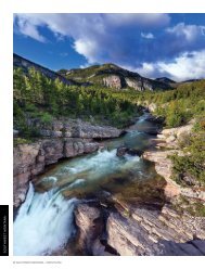
<strong>River</strong> breaks, such as the <strong>Missouri</strong> Breaks, are a major<br />
landform in <strong>Missouri</strong> <strong>River</strong> <strong>Country</strong>. Formed by the erosion<br />
of the soil and soft rocks through the action of water, small<br />
gulches and deep canyons are cut out of the higher landscape<br />
above main waterways, streams, rainwater and s<strong>now</strong> melt find<br />
their path to the river. The resulting terrain is rough, wild and<br />
spectacular.<br />
MRC<br />
MISSOURI RIVER COUNTRY<br />
14<br />
TRAVEL PLANNER
BIG COUNTRY UNDER A BIG SKY<br />
… The Landscapes of <strong>Missouri</strong> <strong>River</strong> <strong>Country</strong><br />
… A Place to Make new Discoveries!<br />
“This place of the Northern Great Plains harbors unique landforms. Grand scenes<br />
intermingle with smaller bits of geologic wonder. Space, much of it undisturbed, is its<br />
greatest commodity and an enormous sprawling canopy of sky delivers a feeling of no<br />
borders or confinement where a human can stretch and breathe.”<br />
“At first, the pervasive openness, the immensity and the distances may seem overpowering.<br />
Gradually though, you get comfortable with it all; then you notice the beauty and<br />
splendor. Not just the imposing structures, but also the abundance of simple grandeur<br />
and the soft fusion of earth and sky on seemingly endless horizons.”<br />
These words describe well the places of <strong>Missouri</strong> <strong>River</strong> <strong>Country</strong> that the following pages will showcase.<br />
They will take you on a journey through well-defined regions of a very uncommon corner of Montana.<br />
Let the journey begin!<br />
MISSOURI RIVER COUNTRY<br />
15<br />
TRAVEL PLANNER
LANDSCAPES<br />
Fort Peck Lake and the Charles M. Russell National Wildlife Refuge<br />
Fort Peck Lake looking south from the Pines | Rick and Susie Graetz,<br />
Opposite: East of the Haxby Road and northeast of Jordan | Rick and Susie Graetz<br />
It is an uncommon landscape...at once stark, beautiful,<br />
imposing, and inviting, this terrain holding Montana largest<br />
lake and the crown jewel of the nation’s wildlife refuge system,<br />
the Charles M. Russell National Wildlife Refuge. Time<br />
has left most of it with<br />
the same appearance as<br />
when the great Indian<br />
nations, among them the<br />
Assiniboine, Blackfeet,<br />
Nez Perce and Sioux<br />
hunted and did battle<br />
here. And while some of<br />
the wildlife species have<br />
disappeared, notably<br />
bison and grizzly bears,<br />
others, including elk and<br />
bighorn sheep, thrive.<br />
And if the Corps of<br />
Discovery were to revisit<br />
their original route, other<br />
than the sprawling lake,<br />
the landforms would still<br />
be familiar to them.<br />
Fort Peck community,<br />
long on colorful history,<br />
and 18 miles south<br />
of Glasgow, Montana via<br />
Trip Divide on the CMR National Wildlife Refuge<br />
Highway 24 is this regions and the lake’s eastern post.<br />
Campbell K. Peck and E.H. Durfee built old Fort Peck,<br />
a trading post and Indian agency, in 1867. With their new<br />
establishment the men had a near monopoly of the fur trade<br />
on this segment of the<br />
<strong>Missouri</strong>, trading with<br />
the Assiniboine and<br />
Sioux. Fort Union, near<br />
the confluence of the<br />
<strong>Missouri</strong> and Yellowstone<br />
rivers, and just across the<br />
border in today’s North<br />
Dakota, held sway as<br />
the most important fur<br />
trading post on the Upper<br />
<strong>Missouri</strong>; Fort Peck was a<br />
close second.<br />
The post was abandoned<br />
in the1879 and in<br />
a few years, the dynamic<br />
<strong>Missouri</strong> <strong>River</strong> swept<br />
away any remnants.<br />
In October of 1933,<br />
construction of Fort Peck<br />
Dam began. Completed<br />
in 1940, at the time it<br />
was the nation’s largest<br />
MISSOURI RIVER COUNTRY<br />
16<br />
TRAVEL PLANNER
The <strong>Missouri</strong> <strong>River</strong> Breaks and the Charles M. Russell National Wildlife Refuge | Rick and Susie Graetz<br />
public works project, providing at its peak in 1936<br />
10,456 jobs. The resulting Fort Peck Lake and its almost<br />
1600 miles of shoreline extends about 130 to the west behind<br />
this one of the largest earth - filled river impediments in the<br />
world measuring 21,026 feet in length. Its original purpose<br />
was not only to control floods, but also to create jobs in a<br />
depression-saddled economy.<br />
In the fall of 1933, with the commencement of the dam<br />
project, Fort Peck town site, planned and built by the Army<br />
Corps of Engineers to house its employees, began its orderly<br />
development. During the construction phase, the small settlements<br />
that sprung<br />
up around the<br />
town of Fort Peck<br />
were a boomtowns<br />
in every sense of<br />
the word. Thousands<br />
of workers<br />
from across the<br />
USA poured in to<br />
the region.<br />
Today Fort<br />
Peck Lake outdoor<br />
opportunities here<br />
are many. Six recreation<br />
areas within<br />
a few miles of<br />
Fort Peck provide<br />
access for water<br />
sports, fishing and<br />
hunting. Montana’s<br />
Governor’s<br />
Off of the Hell Creek Road and near Fort Peck Lake | Rick and Susie Graetz<br />
Cup Walleye Fishing Tournament, held the second weekend in<br />
July at Fort Peck, is a national event.<br />
The Beaver Creek Nature Trail, an easy three mile-long<br />
hiking path, starts at the campground downstream from the<br />
dam and leads through wildlife habitat along the <strong>Missouri</strong><br />
<strong>River</strong>. A self-guided wildlife-viewing auto route ... the Leo B.<br />
Coleman Wildlife Exhibit takes off from near the Fort Peck<br />
Summer Theater.<br />
Built in 1934 as a movie house for the new town, Fort<br />
Peck Theater offers a fine summer theater company. And Fort<br />
Peck lays claim to The Fort Peck Interpretive Center and<br />
Museum. The Center<br />
is one of Montana’s<br />
new treasures. It<br />
showcases great discoveries<br />
and aspects<br />
of this region. This<br />
18,000 square foot<br />
gem’s focus is on<br />
paleontology, wildlife<br />
and the construction<br />
of Fort Peck Dam.<br />
Its overall theme is<br />
northeastern Montana.<br />
As if this new<br />
center wasn’t enough,<br />
the nearby Powerhouse<br />
Museum displays<br />
a collection of<br />
Indian artifacts and<br />
fossils uncovered<br />
MISSOURI RIVER COUNTRY<br />
17<br />
TRAVEL PLANNER
during the construction of the dam.<br />
The 1.1-million acre Charles M. Russell<br />
National Wildlife Refuge straddles part of<br />
the free flowing <strong>Missouri</strong> <strong>River</strong> and encircles<br />
250,000-acre Fort Peck Lake.<br />
Legendary wildlife habitat, and one the<br />
finest collections of prairie topography in the<br />
west, best describes the CMR as it is commonly<br />
referred to. Started in 1936 as the Fort<br />
Peck Game Range for sharp-tailed grouse and<br />
antelope, the refuge occupies a large swath of<br />
Montana’s northeast quadrant and is in the<br />
center of some of the least inhabited country<br />
in the United States.<br />
From the western boundary ten miles<br />
upstream of the Fred Robinson Bridge near<br />
Grand Island, moving in a straight line, a<br />
plane or boat will cover 145 miles by the time<br />
it reaches the spillway of Fort Peck Dam and<br />
the eastern perimeter of the Refuge.<br />
The mix of land forms of the CMR is<br />
impressive. Table-top uplands give way to<br />
rugged coulees, wide and precipitous canyons<br />
(some 1,000 feet deep) and spectacular badlands.<br />
This much dissected expanse of ground<br />
has been carved by flows of water, such as<br />
Seven Blackfeet Creek, Devils Creek, S<strong>now</strong><br />
Creek, Hell Creek, the Musselshell <strong>River</strong>.<br />
Hence the term river breaks.<br />
Elevations and relief are low by Montana<br />
standards, but when looking up at some of<br />
the high points from the bottom of a gulch,<br />
the slopes appear as tough to climb as any<br />
mountain. The lowest elevation on the Refuge,<br />
when Fort Peck Lake is at full pool, is<br />
2,246 feet. One of the loftiest spots is 3,241<br />
feet, in the area above Seven Blackfeet Creek.<br />
The CMR is easily reached via numerous<br />
access roads leading from Glasgow, Fort Peck<br />
and Malta on the north and Jordan to the<br />
south of the lake.<br />
Combined with all the amenities offered<br />
by the Fort Peck area and the lake, this bit of<br />
<strong>Missouri</strong> <strong>River</strong> <strong>Country</strong> geography is one of<br />
the great treasures of the west! MRC<br />
Along the North Fork of Rock Creek Road,<br />
CMR National Wildlife Refuge | Rick and<br />
Susie Graetz<br />
MISSOURI RIVER COUNTRY<br />
18<br />
TRAVEL PLANNER
FROM FORT PECK TO THE YELLOWSTONE…<br />
THE MISSOURI’S WILD STRETCH<br />
Below Culbertson, on the <strong>Missouri</strong>, <strong>Missouri</strong> <strong>River</strong> <strong>Country</strong> | Rick and Susie Graetz<br />
Much of the <strong>Missouri</strong> <strong>River</strong> below Fort Benton, travels<br />
through country void of people and a region that enjoys<br />
federally protected status in the form of the Upper <strong>Missouri</strong><br />
<strong>River</strong> Breaks National Monument and the Charles M. Russell<br />
National Wildlife Refuge. Entering the domain of <strong>Missouri</strong><br />
<strong>River</strong> <strong>Country</strong> at Kipp Landing and the Hwy 191 crossing, it<br />
will pass through some of the most pristine lands of its journey<br />
covering 140 miles before reaching a town.<br />
Civilization is reached at the former Indian agency and<br />
trading post, Fort Peck on the far eastern edge of the Fort Peck<br />
Lake. The townsite is contiguous to the enormous dam that<br />
holds back the river, creating a huge body of water, that at full<br />
pool takes in about 145 square miles.<br />
After resting in Fort Peck Lake, the <strong>Missouri</strong> exits through<br />
the dam’s spillway and runs clear much as it did at its birthplace.<br />
In its natural state before the dams, the river was k<strong>now</strong>n<br />
for its excessive amounts of silt and mud. Estimates were that<br />
in every one million gallons of water, 120 tons of silt were suspended.<br />
Steamboats plying the river had to continually clean<br />
buckets of mud from their boilers.<br />
Within 10 miles of leaving Fort Peck and after regenerating<br />
a channel, the <strong>Missouri</strong> meets the Milk <strong>River</strong>. The extremely<br />
silt-laden waters of the Milk are pushed aside by the stronger<br />
flow of the <strong>Missouri</strong> as it fights to keep the murky color at bay.<br />
The intense contrast of the two flows creates a light colored<br />
banner along the north bank until finally, the Milk gives up<br />
and succumbs to the mightier <strong>Missouri</strong>.<br />
No longer held back by a barrier, the river changes as it<br />
rolls eastward from Fort Peck. Channel meanders increase and<br />
sand bars and islands are plentiful. And while the <strong>Missouri</strong> is<br />
still dynamic through its final 185 Montana miles, it doesn’t<br />
have the strength it did before Fort Peck Dam was completed.<br />
Spring runoff once ran freely and moved, sometimes dramatically,<br />
the waterway’s course and confluences with streams<br />
entering along the way.<br />
A true river again, it once more travels through a quiet<br />
terrain briefly touching a few small towns. Much of the geography<br />
this former “moving highway” and “lifeline to Montana”<br />
passes through is inaccessible by roads and is as wild as when<br />
the Corps of Discovery moved west against its current.<br />
There are several accounts of how Wolf Point, the next<br />
settlement on our trip, took its name. The most accepted<br />
version was that during a miserable 1860’s winter, “wolfers”<br />
killed several hundred gray wolves that froze before they could<br />
be skinned for their pelts. The hunters stacked the carcasses in<br />
high piles at their camp along the <strong>Missouri</strong> and waited for the<br />
spring thaw. Indians took over the landing and camp before<br />
the skins could be removed; the putrid piles remained. They<br />
became a visible and scented landmark, especially to the steamboats<br />
coming up river that spring.<br />
Documentation of Wolf Point’s exact beginnings is hard to<br />
come by. An 1834 map noted an Indian fort at the location. As<br />
a settlement, it was probably first established as a trading post<br />
for the fur trade. The place was a genuine frontier outpost and<br />
featured a dugout hotel along the river.<br />
In 1914, Wolf Point benefited from a growth spurt<br />
brought on by the arrival of farmers when Congress opened up<br />
the Fort Peck Reservation to homesteading by non-Indians.<br />
Poplar, the next town heading east, is headquarters for<br />
the Assiniboine and Sioux tribes and was named for the<br />
widespread stands of poplar trees on the riverbanks. Here, the<br />
Poplar <strong>River</strong> comes in from the north and the Redwater <strong>River</strong><br />
MISSOURI RIVER COUNTRY<br />
19<br />
TRAVEL PLANNER
adds a small amount of moisture on the south. The southern<br />
boundary of the Fort Peck Indian Reservation is defined by<br />
about 130 miles of the <strong>Missouri</strong>, extending from the mouth of<br />
the Milk to the Big Muddy <strong>River</strong>.<br />
The Corps of Discovery overnighted at present-day<br />
Poplar on May 3, 1805, and the captains<br />
named the Poplar <strong>River</strong> “Porcupine <strong>River</strong>,” because<br />
of the multitude of needled creatures inhabiting<br />
the place. Lewis penned that night, “the country<br />
in this neighborhood of this river, and as far as the<br />
eye can reach is level, fertile, open and beatifull<br />
beyond description. “<br />
They also christened the present Redwater<br />
<strong>River</strong>, “2000 mile creek,” estimating it was 2,000<br />
miles from St. Louis. Many of the places Lewis and<br />
Clark designated lost the original names owing to<br />
the delay in the publishing of their journals. Others<br />
who followed, not k<strong>now</strong>ing the sites already<br />
had a label, gave them different monikers.<br />
Thirty-three road miles from Poplar, The town of Culbertson,<br />
named for Alexander Culbertson, an early-day fur trapper<br />
from the American Fur, Company, got its start about 1888 and<br />
is considered to be one of the oldest towns in Montana east<br />
of the mountains. Just above the town the Big Muddy slowly<br />
works its way south from Canada to join the <strong>Missouri</strong>.<br />
A couple of miles southeast of Culbertson, the Hwy 16<br />
bridge crosses the <strong>Missouri</strong>. The sweeping river view from<br />
here is a favorite of photographers. Beyond the bridge, with<br />
34 miles left before the <strong>Missouri</strong> prepares to leave Montana<br />
and take on the Yellowstone, it rolls through a beautiful mix of<br />
bluffs, canyons and badlands. Continually impressed with the<br />
pleasant appearance of the landscape, William Clark declared<br />
“the Countrey on both Sides have a butifull appearance.”<br />
South of Bainville | Rick and Susie Graetz<br />
A bit north of the <strong>Missouri</strong>, Bainville, east of Culbertson<br />
on US Highway 2, is a place of note. This is the eastern-most<br />
Montana town on the “Hi-Line,” the road that stretches across<br />
South of Bainville | Rick and Susie Graetz<br />
the entire northern tier of Montana. It’s 641 miles from Bainville<br />
to Troy the western-most Montana community on the<br />
route - the road’s entire length in Montana is 667 miles.<br />
A few miles before leaving Montana, the <strong>Missouri</strong> passes<br />
S<strong>now</strong>den Bridge and the site of the former village of Nohly,<br />
where Lewis and Clark and their crew spent their first night<br />
in what would become Montana on April 27, 1805. As Lewis<br />
began writing in his journals that night, the words he put on<br />
paper represent the first written history of Montana.<br />
Once this historic spot is passed, the <strong>Missouri</strong> appropriates<br />
the Yellowstone <strong>River</strong> just beyond the Montana/North Dakota<br />
border. It still has a long way to go before catching the Mississippi,<br />
but it has left the finest landscapes of its journey behind<br />
in Montana. MRC<br />
MISSOURI RIVER COUNTRY<br />
20<br />
TRAVEL PLANNER
MISSOURI RIVER COUNTRY<br />
21<br />
TRAVEL PLANNER
THE VALLEY OF THE MILK RIVER<br />
Top: The confluence of the Milk and <strong>Missouri</strong> rivers from the Milk <strong>River</strong> Hills | Rick and Susie Graetz<br />
Opposite: Gilbert Creek region-CMR National Wildlife Refuge and west of the Big Dry Arm | Rick and Susie Graetz<br />
Tumbling off the Hudson Bay Divide in Glacier National<br />
Park to the west, the Milk <strong>River</strong> gains international status as it<br />
meanders into Canada 47 miles after its birth. After spending<br />
167 miles north of the border it regains US citizenship reentering<br />
Montana northwest of Havre. By the time it gives up<br />
its water to the <strong>Missouri</strong> <strong>River</strong> southeast of Glasgow, Montana<br />
the Milk will have covered 538 miles.<br />
This river serves well the geography it claims. Though<br />
sluggish, brown-colored and lacking beauty in itself, this liquid<br />
gold, through numerous diversion dams provides, much needed<br />
irrigation on the northern Montana prairie. And while it<br />
doesn’t have the splendor of some its peers, the terrain it visits<br />
is quite beautiful.<br />
Well after passing Havre and other northern Montana<br />
towns this wandering river is greeted by Malta, Montana.<br />
Between 1870 and 1900, this area was the setting for the true<br />
“Old West” and Malta might well be considered its capital.<br />
Trappers, cattlemen, cowboys, and all manners of outlaws wandered<br />
through here. Cattle drives up from Texas brought herds<br />
to winter on the region’s rich grasslands between the <strong>Missouri</strong><br />
and Canada. It was once the focal point of a vast beef empire<br />
and was founded to serve the area ranches. Big cow outfits held<br />
sway; names like Phillips, Coburn, Matador and Phelps are all<br />
etched in Montana’s history.<br />
Indians called the future town site “The Big Bend” as the<br />
Milk <strong>River</strong> turns in a half-circle near here. The first “citizen”<br />
was Robert M. Trafton out of Minnesota, who came to collect<br />
the bleached bones of slaughtered bison. In 1885, Trafton established<br />
a trading post a few miles to the west of what would<br />
eventually become the seat of Phillips County.<br />
The westward building Great Northern Railroad reached<br />
Siding 54 on August 13, 1887, and Trafton moved his store<br />
to the new town site in anticipation of increased business.<br />
Cowboys and other solitary souls inhabiting these high plains<br />
of north-central Montana needed a Saturday night destination;<br />
Malta became that place. And it was as wild as any western<br />
movie could depict!<br />
The newly minted community needed a proper name.<br />
Railroad agents gathering in Minneapolis, blindfolded an<br />
employee and had him point his finger to a spot on the globe.<br />
Thus Siding 54 was named Malta after an island in the Mediterranean<br />
Sea.<br />
Modern day Malta is a far cry from its raucous beginnings<br />
and <strong>now</strong> serves as a quiet agricultural center and a great base<br />
camp to explore some of the most unique prairie environment<br />
in Montana. To the south is the immense Charles M. Russell<br />
National Wildlife Refuge, the spectacular <strong>Missouri</strong> <strong>River</strong><br />
Breaks, Fort Peck Lake, the Little Rocky Mountains with their<br />
colorful mining history and the Fort Belknap Indian Reservation<br />
home to the Assiniboine and Gros Ventre nations.<br />
Seven miles east of town, Bowdoin National Wildlife Refuge<br />
is a premiere haven for waterfowl. It lies in the central<br />
MISSOURI RIVER COUNTRY<br />
22<br />
TRAVEL PLANNER
Bowdoin National Wildlife Refuge near Malta | Rick and Susie Graetz<br />
flyway of one of the great winged creature migration routes<br />
of North America.<br />
Continuing east Saco is the next Milk <strong>River</strong> Valley port<br />
of call. The name was derived in the<br />
same fashion as Malta’s. This time the<br />
finger landed on Saco, Maine. On the<br />
way, you’ll pass by Hewitt Lake National<br />
Wildlife Refuge and an access road<br />
to Nelson Reservoir, one of northeast<br />
Montana’s popular water recreation and<br />
fishing areas. This back road through the<br />
valley lets you approach the Milk <strong>River</strong><br />
in several places. Human sightings will<br />
be few, but you’ll probably encounter<br />
deer and antelope.<br />
Saco features a museum located in<br />
a renovated one-room county schoolhouse,<br />
the Huntley School, named after<br />
student Chet Huntley who went on to<br />
become a famous TV newscaster.<br />
Hinsdale, named for Reverend<br />
Hinsdale, is 14 miles east of Saco and on the Milk <strong>River</strong>. North<br />
of town, you’ll find some of the most spectacular and seldom<br />
visited badlands in Montana. Rock Creek Road, about two<br />
miles east of Hinsdale, heads north to Canada and leads into<br />
this region. About 18 miles up the road, you’ll be skirting the<br />
western edge of a true prairie wilderness ... the Bitter Creek<br />
region. Check with the BLM Office in Glasgow for a map and<br />
a description of the Bitter Creek Wildlife Viewing Area. It’s a<br />
loop trip through these badlands. The BLM recommends the<br />
use of a 4-wheel drive vehicle, and that you take a full eight<br />
South of Malta | Rick and Susie Graetz<br />
hours to do the trip.<br />
The terrain you’ll be driving through along Rock Creek<br />
is cowboy country. The ranches are big here and distances<br />
between human presences are great. If you look carefully along<br />
the ridges and hills above the creek, you’ll note faint remains<br />
of trails used by early-day Native Americans, including Sitting<br />
Bull.<br />
Toward the sunrise from Hinsdale, the Milk <strong>River</strong> switches<br />
to the south side of US Hwy 2 and its valley seems to open<br />
up even more than further west where hills and the distant<br />
Little Rockies are in site. Looks are deceiving though as just a<br />
bit south and north of this roadway the land is rugged, holding<br />
magnificent prairie terrain and sprawling ranch country.<br />
MISSOURI RIVER COUNTRY<br />
23<br />
TRAVEL PLANNER
Shortly the river reaches the thriving valley town of<br />
Glasgow. Glasgow’s location gives it access to all the wonders<br />
of huge Fort Lake to the south, and the prairie wild lands of<br />
Bitter Creek on the north. As the largest community in this<br />
part of northeast Montana, it offers plenty of amenities. Valley<br />
County Pioneer Museum has/offers exhibits and artifacts of all<br />
aspects of life on the northeast Montana prairie. Its collection<br />
ranges from Native Americans to the Homestead Era and is an<br />
outstanding and worthwhile place to study the vibrant past of<br />
the land the Milk <strong>River</strong> drains.<br />
Also in Glasgow, make sure you visit the South Valley<br />
Wildlife Viewing Area for an opportunity to see antelope, deer<br />
and other animals. The road route is about 65 miles long and<br />
can take three hours or more depending on how much time<br />
you have and what you want to see. Inquire at the Chamber<br />
of Commerce and Agriculture or the Glasgow Office of the<br />
Bureau of Land Management for maps, road conditions and<br />
information. Also check with the BLM on Bitter Creek directions.<br />
This is a great prairie eco system.<br />
Leaving Glasgow the Milk stays close to the highway,<br />
meandering, sometimes wildly, but for the most part keeping<br />
and easterly bearing. At Nashua, formerly a railroad depot, and<br />
14 miles from Glasgow this fabled river makes a sharp south-<br />
erly bend and then leads southwest covering its last leg before<br />
giving way to the <strong>Missouri</strong>. But where it meets the big river it<br />
makes its self k<strong>now</strong>. Here the <strong>Missouri</strong> is clear and cold, as its<br />
water has just come from the depths of Fort Peck Lake through<br />
the dam gates. The Milk though is muddy and warm and it<br />
makes a statement by streaming a stream of brown water well<br />
into the <strong>Missouri</strong> heading east.<br />
On May 8, 1805, the first “tourists” to this region, the<br />
Lewis and Clark Expedition, camped at the confluence of the<br />
Milk and <strong>Missouri</strong> rivers. Lewis explored the Milk for about<br />
three miles and said, “... the water of this river possesses a<br />
peculiar whiteness, being about the colour of a cup of tea with<br />
the admixture of a tablespoon full of milk. From the colour of<br />
its’ water, we called it Milk river.”<br />
Lewis also noted the Milk <strong>River</strong> Hills that rise almost 700<br />
feet above the floodplain of the Milk and <strong>Missouri</strong>. These can<br />
be ascended on their south side and reached via MT Hwy 24<br />
across Fort Peck Dam via a .05 mile-long hiking trail. From<br />
these points one can view much of the terrain Lewis and Clark<br />
described, both along the <strong>Missouri</strong> on the north side of the<br />
hills and southwest out over Fort Peck Lake. Clark most likely<br />
MRC<br />
mapped the area from this interpretive site.<br />
Bitter Creek, north of Glasgow | Rick and Susie Graetz<br />
MISSOURI RIVER COUNTRY<br />
24<br />
TRAVEL PLANNER
MISSOURI RIVER COUNTRY<br />
25<br />
TRAVEL PLANNER
THE YELLOWSTONE IN MISSOURI RIVER COUNTRY<br />
ROLLING ALONG FOR ABOUT 335 MILES in Montana’s <strong>Missouri</strong> <strong>River</strong><br />
<strong>Country</strong>, The <strong>Missouri</strong> takes top billing in northeast Montana. But the<br />
Yellowstone <strong>River</strong> isn’t just a bit player. While it only logs 50 miles in<br />
the territory, it takes in some exquisite landscapes and carries much<br />
Montana history with it.<br />
MISSOURI RIVER COUNTRY<br />
26<br />
TRAVEL PLANNER
Top: The Yellowstone <strong>River</strong> near Sidney | Rick and Susie Graetz<br />
Opposite: The Yellowstone <strong>River</strong> south of Sidney | Rick and Susie Graetz<br />
Gathering some of the finest mountain and prairie<br />
topography on the planet, Montana’s Yellowstone drains a<br />
70,000-square-mile piece of the west in grand fashion. Once<br />
serving as “a moving highway” into the wilderness, this unique<br />
river mirrored the passage of millions of bison, the travels of<br />
the Corps of Discovery, creation of the nation’s first national<br />
park and the foundations of a state.<br />
Long stretches haven’t changed since the Yellowstone’s<br />
not-so-long-ago yesterdays, much of the water continues to<br />
surge through clean space. Human presence has grown along<br />
the river, but for the most part it is unobtrusive. One could<br />
say this fabled waterway still represents the real Montana. The<br />
670-milelong waterway remains the nation’s longest undammed<br />
river.<br />
Savage and Crane, Montana, create small human outposts<br />
along a 15-mile stretch of the Yellowstone. Above Savage, in<br />
1909 a diversion dam was built for the Lower Yellowstone<br />
Irrigation Project. When the work was completed, there were<br />
nearly 400 miles of canals and ditches carrying Yellowstone<br />
<strong>River</strong> water to croplands, including widespread sugar beet<br />
fields. Historical notes show Savage, which benefited from<br />
the irrigation project, was named for H.M. Savage, a railroad<br />
official. The town of Crane, close to Sidney was titled after the<br />
owners of the Crane Ranch.<br />
From Savage to Sidney, nearing the end of its run, the<br />
river provides a popular floating stretch amid the Elk Island<br />
and the Seven Sisters Wildlife Management areas and the state<br />
owned Crittenden Island. Elk Island, actually three islands in<br />
high water and one in low flow, is near Savage, while Crane<br />
provides access to the seven small islands named Seven Sisters<br />
that legendary Yellowstone steamboat Captain Grant Marsh<br />
entitled in honor of his siblings.<br />
Floating from Elk Island to the Seven Sisters is a great way<br />
to see this special length of the Yellowstone, home to whitetail<br />
and mule deer, upland game birds, ducks and geese and other<br />
wild critters. It takes from five to seven hours to cover this<br />
12-mile stretch of water. Experienced “river rats” recommend<br />
paddling hard once you put in at Elk Island in order to get<br />
into the more scenic right-hand, side channel. And since the<br />
river moves slowly here, sightings of eagles, blue heron and all<br />
manners of birdlife are a strong possibility.<br />
William Clark wrote, on August 2, 1806, about this<br />
segment; “river wide and very much divided by islands and<br />
Sand and Mud bars ... Saw emence numbers of Elk Buffalow<br />
and wolves to day ... passed the enterance of Several brooks on<br />
each Side.” Clark was most likely describing Elk Island and the<br />
Seven Sisters.<br />
The river from Savage downstream with its wide bottoms<br />
crowded with islands and sandbars and cottonwoods growing<br />
in profusion, still looks very much as Clark depicted it. From<br />
Intake forward, the terrain on the river’s east side becomes<br />
rugged. Badlands and river breaks intermix and ascend well<br />
above the floodplain. Juniper, small ponderosa pine and green<br />
ash give a warm color to a harsh soil.<br />
Agates are another lower Yellowstone <strong>River</strong> attraction.<br />
Millions of years ago, volcanoes ruled Montana east of the<br />
MISSOURI RIVER COUNTRY<br />
27<br />
TRAVEL PLANNER
mountains. Powerful eruptions<br />
of molten lava and ash covered<br />
and destroyed hundreds of miles of<br />
forests. After centuries of activity,<br />
the climate cooled and rain washed<br />
silica and minerals from the surface<br />
of the land down into the labyrinths<br />
of hardened lava beds, filling<br />
the nooks and crannies with what<br />
several eons later would become<br />
Montana agates.<br />
In those unstable geologic<br />
times, mountains were being born<br />
and layers of buried lava broken<br />
up. Driving rains eroded the debris, washing it into the lower<br />
country. The Yellowstone <strong>River</strong> is the recipient of a magnitude<br />
of the alluvial gravel; and mixed among the rocks and stones<br />
are beautiful agate treasures waiting to be found.<br />
Sidney is about a mile west of the Yellowstone and about<br />
14 river miles short of its marriage to the <strong>Missouri</strong>. Named<br />
in 1888 for Sidney Walters, the young son of a local pioneer<br />
family, locals like to call it the Sunrise City, as this is where<br />
the sun first greets Montana. A pleasant community dotted<br />
with expansive tree-lined city parks, it is the largest town in<br />
northeast Montana. Sugar beets, wheat and ranching provide<br />
the dollars, and the exhibits at the highly acclaimed Mondak<br />
Heritage Center provide reminders of the rich, historical past.<br />
Between Sidney and Fairview, the valley of the Yellowstone<br />
spreads out in a display of agricultural artwork. At times<br />
looking like a billowing patchwork quilt, green fields of sugar<br />
beets are interspersed among squares of yellow wheat. Hay<br />
bales in various shades of gold scattered across the countryside<br />
give the scene definition.<br />
A few river miles north of Sidney, the Yellowstone crosses<br />
the North Dakota line, then abruptly changes her mind and<br />
rushes back into Montana. Finally, about two miles west of<br />
the border, the Yellowstone bids Montana adieu, turns toward<br />
North Dakota and stays on track for the <strong>Missouri</strong>.<br />
Some of Montana’s earliest recorded history was played<br />
Prickly Pear Cactus | Rick and Susie Graetz<br />
out here on the eastern fringes of<br />
our state where the Yellowstone<br />
ends its run. On April 27, 1805,<br />
the Corps of Discovery, after having<br />
spent a few days at the joining of<br />
the two rivers, first entered what<br />
would become Montana Territory.<br />
Fort Union stands out in this<br />
“Confluence <strong>Country</strong>,” from about<br />
1828 until 1867, it held supremacy<br />
over the fur trade business of the<br />
Upper <strong>Missouri</strong>.<br />
The original Fort Union, built<br />
in 1828 by John Jacob Astor and<br />
his American Fur Company, was located about six miles up the<br />
<strong>Missouri</strong> from the Yellowstone. A handsome, some would say<br />
royal place, it attracted famous men of the day. When the Fur<br />
Trade Era ended in 1867, the fort fell into disrepair. Much of<br />
the material was moved to aid in the expansion of Fort Buford,<br />
a military post closer to the Yellowstone’s confluence. Steamboats<br />
churning up the <strong>Missouri</strong> used what wood was left to<br />
feed their hungry boilers.<br />
Today, the Fort Union Trading Post National Historic Site<br />
has been reconstructed into an exact replica as it was in 1851,<br />
and with the natural reconfiguration of the rivers, it is about<br />
three air miles up from the joining of the waters. For anyone<br />
interested in the fabled <strong>Missouri</strong> and Yellowstone rivers, this<br />
historic site should be on your trail.<br />
The geographic history of the Yellowstone-<strong>Missouri</strong> Confluence<br />
is also worthy of note. The original site of the uniting<br />
of the rivers the Corps of Discovery witnessed is about two<br />
miles to the southwest of the current junction. A huge 1930’s<br />
flood forcibly moved it.<br />
Three miles from the eastern edge of Montana and Fort<br />
Union, the big, wide silt-laden Yellowstone gives up her independence<br />
to the <strong>Missouri</strong>, together forming one very formidable<br />
river. Under the flag of the <strong>Missouri</strong>, it lunges toward a<br />
rendezvous with the Mississippi <strong>River</strong>.<br />
MRC<br />
Below: Fort Union near Fairview, Rick and Susie Graetz Opposite: The Hell Creek area | Rick and Susie Graetz<br />
MISSOURI RIVER COUNTRY<br />
28<br />
TRAVEL PLANNER
PRAIRIE MAGNIFICENCE –<br />
JORDAN AND CIRCLE COUNTRY<br />
LATE 1800S PHOTOGRAPHER L. A. HUFFMAN<br />
called it “The Big Open,” National Geographic<br />
termed it “Jordan <strong>Country</strong>” and others dubbed the<br />
sparsely populated landscape south of Fort Peck<br />
Lake “The Big Dry.” The heart of this scenic territory<br />
is the small town of Jordan.<br />
MISSOURI RIVER COUNTRY<br />
29<br />
TRAVEL PLANNER
Prairie lands, north of Sand Springs | Rick and Susie Graetz<br />
Rising from the banks of Big Dry Creek and straddling<br />
Montana Hwy 200, Jordan was founded in about 1896 by<br />
Arthur Jordan. He asked that the town take the name of a<br />
friend from Miles City who was also named Jordan. The first<br />
residence was Arthur’s tent. Later, he established a post office<br />
and store for this fledgling cow town.<br />
The town and surrounding expanse of rangeland are still<br />
very much cowboy country, and the place retains an old west<br />
flavor. False front buildings on Main Street haven’t changed<br />
much since the community’s early days...some are over 80 years<br />
old.<br />
This seat of Garfield County is the entry to some of the<br />
most remote and beautiful mix of deep river canyons, badlands<br />
and prairie wilderness in the west. The most rugged of<br />
the terrain is part of Charles M. Russell Wildlife Refuge. Out<br />
here, antelope, elk, mule deer, whitetail deer, wild turkeys, sage<br />
grouse and numerous waterfowl make these lands their home.<br />
Many roads and trails deliver you into and through this<br />
wild country. Before striking out, inquire at the Charles M.<br />
Russell National Wildlife Refuge in Jordan. They can advise<br />
you on conditions and the best routes to follow. It’s very<br />
important to get good information to make the most of your<br />
time. This is big territory you’ll be wandering into, and a place<br />
that will amaze you…it is truly an uncommon landscape and<br />
one of the most fantastic wilderness regions of America.<br />
Hell Creek State Park, on Fort Peck Lake, 26 miles north<br />
of Jordan, is a popular recreation area. On the way you’ll go<br />
through the scenic Piney Buttes and over high rises that offer<br />
excellent views of some of the upper reaches of the <strong>Missouri</strong><br />
Breaks and the CMR Refuge. Out of Jordan, Devil’s Creek,<br />
S<strong>now</strong> Creek and Crooked Creek are also worthwhile places<br />
to visit. And the Haxby Road, about six miles east of town,<br />
reaches a long way through the badlands into the Breaks and<br />
the western edge of an area called the Big Dry Arm of Fort<br />
Peck Lake. The scenic wonders these routes open up rank as<br />
the most magnificent prairie geography in the nation!<br />
The stretch of <strong>Missouri</strong> <strong>River</strong> <strong>Country</strong> from the Fred<br />
Robinson Bridge to Fort Peck is a showcase of sandstone creatures<br />
and badlands that illustrate evidence of what passed here<br />
many millions of years ago. Sections of Garfield (Jordan) and<br />
McCone (Circle) counties were home to Tyrannosaurus Rex,<br />
Triceratops, Albertosaurus, Mosasaurus (a marine reptile) and<br />
MISSOURI RIVER COUNTRY<br />
30<br />
TRAVEL PLANNER
other giant creatures. Because of erosion, some of the<br />
richest records of prehistoric life in the world have been, and<br />
continue to be, uncovered here. In 1902, one of the first intact<br />
T-Rex fossils ever found was discovered near Jordan in the Hell<br />
Creek badlands. Home to much of this dinosaur burial ground<br />
is the Charles M. Russell National Wildlife Refuge.<br />
Some 65 million years ago, when not totally underwater<br />
(much of Montana east of the mountains was covered by a<br />
shallow inland sea), this area was part of a hot humid sub-tropical<br />
coastline of marshes, rivers and river deltas bearing dense<br />
vegetation near the watercourses and grassy plains farther to<br />
the west. It was the time of the dinosaurs and other prehistoric<br />
creatures; climate and habitat was just right.<br />
Exploring further, from Jordan, head east on Montana<br />
Hwy 200 towards the town of Circle. Twenty five miles out,<br />
you’ll enter a ten mile stretch of spectacular views of red and<br />
yellow colored buttes, badlands and distant vistas. Farther yet,<br />
thirty-six miles from town you’ll encounter Hwy 24 pointing<br />
north. It parallels the Dry Arm section and eastern edge of Fort<br />
Peck Lake. If you’d like to camp, put a boat in the water or just<br />
see the lake, take advantage of the recreation areas along the<br />
its length, there are several and they are well marked. The Sand<br />
Arroyo badlands found here are fascinating. Be vigilant, most<br />
of the roads to these places are only passable when it is dry;<br />
make sure you get a map in Fort Peck or Jordan or have the<br />
state distributed Montana highway map with you for reference.<br />
Back to Hwy 200, turn toward the sunrise and continue<br />
on to Circle. Before reaching Circle and the Redwater Creek<br />
Valley, you’ll leave badlands and breaks topography and come<br />
upon a softer, rolling high plains covered with the eye-pleasing<br />
geometric designs of strip farming.<br />
Circle, like Jordan, another “cow town,” picked up its<br />
name from the Mabry Cattle Company’s circular brand. One<br />
of Montana’s earliest cattle outfits, the ranch was established<br />
in the valley in 1884. Today, Circle is still very agriculturally<br />
oriented. While you are there, be sure to visit the McCone<br />
County Pioneer Museum. To the south of town, you’ll note a<br />
distinct range of high sandstone hills. They are the Little and<br />
Big Sheep mountains named after the Audubon Sheep that<br />
lived there until the early 1900s. At 3,625 feet, they have the<br />
loftiest summit in these parts, but actually rise no more than<br />
300 feet above the adjacent country. MRC<br />
Badlands between Circle and Jordan | Rick and Susie Graetz<br />
MISSOURI RIVER COUNTRY<br />
31<br />
TRAVEL PLANNER
PIONEERS, OUTLAWS AND WILDLIFE<br />
THE GREAT NORTHEAST<br />
North Fork Poplar <strong>River</strong> west of Scobey | Rick and Susie Graetz<br />
<strong>Missouri</strong> <strong>River</strong> <strong>Country</strong>’s northeastern corner’s quiet demeanor<br />
of today belies a raucous past. A stock inspector speaking<br />
of the 1920s and 1930s noted in his files that, “Valley<br />
County (<strong>now</strong> this area is split between Daniels and Sheridan<br />
counties) is the most lawless and crookeddest country in the<br />
union and the Big Muddy is the worst of it. It has Indians,<br />
outlaws, horse and cattle rustlers, bootleggers, homesteaders,<br />
baseball rivalries, newspaper wars, political battles, communists<br />
and car thieves.” Two of its towns, Scobey and Plentywood<br />
were the center of these colorful and lively times. Now<br />
this peaceful region boasts of grand prairie scenery and wildlife<br />
havens.<br />
Idyllic prairie town ... clean, orderly, and picturesque, describes<br />
Scobey. K<strong>now</strong>n as the center of one of Montana’s most<br />
productive grain-growing regions; surrounded by low hills<br />
and buttes, it occupies a small space in the broad Poplar <strong>River</strong><br />
Valley. Like so many places in northeast Montana, the town<br />
began late in the first decade of the 20th Century, primarily as<br />
a result of the railroad and the accompanying homestead era.<br />
Early on, two competing railroads--the Great Northern and<br />
the Soo Line, running parallel to and seven miles apart from<br />
each other, were vying for the abundant agricultural products<br />
gathered in the area ... at least until the years of drought and<br />
depression came along.<br />
Incorporated in 1916, Scobey was named for Major<br />
Charles Scobey, a then agent at the Fort Peck Indian Reservation.<br />
K<strong>now</strong>n in its earlier days as “One-eyed Molly’s House of<br />
Pleasure,” the distinctive Daniels County Courthouse, built<br />
about 1913 on Scobey’s main street, is on the National Register<br />
of Historic Places.<br />
Pioneer Town, a re-creation of an early 1900’s homestead<br />
hamlet and one of the finest museums of its kind, is Scobey’s<br />
featured attraction. Forty-two original structures, some 100<br />
years old, have been brought to the site. Many, falling into<br />
disrepair, were to be torn down; most came from nearby towns<br />
such as Whitetail.<br />
Pointing east from Scobey on Route 5 it’s 43 miles to<br />
Plentywood. That short distance gathers in a magnificent<br />
collection of high plains topography – rolling wheat fields,<br />
coulees, buttes, badlands and big vistas.<br />
When the Great Northern and other railroads first came<br />
through the northern prairie, sidings and depots were established<br />
about every six miles and small communities grew up<br />
around them. Most have long since disappeared and others<br />
are ghosts of their former selves. First en route to Plentywood,<br />
Madoc and its two grain elevators makes its presence k<strong>now</strong>n.<br />
One can only imagine eager homesteaders pulling up with<br />
their ample wagonloads of harvested wheat.<br />
Next down the road comes Flaxville. At one time, the only<br />
crop grown in the area was flax, so the name came easily. First<br />
MISSOURI RIVER COUNTRY<br />
32<br />
TRAVEL PLANNER
called Boyer, it was located a little<br />
more than two miles to the southwest.<br />
When the railroad arrived, the place<br />
was moved to its current location and<br />
the named changed. On the west edge<br />
of town, Duck Stamp dollars have<br />
helped establish a waterfowl production<br />
area.<br />
From Flaxville a seven-mile side<br />
trip north on County Road 511 leads<br />
to Whitetail, at onetime a stop on the<br />
Soo Line and a disappearing remnant<br />
of its former self.<br />
Redstone, east of Flaxville, was<br />
established somewhere around 1900.<br />
It took its name from the red shale in<br />
the area. “Dutch Henry,” a notorious<br />
outlaw leader, had one of his camps<br />
Medicine Lake NWR, Rick and Susie Graetz<br />
cially in the badlands of Big<br />
Muddy Creek to the north.<br />
The Outlaw Trail, named by<br />
Butch Cassidy and used to<br />
move stolen horses and cattle<br />
to Canada, wandered through<br />
the coulees of the Big Muddy.<br />
Cassidy had a “rest station”<br />
in the vicinity. Butch Cassidy<br />
named the trail and established<br />
a rest station in the Big Muddy<br />
Valley.<br />
Beyond Redstone, Hwy<br />
5 eases into the valley of Big<br />
Muddy Creek heading east<br />
towards Plentywood.<br />
The landscape around<br />
these parts hardly indicates<br />
nearby. The no longer functioning, colorful Westland Oil Co.<br />
Service Station and its antique pumps greets visitors.<br />
South from Redstone, in the vicinity of Eagle Creek and<br />
Eagle Nest Butte, the Wood Mountain and Moose Mountain<br />
trails come close to each other. Both of these historic paths<br />
lead into Canada. The Moose Route started at Wolf Point and<br />
snaked northeast leaving the United States in the area of Port<br />
Raymond, north of Plentywood. The Wood Mountain Trail<br />
began by Fort Union, near present day Sidney, and crossed the<br />
border northwest of Scobey. The Assiniboine and Sioux used<br />
both, as did other early day wanderers.<br />
Poke around some of the back roads near Redstone, espe-<br />
that there is wood to be found. In the open range days,<br />
several cowboys from the nearby Diamond Ranch outfit<br />
were attempting to build a buffalo chip fire. Old Dutch<br />
Henry told them, “If you go a couple of miles up this creek,<br />
you’ll find plenty wood.” Following his advice, they found an<br />
abundance of fuel and named this creek, that reaches the Big<br />
Muddy Creek just west of the present-day town, Plentywood.<br />
In 1912, the moniker was passed on from the creek to<br />
the emerging settlement developed by the railroads and an<br />
influx of homesteaders.<br />
Main street is very appealing and compact, with an<br />
assortment of businesses that belong in the heart of any com<br />
Homestead near Dagmar, Rick and Susie Graetz<br />
MISSOURI RIVER COUNTRY<br />
33<br />
TRAVEL PLANNER
Badland formations, west of Plentywood | Rick and Susie Graetz<br />
munity ... a drug store, hardware store, clothing shop,<br />
cafe, newspaper office, at least one saloon and a couple of<br />
banks. The Sheridan County Courthouse is at the head of this<br />
commercial thoroughfare. The fairgrounds stand out on the<br />
south edge of town.<br />
After defeating Custer at the Battle of the Little Big Horn<br />
in June of 1876, Sitting Bull traveled north, crossed the U.S.<br />
border and sought refuge in Canada for five years. Then in July<br />
1891, at the site of present-day Plentywood, he and his Sioux<br />
band “surrendered” to the US Army.<br />
A collection of early-day memorabilia at the Sheridan<br />
County Museum provides insight into all that came before in<br />
this distant part of Montana.<br />
East of Plentywood the ecologically important prairie<br />
pothole country breaks off from seemingly endless stretches<br />
of cultivated land. This is a critical breeding/migrating area<br />
for North American wetland and grassland birds. The Nature<br />
Conservancy of Montana through their Comertown Pothole<br />
Preserve, easements, and cooperation with the Fish and Wildlife<br />
Service has protected a total of 2,425 acres, allowing endangered<br />
species, such as the piping plover, a chance to recover.<br />
If the warm season is wet enough, wildflowers cover the green<br />
hills and birdsong echoes across the many ponds.<br />
Westby, on the sunrise fringe of this area and once part of<br />
MISSOURI RIVER COUNTRY<br />
34<br />
Brush Lake, east of Plentywood | Rick and Susie Graetz<br />
North Dakota, is as far as you can go in northeast Montana.<br />
This farm village boasts of the state’s most frigid average winter<br />
temperature. Far from the range of warming chinook winds, it<br />
latches onto cold air from the north and keeps it for a while.<br />
The town of Medicine Lake and Medicine Lake National<br />
Wildlife Refuge are 22 miles to the south of Plentywood. This<br />
large lake, sitting in the pre-ice-age channel of the <strong>Missouri</strong><br />
<strong>River</strong>, is the summer home to more than 100,000 migratory<br />
waterfowl. Great blue herons, grebes, 16 species of ducks and a<br />
colony of 10,000 white pelicans share this prairie lake ecosystem.<br />
The refuge is a premier destination for bird-watchers seeking<br />
a glimpse of many rare prairie songbirds, such as Baird’s<br />
sparrow and Sprague’s pipit. Fall brings spectacular waterfowl<br />
migrations, and attracts thousands of bird hunters, for both<br />
waterfowl and upland game bird hunting.<br />
MRC<br />
TRAVEL PLANNER
HUNTING<br />
Hunting on the Medicine Lake NWR<br />
Hunters should set their sites high before taking aim<br />
in <strong>Missouri</strong> <strong>River</strong> <strong>Country</strong>. Big game animals, upland birds<br />
and waterfowl all make their homes in this wide-open land<br />
of northeast Montana. Pronghorn, mule and trophy whitetail<br />
deer wander these prairies and drainages. Elk with racks six<br />
points on a side roam the million-acre Charles M. Russell<br />
Wildlife Refuge.<br />
From its fertile river bottoms, through prairies of grass to stark<br />
badlands, this country teems with wildlife, just as it was when<br />
Lewis and Clark wrote of the area in 1805.<br />
Today, <strong>Missouri</strong> <strong>River</strong> <strong>Country</strong> remains remote and<br />
sparsely inhabited, but presently, three area cities enjoy regular<br />
airline service, Amtrak’s passenger trains cut paths across the<br />
landscape and an excellent highway system makes even the<br />
remotest areas close. By one path or another, an increasing<br />
number of hunters and others are finding their way to this<br />
country. Yet even so, there are millions of acres of public land<br />
in <strong>Missouri</strong> <strong>River</strong> <strong>Country</strong> and the opportunities for solitude,<br />
unspoiled, dramatic landscapes and great hunting experiences<br />
first written about nearly 200 years ago still can be found here.<br />
For those wanting to improve<br />
already favorable odds of finding what<br />
they seek, professional guides and<br />
outfitters are available to help create<br />
award-winning hunting experiences.<br />
Also open to the newcomer is the<br />
valuable advice of long-time area<br />
hunters. People are friendly and helpful<br />
in <strong>Missouri</strong> <strong>River</strong> <strong>Country</strong> and<br />
visitors can help keep them that way<br />
by respecting private property rights.<br />
Always get permission before hunting<br />
on private property.<br />
Those searching for still more<br />
information have several other sources<br />
Mule deer in the <strong>Missouri</strong> <strong>River</strong> Breaks<br />
Bull elk on the CMR<br />
to resort to. The Montana Department of Fish, Wildlife and<br />
Parks is where to turn for the last word on Montana hunting<br />
regulations and license applications. Any authorized license<br />
outlet also can provide similar information. Area offices of<br />
the Federal Bureau of Land Management also are invaluable<br />
sources for maps. Keep in mind that additional regulations also<br />
apply when hunting on Indian reservations or the Charles M.<br />
Russell Wildlife Refuge.<br />
Sportsmen also should be aware that during hunting<br />
season, Montana Fish, Wildlife and Parks operates<br />
check stations to gather statistics on the harvest. It is<br />
mandatory for hunters to stop at the stations, whether<br />
or not they have taken any animals. It also is mandatory<br />
for big game hunters to wear no less than 40 square<br />
inches of blaze orange clothing on the upper body.<br />
Because big game, waterfowl and upland bird seasons<br />
overlap in time and location, it is a good idea for any<br />
hunter to wear the orange clothing.<br />
For more information on hunting<br />
and fishing licenses and regulations,<br />
contact the regional headquarters<br />
of the Montana Fish,<br />
Wildlife and Parks in Glasgow.<br />
For information on public and<br />
private land access, contact the<br />
Montana Department of Natural<br />
Resources. For information on<br />
regulations applying to hunting<br />
on the CMR, contact the Refuge<br />
office. See resource page for<br />
phone and addresses.<br />
MRC<br />
MISSOURI RIVER COUNTRY<br />
35<br />
TRAVEL PLANNER
FISHING<br />
Fort Peck Reservoir | Larry Mayer<br />
Those considering fishing in <strong>Missouri</strong> <strong>River</strong> <strong>Country</strong><br />
should think big. Defined by sandstone formations, fields of<br />
grain and fertile river bottoms, this is a place where shorelines<br />
go on for more than a thousand miles and fish grow to more<br />
than 100 pounds. This is the land where men built a dam<br />
across the mighty <strong>Missouri</strong> <strong>River</strong> and created the largest body<br />
of water in Montana. This is the land of Fort Peck Reservoir.<br />
More than 50 different species of fish live in Fort Peck and<br />
they all have room to grow. The reservoir is 134 miles long and<br />
as much as 220 feet deep. Along its 1,600 miles of shoreline<br />
and under its 240,000 acres of surface area, walleye, northern<br />
pike, small-mouth bass, lake trout and Chinook salmon are<br />
waiting. Curious looking ling, prehistoric paddlefish and two<br />
species of sturgeon abide there too.<br />
Fort Peck’s diverse fishery continues to gain nationwide<br />
recognition and its popularity among anglers remains high.<br />
Stories of five-pound bass, ten-pound walleye and 20-pound<br />
northern pike continue to pique interest. To accommodate all<br />
of the use, three marinas and nine boat ramp/access areas are<br />
scattered along the reservoir. But Fort Peck remains even larger<br />
than the demand it creates and those seeking solitude and<br />
quiet waters can easily find them here.<br />
With the exception of space, the most abundant feature<br />
of Fork Peck may be its walleye fishery. The popular game fish<br />
can be found throughout the reservoir, but experienced anglers<br />
suggest focusing efforts on the bays and points of the reservoir<br />
and Big Dry Arm. Trolling with bottom bouncers and spinners<br />
tipped with min<strong>now</strong>s, leaches or night-crawlers, or using crank<br />
bait and jigs are advised as successful approaches for luring<br />
walleye from reservoir to net. Expect to catch walleye between<br />
two and four pounds but be prepared for eight to ten pound<br />
ones.<br />
Anglers looking for a fight may want to target the reservoir’s<br />
abundant small-mouth bass-possibly the scrappiest freshwater<br />
game fish that can be caught anywhere. These guys are<br />
so aggressive they will bite on just about anything...jigs, crank<br />
MISSOURI RIVER COUNTRY<br />
36<br />
Lake Trout caught on Fort Peck Lake. | Carolyn Sorensen<br />
bait, spinners or flies. Look for them near rocky areas around<br />
the points and islands between Devil’s Creek and Hell Creek.<br />
While most of the bass remain between two and three pounds,<br />
it is not uncommon to find a five-pounder on the line-and a<br />
fight on your hands.<br />
Another favorite among locals is the northern pike, which<br />
were first planted in the reservoir in the 1950s. Expect four to<br />
eight pound pike and hope for one of the 20-pounders in the<br />
Big Dry Arm Bay and lower areas of Fort Peck.<br />
Then there are all the rest...lake trout more easily taken in<br />
the spring and fall, ling that look too much like eels to become<br />
too popular and Chinook salmon that continue to be stocked<br />
in the reservoir.<br />
Fishing <strong>Missouri</strong> <strong>River</strong> <strong>Country</strong> isn’t just about Fort Peck<br />
Reservoir. The <strong>Missouri</strong> and Yellowstone rivers cut through<br />
dramatic landscapes here. Both are thick with their own possibilities-including<br />
the chance to land more than 100 pounds of<br />
something harkening back to another time. Ancient paddlefish<br />
of enormous size can still be found in both rivers. On the<br />
Yellowstone, seek them out near Sidney; on the <strong>Missouri</strong>, look<br />
between the Fred Robinson Bridge to the head of Fort Peck<br />
Reservoir. Fishing for these creatures requires an additional<br />
state license, big treble hooks, heavy weights and a deep-sea<br />
rod.<br />
Sharing space with the paddlefish are two species of sturgeon.<br />
The pallid sturgeon is listed as an Endangered Species<br />
and must be immediately released if caught. The smaller<br />
shovelnose sturgeon may be kept if it weighs no more than 16<br />
pounds.<br />
Another great angling spot is Nelson Reservoir, the experts’<br />
pick for the best walleye fishing in Montana and home<br />
to record-setting pike and yellow perch.<br />
From one end to the other, <strong>Missouri</strong> <strong>River</strong> <strong>Country</strong> is a<br />
place of enormous fishing opportunities. Newcomers to Fort<br />
Peck are advised to seek out local fisherman for advice on<br />
where to go and what fishing techniques to use. MRC<br />
TRAVEL PLANNER
WILDLIFE<br />
TRAVEL PLANNER 37<br />
Antelope calf | Courtesy CMR Wildlife Refuge<br />
If wildlife viewing is the primary reason you are in <strong>Missouri</strong><br />
<strong>River</strong> <strong>Country</strong> or planning to be our guest, then you’ll<br />
not be disappointed.<br />
Great Northeast Montana is nationally k<strong>now</strong>n for its<br />
wild critters. For starters, it can boast of being the location<br />
of the crown jewel of the nation’s wildlife refuge system – the<br />
1.1 million acre Charles M. Russell National Wildlife Refuge<br />
(CMR). This Montana prairie country is home to an enormous<br />
population of large and small animals and winged creatures.<br />
Turkeys, burrowing owls, white pelicans, elk, osprey, deer, blue<br />
herons, pronghorn antelope, Canada geese, sandhill cranes,<br />
cormorants, ducks, foxes, eagles, bighorn sheep, pheasants,<br />
coyotes, Hungarian partridge, grouse, prairie dogs and more<br />
than 200 species of birds are some of the wild residents of the<br />
Great Plains of Montana.<br />
Eleven areas in our territory are part of the National<br />
Watchable Wildlife program. <strong>Missouri</strong> <strong>River</strong> <strong>Country</strong>’s designated<br />
places are Bitter Creek, just 20 miles northeast of Hinsdale,<br />
Bowdoin National Wildlife Refuge outside of Malta, Elk<br />
Island at Savage just south of Sidney, Fox Lake Wildlife Management<br />
Area at Lambert west of Sidney (the road between<br />
Jordan and Hell Creek), the Little Rocky Mountains around<br />
Zortman, Manning Corral Prairie Dog Town near Zortman,<br />
Medicine Lake National Wildlife Refuge south of Plentywood,<br />
the <strong>Missouri</strong> <strong>River</strong> Downstream Recreation Area at Fort Peck,<br />
the Pines Recreation Area 30 miles southwest of Fort Peck, and<br />
the UL Bend National Wildlife Refuge south of Malta.<br />
Several of these places are major wildlife havens. Spring,<br />
early summer and fall are the prime times to see the <strong>Missouri</strong><br />
<strong>River</strong> <strong>Country</strong>’s refuges and wildlife sanctuaries. As an added<br />
benefit, all these areas corral some of the finest prairie landscapes<br />
in the nation.<br />
MISSOURI RIVER COUNTRY<br />
37<br />
THE CHARLES M. RUSSELL<br />
National Wildlife Refuge<br />
The second largest wildlife refuge in the lower 48 states<br />
(about 1.1 million acres), the CMR is one of America’s great<br />
wilderness regions, as well as a wildlife refuge. It embraces<br />
about 229 of the nearly 300 <strong>Missouri</strong> <strong>River</strong> Breaks’ miles,<br />
surrounds Fort Peck Lake with its 1,600 miles of shoreline and<br />
is about 125 miles long.<br />
This wild country is remote, rough and spectacular. The<br />
canyons, some a thousand feet deep, buttes, hills, coulees and<br />
river bottoms, harbor elk, bighorn sheep, antelope, deer and<br />
prairie dog towns. More than 200 species of birds and 40 species<br />
of mammals have been identified on the refuge.<br />
There are many access points spread out over a vast<br />
Ferruginous Hawk | Dennis Lingohr<br />
TRAVEL PLANNER
landscape. For maps and information,<br />
call the CMR National Wildlife Refuges at<br />
406-538-8706.<br />
MEDICINE LAKE<br />
National Wildlife Refuge<br />
Just south of Plentywood, this body of<br />
water is a prairie gem and a summer home<br />
to more than 100,000 migratory waterfowl.<br />
It’s a place of high wildlife activity.<br />
A 14-mile-long driving route provides<br />
ample access to the refuge. Call 406-789-<br />
2305 or see http://medicinelake.fws.gov<br />
for information.<br />
Prairie Dog | Courtesy CMR Wildlife<br />
Refuge<br />
BOWDOIN<br />
National Wildlife Refuge<br />
Best k<strong>now</strong>n for its nesting colonies of white pelicans, this<br />
series of wetlands and lakes eight miles east of Malta, is the<br />
habitat for more than 230 different species of birds and waterfowl.<br />
There are many access points to the heart of the refuge<br />
and a 90-minute auto-route enables you to see much of this<br />
haven. Call 406-654-2863 for further information.<br />
Pelicans at Bowdoin | Erwin and Peggy Bauer Collection<br />
UL BEND<br />
National Wildlife Refuge<br />
Big game, as well as all the lesser critters,<br />
roam here. Isolated and beautiful, this<br />
refuge is located deep in the <strong>Missouri</strong> <strong>River</strong><br />
Breaks about 50 miles south of Malta and<br />
40 miles southeast of Zortman. Visitors<br />
need to negotiate rough roads to reach<br />
the UL Bend and these passages are often<br />
impassable in wet weather.<br />
The UL Bend National Wildlife Refuge<br />
is contiguous to the UL Bend Wilderness<br />
and the CMR. Call the CMR number for information,<br />
406-538-8706.<br />
MRC<br />
Eleven areas in our territory are part of the National Watchable<br />
Wildlife program. <strong>Missouri</strong> <strong>River</strong> <strong>Country</strong>’s designated places are<br />
Bitter Creek just 20 miles north of Hinsdale, Bowdoin National<br />
Wildlife Refuge out of Malta, Elk Island at Savage just south of<br />
Sidney, Fox Lake Wildlife Management Area at Lambert west of<br />
Sidney, the road between Jordan and Hell Creek, the Little Rocky<br />
Mountains around Zortman, Manning Corral Prairie Dog Town<br />
near Zortman, Medicine Lake National Wildlife Refuge south of<br />
Plentywood, the <strong>Missouri</strong> <strong>River</strong> Downstream Recreation Area at<br />
Fort Peck, the Pines Recreation Area 30 miles southwest of Fort<br />
Peck and the UL Bend National Wildlife Refuge south of Malta.<br />
MISSOURI RIVER COUNTRY<br />
38<br />
TRAVEL PLANNER
MISSOURI RIVER COUNTRY<br />
39<br />
TRAVEL PLANNER
BICYCLING IN MISSOURI RIVER COUNTRY<br />
Whether you are hitting the pavement for a few hours<br />
of exercise or completing a leg of your coast-to-coast journey,<br />
<strong>Missouri</strong> <strong>River</strong> <strong>Country</strong> offers a fulfilling ride for any cyclist.<br />
There are two main bicycle routes that pass through the<br />
area – the Northern Tier and the Lewis & Clark. Both routes<br />
have been designated by the Adventure Cycling Association,<br />
a nonprofit originally established in 1973 with the mission of<br />
promoting bicycle travel throughout the United States.<br />
A 230-mile section of the Lewis & Clark Route, which<br />
stretches from Seaside, OR to Hartford, IL, also passes<br />
through <strong>Missouri</strong> <strong>River</strong> <strong>Country</strong> from Mosby to Bainville. As<br />
it is impossible to travel in the explorer’s exact footsteps due<br />
to the damming of the <strong>Missouri</strong>, this route brings you as close<br />
as possible. The route between Mosby and Circle along U.S.<br />
Highway 200 epitomizes the shortgrass prairie ecosystem that<br />
has remained virtually unchanged since the Corps of Discovery<br />
passed through over two hundred years ago. At Circle,<br />
the route continues in a north-south direction along the Big<br />
Sky Backcountry Byway (MT 13) where buttes and badlands<br />
interrupt the rolling prairie. At Macon, the route intersects<br />
U.S. Route 2 and follows the same path as the Northern Tier.<br />
If you have the time, take the 53-mile spur route that will take<br />
you to Fort Peck Dam.<br />
Chosen for their outstanding scenery, historical importance<br />
of the landscape, and relatively low volume of traffic,<br />
these routes provide the best cycling experience possible.<br />
Still, many considerations must be taken into account – these<br />
include weather (spring thunderstorms and extreme heat at<br />
the height of summer), varying road conditions, town services<br />
and accommodations, and age and experience level for longer<br />
rides. Before embarking on any trip, please contact the Adventure<br />
Cycling Association to purchase detailed maps and<br />
interpretive guides for your trip.<br />
Take the opportunity to get out of the car and experience<br />
<strong>Missouri</strong> <strong>River</strong> <strong>Country</strong> firsthand!<br />
MRC<br />
www.adventurecycling.org<br />
(800) 755-2453 / (406) 721-1776<br />
Bicyclist along the Lewis and Clark Route |<br />
Chuck Haney<br />
MISSOURI RIVER COUNTRY<br />
40<br />
TRAVEL PLANNER
DIRECTORY LISTINGS<br />
Garfield Motel 406-557-6215<br />
P.O. Box 234-361 Main Jordan, MT 59337<br />
www.midrivers.com/~garfield<br />
American Prarie Reserve 877-273-1123 (406-658-2252)<br />
P.O. Box 489 Malta, MT 59538<br />
www.americanprairie.org<br />
Gold Dollar Lodge 406-765-2730<br />
122 South Main St. Plentywood, MT 59254 www.golddollarplentywood.com<br />
King’s Inn Motel 406-787-6277<br />
Box 665-408 E 6th St. Culbertson, MT 59218<br />
Valley County Pioneer Museum 406-228-8692<br />
P.O. Box 44-816 US Hwy 2 W Glasgow, MT 59230<br />
valleycountymuseum.com<br />
Sherwood Inn 406-765-2810<br />
515 W. 1st Ave. Plentywood, MT 59254 www.sherwoodinnplentywood.com<br />
Campbell Lodge 406-228-9328<br />
534 3rd Ave. S. Glasgow, MT 59230 www.campbelllodge.com<br />
Buckhorn Store, Cabins & RV Park<br />
143 Whitcomb Street Zortman, MT 59546<br />
888-654-3162<br />
Big Sky Motel 406-653-2300<br />
U.S. Highway 2 East Wolf Point, MT 59201<br />
www.bigskymotelwolfpoint.com<br />
Club Bar, Hotel & Restaurant 406-789-2208<br />
202 West Main Street Medicine Lake, MT 59247 www.clubbarpizza.com<br />
MISSOURI RIVER COUNTRY<br />
41<br />
TRAVEL PLANNER
EVENTS<br />
Wagon train ride from Circle | Rosalie Bryan<br />
Dates listed are subject to change, please contact the town’s Chamber of Commerce for exact information.<br />
JANUARY<br />
1st Weekend<br />
Glasgow: 1st Friday Art Walk<br />
2nd Week<br />
Glasgow: New Trend in Agriculture<br />
2nd Weekend<br />
Sidney: Ag Days<br />
FEBRUARY<br />
1st Weekend<br />
Glasgow: 1st Friday Art Walk<br />
2nd Weekend<br />
Glasgow: Ice Fishing Tournament<br />
MARCH<br />
1st Weekend<br />
Plentywood: NE Montana Ag Expo<br />
Glasgow: 1st Friday Art Walk<br />
3rd Weekend<br />
Glasgow: Jeff Jurgins Memorial BB<br />
Tournament<br />
Glasgow: Fort Peck Fine Arts Council<br />
Chinese Auction<br />
MISSOURI RIVER COUNTRY<br />
4th Weekend<br />
Lustre/Wolf Point: Schmeckfest Food/<br />
Quilt Show<br />
APRIL<br />
1st Weekend<br />
Glasgow: 1st Friday Art Walk<br />
2nd Weekend<br />
Plentywood: Spring Craft Bazaar<br />
MAY<br />
1st Weekend<br />
Glasgow: 1st Friday Art Walk<br />
2nd Weekend<br />
Glasgow: Bonnie City Blues & Brew<br />
Festival<br />
3rd Weekend<br />
Plentywood: High School Youth Rodeo<br />
Last Weekend<br />
Malta: Memorial Day Roping<br />
JUNE<br />
1st Weekend<br />
Rock Creek Marina: Rock Creek Walleye<br />
Tournament<br />
42<br />
TRAVEL PLANNER<br />
Glasgow: 1st Friday Art Walk<br />
Malta: The Montana Dinosaur Festival<br />
Glasgow: Feather Fest<br />
Malta: First State Bank Car Show<br />
Plentywood: Old Car Club Show<br />
Plentywood: Bump & Run<br />
2nd Weekend<br />
Culbertson: Frontier Days & Rodeo<br />
Malta: District High School Rodeo<br />
Plentywood: Men’s Golf Roundup<br />
Wolf Point: The Cruise Night, Poker<br />
Run & Car Show<br />
3rd Weekend<br />
Fort Peck: Longest Dam Run<br />
Fort Union: Ft. Union Rendezvous<br />
Frazer: Red Bottom Pow Wow<br />
Jordan: Matched Bronc Ride<br />
Malta: Colgate <strong>Country</strong> Music<br />
Showdown<br />
Poplar: Wild West Days<br />
4th Weekend<br />
Brockton: Badland Celebration/Pow<br />
Wow<br />
Malta: Milk <strong>River</strong> Gospel Jamboree<br />
Opheim: Wagon Parade and Rodeo<br />
Sidney: Town & <strong>Country</strong> Festival
Last Weekend<br />
Medicine Lake: Evening in the Park<br />
Plentywood: Prairie Fest (9 days)<br />
Scobey: Pioneer Days & Dirty Shame<br />
Show<br />
JULY<br />
1st Week<br />
Circle: Fireworks<br />
Fort Kipp: Fort Kipp Pow Wow<br />
Glasgow: Fireworks<br />
Hinsdale: Milk <strong>River</strong> Days & Rodeo<br />
Lambert: Old Fashioned Fourth<br />
Malta: Fireworks<br />
Plentywood: Fireworks<br />
Sidney: Fireworks<br />
Wolf Point: Fireworks<br />
Wolf Point: Shrine Circus<br />
Zortman: Old Fashioned Fourth<br />
1st Weekend<br />
Plentywood: Prairie Fest<br />
Plentywood: Bump & Run<br />
Glasgow: 1st Friday Art Walk<br />
2nd Week<br />
Plentywood: Trap Shoot<br />
Wolf Point: <strong>Country</strong> Showdown<br />
Wolf Point: Shakespeare in the Park<br />
Sidney: Shakespeare in the Park<br />
2nd Weekend<br />
Fort Peck Marina: MT Governor’s Cup<br />
Walleye Tournament<br />
Glasgow: Flatland Cruisers Car Show<br />
Sidney: Sunrise Festival of the Arts<br />
Sidney: Ag Appreciation Golf<br />
Tournament<br />
Wolf Point: Wild Horse Stampede<br />
Rodeo<br />
3rd Weekend<br />
Brockway: Dairy Day and Rodeo<br />
Fairview: Old Timer’s Reunion and<br />
Summer Festival<br />
Jordan: Walleyes Unlimited – Ladies<br />
Tournament<br />
Poplar: Wahcinca Dakota Oyate<br />
Celebration<br />
Fort Peck: Art In The Park<br />
4th Weekend<br />
Jordan: Hell Creek Walleye Tournament<br />
Plentywood: Sheridan County Fair<br />
Plentywood: NRA Rodeo<br />
Plentywood: Men’s Open Golf<br />
Tournament<br />
Dodson: Phillips County Fair<br />
AUGUST<br />
1st Week<br />
Plentywood: Women’s Golf Tournament<br />
Sidney: Richland County Fair & Rodeo<br />
1st Weekend<br />
Fort Union: Indian Arts Showcase<br />
Glasgow: NE Montana Fair & Rodeo<br />
Jordan: Walleyes Unlimited – Kids<br />
Tournament<br />
Scobey: Daniels County Fair<br />
Wolf Point: Wadopana Pow Wow<br />
Glasgow: 1st Friday Art Walk<br />
2nd Week<br />
Culbertson: Roosevelt County Fair<br />
Culbertson: Fun Run<br />
Jordan: Garfield County Fair<br />
Glasgow: Relay for Life<br />
3rd Weekend<br />
Circle: McCone County Fair and PRCA<br />
Plentywood: Hot August Nights (Drive-<br />
In)<br />
Sidney: Lone Tree Gun Show<br />
4th Weekend<br />
Sidney: MonDak Harvest Fest Tractor<br />
Pull<br />
SEPTEMBER<br />
Every Labor Day<br />
Culbertson: Wagon Train/Trail Ride<br />
Poplar: Poplar Indian Days Celebration/<br />
Pow Wow<br />
Saco: Fun Days and Barbecue<br />
1st Weekend<br />
Fort Union: Living History Weekend<br />
Jordan: Big Dry Open Cow Pasture Golf<br />
Tournament<br />
Malta: Mustang Stampede Rodeo<br />
Malta: Milk <strong>River</strong> Wagon Days<br />
Glasgow: 1st Friday Art Walk<br />
3rd Weekend<br />
Circle: Town & <strong>Country</strong> Days<br />
4th Weekend<br />
Culbertson: Threshing Bee/Antique<br />
Show<br />
Circle: Wagon Train and Trail Ride<br />
NOVEMBER<br />
1st Weekend<br />
Circle: Arts/Crafts & Home<br />
Demonstration Show<br />
Sidney: Wine & Food Festival<br />
Glasgow: 1st Art Walk<br />
2nd Saturday<br />
Plentywood: Fall Craft Bazaar<br />
Glasgow: Turkey Trot<br />
3rd Weekend<br />
Glasgow: AAUW Community Bazaar<br />
Events Following Thanksgiving<br />
Sidney: Christmas Stroll/Parade of Lights<br />
Scobey: Christmas Parade of Lights<br />
Scobey: Pioneer Town Lights<br />
DECEMBER<br />
1st Week<br />
Culbertson: Christmas Stroll<br />
Jordan: Christmas Stroll<br />
Jordan: Annual Chili Feed<br />
Glasgow: Christmas Stroll/Parade of<br />
Lights/Santa Arrives<br />
1st Weekend<br />
Fairview: Silver Bells<br />
Maltz: Christmas Stroll/Parade of Lights<br />
Sidney: Ethnic Christmas Celebration<br />
Wolf Point: Santa’s Visit<br />
Wolf Point: Parade of Lights<br />
Glasgow: 1st Friday Art Walk<br />
2nd Week<br />
Wolf Point: Townwide Open House<br />
*Circle: Santa Day (TBA)<br />
Week After Christmas<br />
Jordan: Alumni BBall Tourn.<br />
MISSOURI RIVER COUNTRY<br />
43<br />
TRAVEL PLANNER
INFORMATION SOURCES<br />
The following is a listing of addresses for various state and federal agencies that can offer information on places to see in Northeast Montana.<br />
STATE & FEDERAL AGENCIES<br />
Montana Office of Tourism<br />
• 800-847-4868<br />
• www.visitmt.com<br />
Montana Fish, Wildlife And Parks<br />
• 406-444-2535<br />
• www.fwp.state.mt.us<br />
Fort Peck<br />
• 406-526-3411<br />
OTHER RECREATION<br />
INFORMATION<br />
Fort Peck Indian Reservation<br />
• 406-768-5155<br />
Rail<br />
Amtrak • 800-872-7245<br />
www.amtrak.com<br />
Bus Charters<br />
C & L’s Chariot, Sidney<br />
• 406-488-4015<br />
Regional Headquarters Fish Wildlife and<br />
Parks, Glasgow • 406-228-3700<br />
U.S. Bureau of Land Management,<br />
Malta • 406-654-5100<br />
Glasgow • 406-228-3750<br />
Bowdoin National Wildlife Refuge<br />
• 406-654-2863<br />
• www.bowdoin.fws.gov<br />
Charles M. Russell National<br />
Wildlife Refuge<br />
• 406-538-8706<br />
• www.cmr.fws.gov<br />
Medicine Lake National<br />
Wildlife Refuge<br />
• 406-789-2305<br />
• www.medicinelake.fws.gov<br />
US Army Corps of Engineers,<br />
CIRCLE C of C<br />
• 406-485-2714<br />
CULBERTSON C of C<br />
• 406-787-5821<br />
www.culbertsonmt.com<br />
FAIRVIEW C of C<br />
• 406-742-5259<br />
www.midrivers.com/~fairview<br />
GLASGOW C of C & Agriculture<br />
• 406-228-2222<br />
chamber@glasgow.net<br />
www.glasgowmt.net<br />
JORDAN C of C<br />
• 406-557-6158<br />
MT Outfitters and Guides Assoc.<br />
• 406-449-3578<br />
Montana Historical Society<br />
• 406-444-4710<br />
Transportation<br />
Airlines<br />
Gulfstream Int’l Airlines-800-499-7450<br />
• www.flygia.com<br />
Delta • 800-221-1212<br />
Horizon • 800-547-9308<br />
Northwest • 800-225-2525<br />
Sky West • 800-453-9417<br />
United • 800-241-6522<br />
Charter Airlines<br />
Richland Aviation • 406-482-1832<br />
Prairie Aviation • 406-228-4023<br />
CHAMBERS OF COMMERCE<br />
MALTA C of C<br />
• 406-654-1776<br />
malta@mtintouch.net<br />
www.maltachamber.com<br />
MEDICINE LAKE C of C<br />
• 406-789-2242<br />
PLENTYWOOD<br />
Sheridan Cnty C of C & Agriculture<br />
• 406-765-1733<br />
POPLAR C of C & Agriculture<br />
• 406-768-3483<br />
SACO C of C<br />
• 406-527-3218<br />
Road Conditions Statewide:<br />
• dial 511<br />
• www.mdt.mt.gov<br />
Weather<br />
Statewide: 406-449-5204<br />
Local: 406-228-4042<br />
• www.weather.gov/glasgow<br />
Ports of Entry<br />
Port of Morgan<br />
June 1–Sept 15<br />
Port of Opheim<br />
June 1–Sept 15<br />
Port of Scobey<br />
June 1–Sept 15<br />
Port of Raymond<br />
406-895-2664<br />
9am-6pm<br />
8am-9pm<br />
9am-6pm<br />
8am-9pm<br />
8am-6pm<br />
8am-9pm<br />
open 24 hrs<br />
SCOBEY<br />
Daniels Cnty C of C & Agriculture<br />
• 406-487-2061<br />
Scobey@nemontel.net<br />
www.Scobeymt.com<br />
SIDNEY C of C & Agriculture<br />
• 406-433-1916<br />
chamber@midrivers.com<br />
www.SidneyMT.com<br />
WOLF POINT C of C & Agriculture<br />
• 406-653-2012<br />
wpchmber@nemont.net<br />
www.wolfpoint.com<br />
MISSOURI RIVER COUNTRY<br />
44<br />
TRAVEL PLANNER
REGIONAL TOURISM OFFICES<br />
CUSTER<br />
COUNTRY<br />
Southeast Montana<br />
800-346-18768<br />
www.custer.visitmt.com<br />
YELLOWSTONE<br />
COUNTRY<br />
Southcentral Montana<br />
800-736-5276<br />
www.yellowstone.visitmt.com<br />
GOLD WEST<br />
COUNTRY<br />
Southwest Montana<br />
800-879-1159<br />
www.goldwest.visitmt.com<br />
RUSSELL<br />
COUNTRY<br />
Northcentral Montana<br />
800-527-5348<br />
www.russell.visitmt.com<br />
GLACIER<br />
COUNTRY<br />
Northwest Montana<br />
800-338-5072<br />
www.glacier.visitmt.com<br />
MISSOURI RIVER<br />
COUNTRY<br />
Northeast Montana<br />
800-653-1319<br />
www.missouririver.visitmt.com<br />
MISSOURI RIVER COUNTRY<br />
45<br />
TRAVEL PLANNER
Fields of Canola, east of Scobey | Rick and Susie Graetz<br />
ACCOMMODATIONS IN MISSOURI RIVER<br />
CONT. BREAKFAST<br />
RESTAURANT<br />
BAR/LOUNGE<br />
POOL<br />
HOT TUBS<br />
INTERNET ACCESS<br />
DISABLED ACCESS<br />
NON SMOKING ROOMS<br />
PETS ALLOWED<br />
2006 RATES<br />
HOTELS AND MOTELS<br />
CIRCLE Travelerís Inn • 102 B Avenue • 406-485-3323 • FAX 485-2337 • • • • $<br />
CULBERTSON The Kings Inn Motel • 408 East 6th Street • 787-6277 • • • $$<br />
Diamond Willow Inn • 104 6th Street East • 406-787-5280 • www.diamondwillowinn.com • • • $<br />
FAIRVIEW Korner Motel • 217 West 9th • 406-742-5259 • www.midrivers.com/~fairview • • • $<br />
FORT PECK Fort Peck Hotel • 175 South <strong>Missouri</strong> Street • 406-526-3266 • • • • • • • $$<br />
Lakeridge Motel & Tackle • 6004 Montana Highway 24 South • 526-3597 • $$<br />
GLASGOW Campbell Lodge • 534 3rd Avenue South • 406-228-9328 • www.campbelllodge.com • • • • • $<br />
Cottonwood Inn & RV Park • 45 1st Avenue Northeast • 406-228-8213 • www.cottonwoodinn.net • • • • • • • • $$<br />
Koski’s Motel • 320 US Highway 2 East • 888-238-8282 • • • • $<br />
La Casa Motel • 238 1st Avenue North • PO Box 91 • 406-228-9311 • www.nemontel.net/~lacasa • • • $<br />
Star Lodge Motel • 1023 US Highway 2 West • 406-228-2494 • • • $<br />
JORDAN Fellmanís Motel • Montana Highway 200 • 406-557-2209 • 800-337-1863 • www.fellmansmotel.comt • • • $<br />
Garfield Hotel & Motel • 361 Main Street • 557-6215 • • • $<br />
Hell Creek Marina • 2502 Hell Creek Road • 406-557-2345 • www.hellcreekmarina.com • • • • $$<br />
MALTA Edgewater Inn & RV Park • 47176 US Highway 2 • 406-654-1302 • • • • • $<br />
Great Northern Hotel • 2 South 1st Street East • 406-654-2100 • www.greatnorthernhotel.net • • • • • • $$<br />
Maltana Motel • 138 South 1st Avenue West • PO Box 190 • 654-2610 • FAX 654-2905 • • • $$<br />
<strong>River</strong>side Motel and RV Court • 8 Central Avenue North • 406-654-2310 • • • $<br />
Royals Inn • 117 North 1st Street East • 406-654-1150 • • • $<br />
Sportsman Motel, Inc. • 231 North 1st Street East • 406-654-2300 • • • • $<br />
MEDICINE LAKE Club Bar, Hotel & Restaurant • 202 West Main Street • 406-789-2208 • • • • $<br />
PLENTYWOOD Gold Dollar Lodge, Lounge, Casino & Steakhouse • 120 South Main • 406-765-2730 • www.golddollarplentywood.com • • • • • $<br />
Sherwood Inn • 515 West 1st Avenue • 406-765-2810 • www.sherwoodinnplentywood.com • • • • • • • $$<br />
SACO Saco Motel • 207 Taylor • 406-527-3261 • • • • $<br />
SCOBEY Cattle King Motor Inn • 51 Montana Highway 13 South • 406-487-5332 • www.cattlekinginn.com • • • • • $$<br />
Juel Motel • 514 Main Street • 406-487-2765 • • $<br />
SIDNEY Lone Tree Inn • 900 South Central Avenue • 406-433-4520 • • • • • $$<br />
Park Plaza Motel • 601 South Central Avenue • 406-433-1520 • • • • • $<br />
Richland Motor Inn • 1200 South Central Avenue • 406-433-6400 • • • • • • $$$<br />
Sunrise Motel • 2144 South Central Avenue • 406-482-3826 • • • $<br />
WOLF POINT Big Sky Motel • 406-653-2300 • www.bigskymotelwolfpoint.com • • • • $$<br />
Homestead Inn • 101 US Highway 2 East • 406-653-1300 • www.homesteadhotels.com • • • • • • $<br />
Sherman Inn • 200 East Main Street • 406-653-1100 • www.shermaninn.com • • • • • $<br />
ZORTMAN Buckhorn Store, Cabins & RV Park • 143 Whitcomb Street • 888-654-3162 • • • $<br />
Zortman Motel & Garage • 302 Main Street • 406-673-3160 • • • • $<br />
MISSOURI RIVER COUNTRY<br />
46<br />
TRAVEL PLANNER
UPLAND BIRD<br />
WATERFOWL<br />
BIG GAME<br />
BOWHUNTING<br />
PRIVATE LAND<br />
LODGING<br />
OVERNIGHT<br />
FLOAT TRIPS<br />
TRAIL RIDES<br />
FISHING<br />
GUIDED RECREATIONAL SERVICES<br />
BRUSETT 7-V Ranch • 424 Burma Road • Ross Childers • 391 (lic #) • 406-557-2845 • www.recworld.com/7vranch • • • • •<br />
CULBERTSON Timber Creek Ranch • PO Box 522 • 798-7770 • • • •<br />
FAIRVIEW Rocky Outfitters • 14478 CR 356 • Rocky Niles • 425 (lic #) • 406-480-1165 • www.montanawyomingdeerhunts.com •<br />
FORT PECK Hi-Line Charter Fishing • PO Box 1057 • Doug Komrosky • 7375 (lic #) • 406-262-2195 • www.hilinecharterfishing.com • • • •<br />
GLASGOW Antelope Creek Outfitters • 584 Billingsley Road • Paul Cornwell • 376 (lic #) • 406-367-5582 • • • •<br />
Billingsley Ranch Outfitters • PO Box 768 • Jack Billingsley • 373 (lic #) • 406-367-5577 • www.billingsleyoutfitters.com • • • • • •<br />
Burke Ranch Oufitters • 52 Keith Avenue • Kelly Burke • 4098 (lic #) • 406-228-9727 • www.burkeranchoutfitters.com • • • • •<br />
JORDAN Hell Creek Ranch/Trophy Fishing • 3223 Brusett Road • John E Trumbo • 436 (lic #) • 406-557-2787 • www.fortpeckfishing.com<br />
Kibler Charter Fishing • 1239 North Lodge Pole Road • Myron Kibler • 408 (lic #) • 406-557-2503 • www.kiblercharterfishing.com<br />
Landwehr Outfitters • #1 Stockyard Lane • Brett Landwehr • 1672 (lic #) • 877-622-7428 • www.landwehroutfitters.com<br />
SAND SPRINGS Kibler Outfitting • Myron Kibler • 408 (lic #) • www.kiblercharterfishing.com • • •<br />
ZORTMAN Lost Creek Outfitting, LLC • PO Box 242 • James Haynie •1935 (lic #) • 406-423-5406 • www.lostcreekoutfitting.com<br />
PRIVATE CAMPGROUNDS AND MARINAS<br />
CIRCLE Horse Creek Trailer Court & RV • 112 B Drive • 406-485-2610 • • • • • S<br />
CULBERTSON Diamond Coulee RV & Trailer Park • 402 6th Street West • 406-787-6676 • • • • • • • S<br />
FORT PECK Rock Creek Marina • 652 South Rock Creek Road • 406-581-6810 • www.rockcreekmarina.com • • • • • • S<br />
GLASGOW Cottonwood Inn & RV Park • 45 1st Avenue Northeast • 406-228-8213 • www.cottonwoodinn.net • • • • • S<br />
Shady Rest RV Park • 8 Lasar Drive • 406-228-2769 • • • • • • • • S<br />
Trails West Campground • 37 Skylark Road B2 • 406-228-2778 • • • • • • • • S<br />
MALTA Edgewater Inn & RV Park • 47176 US Highway 2 • 406-654-1302 • • • • • • • • • Y<br />
PLENTYWOOD AOK Camping • 509 West 1st Avenue • 406-480-0974 • • • Y<br />
Bolster Dam Campgrounds • 406-765-1700 • • • Y<br />
POPLAR Smith’s Mobile Park • 406-768-3841 • • • S<br />
SCOBEY Lions Campground • 11 Railroad Avenue East • 406-783-5666 • • • • • • S<br />
SIDNEY Five Wheels Inc. • South of Warren Lane, PO Box 2066 • 323 8th Street Southeast • 488-7169 • • • • • Y<br />
WOLF POINT Rancho Campground • US Highway 2 West • 406-653-1940 • • • • • • • • S<br />
CAMPSITE<br />
RV<br />
WATER<br />
ELECTRICITY<br />
SEWER<br />
DUMP<br />
SHOWER<br />
LAUNDRY<br />
STORE<br />
SEASON<br />
DUDE RANCH<br />
WORKING RANCH<br />
MEALS INCLUDED<br />
KID’S PROGAMS<br />
FISHING<br />
WORKING RANCHES, VACATION HOMES AND LODGES<br />
BAINVILLE Montana <strong>River</strong> Ranch • 406-769-2500 • www.montanariverranch.com • • • • • Y<br />
CIRCLE Wolff Farms Vacation Home • 1073 North Road • 406-485-2633 • www.midrivers.com/~ajw1 • • • • • • • • Y<br />
FORT PECK Buckhorn Lodge & Retreat • 6066 Highway 24 South • 406-526-3200 • www.fortpecklake.com • • Y<br />
JORDAN IOU Ranch • 1712 North Lodge Pole Road • 406-557-2544 • www.ranchvacation.net • • • S<br />
Sand Creek Clydesdales Ranch LLC • 756 Montana Highway 200 East • 406-557-2865 • www.sandcreekclydesdales.net • • • • Y<br />
Twitchell’s Sportsman Rental • 2042 VanNorman Road • 406-557-2554 • www.garfieldcounty.com/twitchell.html<br />
MALTA Tillmans • 1512 Colorado, Billings • 406-252-5537 • www.tillmansofmontana.com • • • • Y<br />
SACO Beaver Creek Lodge • 210 Montana Avenue • 406-527-3204 • • • • Y<br />
ZORTMAN Whispering Pines Vacation Homes • 720 Thompson Street • 406-673-3304<br />
WATER RECREATION<br />
HIKING<br />
TRAIL RIDES<br />
SEASON<br />
MISSOURI RIVER COUNTRY<br />
47<br />
TRAVEL PLANNER
CONT. BREAKFAST<br />
RESTAURANT<br />
BAR/LOUNGE<br />
POOL<br />
HOT TUBS<br />
KITCHEN<br />
INTERNET ACCESS<br />
DISABLED ACCESS<br />
NON SMOKING ROOMS<br />
PETS ALLOWED<br />
2006 RATES<br />
BED & BREAKFASTS<br />
DODSON Stage Road Inn • 30730 Stage Road • 406-383-4410 • 888-519-5151 • www.stageroadinn.com • • $$<br />
FROID Spark’s Bed and Breakfast • 4349 Road 1007 • 406-963-2247 • www.sparksbedanbreakfast.com • • • • • • $<br />
MOSBY Hill Ranch Oasis • Montana Highway 200, Milepost 161 • 406-429-6801 • • • • • $<br />
WOLF POINT <strong>Missouri</strong> <strong>River</strong> Sportsman’s Lodge • 6849 BIA Route 1 • 406-525-3386 • www.montanahunters.com • • $$$$$<br />
The Meadowlark • 872 Nickwall Road • 406-525-3289 • www.meadowlarkcabin.com • • $$<br />
SPECIAL INTEREST TOURS<br />
JORDAN PaleoWorld Research Foundation • 406-557-2226 • www.paleoworld.org<br />
MALTA<br />
Great Plains Dinosaur Museum and Field Station • US Highway 2 East • 406-654-5300 • www.greatplainsdinosaurs.org<br />
CAR RENTALS<br />
GLASGOW Budget Rent-A-Car of Glasgow • 800-255-1472<br />
SIDNEY<br />
Avis Rent-A-Car • 406-489-3893 • www.avis.com<br />
WOLF POINT Way-Out-West Car Rentals • 800-733-1310 • www.highplainsmotors.com<br />
Native American trail, south of Plentywood | Rick and Susie Graetz<br />
MISSOURI RIVER COUNTRY<br />
48<br />
TRAVEL PLANNER
816 US Hwy 2 West Glasgow<br />
406-228-8692<br />
Open May 1st to Labor Day: 8:30-5:30<br />
Fall & Winter: 1:00-4:00<br />
MISSOURI RIVER COUNTRY<br />
49<br />
TRAVEL PLANNER
In South Phillips County<br />
202 1st Ave. E<br />
Plentywood, MT 59254<br />
PRSRT STD<br />
US POSTAGE<br />
PAID<br />
PLENTYWOOD, MT<br />
PERMIT NO. 10<br />
MISSOURI RIVER COUNTRY<br />
50<br />
TRAVEL PLANNER
MISSOURI RIVER COUNTRY<br />
51<br />
TRAVEL PLANNER
MISSOURI RIVER COUNTRY<br />
52<br />
TRAVEL PLANNER
MISSOURI RIVER COUNTRY<br />
53<br />
TRAVEL PLANNER
MISSOURI RIVER COUNTRY<br />
54<br />
TRAVEL PLANNER
MISSOURI RIVER COUNTRY<br />
55<br />
TRAVEL PLANNER
MISSOURI RIVER COUNTRY<br />
56<br />
TRAVEL PLANNER
MISSOURI RIVER COUNTRY<br />
57<br />
TRAVEL PLANNER
MISSOURI RIVER COUNTRY<br />
58<br />
TRAVEL PLANNER
MISSOURI RIVER COUNTRY<br />
59<br />
TRAVEL PLANNER
MISSOURI RIVER COUNTRY<br />
60<br />
TRAVEL PLANNER
MISSOURI RIVER COUNTRY<br />
61<br />
TRAVEL PLANNER
MISSOURI RIVER COUNTRY<br />
62<br />
TRAVEL PLANNER
MISSOURI RIVER COUNTRY<br />
63<br />
TRAVEL PLANNER
MISSOURI RIVER COUNTRY<br />
64<br />
TRAVEL PLANNER
MISSOURI RIVER COUNTRY<br />
65<br />
TRAVEL PLANNER
MISSOURI RIVER COUNTRY<br />
66<br />
TRAVEL PLANNER