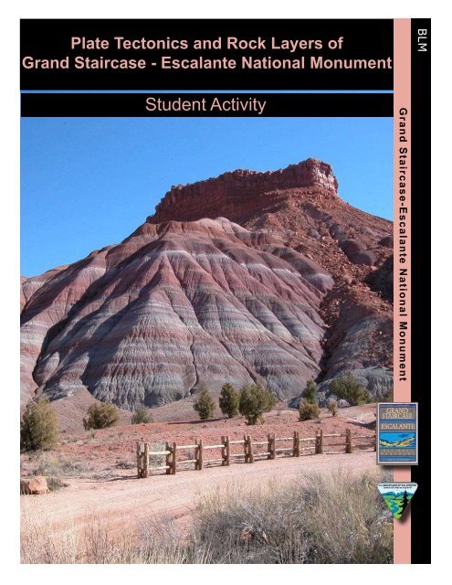
Plate Tectonics and the Rock Layers of Grand ... - Gsenmschool.org
Plate Tectonics and the Rock Layers of Grand ... - Gsenmschool.org
Plate Tectonics and the Rock Layers of Grand ... - Gsenmschool.org

Create successful ePaper yourself
Turn your PDF publications into a flip-book with our unique Google optimized e-Paper software.
<strong>Plate</strong> <strong>Tectonics</strong> <strong>and</strong> <strong>Rock</strong> <strong>Layers</strong> <strong>of</strong><br />
Gr<strong>and</strong> Staircase - Escalante National Monument<br />
BLM<br />
Student Activity<br />
Gr<strong>and</strong> Staircase-Escalante National Monument
Gr<strong>and</strong> Staircase-Escalante National Monument Geology Unit 2<br />
Student Activity<br />
<strong>Plate</strong> <strong>Tectonics</strong> <strong>and</strong> <strong>Rock</strong> <strong>Layers</strong> <strong>of</strong><br />
Gr<strong>and</strong> Staircase-Escalante National Monument<br />
Believe it or not, right now, no matter if you’re st<strong>and</strong>ing, sitting, or lying down, YOU ARE<br />
MOVING! Not only is our planet spinning in space, but <strong>the</strong> l<strong>and</strong> beneath you is drifting<br />
very, very slowly as it floats on a molten mantle at <strong>the</strong> center <strong>of</strong> <strong>the</strong> Earth.<br />
The Monument’s present location is marked by a red square on <strong>the</strong> Paleomap 1 above.<br />
In Utah, Gr<strong>and</strong> Staircase-Escalante National Monument (GSENM) is moving westward a<br />
few centimeters per year – perhaps about <strong>the</strong> length <strong>of</strong> your thumb. This tiny motion may<br />
seem insignificant until you consider that this has been happening continuously for billions<br />
<strong>of</strong> years. The face <strong>of</strong> planet Earth has truly been reshaped throughout geologic time. You<br />
might say <strong>the</strong> Old Gal has had an extreme makeover!<br />
For more paleogeographic maps <strong>of</strong> <strong>the</strong> Earth today, with emphasis on North America <strong>and</strong><br />
<strong>the</strong> Southwest, check out <strong>the</strong>se sites from <strong>the</strong> Department <strong>of</strong> Geology at Nor<strong>the</strong>rn Arizona<br />
University.<br />
Paleogeography <strong>and</strong> Geologic Evolution <strong>of</strong> North America<br />
http://jan.ucc.nau.edu/~rcb7/nam.html<br />
Global Paleogeographic Views <strong>of</strong> Earth’s History – Late Precambrian to Present<br />
http://jan.ucc.nau.edu/~rcb7/000_present_3globes.jpg<br />
1 <strong>Plate</strong> tectonic maps <strong>and</strong> Continental drift animations by C.R. Scotese, PALEOMAP Project<br />
(www.scotese.com)<br />
1
Gr<strong>and</strong> Staircase-Escalante National Monument Geology Unit 2<br />
Student Activity<br />
Geographic Regions <strong>of</strong> GSENM<br />
The Monument is divided into three geographic sections:<br />
I. Gr<strong>and</strong> Staircase, to <strong>the</strong> west, is a l<strong>and</strong> <strong>of</strong> terraces <strong>and</strong> open benches that stair-step up<br />
from south to north<br />
II. Kaiparowits <strong>Plate</strong>au, in <strong>the</strong> center, is a region <strong>of</strong> high plateaus <strong>and</strong> predominantly<br />
Cretaceous age rocks.<br />
III. Escalante Canyons, to <strong>the</strong> east, are an area <strong>of</strong> deeply eroded, incised canyons.<br />
Escalante Canyon<br />
Kaiparowits <strong>Plate</strong>au<br />
Gr<strong>and</strong> Staircase<br />
2
Gr<strong>and</strong> Staircase-Escalante National Monument Geology Unit 2<br />
Student Activity<br />
Geologic Formations <strong>of</strong> GSENM<br />
Studying <strong>the</strong> geology <strong>of</strong> Gr<strong>and</strong> Staircase-Escalante National Monument is like reading a<br />
history book <strong>of</strong> <strong>the</strong> Mesozoic Era, its ancient environments, plants, <strong>and</strong> animals. Though <strong>the</strong><br />
Monument’s rock layers are predominantly from <strong>the</strong> Mesozoic, <strong>the</strong>re are layers on top <strong>and</strong><br />
bottom that formed in <strong>the</strong> Cenozoic <strong>and</strong> Paleozoic Eras, respectively. Altoge<strong>the</strong>r, <strong>the</strong> rock<br />
layers <strong>of</strong> <strong>the</strong> Monument reveal sediments <strong>and</strong> fossils deposited over 270 million years <strong>of</strong><br />
geologic time.<br />
The following information will focus on <strong>the</strong> “Gr<strong>and</strong> Staircase,” a series <strong>of</strong> five colorful cliffs<br />
rising from south to north, gaining over 5,000 feet <strong>of</strong> elevation.<br />
Pink Cliffs<br />
Gray Cliffs<br />
White Cliffs<br />
Vermilion Cliffs<br />
Chocolate Cliffs<br />
The Gr<strong>and</strong> Staircase from LeFevre Overlook, North Kaibab Forest<br />
Most formations are composed <strong>of</strong> several “members,” each having a unique time span, geology,<br />
<strong>and</strong> environmental history. The geologic information on <strong>the</strong>se pages has been simplified <strong>and</strong><br />
covers only <strong>the</strong> formations, not <strong>the</strong>ir members.<br />
Many <strong>of</strong> <strong>the</strong> rock formations are NOT equally distributed throughout <strong>the</strong> Monument. A<br />
prominent layer in <strong>the</strong> west may be absent in <strong>the</strong> east, or it may be replaced by ano<strong>the</strong>r<br />
formation <strong>of</strong> <strong>the</strong> same geologic age. These variations are noted in text <strong>and</strong> labeled “East” or<br />
“West” on <strong>the</strong> following pages.<br />
There are missing chapters in <strong>the</strong> story <strong>of</strong> <strong>the</strong> Gr<strong>and</strong> Staircase. These missing chapters, or<br />
missing rock layers, are called unconformities. Unconformities are areas where <strong>the</strong> rock for a<br />
particular age is no longer present in <strong>the</strong> local sequence <strong>of</strong> strata. Unconformities are included in<br />
3
Gr<strong>and</strong> Staircase-Escalante National Monument Geology Unit 2<br />
Student Activity<br />
this narrative. We’ll begin exploring <strong>the</strong> geology <strong>of</strong> <strong>the</strong> Gr<strong>and</strong> Staircase by starting at <strong>the</strong> bottom,<br />
with <strong>the</strong> oldest rock layers, <strong>and</strong> gradually moving up to <strong>the</strong> present, geologically speaking.<br />
I. Kaibab Formation – Pk<br />
Time formed<br />
<strong>Rock</strong><br />
Location<br />
Appearance:<br />
Special features<br />
Environment when<br />
formed<br />
Similar modern<br />
day habitats<br />
Missing rock layers<br />
~ 270 mya (million years ago); Paleozoic/Late Permian<br />
Fossiliferous <strong>and</strong> cherty limestone<br />
Southwest <strong>and</strong> eastern Monument<br />
Gray, 0-100 feet thick; mostly cliff forming<br />
Many invertebrate fossils; sinkholes. Kaibab limestone underlies<br />
much <strong>of</strong> <strong>the</strong> monument <strong>and</strong> forms <strong>the</strong> rim <strong>of</strong> <strong>the</strong> Gr<strong>and</strong> Canyon.<br />
Clear warm shallow tropical seas with scattered reefs. Corals,<br />
sponges, <strong>and</strong> shells <strong>of</strong> small animals were compressed <strong>and</strong> turned<br />
into stone<br />
Caribbean Sea<br />
An unconformity in <strong>the</strong> rock sequence occurs here. Also, a great<br />
extinction <strong>of</strong> 95% <strong>of</strong> all species happens at this time<br />
4
Gr<strong>and</strong> Staircase-Escalante National Monument Geology Unit 2<br />
Student Activity<br />
II. Moenkopi Formation – Trm<br />
Time formed<br />
<strong>Rock</strong><br />
Location<br />
Appearance:<br />
Special features<br />
Environment when<br />
formed<br />
Similar modern day<br />
habitats<br />
Missing rock layers<br />
~245 mya, Mesozoic/Early Triassic<br />
Limestone, shale, siltstone, <strong>and</strong> s<strong>and</strong>stone<br />
Sou<strong>the</strong>rn <strong>and</strong> eastern part <strong>of</strong> <strong>the</strong> Monument<br />
Red brown to brown; 440 to 1150 feet; cliff <strong>and</strong> slope-forming. The<br />
upper red member forms <strong>the</strong> lower part <strong>of</strong> <strong>the</strong> Chocolate Cliffs.<br />
These cliffs are not particularly prominent inside <strong>the</strong> Monument.<br />
Ripple marks, mud cracks, terrestrial <strong>and</strong> marine fossils; amphibian<br />
<strong>and</strong> reptile track ways (not dinosaurs), uranium <strong>and</strong> gold deposits<br />
are present though better represented in <strong>the</strong> Chinle formation.<br />
Coastal tidal flats. The shoreline shifted back <strong>and</strong> forth, giving a mix<br />
<strong>of</strong> shallow sea <strong>and</strong> arid coastal deposits. Daily tides created ripple<br />
marks. Utah lay close to <strong>the</strong> equator at this time.<br />
Persian Gulf<br />
Ano<strong>the</strong>r unconformity in <strong>the</strong> rock sequence occurs here.<br />
5
Gr<strong>and</strong> Staircase-Escalante National Monument Geology Unit 2<br />
Student Activity<br />
III. Chinle Formation – Trc<br />
Time formed<br />
<strong>Rock</strong><br />
Location<br />
Appearance:<br />
Special features<br />
Environment when<br />
formed<br />
Similar modern day<br />
habitats<br />
Missing rock layers<br />
Time formed<br />
<strong>Rock</strong><br />
Location<br />
Appearance:<br />
Special features<br />
Environment when<br />
formed<br />
Similar modern day<br />
habitats<br />
~210 mya<br />
Shale, mudstone, s<strong>and</strong>stone, <strong>and</strong> some conglomerates<br />
Sou<strong>the</strong>rn <strong>and</strong> Eastern part <strong>of</strong> <strong>the</strong> Monument<br />
Gray, green, purple, red. 425 to 930 feet. The Petrified Forest<br />
member <strong>of</strong> <strong>the</strong> Chinle is slope-forming <strong>and</strong> <strong>of</strong>ten makes multi-hued<br />
rounded mounds <strong>and</strong> badl<strong>and</strong>s. The lower part <strong>of</strong> <strong>the</strong> Chinle, <strong>the</strong><br />
Shinarump member, is ledge-forming, <strong>and</strong> created <strong>the</strong> upper portions<br />
<strong>of</strong> <strong>the</strong> Chocolate Cliffs. The top piece <strong>of</strong> <strong>the</strong> Moenkopi <strong>and</strong> <strong>the</strong><br />
adjacent bottom pieced <strong>of</strong> <strong>the</strong> Chinle toge<strong>the</strong>r make up <strong>the</strong> Chocolate<br />
Cliffs.<br />
Dinosaurs <strong>and</strong> <strong>the</strong>ir tracks appear. The Petrified Forest member is<br />
famous for petrified wood. The upper Chinle erodes into soils on<br />
which few plants can survive. Its clays swell dramatically when wet,<br />
making road building difficult, <strong>and</strong> necessitates frequent highway<br />
repairs.<br />
Upl<strong>and</strong> conifer forests with partly-thick ash falls from area<br />
volcanoes. Huge conifers later fossilized into petrified wood.<br />
Upl<strong>and</strong> forests <strong>of</strong> Sou<strong>the</strong>rn Mexico<br />
Yes, ano<strong>the</strong>r unconformity…<br />
IV. East-Wingate S<strong>and</strong>stone – Jw<br />
~200 mya, Mesozoic/Early Jurassic<br />
Windblown s<strong>and</strong>stone<br />
Only on <strong>the</strong> east side <strong>of</strong> <strong>the</strong> Monument<br />
Red brown; 250 to 350 feet; cliff former<br />
Cross-bedding. In <strong>the</strong> western Monument <strong>the</strong> Moenave, which<br />
formed in a wetter environment, fills <strong>the</strong> Wingate’s time frame.<br />
S<strong>and</strong> desert. Winds piled <strong>the</strong> quartz s<strong>and</strong> into dunes, preserving <strong>the</strong><br />
cross-bedding<br />
A medium-sized desert like that on <strong>the</strong> Saudi Arabian Peninsula.<br />
6
Gr<strong>and</strong> Staircase-Escalante National Monument Geology Unit 2<br />
Student Activity<br />
Time formed<br />
<strong>Rock</strong><br />
Location<br />
Appearance:<br />
Special features<br />
Environment when<br />
formed<br />
Similar modern day<br />
habitats<br />
IV. West-Moenave Formation – Jmv<br />
~200 mya, Mesozoic/Early Jurassic<br />
S<strong>and</strong>stone, siltstone, mudstone, shale<br />
Southwest part <strong>of</strong> <strong>the</strong> Monument<br />
Orange-red, 200 to 400 feet, moderate cliff former<br />
The Moenave forms <strong>the</strong> lower <strong>and</strong> middle parts <strong>of</strong> <strong>the</strong> Vermilion<br />
Cliffs. In <strong>the</strong> eastern Monument, <strong>the</strong> Wingate S<strong>and</strong>stone fills <strong>the</strong><br />
Moenave’s time frame.<br />
Varied. Terrestrial stream <strong>and</strong> lake deposits. Some formed in lakecovered<br />
flood plains <strong>and</strong> mudflats on which small rivers flowed.<br />
Kayena Africa<br />
V. Kayenta Formation –Jk<br />
Kayenta<br />
Moenave<br />
Time formed<br />
<strong>Rock</strong><br />
Location<br />
Appearance:<br />
Special features<br />
Environment when<br />
formed<br />
Similar modern day<br />
habitats<br />
193 mya, Mesozoic/Jurassic<br />
S<strong>and</strong>stone, siltstone, shale<br />
Sou<strong>the</strong>rn <strong>and</strong> eastern part <strong>of</strong> <strong>the</strong> Monument<br />
Reddish brown, 150 to 300 feet, upper component <strong>of</strong> <strong>the</strong> Vermilion<br />
Cliffs. Many places in <strong>the</strong> Vermilion Cliffs show part <strong>of</strong> <strong>the</strong><br />
Moenave at <strong>the</strong>ir bottom, <strong>and</strong> sometimes a tongue <strong>of</strong> <strong>the</strong> Navajo<br />
S<strong>and</strong>stone at <strong>the</strong>ir top. But in <strong>the</strong> east part <strong>of</strong> <strong>the</strong> Monument, <strong>the</strong><br />
Kayenta is generally a bench former.<br />
Dinosaur track ways. Influenced historic routes <strong>of</strong> travel, siting <strong>of</strong><br />
towns like Kayenta, Arizona.<br />
Mostly s<strong>and</strong>y streams. Rivers <strong>and</strong> streams deposited s<strong>and</strong> <strong>and</strong> silt<br />
sediments as <strong>the</strong>y flowed through dry savannas dotted with trees.<br />
Yearly flooding created flood-plains <strong>and</strong> spread out fine sediments.<br />
Intermixed are lake deposits <strong>and</strong> minor windblown s<strong>and</strong> dunes.<br />
Kenya, Africa<br />
7
Gr<strong>and</strong> Staircase-Escalante National Monument Geology Unit 2<br />
Student Activity<br />
VI. Navajo S<strong>and</strong>stone – Jn<br />
Time formed<br />
<strong>Rock</strong><br />
Appearance:<br />
Special features<br />
Environment when<br />
formed<br />
Similar modern day<br />
habitats<br />
Missing rock layers<br />
~185 mya, Mesozoic/ Middle Jurassic<br />
Windblown cross-bedded s<strong>and</strong>stone<br />
2<br />
Red, orange, yellow, brown, <strong>of</strong>ten bleached almost white , 1000 to<br />
1500 feet. Magnificent cliff-former - makes <strong>the</strong> famous White Cliffs<br />
Very dramatic cliffs, high angle cross-bedded s<strong>and</strong>stone reveals <strong>the</strong><br />
fossil desert; slot canyons; Moqui marbles.<br />
Great dune desert, formed by winds over a long period <strong>of</strong> time. As<br />
<strong>the</strong> dunes marched southward in this hot, arid desert, s<strong>and</strong> was<br />
deposited on <strong>the</strong> downwind face <strong>of</strong> <strong>the</strong> dunes, creating <strong>and</strong><br />
preserving cross-bedding.<br />
Sahara Desert, Africa. The Navajo desert was even larger than <strong>the</strong><br />
Sahara!<br />
Ano<strong>the</strong>r unconformity<br />
2 Chan, Marjorie A. <strong>and</strong> William T. Parry. 2003. Rainbow <strong>of</strong> <strong>Rock</strong>s: Mysteries <strong>of</strong> S<strong>and</strong>stone Colors <strong>and</strong> Concretions in<br />
Colorado <strong>Plate</strong>au Canyon Country. Public Information Series 77, Utah Geological Survey.<br />
8
Gr<strong>and</strong> Staircase-Escalante National Monument Geology Unit 2<br />
Student Activity<br />
VII. Carmel Jc <strong>and</strong> Page Jp Formations<br />
Time formed<br />
<strong>Rock</strong><br />
Appearance:<br />
Special features<br />
Environment when<br />
formed<br />
Similar modern day<br />
habitats<br />
~ 170 mya, Mesozoic/Late Jurassic<br />
Silty limestone, shaly s<strong>and</strong>stone, shale, minor gypsum<br />
Red, white, brown; 90 to 200 feet. Composed <strong>of</strong> many different<br />
member layers, some form cliffs, o<strong>the</strong>rs, slopes. Notable member is<br />
<strong>the</strong> Thous<strong>and</strong> Pockets Tongue <strong>of</strong> <strong>the</strong> Page S<strong>and</strong>stone, composed <strong>of</strong><br />
windblown, cross-bedded s<strong>and</strong>stone.<br />
Alabaster gypsum, crinoid fossils.<br />
Marine <strong>and</strong> coastal environments along which huge shallow bays <strong>of</strong><br />
seawater, cut <strong>of</strong>f from <strong>the</strong> neighboring ocean, evaporated leaving<br />
layers <strong>of</strong> gypsum salts. The Carmel represents a time when a seaway<br />
entered <strong>the</strong> area from <strong>the</strong> North. The Page S<strong>and</strong>stone formed from<br />
desert dunes that pushed into <strong>the</strong> area from <strong>the</strong> east.<br />
Persian Gulf<br />
Time formed<br />
<strong>Rock</strong><br />
Appearance:<br />
Special features<br />
Environment when<br />
formed<br />
Similar modern day<br />
habitats<br />
Missing rock layers<br />
VIII. Entrada S<strong>and</strong>stone –Je<br />
~165 mya, Mesozoic/ Late Jurassic<br />
S<strong>and</strong>stone, siltstone<br />
Red, gray, white; 200 to 800 feet; some cliff forming<br />
The Entrada forms <strong>the</strong> lower part <strong>of</strong> <strong>the</strong> Gray Cliffs; can erode into<br />
“slick rock” shapes; dinosaur track ways.<br />
Partly windblown s<strong>and</strong> dunes <strong>and</strong> partly tidal flat; sabhka <strong>and</strong> beach<br />
type deposits. At times <strong>the</strong> ocean encroached into <strong>the</strong> area, creating<br />
marine s<strong>and</strong>stones <strong>and</strong> siltstones.<br />
A s<strong>and</strong>y desert along a beach, similar to beaches along <strong>the</strong> Persian<br />
Gulf.<br />
Ano<strong>the</strong>r unconformity<br />
9
Gr<strong>and</strong> Staircase-Escalante National Monument Geology Unit 2<br />
Student Activity<br />
Time formed<br />
<strong>Rock</strong><br />
Appearance:<br />
Special features<br />
Environment when<br />
formed<br />
Similar modern day<br />
habitats<br />
Missing rock layers<br />
VIII. Eastern – Morrison Formation – Jm<br />
~150 mya, Mesozoic/Late Jurassic<br />
River deposited s<strong>and</strong>stone, mudstone<br />
Gray, blue, red/purple/green <strong>and</strong> yellow-brown streaks; 0 to 900<br />
feet; some members cliff forming, o<strong>the</strong>rs slope-forming.<br />
Low grade uranium; in nor<strong>the</strong>rn Utah, this layer has Dinosaur<br />
National Park’s fossils<br />
Lowl<strong>and</strong>s with rivers, streams, <strong>and</strong> <strong>the</strong>ir associated s<strong>and</strong>bars;<br />
floodplains <strong>and</strong> gravel beds (conglomerates)<br />
Braided rivers <strong>and</strong> streams similar to those coming <strong>of</strong>f <strong>the</strong> Andes<br />
Mountains in South America<br />
Ano<strong>the</strong>r unconformity<br />
IX. Dakota Formation –K<br />
Time formed<br />
<strong>Rock</strong><br />
Appearance:<br />
Special features<br />
Environment when<br />
formed<br />
Similar modern day<br />
habitats<br />
~95 mya, Mesozoic/Late Cretaceous.<br />
S<strong>and</strong>stone, mudstone, shale, conglomerate, <strong>and</strong> coal.<br />
Brown, yellow, gray; 0-250 feet, mostly slope-forming.<br />
Some coal present. Dakota S<strong>and</strong>stone is one <strong>of</strong> <strong>the</strong> most<br />
widespread formations in <strong>the</strong> western United States. It forms <strong>the</strong><br />
upper part <strong>of</strong> <strong>the</strong> Gray Cliffs, which are not as visually striking as<br />
<strong>the</strong> White Cliffs below <strong>and</strong> Pink Cliffs above. The Gray Cliffs lack<br />
towering, massive cliff faces, <strong>and</strong> have a ra<strong>the</strong>r rounded or eroded<br />
appearance.<br />
Varied. Shallow marine <strong>and</strong> near shore swamps. The Western<br />
Interior Seaway was advancing into <strong>the</strong> North American Continent,<br />
extending from <strong>the</strong> Gulf <strong>of</strong> Mexico to <strong>the</strong> Arctic, depositing belowsurface<br />
s<strong>and</strong>stone <strong>and</strong> o<strong>the</strong>r layers. Over <strong>the</strong> next tens <strong>of</strong> millions <strong>of</strong><br />
years, <strong>the</strong> sea would rise <strong>and</strong> fall, sometimes leaving marine<br />
sediments, <strong>and</strong> o<strong>the</strong>r times retreating to allow terrestrial<br />
environments. Coal was formed in lagoon swamps with lush plant<br />
growth.<br />
Coastlines <strong>of</strong> Florida or Louisiana.<br />
10
Gr<strong>and</strong> Staircase-Escalante National Monument Geology Unit 2<br />
Student Activity<br />
X. Tropic Shale – Kt<br />
Straight Cliffs<br />
Tropic Shale<br />
Time formed<br />
<strong>Rock</strong><br />
Appearance:<br />
Special features<br />
Environment when<br />
formed<br />
Similar modern day<br />
habitats<br />
~ 93 mya, Mesozoic/ Late Cretaceous<br />
Shale, clay<br />
Dark gray, blue gray; 500-700 feet; a slope-former with slumps <strong>and</strong><br />
l<strong>and</strong>slides.<br />
Very few plants grow in its soil; badl<strong>and</strong>s have a “surface-<strong>of</strong>-<strong>the</strong>moon”<br />
feel; slippery when wet; many fossils including ammonites,<br />
mollusks, sharks, pliosaurs, turtles, <strong>and</strong> more.<br />
Part <strong>of</strong> <strong>the</strong> Western Interior Seaway. Floor <strong>of</strong> a shallow sea, not<br />
right against <strong>the</strong> shoreline.<br />
Gulf <strong>of</strong> Mexico, away from <strong>the</strong> coast.<br />
11
Gr<strong>and</strong> Staircase-Escalante National Monument Geology Unit 2<br />
Student Activity<br />
XI. Straight Cliffs Formation – Ks<br />
Time formed<br />
<strong>Rock</strong><br />
Appearance:<br />
Special features<br />
Environment when<br />
formed<br />
Similar modern day<br />
habitats<br />
Time formed<br />
<strong>Rock</strong><br />
Appearance:<br />
Special features<br />
Environment when<br />
formed<br />
Similar modern day<br />
habitats<br />
~ 85 mya, Mesozoic/ Late Cretaceous<br />
S<strong>and</strong>stone, shale with coal<br />
Yellow-gray, white; 900 to 1800 feet; cliff-forming, some slopes;<br />
comprises <strong>the</strong> Straight Cliffs located mostly in <strong>the</strong> northwest <strong>and</strong><br />
south central portions <strong>of</strong> <strong>the</strong> Monument.<br />
Coal seams, some burning underground (Smoky Mountain, Burning<br />
Hills); “clinker” rocks formed by natural coal fires.<br />
Coastal swamps, warm lagoons, marshy seashores. Vast amounts <strong>of</strong><br />
<strong>org</strong>anic material, mostly plants created perfect conditions for coal<br />
formation.<br />
Delta <strong>and</strong> coast <strong>of</strong> Louisiana.<br />
XII. Wahweap Formation – Kw<br />
~80 mya, Mesozoic/Late Cretaceous<br />
S<strong>and</strong>stone, shale, mudstone<br />
Yellowish-gray, buff; 800 to 1100 feet; top two members form cliffs<br />
<strong>and</strong> ledges, its third <strong>and</strong> lowest member form slopes. It is best<br />
represented in <strong>the</strong> eastern part <strong>of</strong> <strong>the</strong> Monument.<br />
Fossils, dramatic cliffs.<br />
Swampy lowl<strong>and</strong>s. These were lush, humid areas with<br />
floodplains, slow rivers, <strong>and</strong> shallow lakes.<br />
Inl<strong>and</strong> Louisiana<br />
12
Gr<strong>and</strong> Staircase-Escalante National Monument Geology Unit 2<br />
Student Activity<br />
XII. East Kaiparowits Formation – Kk<br />
Time formed<br />
<strong>Rock</strong><br />
Appearance:<br />
Special features<br />
Environment when<br />
formed<br />
Similar modern day<br />
habitats<br />
Missing rock layers<br />
~75 mya, Mesozoic to Late Cretaceous<br />
Shaly s<strong>and</strong>stone<br />
Greenish-gray, blue-gray; 2000 to 3000 feet; forms badl<strong>and</strong>s <strong>and</strong><br />
slopes. Creates <strong>the</strong> area called “The Blues.”<br />
New dinosaur discoveries <strong>and</strong> diverse faunas; tremendous<br />
deposition rates <strong>of</strong> sediments from <strong>the</strong> Sevier Mountains.<br />
Freshwater or brackish lakes <strong>and</strong> nearby flatl<strong>and</strong>s, fur<strong>the</strong>r from <strong>the</strong><br />
sea than during formation <strong>of</strong> Wahweap.<br />
Broad shallow lakes; close to <strong>the</strong> sea where tides could still influence<br />
deposition.<br />
Ano<strong>the</strong>r unconformity in <strong>the</strong> rock sequence occurs here, <strong>and</strong><br />
ano<strong>the</strong>r mass extinction happens, this time killing <strong>of</strong>f 75% <strong>of</strong> all<br />
species.<br />
13
Gr<strong>and</strong> Staircase-Escalante National Monument Geology Unit 2<br />
Student Activity<br />
XIII. Claron Formation – Tc<br />
Time formed<br />
<strong>Rock</strong><br />
Location<br />
Appearance:<br />
Special features<br />
Environment when<br />
formed<br />
Similar modern day<br />
habitats<br />
~50 mya, Cenozoic/Tertiary<br />
Limestone, s<strong>and</strong>stone, siltstone<br />
This formation is mostly in Dixie National Forest <strong>and</strong> Bryce<br />
National Park.<br />
Pale orange, yellow, pink white; 1000 to 1600 feet; wea<strong>the</strong>rs into<br />
cliffs, spires, columns <strong>and</strong> pinnacles. Forms <strong>the</strong> Pink Cliffs <strong>of</strong> <strong>the</strong><br />
Gr<strong>and</strong> Staircase.<br />
Rapid erosion forms “hoodoos,” very colorful cliffs.<br />
In a very large freshwater lake, sediments collected <strong>and</strong> consolidated<br />
to form <strong>the</strong> Claron Formation. The pink member <strong>of</strong> <strong>the</strong> Claron is<br />
predominantly river channel, flood plain, <strong>and</strong> lake deposits.<br />
A large fresh water lake with high inflow, but little outflow.<br />
Postscript<br />
Paleogene time <strong>and</strong> Neogene time deposits are scattered throughout <strong>the</strong> Monument. These<br />
materials rest on top <strong>of</strong> exposed rock strata <strong>and</strong> include:<br />
• Lava flows <strong>and</strong> cinder cones form basalt, tuff, <strong>and</strong> ash layers.<br />
• Wind blows s<strong>and</strong> into surface dunes, especially near eroding s<strong>and</strong>stone.<br />
• Water washes debris, s<strong>and</strong>, <strong>and</strong> gravel into streambeds, terraces, <strong>and</strong> floodplains.<br />
• Mass wasting creates talus slopes <strong>and</strong> rock falls.<br />
• Wet shales collapse in l<strong>and</strong>slides <strong>and</strong> slumps.<br />
• Glaciers during <strong>the</strong> Pleistocene added materials later moved by water erosion.<br />
And it Continues<br />
Monument l<strong>and</strong>s <strong>and</strong> <strong>the</strong> entire Colorado <strong>Plate</strong>au continue to rise in elevation. Tributaries to <strong>the</strong><br />
Colorado River keep wearing deeper into <strong>the</strong> canyons. Faults still move <strong>and</strong> erosion continues to<br />
form windblown <strong>and</strong> waterborne deposits. Even human activities affect <strong>the</strong> geologic face <strong>of</strong><br />
GSENM. Its story is still being written.<br />
14
Gr<strong>and</strong> Staircase-Escalante National Monument Geology Unit 2<br />
Student Activity<br />
Geography <strong>of</strong> Ancient Earth<br />
Step 1: How to interpret paleomaps<br />
• Find <strong>the</strong> red dot marking <strong>the</strong> location <strong>of</strong> Gr<strong>and</strong> Staircase Escalante National Monument<br />
on <strong>the</strong> four Paleomaps 3 below.<br />
• Notice that each <strong>of</strong> <strong>the</strong>se maps represents a different Period in geologic time. Below<br />
each map is brief description <strong>of</strong> <strong>the</strong> location <strong>of</strong> <strong>the</strong> Monument.<br />
• Read each description <strong>and</strong> familiarize yourself with what to look for as you read<br />
paleogeographic maps.<br />
I. Late Permian Era~255 mya<br />
The Monument is underwater, in a warm tropical sea. How can you tell it’s a tropical sea? Check<br />
out its location in relation to <strong>the</strong> Equator.<br />
II. Mesozoic Era – Triassic Period~237 mya<br />
The Monument is located on <strong>the</strong> western shoreline <strong>of</strong> <strong>the</strong> continent Pangea. The climate would<br />
still be tropical due to its proximity to <strong>the</strong> Equator.<br />
3 <strong>Plate</strong> tectonic maps <strong>and</strong> Continental drift animations by C. R. Scotese, PALEOMAP Project<br />
(www.scotese.com)<br />
15
Gr<strong>and</strong> Staircase-Escalante National Monument Geology Unit 2<br />
Student Activity<br />
III. Mesozoic Era – Early Jurassic Period ~195 mya<br />
The Monument is located inl<strong>and</strong>, in a huge dune field. Tropical westerlies bring s<strong>and</strong> down from<br />
<strong>the</strong> North. Climate is less tropical away from <strong>the</strong> Equator.<br />
IV. Mesozoic Era – Late Cretaceous Period ~ 94 mya<br />
The Monument is again located on <strong>the</strong> shoreline, this time on <strong>the</strong> east coast <strong>of</strong> an inl<strong>and</strong> sea <strong>and</strong><br />
fur<strong>the</strong>r still from <strong>the</strong> Equator.<br />
Step 2<br />
Use online paleogeographic maps to follow <strong>the</strong> tectonic movement <strong>of</strong> GSENM <strong>and</strong> correlate its<br />
different geographic locations with <strong>the</strong> environments that existed when major rock layers were<br />
formed.<br />
I. Follow <strong>the</strong> internet links to view a series <strong>of</strong> Paleogeographic Maps for North America from <strong>the</strong><br />
Department <strong>of</strong> Geology at Nor<strong>the</strong>rn Arizona University.<br />
16
Gr<strong>and</strong> Staircase-Escalante National Monument Geology Unit 2<br />
Student Activity<br />
II. Locate <strong>the</strong> state <strong>of</strong> Utah on each map <strong>and</strong> find <strong>the</strong> area that would be <strong>the</strong> Monument.<br />
Outline <strong>of</strong> <strong>the</strong> State <strong>of</strong> Utah<br />
o<br />
Gr<strong>and</strong> Staircase-Escalante National Monument<br />
III. For each geologic period:<br />
A. Analyze <strong>the</strong> Monument’s geographic location <strong>and</strong> form a hypo<strong>the</strong>sis about <strong>the</strong> type<br />
<strong>of</strong> environment that existed.<br />
B. Check your hypo<strong>the</strong>sis by reading about <strong>the</strong> rock layer(s) from earlier in this activity.<br />
Question 1<br />
In <strong>the</strong> space below each geologic period write a brief synopsis <strong>of</strong> <strong>the</strong> environment that existed<br />
<strong>and</strong> list <strong>the</strong> rock layer(s) formed.<br />
a) Middle Permian ~ 275 mya http://jan.ucc.nau.edu/~rcb7/namP275.jpg<br />
___________________________________________________________________________<br />
___________________________________________________________________________<br />
___________________________________________________________________________<br />
___________________________________________________________________________<br />
b) Early Triassic ~ 245 mya http://jan.ucc.nau.edu/~rcb7/namTr245.jpg<br />
___________________________________________________________________________<br />
___________________________________________________________________________<br />
___________________________________________________________________________<br />
___________________________________________________________________________<br />
c) Late Triassic ~ 210 mya http://jan.ucc.nau.edu/~rcb7/namTr210.jpg<br />
___________________________________________________________________________<br />
___________________________________________________________________________<br />
___________________________________________________________________________<br />
___________________________________________________________________________<br />
d) Early Jurassic ~ 195 mya http://jan.ucc.nau.edu/~rcb7/namJ195.jpg<br />
___________________________________________________________________________<br />
___________________________________________________________________________<br />
___________________________________________________________________________<br />
___________________________________________________________________________<br />
e) Middle Jurassic ~ 170 mya http://jan.ucc.nau.edu/~rcb7/namJ170.jpg<br />
17
Gr<strong>and</strong> Staircase-Escalante National Monument Geology Unit 2<br />
Student Activity<br />
___________________________________________________________________________<br />
___________________________________________________________________________<br />
___________________________________________________________________________<br />
___________________________________________________________________________<br />
f) Late Jurassic ~ 150 mya http://jan.ucc.nau.edu/~rcb7/namJ150.jpg<br />
___________________________________________________________________________<br />
___________________________________________________________________________<br />
___________________________________________________________________________<br />
___________________________________________________________________________<br />
g) Early Cretaceous ~ 100 mya http://jan.ucc.nau.edu/~rcb7/namK100.jpg<br />
___________________________________________________________________________<br />
___________________________________________________________________________<br />
___________________________________________________________________________<br />
___________________________________________________________________________<br />
h) Late Cretaceous ~ 85 mya http://jan.ucc.nau.edu/~rcb7/namK85.jpg<br />
___________________________________________________________________________<br />
___________________________________________________________________________<br />
___________________________________________________________________________<br />
___________________________________________________________________________<br />
i) Tertiary ~ 65 mya http://jan.ucc.nau.edu/~rcb7/namKT65.jpg<br />
___________________________________________________________________________<br />
___________________________________________________________________________<br />
___________________________________________________________________________<br />
___________________________________________________________________________<br />
j) Paleogene ~ 50 mya http://jan.ucc.nau.edu/~rcb7/namPe50.jpg<br />
___________________________________________________________________________<br />
___________________________________________________________________________<br />
___________________________________________________________________________<br />
___________________________________________________________________________<br />
18
Gr<strong>and</strong> Staircase-Escalante National Monument Geology Unit 2<br />
Student Activity<br />
Ancient Environments<br />
Following are illustrations <strong>of</strong> nine different environments that existed while <strong>the</strong> rock layers <strong>of</strong><br />
<strong>the</strong> Monument were being formed in <strong>the</strong> geologic past. These pictures do not cover all <strong>of</strong> <strong>the</strong><br />
different environments, just a few.<br />
Use information from earlier in <strong>the</strong> activity to identify <strong>the</strong> geologic time period <strong>and</strong> <strong>the</strong> rock<br />
formation that could have been made when <strong>the</strong> environment looked like <strong>the</strong> illustrations. Write<br />
<strong>the</strong> name(s) <strong>of</strong> <strong>the</strong> rock layers <strong>and</strong> <strong>the</strong> geologic time that you think each illustration represents.<br />
Question 2<br />
a) b)<br />
<strong>Rock</strong> Formation:_____________________ <strong>Rock</strong> Formation:_____________________<br />
Geologic Time (mya):_________________ Geologic Time (mya):_________________<br />
c)<br />
<strong>Rock</strong> Formation:_____________________<br />
Geologic Time (mya):_________________<br />
d)<br />
<strong>Rock</strong> Formation:_____________________<br />
Geologic Time (mya):_________________<br />
19
Gr<strong>and</strong> Staircase-Escalante National Monument Geology Unit 2<br />
Student Activity<br />
e)<br />
<strong>Rock</strong> Formation:___________________________<br />
Geologic Time (mya):_______________________<br />
f)<br />
<strong>Rock</strong> Formation:________________<br />
Geologic Time (mya):____________<br />
g) h)<br />
<strong>Rock</strong> Formation:_____________________<br />
<strong>Rock</strong> Formation:_____________________<br />
Geologic Time (mya):_________________<br />
Geologic Time (mya):_________________<br />
i)<br />
<strong>Rock</strong> Formation:_____________________________<br />
Geologic Time (mya):_________________________<br />
20
Gr<strong>and</strong> Staircase-Escalante National Monument Geology Unit 2<br />
Student Activity<br />
Vocabulary<br />
Cenozoic<br />
Belonging or relating to <strong>the</strong> most recent era <strong>of</strong> geological<br />
time, covering <strong>the</strong> period from <strong>the</strong> present to about 65<br />
million years ago, during which modern plants <strong>and</strong> animals<br />
evolved.<br />
Formations<br />
Jurassic<br />
Limestone<br />
Members<br />
Mesozoic<br />
Mudstone<br />
Paleozoic<br />
Sabhka<br />
S<strong>and</strong>stone<br />
Shale<br />
Siltstone<br />
Unit <strong>of</strong> rock consisting <strong>of</strong> a succession <strong>of</strong> strata or an igneous<br />
intrusion.<br />
The period <strong>of</strong> geologic time during which dinosaurs<br />
flourished <strong>and</strong> birds <strong>and</strong> mammals first appeared,<br />
extending from 200 million years to 145 million years ago.<br />
Sedimentary rock formed from <strong>the</strong> skeletons <strong>and</strong> shells <strong>of</strong><br />
marine <strong>org</strong>anisms that consists chiefly <strong>of</strong> calcium carbonate<br />
<strong>and</strong> is used widely in construction <strong>and</strong> in making lime <strong>and</strong><br />
cement.<br />
A division <strong>of</strong> a formation, generally <strong>of</strong> distinct lithologic<br />
character or <strong>of</strong> only local extent.<br />
Belonging to or dating from an era <strong>of</strong> geologic time 250 to<br />
65 million years ago, between <strong>the</strong> Paleozoic <strong>and</strong> Cenozoic<br />
Eras, when dinosaurs, birds, <strong>and</strong> flowering plants first<br />
appeared.<br />
A sedimentary rock formed from mud, similar to shale but<br />
with less developed lamination.<br />
The Era <strong>of</strong> geologic time when fish, insects, amphibians,<br />
reptiles, <strong>and</strong> l<strong>and</strong> plants first appeared, about 550 million<br />
to 250 million years ago.<br />
A coastal environment in an arid climate where evaporation<br />
rates are high. The term is also applied to interior flat areas<br />
where, from ei<strong>the</strong>r deflation or evaporation, saline minerals<br />
are present (salt flat).<br />
Sedimentary rock made up <strong>of</strong> s<strong>and</strong> particles, mostly quartz,<br />
bound toge<strong>the</strong>r by a mineral cement, along with some<br />
feldspar, mica, <strong>and</strong> rock debris.<br />
A dark fine-grained sedimentary rock composed <strong>of</strong> layers<br />
<strong>of</strong> compressed clay, silt, or mud.<br />
A form <strong>of</strong> fine-grained s<strong>and</strong>stone consisting <strong>of</strong> compressed<br />
silt.<br />
21
Gr<strong>and</strong> Staircase-Escalante National Monument Geology Unit 2<br />
Student Activity<br />
Strata<br />
Plural <strong>of</strong> stratum, any <strong>of</strong> several parallel layer levels.<br />
Unconformity<br />
A surface <strong>of</strong> erosion, or non-deposition, between younger<br />
strata <strong>and</strong> older rocks.<br />
22