HYDROGEOLOGICAL MAP OF LESSINI MOUNTAINS ... - CC-WaterS
HYDROGEOLOGICAL MAP OF LESSINI MOUNTAINS ... - CC-WaterS
HYDROGEOLOGICAL MAP OF LESSINI MOUNTAINS ... - CC-WaterS

You also want an ePaper? Increase the reach of your titles
YUMPU automatically turns print PDFs into web optimized ePapers that Google loves.
CARTA IDROGEOLOGICA DEI MONTI <strong>LESSINI</strong> - <strong>HYDROGEOLOGICAL</strong> <strong>MAP</strong> <strong>OF</strong> <strong>LESSINI</strong> <strong>MOUNTAINS</strong><br />
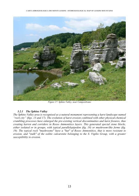
Figure 17: Sphinx Valley, near Camposilvano<br />
3.2.1 The Sphinx Valley<br />
The Sphinx Valley area is recognised as a natural monument representing a karst landscape named<br />
“rock city” (figs. 13 and 17). The evolution of karst erosion combined with other physical-chemical<br />
crumbling processes have enlarged the pre-existing vertical discontinuities and karst fissures, thus<br />
creating karren and corridors in Rosso Ammonitico layers. This generated special stone blocks,<br />
either isolated or in groups, with typical parallelepipedon (fig. 18) or mushroom-like forms (fig.<br />
19). The typical rock "mushrooms" have a "hat" of Rosso Ammonitico, that is more resistant to<br />
erosion, and "stalk" of the oolitic calcarenite belonging to the S. Vigilio Group, with a greater<br />
susceptibility to erosion.<br />
13