NON-RESIDENTIAL MASTER SUBDIVISION PLAN ... - Town of Apex
NON-RESIDENTIAL MASTER SUBDIVISION PLAN ... - Town of Apex
NON-RESIDENTIAL MASTER SUBDIVISION PLAN ... - Town of Apex

Create successful ePaper yourself
Turn your PDF publications into a flip-book with our unique Google optimized e-Paper software.
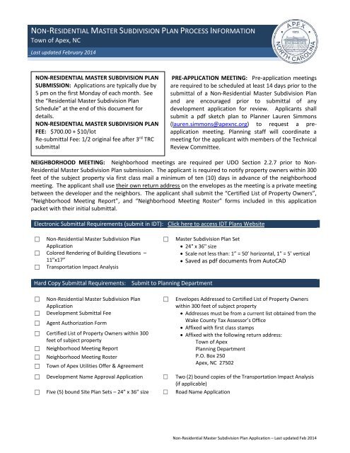
<strong>NON</strong>-<strong>RESIDENTIAL</strong> <strong>MASTER</strong> <strong>SUBDIVISION</strong> <strong>PLAN</strong> PROCESS INFORMATION<br />
<strong>Town</strong> <strong>of</strong> <strong>Apex</strong>, NC<br />
Last updated February 2014<br />
<strong>NON</strong>-<strong>RESIDENTIAL</strong> <strong>MASTER</strong> <strong>SUBDIVISION</strong> <strong>PLAN</strong><br />
SUBMISSION: Applications are typically due by<br />
5 pm on the first Monday <strong>of</strong> each month. See<br />
the “Residential Master Subdivision Plan<br />
Schedule” at the end <strong>of</strong> this document for<br />
details.<br />
<strong>NON</strong>-<strong>RESIDENTIAL</strong> <strong>MASTER</strong> <strong>SUBDIVISION</strong> <strong>PLAN</strong><br />
FEE: $700.00 + $10/lot<br />
Re-submittal Fee: 1/2 original fee after 3 rd TRC<br />
submittal<br />
PRE-APPLICATION MEETING: Pre-application meetings<br />
are required to be scheduled at least 14 days prior to the<br />
submittal <strong>of</strong> a Non-Residential Master Subdivision Plan<br />
and are encouraged prior to submittal <strong>of</strong> any<br />
development application for review. Applicants shall<br />
submit a pdf sketch plan to Planner Lauren Simmons<br />
(lauren.simmons@apexnc.org) to request a preapplication<br />
meeting. Planning staff will coordinate a<br />
meeting for the applicant with members <strong>of</strong> the Technical<br />
Review Committee.<br />
NEIGHBORHOOD MEETING: Neighborhood meetings are required per UDO Section 2.2.7 prior to Non-<br />
Residential Master Subdivision Plan submission. The applicant is required to notify property owners within 300<br />
feet <strong>of</strong> the subject property via first class mail a minimum <strong>of</strong> ten (10) days in advance <strong>of</strong> the neighborhood<br />
meeting. The applicant shall use their own return address on the envelopes as the meeting is a private meeting<br />
between the developer and the neighbors. The applicant shall submit the “Certified List <strong>of</strong> Property Owners”,<br />
“Neighborhood Meeting Report”, and “Neighborhood Meeting Roster” forms included in this application<br />
packet with their initial submittal.<br />
Electronic Submittal Requirements (submit in IDT): Click here to access IDT Plans Website<br />
☐ Non-Residential Master Subdivision Plan<br />
Application<br />
☐ Colored Rendering <strong>of</strong> Building Elevations –<br />
11”x17”<br />
☐ Transportation Impact Analysis<br />
☐<br />
Master Subdivision Plan Set<br />
24" x 36" size<br />
Scale not less than: 1” = 50’ horizontal, 1” = 5’ vertical<br />
Saved as pdf documents from AutoCAD<br />
Hard Copy Submittal Requirements:<br />
Submit to Planning Department<br />
☐<br />
☐<br />
☐<br />
Non-Residential Master Subdivision Plan<br />
Application<br />
Development Submittal Fee<br />
Agent Authorization Form<br />
☐ Certified List <strong>of</strong> Property Owners within 300<br />
feet <strong>of</strong> subject property<br />
☐ Neighborhood Meeting Report<br />
☐ Neighborhood Meeting Roster<br />
☐ <strong>Town</strong> <strong>of</strong> <strong>Apex</strong> Utilities Offer & Agreement<br />
☐<br />
Envelopes Addressed to Certified List <strong>of</strong> Property Owners<br />
within 300 feet <strong>of</strong> subject property<br />
Addresses must be from a current list obtained from the<br />
Wake County Tax Assessor’s Office<br />
Affixed with first class stamps<br />
Affixed with the following return address:<br />
<strong>Town</strong> <strong>of</strong> <strong>Apex</strong><br />
Planning Department<br />
P.O. Box 250<br />
<strong>Apex</strong>, NC 27502<br />
☐ Development Name Approval Application ☐ Two (2) bound copies <strong>of</strong> the Transportation Impact Analysis<br />
(if applicable)<br />
☐ Five (5) bound Site Plan Sets – 24” x 36” size ☐ Road Name Application<br />
Non-Residential Master Subdivision Plan Application – Last updated Feb 2014
<strong>NON</strong>-<strong>RESIDENTIAL</strong> <strong>MASTER</strong> <strong>SUBDIVISION</strong> <strong>PLAN</strong> PROCESS INFORMATION<br />
<strong>NON</strong> <strong>RESIDENTIAL</strong> <strong>MASTER</strong> <strong>SUBDIVISION</strong> <strong>PLAN</strong> DEFINITION: Defined in UDO Section 7.1.1(D) as subdivision <strong>of</strong><br />
land zoned non-residential that does not proposing one or more <strong>of</strong> the following (exemptions):<br />
<br />
<br />
<br />
<br />
<br />
The combination or recombination <strong>of</strong> portions <strong>of</strong> previously platted lots where the total number <strong>of</strong> lots is not<br />
increased and the resultant lots are equal to or exceed the standards <strong>of</strong> the municipality as shown in its<br />
subdivision regulations.<br />
The division <strong>of</strong> land into parcels greater than 10 acres where no street right-<strong>of</strong>-way dedication is involved.<br />
The public acquisition by purchase or condemnation <strong>of</strong> strips <strong>of</strong> land for the widening or opening <strong>of</strong> streets and<br />
for public transportation system corridors.<br />
The division <strong>of</strong> a parcel <strong>of</strong> land by a new boundary line coterminous with a public street right-<strong>of</strong>-way line in<br />
circumstances where the street prevents the use <strong>of</strong> the parcel as one lot, so long as the boundaries <strong>of</strong> the parcel<br />
that are not on or within the street right-<strong>of</strong>-way are not changed.<br />
The division <strong>of</strong> a tract in single ownership, the entire area <strong>of</strong> which is no greater than 2 acres, into not more than<br />
3 lots where no street right-<strong>of</strong>-way dedication is involved and where the resultant lots are equal to or exceed the<br />
standards <strong>of</strong> the municipality.<br />
<strong>NON</strong> <strong>RESIDENTIAL</strong> <strong>MASTER</strong> <strong>SUBDIVISION</strong> <strong>PLAN</strong> PROCESS SUMMARY: Full details <strong>of</strong> the Non Residential<br />
Master Subdivision Plan Process can be found in the “Residential and Non-Residential Subdivision Development<br />
Process Document” on the <strong>Town</strong> <strong>of</strong> <strong>Apex</strong> website at:<br />
http://files.www.apexnc.org/services/planning/subdivDevProcess.pdf.<br />
The following is a brief summary <strong>of</strong> the process:<br />
1. Staff member reviews electronic plan submittals and hard copies submitted to the Planning Department for<br />
completeness.<br />
2. If plan is incomplete, applicant is notified and must re-submit complete plans by the submittal deadline <strong>of</strong> the<br />
following month for review.<br />
3. If plan is complete, staff releases electronic plans to TRC members for review.<br />
4. TRC comments are sent to applicant prior to the TRC meeting date with applicant.<br />
5. Applicant is notified <strong>of</strong> TRC meeting date and time.<br />
6. Applicant submits revised electronic plans and four (4) hard copy 24” x 36” Site Plan Sets and revised TIA (if<br />
applicable) on the re-submittal date indicated on the Residential Master Subdivision Plan Schedule.<br />
7. Applicant notified if plan is not in compliance with the UDO (start again at #4 above).<br />
8. Applicant notified if plan is in compliance with UDO.<br />
9. Public Hearing Notification:<br />
Written Notifications sent to property owners within 300 feet <strong>of</strong> subject property.<br />
Public Notice posted to <strong>Town</strong>’s website.<br />
Sign is posted on property.<br />
10. Hearing before Planning Board.<br />
11. Hearing before <strong>Town</strong> Council.<br />
12. Applicant is notified <strong>of</strong> approval or disapproval.<br />
13. If approved, applicant must submit Construction Drawings to Construction Management:<br />
http://files.www.apexnc.org/docs/const/ConPlanApplication.pdf<br />
PREPAYMENT OF WATER AND SEWER FEES: Effective August 7 th , 2007, prepayment <strong>of</strong> sewer capacity fees is limited to a<br />
maximum <strong>of</strong> 30,000 gallons per day <strong>of</strong> sewer capacity in any 12 month period for any given subdivisions or development.<br />
The 12 month period shall renew on the anniversary date <strong>of</strong> <strong>Town</strong> Council Approval <strong>of</strong> the subdivision or site development<br />
plan. If the Non-Residential Master Subdivision Plan is approved by the <strong>Town</strong> Council, and if the proposed development<br />
requires municipal water and/or sewer utility service, the project owner may pre-pay fees in order to get preference over<br />
another owner who has not reserved the capacity. Water and sewer treatment (and collection capacity) is not<br />
guaranteed; prepayment is only a preference for treatment capacity and not a guarantee. The developer assumes the risk<br />
<strong>of</strong> whether actual capacity will be available when needed.<br />
Non-Residential Master Subdivision Plan Application – Last updated Feb 2014
AGENT AUTHORIZATION FORM<br />
application is being submitted:<br />
is the owner <strong>of</strong> the property for which the attached<br />
☐<br />
☐<br />
☐<br />
☐<br />
☐<br />
☐<br />
Land Use Amendment<br />
Rezoning<br />
Site Plan<br />
Subdivision<br />
Variance<br />
Other:<br />
The property is located at:<br />
The agent for this project is:<br />
Contact:<br />
Address:<br />
City: State: Zip:<br />
Phone:<br />
Email:<br />
Signature(s) <strong>of</strong> Owner(s)<br />
Type or print name<br />
*Owner <strong>of</strong> record as shown on the latest equalized assessment rolls <strong>of</strong> Wake County. (An option to purchase<br />
does not constitute ownership). If ownership has been recently transferred, a copy <strong>of</strong> the deed must<br />
accompany this authorization.<br />
Non-Residential Master Subdivision Plan Application – Last updated Feb 2014
APPLICATION INFORMATION<br />
Page 1 <strong>of</strong> 4<br />
Submittal Date:<br />
Fee: $700.00 + $10/lot<br />
Paid:<br />
Project Name:<br />
Location:<br />
Property PIN:<br />
Acreage:<br />
Zoning<br />
<strong>Town</strong> Limits: Inside corporate limits In ETJ Outside corporate limits and ETJ<br />
For Residential Developments<br />
Number <strong>of</strong> multi-family units:<br />
Number <strong>of</strong> stories:<br />
Applicant Information<br />
Owner or Developer:<br />
Address:<br />
City: State: Zip:<br />
Phone:<br />
Fax:<br />
E-mail Address:<br />
Prepared By:<br />
Contact Person:<br />
Address:<br />
City: State: Zip:<br />
Phone:<br />
Fax:<br />
E-mail Address:<br />
Other contacts:<br />
Non-Residential Master Subdivision Plan Application – Last updated Feb 2014
CERTIFIED LIST OF PROPERTY OWNERS<br />
Page 2 <strong>of</strong> 4<br />
Certified list <strong>of</strong> property owners subject to this application and all property owners within 300’ <strong>of</strong> the subject<br />
property.<br />
Owners Names<br />
PIN#<br />
1. ___________________________________ ________________________<br />
2. ___________________________________ ________________________<br />
3. ___________________________________ ________________________<br />
4. ___________________________________ ________________________<br />
5. ___________________________________ ________________________<br />
6. ___________________________________ ________________________<br />
7. ___________________________________ ________________________<br />
8. ___________________________________ ________________________<br />
9. ___________________________________ ________________________<br />
10. ___________________________________ ________________________<br />
11. ___________________________________ ________________________<br />
12. ___________________________________ ________________________<br />
13. ___________________________________ ________________________<br />
14. ___________________________________ ________________________<br />
15. ___________________________________ ________________________<br />
I, __________________________________, certify that this is an accurate listing <strong>of</strong> all property owners and<br />
property owners within 300’ <strong>of</strong> the subject property.<br />
Date: _________________________<br />
By:______________________________________<br />
STATE OF NORTH CAROLINA<br />
COUNTY OF WAKE<br />
Sworn and subscribed before me, _____________________________, a Notary Public for the above State and<br />
County, this the ________day <strong>of</strong> _________________, 20____.<br />
SEAL<br />
Notary Public<br />
Print Name<br />
My Commission Expires:<br />
Non-Residential Master Subdivision Plan Application – Last updated Feb 2014
NEIGHBORHOOD MEETING REPORT<br />
Page 3 <strong>of</strong> 4<br />
Per UDO Section 2.2.7, neighborhood meetings are required for all Residential Master Subdivision plan<br />
applications. The purpose <strong>of</strong> the neighborhood meeting is to educate neighbors about the proposed<br />
development and application, to receive neighborhood comments, and to address concerns about the<br />
development proposal. At least one neighborhood meeting should be scheduled and held by the applicant or<br />
applicant’s agent prior to submission <strong>of</strong> the initial application.<br />
The neighborhood meeting should comply with the following procedures:<br />
The neighborhood meeting shall be held at a place that is generally accessible to neighbors that reside<br />
in close proximity to the land subject to the application.<br />
The applicant should provide notification <strong>of</strong> the neighborhood meeting a minimum <strong>of</strong> ten (10) calendar<br />
days in advance <strong>of</strong> the meeting by mail, to all landowners within three hundred (300) feet <strong>of</strong> the land<br />
subject to the application, to any neighborhood association that represents citizens within that area<br />
and to the <strong>Town</strong> <strong>of</strong> <strong>Apex</strong> Planning and Community Development Department.<br />
At the neighborhood meeting, the applicant should explain the development proposal and application,<br />
answer any questions, respond to concerns neighbors have about the application and proposed<br />
resolutions to these concerns.<br />
Date <strong>of</strong> Mailing:<br />
Other Methods <strong>of</strong> Contact:<br />
I hereby attest that letters were mailed to the Certified List <strong>of</strong> Property Owners:<br />
Printed Name:<br />
Signature:<br />
Date <strong>of</strong> Meeting:<br />
Time <strong>of</strong> Meeting:<br />
Location <strong>of</strong> Meeting:<br />
Summary <strong>of</strong> issues:<br />
Description <strong>of</strong> changes made by applicant as a result <strong>of</strong> the neighborhood meeting:<br />
Attach additional sheets as needed.<br />
Non-Residential Master Subdivision Plan Application – Last updated Feb 2014
NEIGHBORHOOD MEETING ROSTER<br />
Page 4 <strong>of</strong> 4<br />
ATTENDEES MUST SIGN IN<br />
Date <strong>of</strong> Meeting: ________________________<br />
NAME<br />
ADDRESS<br />
1. ___________________________________ ______________________________________<br />
2. ___________________________________ ______________________________________<br />
3. ___________________________________ ______________________________________<br />
4. ___________________________________ ______________________________________<br />
5. ___________________________________ ______________________________________<br />
6. ___________________________________ ______________________________________<br />
7. ___________________________________ ______________________________________<br />
8. ___________________________________ ______________________________________<br />
9. ___________________________________ ______________________________________<br />
10. ___________________________________ ______________________________________<br />
11. ___________________________________ ______________________________________<br />
12. ___________________________________ ______________________________________<br />
13. ___________________________________ ______________________________________<br />
14. ___________________________________ ______________________________________<br />
15. ___________________________________ ______________________________________<br />
I, __________________________________certify that this is the original roster <strong>of</strong> attendees for the<br />
neighborhood meeting subject to this application.<br />
_________________________<br />
Date<br />
By:______________________________________<br />
STATE OF NORTH CAROLINA<br />
COUNTY OF WAKE<br />
Sworn and subscribed before me, _____________________________, a Notary Public for the above State and<br />
County, this the ________day <strong>of</strong> _________________, 20____.<br />
SEAL<br />
Notary Public<br />
Print Name<br />
My Commission Expires:<br />
Non-Residential Master Subdivision Plan Application – Last updated Feb 2014
TOWN OF APEX UTILITIES OFFER & AGREEMENT<br />
<strong>Town</strong> <strong>of</strong> <strong>Apex</strong><br />
73 Hunter Street<br />
P.O. Box 250 <strong>Apex</strong>, NC 27502<br />
919-249-3400<br />
NORTH CAROLINA<br />
WAKE COUNTY<br />
CUSTOMER SELECTION AGREEMENT<br />
__________________________________<br />
__________________________________ (the “Premises”)<br />
The <strong>Town</strong> <strong>of</strong> <strong>Apex</strong> <strong>of</strong>fers to provide you with electric utilities on the terms described in this Offer & Agreement. If<br />
you accept the <strong>Town</strong>’s <strong>of</strong>fer, please fill in the blanks on this form and sign and we will have an Agreement once signed by<br />
the <strong>Town</strong>.<br />
______________________________, the undersigned customer (“Customer”) hereby irrevocably chooses and selects the<br />
<strong>Town</strong> <strong>of</strong> <strong>Apex</strong> (the “<strong>Town</strong>”) as the permanent electric supplier for the Premises. Permanent service to the Premises will be<br />
preceded by temporary service if needed.<br />
The sale, delivery, and use <strong>of</strong> electric power by Customer at the Premises shall be subject to, and in accordance<br />
with, all the terms and conditions <strong>of</strong> the <strong>Town</strong>’s service regulations, policies, procedures and the Code <strong>of</strong> Ordinances <strong>of</strong><br />
the <strong>Town</strong>.<br />
Customer understands that the <strong>Town</strong>, based upon this Agreement, will take action and expend funds to provide<br />
the requested service. By signing this Agreement the undersigned signifies that he or she has the authority to select the<br />
electric service provider, for both permanent and temporary power, for the Premises identified above.<br />
Any additional terms and conditions to this Agreement are attached as Appendix 1. If no appendix is attached<br />
this Agreement constitutes the entire agreement <strong>of</strong> the parties.<br />
Acceptance <strong>of</strong> this Agreement by the <strong>Town</strong> constitutes a binding contract to purchase and sell electric power.<br />
Please note that under North Carolina General Statute §160A-332, you may be entitled to choose another electric<br />
supplier for the Premises.<br />
Upon acceptance <strong>of</strong> this Agreement, the <strong>Town</strong> <strong>of</strong> <strong>Apex</strong> Electric Utilities Division will be pleased to provide electric<br />
service to the Premises and looks forward to working with you and the owner(s).<br />
ACCEPTED:<br />
CUSTOMER:<br />
TOWN OF APEX<br />
BY:<br />
Authorized Agent<br />
BY:<br />
Authorized Agent<br />
DATE:<br />
DATE:<br />
Non-Residential Master Subdivision Plan Application – Last updated Feb 2014
DEVELOPMENT NAME APPROVAL APPLICATION<br />
Fee for Initial Submittal: No Charge<br />
Fee for Name Change after Approval: $500 *<br />
Application Submittal Date: ___________<br />
Application Approval Date: ___________<br />
Purpose<br />
To provide a consistent and clearly stated procedure for the naming <strong>of</strong> subdivisions and/or developments and<br />
entrance roadways (in conjunction with <strong>Town</strong> <strong>of</strong> <strong>Apex</strong> Address Policy) so as to allow developers to define and<br />
associate the theme or aesthetics <strong>of</strong> their project(s) while maintaining the <strong>Town</strong>’s commitment to preserving<br />
the quality <strong>of</strong> life and safety for all residents <strong>of</strong> <strong>Apex</strong> proper and extraterritorial jurisdiction.<br />
Guidelines<br />
The subdivision/development name shall not duplicate, resemble, or present confusion with an existing<br />
subdivision/development within <strong>Apex</strong> corporate limits or extraterritorial jurisdiction except for the<br />
extension <strong>of</strong> an existing subdivision/development <strong>of</strong> similar or same name that shares a continuous<br />
roadway.<br />
The subdivision/development name shall not resemble an existing street name within <strong>Apex</strong> corporate<br />
limits or extraterritorial jurisdiction unless the roadway is a part <strong>of</strong> the subdivision/development or<br />
provides access to the main entrance.<br />
The entrance roadway <strong>of</strong> a proposed subdivision/development shall contain the name <strong>of</strong> the<br />
subdivision/development where this name does not conflict with the <strong>Town</strong> <strong>of</strong> <strong>Apex</strong> Road Name<br />
Approval Application and <strong>Town</strong> <strong>of</strong> <strong>Apex</strong> Address Policy guidelines.<br />
The name “<strong>Apex</strong>” shall be excluded from any new subdivision/development name.<br />
Descriptive words that are commonly used by existing developments will be scrutinized more seriously<br />
in order to limit confusion and encourage distinctiveness. A list <strong>of</strong> commonly used descriptive words in<br />
<strong>Apex</strong>’s jurisdiction is found below.<br />
The proposed subdivision/development name must be requested, reviewed, and approved during<br />
preliminary review by the <strong>Town</strong>.<br />
A $500.00 fee will be assessed to the developer if a subdivision/development name change is<br />
requested after <strong>of</strong>ficial submittal <strong>of</strong> the project to the <strong>Town</strong>.*<br />
*The imposed fee <strong>of</strong>fsets the cost <strong>of</strong> administrative changes required to alleviate any confusion for the<br />
applicant, Planning staff, other <strong>Town</strong> departments, decision-making bodies, concerned utility companies, and<br />
other interested parties. There is no charge for the initial name submittal.<br />
Existing Development Titles, Recurring<br />
Residential<br />
Non-Residential<br />
10 or more Creek, Farm(s), Village(s), Center/Centre<br />
6 to 9 Crossing(s), Park, Ridge, Wood(s) Commons, Park<br />
3 to 5 Acres, Estates, Glen(s), Green • , Hills Crossing(s), Plaza, Station, Village(s)<br />
•<br />
excludes names with Green Level<br />
Non-Residential Master Subdivision Plan Application – Last updated Feb 2014
DEVELOPMENT NAME APPROVAL APPLICATION-CONTINUED<br />
Proposed Subdivision/Development Information<br />
Description <strong>of</strong> location:<br />
Nearest intersecting roads:<br />
Wake County PIN(s):<br />
<strong>Town</strong>ship:<br />
Contact information (as appropriate)<br />
Contact person:<br />
Phone number:<br />
Address:<br />
E-mail address:<br />
Owner:<br />
Phone number:<br />
Address:<br />
E-mail address:<br />
Fax number:<br />
Fax number:<br />
Proposed Subdivision/Development Name<br />
1 st Choice:<br />
2 nd Choice (Optional):<br />
<strong>Town</strong> <strong>of</strong> <strong>Apex</strong> Staff Approval:<br />
<strong>Town</strong> <strong>of</strong> <strong>Apex</strong> Planning Department Staff<br />
Date<br />
Residential Master Subdivision Plan Application – Last updated Feb 2014
Application Number: ___________<br />
ROAD NAME APPROVAL APPLICATION<br />
Guidelines:<br />
No names duplicating or sounding similar to existing road names<br />
<br />
<br />
<br />
<br />
<br />
<br />
<br />
<br />
<br />
<br />
Information:<br />
Avoid difficult to pronounce names<br />
No individuals’ names<br />
Avoid proper names <strong>of</strong> a business, e.g. Hannaford Drive<br />
Limit names to 14 characters in length<br />
No directionals, e.g. North, South, East, West<br />
No punctuation marks, e.g. periods, hyphens, apostrophes, etc.<br />
Avoid using double suffixes, e.g. Deer Path Lane<br />
All names must have an acceptable suffix, e.g. Street, Court, Lane, Path, etc.<br />
Use only suffixes which are <strong>Town</strong> <strong>of</strong> <strong>Apex</strong> approved<br />
Final Wake County Approval Date: ___________<br />
<strong>Town</strong> <strong>of</strong> <strong>Apex</strong> has the right to deny any street name that is determined to be inappropriate<br />
Description <strong>of</strong> location:<br />
Nearest intersecting roads:<br />
Wake County PIN(s):<br />
<strong>Town</strong>ship:<br />
Contact information (as appropriate)<br />
Contact person:<br />
Phone number:<br />
Address:<br />
E-mail address:<br />
Owner:<br />
Phone number:<br />
Address:<br />
E-mail address:<br />
Fax number:<br />
Fax number:<br />
Non-Residential Master Subdivision Plan Application – Last updated Feb 2014
ROAD NAME APPROVAL APPLICATION-CONTINUED<br />
Number <strong>of</strong> roads to be named<br />
Please submit twice as many road names as needed, with those names <strong>of</strong> priority listed first. Proposed<br />
road names should be written exactly as one would want them to appear. <strong>Town</strong> <strong>of</strong> <strong>Apex</strong> Planning<br />
Department will send all approved street names to the Wake County GIS Department for county<br />
approval. Please allow several weeks for approval. Upon approval Wake County GIS – Street Addressing<br />
will inform you <strong>of</strong> the approved street names.<br />
Example: Road Name Suffix<br />
Hunter Street<br />
1 11<br />
2 12<br />
3 13<br />
4 14<br />
5 15<br />
6 16<br />
7 17<br />
8 18<br />
9 19<br />
10 20<br />
<strong>Town</strong> <strong>of</strong> <strong>Apex</strong> Staff Approval:<br />
<strong>Town</strong> <strong>of</strong> <strong>Apex</strong> Staff Approval<br />
Date<br />
Wake County Staff Approval:<br />
GIS certifies that names indicated by checkmark are approved.<br />
Please disregard all other names.<br />
Comments:<br />
Wake County GIS Staff Approval<br />
Date<br />
Non-Residential Master Subdivision Plan Application – Last updated Feb 2014
Common Acronyms/Definitions<br />
IDT Website - Contractor’s Plan Room<br />
TOA - <strong>Town</strong> <strong>of</strong> <strong>Apex</strong><br />
RCA - Resource Conservation Area<br />
DDM - Design & Development Manual<br />
UDO - <strong>Town</strong>’s Unified Development Ordinance<br />
NCDENR or DENR - North Carolina Department <strong>of</strong> Environment and Natural Resources<br />
NCDWQ or DWQ - North Carolina Division <strong>of</strong> Water Quality<br />
Contact Information<br />
TOA Planning Department - (919) 249-3426<br />
Soil & Erosion Control Officer - (919) 249-3427<br />
Parks & Recreation Department - (919) 249-3344<br />
Electric Utilities Division – (919) 249-3427<br />
Non-Residential Master Plan<br />
Subdivision Checklist<br />
General Plan Items<br />
#<br />
Applicant General Plan Checklist Items Staff<br />
Not<br />
Use<br />
Applicable<br />
Requirement Additional Information Reference<br />
Applicable<br />
1 Uploading to IDT All files for electronic upload must be<br />
named in consecutive order with sheet<br />
name and title as follows: 1. Cover Sheet,<br />
2. Site Plan, 3. Erosion Control Plan, etc.<br />
2 Electronic submittal through IDT Submit application, a set <strong>of</strong> 24”x36” site<br />
plans and 11”x17” colored rendering <strong>of</strong><br />
required elevations.<br />
Note: Do not submit scanned plans. Send<br />
documents saved directly from AutoCAD<br />
or equivalent s<strong>of</strong>tware.<br />
3 Every checklist item must be included on<br />
the plan sets. Do not attach checklist to<br />
the plan submittal.<br />
If an item is not applicable, indicate “N/A”<br />
in the space provided and place a note on<br />
the applicable plan sheet stating why the<br />
item is not applicable. Failure to do so<br />
may result in the plans being considered<br />
incomplete.<br />
TOA Web Site<br />
IDT<br />
Instructions<br />
4 Four Paper Copies Submit 4 paper copies for review <br />
5 Signature Block Area Leave a 4X6 area on each sheet for<br />
<br />
signature block.<br />
<br />
<br />
<br />
Non-Residential Master Subdivision Plan Application – Last updated Feb 2014
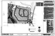
Cover Sheet<br />
#<br />
Applicant Cover Sheet Checklist Items Staff<br />
Not<br />
Use<br />
Applicable<br />
Requirement Additional Information Reference<br />
Applicable<br />
1 Index <strong>of</strong> titled drawing sheets All uploaded sheets are to be titled in<br />
a descriptive manner (i.e. Site Layout<br />
Plan, Landscape Plan, etc.).<br />
2 Vicinity Map Map showing location <strong>of</strong> property<br />
and adjacent streets within a<br />
maximum <strong>of</strong> a ½ mile radius.<br />
3 Show any public recreation<br />
requirement.<br />
For developments <strong>of</strong> 35 units or<br />
more: land dedication is required;<br />
general location must be clearly<br />
shown on the Parks, Recreation,<br />
Greenways, and Open Space Master<br />
Plan ; must be designated for either a<br />
public greenway or public park land.<br />
Developments under 35 units are<br />
required to pay a fee-in-lieu based on<br />
the density <strong>of</strong> the project.<br />
UDO Sec. 7.3<br />
Parks,<br />
Recreation,<br />
Greenways &<br />
Open Space<br />
Master Plan<br />
4 List & label UDO Supplemental<br />
UDO Sec. 4.4 <br />
Standards.<br />
5 List & label any variance conditions. <br />
6 Show any public recreation<br />
requirement.<br />
<br />
7 Project Data (tabular format)-requirements below:<br />
For developments <strong>of</strong> 51 multi-family<br />
residential units or more, land<br />
dedication is required and whose<br />
general locations are clearly shown<br />
on the Parks, Recreation, Greenways,<br />
and Open Space Master Plan and<br />
must be designated for either a public<br />
greenway or public park land.<br />
a Name, address(s) and parcel ID(s) <strong>of</strong><br />
the project<br />
Include any phase numbers.<br />
b Preparer’s name, address, phone<br />
number, fax number, and e-mail<br />
address<br />
c Owner’s name, address, phone<br />
number, fax number, and e-mail<br />
address<br />
d Contract purchaser’s name, address,<br />
phone number, fax number, and e-<br />
mail address<br />
e Annexation number(s) for property If property is not annexed and water<br />
and/or sewer is requested, an<br />
annexation petition must be<br />
submitted.<br />
f Zoning <strong>of</strong> the property; if conditional Contact the Planning Department at<br />
use or conditional zoning, list all 249-3426 to get a copy <strong>of</strong> the zoning<br />
rezoning conditions<br />
conditions.<br />
UDO Sec. 7.3<br />
Parks,<br />
Recreation,<br />
Greenways &<br />
Open Space<br />
Master Plan<br />
Annexation<br />
Petition<br />
Zoning Map<br />
<br />
<br />
<br />
<br />
<br />
<br />
<br />
<br />
<br />
Non-Residential Master Subdivision Plan Application – Last updated Feb 2014
#<br />
Applicant Cover Sheet Checklist Items Staff<br />
Not<br />
Use<br />
Applicable<br />
Requirement Additional Information Reference<br />
Applicable<br />
g Current 2030 Land Use Map<br />
designation<br />
h Proposed 2030 Land Use Map<br />
designation<br />
If amendment is requested or<br />
required application must be<br />
submitted.<br />
2030 LUM <br />
Application<br />
k Area <strong>of</strong> tract(s) In square feet or acres <br />
l Required front, side and rear yard<br />
UDO Sec. 5.1 <br />
setbacks<br />
m Amount and percentage <strong>of</strong> built upon<br />
UDO Sec. 5.1 <br />
area allowed<br />
UDO Sec. 6.1<br />
n Amount and percentage <strong>of</strong> built upon<br />
UDO Sec. 5.1 <br />
area proposed<br />
UDO Sec. 6.1<br />
o Indicate if the site is in the Primary or Watershed Protection Overlay District UDO Sec. 6.1 <br />
Secondary Watershed Protection<br />
Overlay District<br />
Map<br />
UDO Sec. 8.1.2<br />
(B)(2)(i)<br />
p Indicate if the site contains a FEMA<br />
designated 100 year floodplain<br />
q Gross square footage and percent <strong>of</strong><br />
RCA required<br />
r Gross square footage and percent <strong>of</strong><br />
RCA provided<br />
s Indicate if the site contains a historic<br />
structure<br />
Existing Conditions Check List<br />
#<br />
Floodplain Map UDO Sec. 6.2 <br />
UDO Sec. 8.1<br />
UDO Sec. 8.1<br />
UDO 12.2-<br />
Historic<br />
Structure<br />
Applicant Existing Conditions Sheet Checklist Items Staff<br />
Not<br />
Use<br />
Applicable<br />
Requirement Additional Information Reference<br />
Applicable<br />
1 Provide boundaries <strong>of</strong> the site in<br />
metes and bounds<br />
2 Provide aerial photo-based<br />
topography <strong>of</strong> the site at 2’ or 5’<br />
contours<br />
3 Call out location <strong>of</strong> slopes equal to or<br />
greater than 3:1 and rock<br />
outcroppings<br />
4 Provide tree survey locating all<br />
specimen (hardwood) trees at 18”<br />
caliper and larger within RCA and<br />
buffers on site<br />
5 Document that all proposed RCA<br />
areas meet the Criteria for<br />
Establishing RCA by means <strong>of</strong> a tree<br />
survey or other appropriate means<br />
UDO Sec. 8.1.2<br />
(B)(2)(a)<br />
Show existing grades. UDO Sec. 8.1.2<br />
(B)(2)(b)<br />
Other appropriate means include, but<br />
are not limited to, a registered<br />
forester’s or certified arborist’s report<br />
referenced to-scale digital photos or<br />
aerial photographs. Aerial<br />
photographs are not an acceptable<br />
UDO Sec. 8.1.2<br />
(B)(2)(c)<br />
UDO Sec. 8.1.2<br />
(B)(2)(d)<br />
UDO Sec. 8.1.2<br />
(B)(2)(e)<br />
<br />
<br />
<br />
<br />
<br />
<br />
<br />
<br />
<br />
Non-Residential Master Subdivision Plan Application – Last updated Feb 2014
#<br />
Applicant Existing Conditions Sheet Checklist Items Staff<br />
Not<br />
Use<br />
Applicable<br />
Requirement Additional Information Reference<br />
stand-alone means <strong>of</strong> documentation<br />
Applicable<br />
6 Document that existing buffers meet<br />
the required “A”, “B”, “C”, “D”, or “E”<br />
type standards by means <strong>of</strong> a tree<br />
survey or other appropriate means<br />
7 Show location <strong>of</strong> wetlands as<br />
determined by a licensed soil<br />
scientist, the Army Corps <strong>of</strong><br />
Engineers, or the NCDENR DWQ<br />
8 Show location <strong>of</strong> all creeks, streams,<br />
ponds, and dams<br />
9 Indicate whether the site is in the<br />
Primary or Secondary Watershed<br />
Protection Overlay District<br />
10 Show required riparian buffers on<br />
both sides <strong>of</strong> perennial and<br />
intermittent streams, including the<br />
location <strong>of</strong> the top <strong>of</strong> bank on both<br />
sides <strong>of</strong> the stream<br />
11 Show location <strong>of</strong> the 100 year<br />
floodplain and 100 year floodway<br />
based upon the FIRM maps, the FEMA<br />
detailed study, and field<br />
measurements<br />
for trees in RCA.<br />
Other appropriate means include, but<br />
are not limited to, a registered<br />
forester’s or certified arborist’s report<br />
referenced to-scale digital photos or<br />
aerial photographs. Aerial<br />
photographs are not an acceptable<br />
stand-alone means <strong>of</strong> documentation<br />
for trees in RCA.<br />
Watershed Protection Overlay District<br />
Map<br />
Riparian buffers on perennial streams<br />
are measured 100’ from the top <strong>of</strong><br />
the bank on both sides <strong>of</strong> the stream.<br />
Riparian buffers on intermittent<br />
streams are measured 50’ from the<br />
top <strong>of</strong> bank on both sides <strong>of</strong> the<br />
stream.<br />
If not applicable, certify that there is<br />
no FEMA floodplain on the subject<br />
property by giving FIRM map number<br />
and date. Provide non-FEMA flood<br />
study information on floodplains,<br />
floodways, flood fringes, and flood<br />
hazards at the construction plan stage<br />
<strong>of</strong> plan review.<br />
UDO Sec. 8.1.2<br />
(B)(2)(f)<br />
UDO Sec. 6.1<br />
UDO Sec. 8.1.2<br />
(B)(2)(g)<br />
UDO Sec. 8.1.2<br />
(B)(2)(h)<br />
UDO Sec. 8.1.2<br />
(B)(2)(i)<br />
UDO Sec. 6.1<br />
UDO Sec.<br />
6.1.11<br />
UDO Sec. 8.1.2<br />
(B)(2)(i)<br />
UDO Sec. 6.2<br />
UDO Sec. 8.1.2<br />
(B)(2)(j)<br />
<br />
<br />
<br />
<br />
<br />
<br />
12 Provide location <strong>of</strong> existing fencing,<br />
roads, and structures<br />
13 Provide locations <strong>of</strong> significant site<br />
elements<br />
14 Indicate clearly on the plans the<br />
location <strong>of</strong> all existing utilities (water,<br />
sewer, natural gas, electric,<br />
telephone, cable, fiber optic, etc.)<br />
above and/or below ground as well as<br />
existing utility easements<br />
Significant site elements include, but<br />
are not limited to, historic and<br />
cultural sites and structures, scenic<br />
views, rock outcroppings, and<br />
cemeteries.<br />
Accurately survey existing utilities;<br />
approximate locations will not be<br />
accepted. Include size and material.<br />
UDO Sec. 8.1.2<br />
(B)(2)(k)<br />
UDO Section<br />
8.1.2 (B)(2)(l)<br />
UDO Sec. 8.1.2<br />
(B)(2)(m)<br />
<br />
<br />
<br />
Non-Residential Master Subdivision Plan Application – Last updated Feb 2014
#<br />
Applicant Existing Conditions Sheet Checklist Items Staff<br />
Not<br />
Use<br />
Applicable<br />
Requirement Additional Information Reference<br />
Applicable<br />
15 Identify location <strong>of</strong> any underground<br />
storage tanks, hazardous waste and<br />
debris, abandoned wells, septic tanks<br />
or similar structures<br />
Subdivision Layout Sheet<br />
UDO Sec. 8.1.2<br />
(B)(2)(n)<br />
Applicant Subdivision Layout Sheet Checklist Items Staff<br />
#<br />
Not<br />
Applicable<br />
Applicable<br />
Requirement Additional Information Reference<br />
Use<br />
1 Base Items:<br />
a North Arrow <br />
b Roads and driveways List names <strong>of</strong> proposed roads. Road<br />
names must be pre-approved by<br />
Wake County GIS Department.<br />
<br />
c Vehicular Use Areas <br />
d Buildings <br />
e Detention, retention or natural ponds <br />
f Creeks, streams, ponds and dams <br />
g Location and dimension <strong>of</strong> all<br />
resource conservation area (RCA) and<br />
buffers including riparian buffers<br />
RCA must be recorded as a separate<br />
lot from the residential building lots.<br />
Include a metes and bounds<br />
description <strong>of</strong> the RCA required on<br />
final plat.<br />
UDO Sec.<br />
6.1.11<br />
UDO Sec.<br />
8.1.2(B)(1)<br />
UDO Sec. 8.2.6<br />
h All Public and Private Easements <br />
i Fences and decorative or retaining<br />
<br />
walls<br />
j Location <strong>of</strong> the 100 year floodplain<br />
and 100 year floodway based upon<br />
the FIRM maps, the FEMA detailed<br />
study and field measurements<br />
<br />
k Location <strong>of</strong> proposed street trees One per lot, two on a corner planted<br />
inside property lines<br />
2 Residential building lots must be<br />
located outside buffers, RCA and<br />
floodplain areas<br />
3 Square footage & dimensions <strong>of</strong> each<br />
lot<br />
4 Zoning, ownership and current use <strong>of</strong><br />
all adjacent tracts<br />
5 Boundary <strong>of</strong> entire tract by metes and<br />
bounds<br />
6 Location and dimensions <strong>of</strong> existing<br />
and proposed driveways or curb cuts<br />
on site and adjoining properties<br />
List uses such as residential, vacant,<br />
etc. Include uses on opposite side <strong>of</strong><br />
adjoining streets<br />
Include properties on opposite side <strong>of</strong><br />
adjoining streets and<br />
existing/proposed lane striping on all<br />
streets.<br />
<br />
<br />
<br />
<br />
<br />
<br />
<br />
<br />
Non-Residential Master Subdivision Plan Application – Last updated Feb 2014
#<br />
Applicant Subdivision Layout Sheet Checklist Items Staff<br />
Not<br />
Use<br />
Applicable<br />
Requirement Additional Information Reference<br />
Applicable<br />
7 Location <strong>of</strong> entrances/exits and<br />
general internal circulation<br />
8 Location <strong>of</strong> existing and proposed<br />
sidewalks and other pedestrian areas<br />
such as trails and greenways<br />
9 Ensure that a turning radius will<br />
accommodate emergency vehicles or<br />
anticipated delivery vehicles<br />
10 Streets and right-<strong>of</strong>-ways showing<br />
existing and proposed dimensions in<br />
accordance with the <strong>Town</strong>’s<br />
Transportation Plan and Spec Book<br />
Include lane striping, crosswalks,<br />
pavement markings and signs.<br />
Show widths <strong>of</strong> all features.<br />
Connections must be made to existing<br />
stubouts on adjacent property.<br />
Indicate location and dimensions <strong>of</strong><br />
pavement, curbs and gutters, and<br />
sidewalks. Where development abuts<br />
or includes a State maintained road,<br />
design must be submitted and<br />
reviewed concurrently with NCDOT.<br />
MUTCD<br />
NCDOT Specs<br />
Thoroughfare<br />
Plan Map<br />
TOA Details<br />
Sec. 300<br />
11 Show sight triangles with dimensions Sight triangles are typically 10’x70’. TOA Spec <br />
302F<br />
12 List proposed speed limit for each No streets can be proposed less than<br />
<br />
public street<br />
25 mph.<br />
13 Location <strong>of</strong> emergency access <br />
14 Location and dimensions <strong>of</strong> setbacks On corner lots, where the dwelling<br />
can face either street, provide<br />
building setback lines for each<br />
possible configuration. If the front <strong>of</strong><br />
the dwelling is limited to face only<br />
one street, then provide the<br />
appropriate building setback lines and<br />
add the words “FRONT ONLY” to<br />
indicate the front yard.<br />
15 Location and dimensions <strong>of</strong> parks,<br />
recreation areas and greenways or<br />
proposal for fee in lieu<br />
Any development <strong>of</strong> 35 units or more<br />
must show land dedication. The<br />
Parks, Recreation, and Cultural<br />
Resources Board will make a<br />
recommendation for dedication or<br />
fee in lieu – <strong>Town</strong> Council has the<br />
final say on which applies.<br />
16 Location <strong>of</strong> mail kiosk For subdivisions with multi-family<br />
units.<br />
17 Check the subdivision for conformity Thoroughfare Plan Map<br />
with the transportation plan, land use Land Use Plan<br />
plan, parks and recreation master P & R Master Plan<br />
plan, water & wastewater master Bike/Ped Plan<br />
plans and any other <strong>of</strong> the <strong>Town</strong>’s Water & Wastewater Master Plan<br />
adopted plans and policies<br />
23 Required Page Notes: 1-11 See the Required Notes Page <br />
<br />
<br />
<br />
<br />
<br />
<br />
<br />
<br />
Non-Residential Master Subdivision Plan Application – Last updated Feb 2014
Staging & Demolition Plan<br />
#<br />
Applicant Staging & Demolition Plan Checklist Items Staff<br />
Not<br />
Use<br />
Applicable Requirement Additional Information<br />
Reference<br />
Applicable<br />
1 Identify which existing trees will be<br />
saved and which will be removed.<br />
Show caliper & species <strong>of</strong> tree.<br />
<br />
2 Location <strong>of</strong> tree protection fencing. Fencing must be 1 foot away from the<br />
tree trunk for every 1 inch caliper <strong>of</strong><br />
the tree.<br />
3 Location and type <strong>of</strong> additional<br />
protective measures.<br />
4 Show proposed staging areas or<br />
dirt/material/equipment storage<br />
areas.<br />
5 If buildings will be demolished,<br />
include the following note: “A copy<br />
<strong>of</strong> the Demolition Notification from<br />
the NC Health Hazard Control Unit<br />
and an asbestos inspection report<br />
from a NC accredited asbestos<br />
inspector must accompany the<br />
application for the demolition permit<br />
which must be obtained prior to start<br />
<strong>of</strong> the demolition.”<br />
See Section 8.1.2(G)(1) <strong>of</strong> the UDO for<br />
additional protective fencing<br />
requirements for other site features.<br />
UDO Sec.<br />
8.1.2(G)(1)<br />
UDO Sec.<br />
8.1.2(G)(1)<br />
Demolition<br />
Application<br />
6 Location <strong>of</strong> construction entrance. TOA Spec<br />
400.06<br />
7 Show road or sidewalk barricades TOA Spec<br />
300.15<br />
<br />
<br />
<br />
<br />
<br />
<br />
Grading Plan<br />
Applicant Grading Plan Checklist Items Staff<br />
#<br />
Not<br />
Use<br />
Applicable<br />
Applicable<br />
Requirement Additional Information Reference<br />
1 <br />
Base Items See the Subdivision Layout<br />
Sheet<br />
Pg.5<br />
<br />
Non-Residential Master Subdivision Plan Application – Last updated Feb 2014
#<br />
Applicant Grading Plan Checklist Items Staff<br />
Not<br />
Use<br />
Applicable<br />
Requirement Additional Information Reference<br />
Applicable<br />
2 Provide FFE for all structures <br />
3 Provide a Final Rough Grading sheet<br />
<br />
that shows drainage <strong>of</strong> lots.<br />
4 Provide aerial photo-based<br />
<br />
topography <strong>of</strong> the subdivision at 2’ or<br />
5’ contours (as available), showing<br />
existing grades<br />
5 If there will be fill within a floodplain,<br />
a Letter <strong>of</strong> Map Revision based on Fill<br />
LOMR-F is required to be obtained<br />
Flood Plain Development Permit<br />
Application<br />
<br />
6 Indicate all slopes equal to or greater<br />
than 3:1 and show required<br />
stabilization measures<br />
7 Location and type <strong>of</strong> soil and erosion<br />
control measures<br />
8 Indicate if site is in the Primary or<br />
Secondary Watershed Protection<br />
Overlay District<br />
9 Location <strong>of</strong> existing trees to be saved<br />
and removed<br />
10 Provision for the adequate disposition<br />
<strong>of</strong> storm water in accordance with<br />
<strong>Town</strong> standards indicating location,<br />
sizes, types and grades <strong>of</strong> ditches,<br />
catch basins, and pipes with<br />
connections to existing drainage<br />
system(s).<br />
Slopes greater than 2:1 shall not be<br />
permitted.<br />
For sites where disturbed area is<br />
20,000sf or greater in size, follow the<br />
TOA S&E Construction Sequence.<br />
Watershed Protection Overlay District<br />
Map<br />
Show type and caliper <strong>of</strong> trees.<br />
Post-development run<strong>of</strong>f rate must<br />
not exceed pre-development run<strong>of</strong>f<br />
rate for the 1-yr, 24-hr, 10 yr and 24-hr<br />
storms. Lot lines should follow natural<br />
drainage ways. Natural drainage ways<br />
should be preserved in their natural<br />
state to the extent practicable.<br />
UDO Sec.<br />
8.1.4<br />
S&E<br />
Construction<br />
Sequence<br />
UDO Sec. 6.1<br />
UDO Sec.<br />
6.1.11<br />
<br />
<br />
<br />
<br />
<br />
11 Location <strong>of</strong> protection fencing UDO Sec.<br />
8.1.2(G)(1)<br />
DDM<br />
12 Location <strong>of</strong> retaining walls. Indicate<br />
material, color, height <strong>of</strong> wall and<br />
area <strong>of</strong> disturbance. Non-decorative<br />
walls are required to have facing (i.e.<br />
stucco). Top <strong>of</strong> wall and bottom <strong>of</strong><br />
wall spot elevations must be<br />
provided.<br />
Engineered drawings are required for<br />
walls <strong>of</strong> 5 feet or taller at the<br />
Construction Plan stage. The drawings<br />
must be designed, inspected and<br />
certified by a licensed pr<strong>of</strong>essional<br />
engineer.<br />
<br />
<br />
13 No site development activity including<br />
but not limited to testing, clearing,<br />
installation <strong>of</strong> S&E measures, or<br />
grading, shall occur until required<br />
protection fencing has been installed<br />
and inspected.<br />
A protection fencing installation<br />
permit may be obtained at the<br />
Planning Department or online.<br />
Tree Protection Fencing Application<br />
S&E<br />
Construction<br />
Sequence<br />
<br />
14 Protection fencing must be placed Additional protection fencing may be UDO Sec. <br />
Non-Residential Master Subdivision Plan Application – Last updated Feb 2014
#<br />
Applicant Grading Plan Checklist Items Staff<br />
Not<br />
Use<br />
Applicable<br />
Requirement Additional Information Reference<br />
Applicable<br />
away from any saved tree 1’ for each<br />
1” <strong>of</strong> tree caliper. Protection fencing<br />
must be placed at least 10’ away from<br />
any other designated RCA, along the<br />
outside line <strong>of</strong> the 100 year flood<br />
plain, and the outside edge <strong>of</strong> any<br />
riparian buffer.<br />
required in other locations close to<br />
construction activity where it is<br />
deemed necessary by the zoning<br />
enforcement <strong>of</strong>ficer; such areas may<br />
include but are not limited to common<br />
property lines or near public areas<br />
(sidewalks, etc.).<br />
8.1.2(G)(1)<br />
15 All grading and support structures<br />
associated with any retaining<br />
structure shall not encroach into any<br />
required buffer or protected area<br />
shall be contained entirely on site.<br />
16 Site elements required to satisfy<br />
recreational requirements must meet<br />
any applicable standards found in the<br />
TOA Standard Specifications and<br />
Standard Details and the<br />
requirements <strong>of</strong> the TOA Parks and<br />
Recreation Department<br />
17 Retaining systems providing<br />
cumulative vertical relief greater than<br />
5’ in height within a horizontal<br />
distance <strong>of</strong> 50’ or less, including<br />
retaining walls or mechanically<br />
stabilized earth walls shall be<br />
designed and constructed under the<br />
responsible charge <strong>of</strong> a registered<br />
pr<strong>of</strong>essional engineer and comply in<br />
all aspects <strong>of</strong> the NC Building Code,<br />
Section 1610.<br />
18 Indicate location, size and materials<br />
used for stormwater (drainage) lines.<br />
19 Indicate location and width dimension<br />
<strong>of</strong> easements required for<br />
stormwater (drainage) lines and<br />
culverts. Include permanent and<br />
temporary construction easements.<br />
Protected areas are defined as but are<br />
not limited to, RCA and critical root<br />
zones <strong>of</strong> trees, public utility easements<br />
and right-<strong>of</strong>-ways.<br />
Site elements include but are not<br />
limited to play fields and greenway<br />
trails.<br />
Retaining systems meeting these<br />
criteria will require a separate building<br />
permit prior to the start <strong>of</strong> work.<br />
TOA Spec<br />
Book<br />
20 Required Page Notes: 11-13 See the Required Notes Page <br />
<br />
<br />
<br />
<br />
<br />
Utility Plan<br />
#<br />
Applicant Utility Plan Checklist Items Staff<br />
Not<br />
Use<br />
Applicable<br />
Requirement Additional Information Reference<br />
Applicable<br />
Non-Residential Master Subdivision Plan Application – Last updated Feb 2014
Applicant Utility Plan Checklist Items Staff<br />
#<br />
Not<br />
Applicable<br />
Applicable<br />
Requirement Additional Information Reference<br />
Use<br />
1 Base Items See the Subdivision Layout<br />
Sheet<br />
Pg.5 <br />
2 Indicate whether or not requesting<br />
full town services – water, sewer and<br />
electricity.<br />
If electric utilities are provided by the<br />
<strong>Town</strong> <strong>of</strong> <strong>Apex</strong>, a consultation with the<br />
Electric Utilities Division (249-3427) is<br />
required.<br />
3 Give estimated loads and voltages. <br />
<br />
4 Indicate location and width dimension<br />
<strong>of</strong> easements required for utilities.<br />
Include permanent and temporary<br />
construction easements.<br />
<br />
5 Indicate clearly on the plans the<br />
location <strong>of</strong> all existing and proposed<br />
utilities above and/or below ground.<br />
Co-location <strong>of</strong> dry utilities is<br />
preferred.<br />
6 Slopes shall not be greater than 3:1<br />
where underground electric utility<br />
lines are proposed.<br />
Utilities include water, sewer, natural<br />
gas, electric, telephone, cable, fiber<br />
optic, etc. If the site is encumbered by<br />
existing utility easements then the<br />
applicant should provide a letter from<br />
the utility company indicating the<br />
acceptability <strong>of</strong> the site improvements.<br />
<br />
<br />
7 Show proposed locations <strong>of</strong> service<br />
corridors, transformers and meters<br />
and ensure that all point <strong>of</strong> delivery<br />
issues are coordinated with the TOA<br />
Electrical Utility Division or Progress<br />
Energy.<br />
8 Transformers must be located 10’ <strong>of</strong>f<br />
the building where there are openings<br />
(doors, windows, etc.) and 3’ <strong>of</strong>f <strong>of</strong><br />
solid masonry. The grade to the<br />
transformer must slope away from<br />
the building.<br />
9 Transformers shall not be located<br />
within required landscaped areas or<br />
islands unless additional space has<br />
been allocated for this purpose.<br />
10 Indicate location, size and materials<br />
used for water sanitary sewer lines<br />
and force main lines. Show water<br />
meter and clean out connections<br />
from building(s) to public lines.<br />
Note that for any electric service<br />
routes you must provide an easement<br />
clear <strong>of</strong> buildings, pavement,<br />
landscaped areas, and similar<br />
protected areas.<br />
A minimum <strong>of</strong> 10’ in front and 3’ on<br />
sides and back <strong>of</strong> transformer is<br />
needed for installation and<br />
maintenance.<br />
For well or septic system, appropriate<br />
permits from Wake County are<br />
required before building permit can be<br />
issued.<br />
TOA Spec<br />
209B<br />
TOA Spec<br />
209<br />
TOA Spec.<br />
100<br />
<br />
<br />
<br />
<br />
Non-Residential Master Subdivision Plan Application – Last updated Feb 2014
#<br />
Applicant Utility Plan Checklist Items Staff<br />
Not<br />
Applicable<br />
Requirement Additional Information Reference<br />
Use<br />
Include size and material <strong>of</strong><br />
appurtenances. If well or septic<br />
system, indicate proposed location.<br />
Applicable<br />
11 Indicate locations <strong>of</strong> utility poles, fire<br />
hydrants, transformers, light poles,<br />
light fixtures, etc.<br />
12 If a pump station (lift station) is<br />
proposed, show layout <strong>of</strong> the station<br />
according to the <strong>Town</strong> Standard<br />
Specification and Standard Details<br />
manual.<br />
TOA Spec<br />
Book<br />
<br />
<br />
13 Provide utility identifiers (naming<br />
conventions) for all proposed water,<br />
sewer and stormwater structures,<br />
lines and appurtenances.<br />
14 Location <strong>of</strong> fire lane striping and<br />
signage. Use 2” <strong>of</strong> SF 9.5A pavement<br />
and 8” <strong>of</strong> ABC stone properly layered<br />
and compacted anywhere a fire lane<br />
is required.<br />
15 If a sprinkler system is required, show<br />
layout <strong>of</strong> system to the building, the<br />
location <strong>of</strong> the FDC (Fire Department<br />
Connection), and the location <strong>of</strong> the<br />
backflow assembly.<br />
16 Location <strong>of</strong> existing trees to be saved<br />
and removed.<br />
TOA Spec<br />
300.24<br />
17 Location <strong>of</strong> trees to be planted. <br />
18 Location <strong>of</strong> protection fencing. UDO Sec.<br />
8.1.2(G)(1)<br />
DDM<br />
<br />
19 Location <strong>of</strong> recreational elements<br />
such as greenways in utility<br />
easements.<br />
20 Required Notes: 1,2, 4, 5, 14-<br />
22<br />
Landscape Plan<br />
See the Required Notes Page<br />
Applicant Landscape Plan Checklist Items Staff<br />
#<br />
Not<br />
Applicable<br />
Applicable<br />
Requirement Additional Information Reference<br />
Use<br />
1 <br />
Base Items See the Subdivision Layout<br />
Sheet<br />
Pg. 5<br />
<br />
2 Graphic symbols used to depict trees <br />
<br />
<br />
<br />
<br />
<br />
<br />
Non-Residential Master Subdivision Plan Application – Last updated Feb 2014
#<br />
Applicant Landscape Plan Checklist Items Staff<br />
Not<br />
Applicable<br />
Requirement Additional Information Reference<br />
Use<br />
and shrubs must accurately reflect<br />
the average mature spread<br />
Applicable<br />
3 Indicate location, width and type <strong>of</strong><br />
required buffers<br />
Existing plants to be saved and new<br />
plant material must be located and<br />
identified within the buffer.<br />
UDO Sec. 8.1<br />
UDO Sec. 8.2<br />
<br />
4 Indicate all slopes equal to or greater<br />
than 3:1 and provide appropriate<br />
landscaping and/or slope retention<br />
devices (no turf grasses) required to<br />
stabilize these areas<br />
See the DDM, page 26, Planting in<br />
Special Situations for more<br />
information. Slopes greater than 2:1<br />
are not permitted.<br />
DDM<br />
UDO Sec.<br />
8.1.4<br />
<br />
5 Number <strong>of</strong> plants along street based<br />
on total square footage <strong>of</strong> the<br />
streetscape buffer<br />
<br />
6 Show sight triangles with dimensions Sight triangles are typically 10’x70’. TOA Spec<br />
302F<br />
7 Type <strong>of</strong> trees, located near overhead If plant material encroaches into the UDO Sec.<br />
or underground utility lines<br />
easement, express written consent <strong>of</strong> 8.2.2(C)(2)<br />
the utility company is required. TOA<br />
does not allow plant material within its<br />
easements.<br />
8 Show building landscaping 1 tree and 3 shrubs per 2,000sf <strong>of</strong> UDO Sec.<br />
building footprint.<br />
8.2.4(A)<br />
9 Planting details for new plant material<br />
DDM<br />
installation<br />
10 Permanent protection for plants near<br />
vehicular use areas<br />
11 Location and type <strong>of</strong> plant material in<br />
vehicular use areas with planting area<br />
dimensions indicated. Location and<br />
dimensions <strong>of</strong> landscape islands.<br />
Permanent protection consists <strong>of</strong><br />
curbs, wheel stops, walls or fences. No<br />
vehicle use area is to be located<br />
further than 40’ from the trunk <strong>of</strong> a<br />
large type tree.<br />
Note that landscape islands must be a<br />
minimum <strong>of</strong> 250sf for one small tree<br />
and 350sf for one large tree.<br />
12 Enclosures and/or vegetative<br />
screening <strong>of</strong> loading and service<br />
areas, dumpsters and recycling bins,<br />
HVAC, mechanical, and utility units.<br />
13 Show location <strong>of</strong> light poles Light poles must be 20’ away from the<br />
base <strong>of</strong> a large type tree and 10’ away<br />
from the base <strong>of</strong> a small type tree.<br />
14 Indicate screening for vehicular use<br />
area from <strong>of</strong>f-site view.<br />
Screening is to consist <strong>of</strong> evergreen<br />
shrubs that will reach a height <strong>of</strong> 42” in<br />
3 years.<br />
UDO Sec.<br />
8.2.5(C)(2)<br />
UDO Sec.<br />
8.2.8<br />
UDO Sec.<br />
8.6.4 (B)<br />
15 Location, height and type <strong>of</strong> fencing <br />
<br />
<br />
<br />
<br />
<br />
<br />
<br />
<br />
<br />
Non-Residential Master Subdivision Plan Application – Last updated Feb 2014
#<br />
Applicant Landscape Plan Checklist Items Staff<br />
Not<br />
Applicable<br />
Requirement Additional Information Reference<br />
Use<br />
and retaining walls. Show elevation<br />
and construction detail.<br />
Applicable<br />
16 Plant list summary table with the following information:<br />
a Key identifying proposed plant<br />
<br />
material using botanical and common<br />
names<br />
b Quantity <strong>of</strong> each plant material <br />
c Size, height, caliper, and spacing <strong>of</strong><br />
plant material<br />
<br />
17 Required Notes: 6a-6e, 23-28 See the Required Notes Page <br />
Details Sheet<br />
#<br />
Applicant Details Sheet Checklist Items Staff<br />
Not<br />
Use<br />
Applicable<br />
Requirement Additional Information Reference<br />
Applicable<br />
1 Detailed drawing <strong>of</strong> protection<br />
fencing<br />
2 Detailed drawing <strong>of</strong> retaining wall<br />
including handrails and/or guardrails<br />
3 Detailed drawing <strong>of</strong> subdivision<br />
features including benches, , fences,<br />
curb and gutter, wheel stops, etc.<br />
4 Detailed drawing <strong>of</strong> each type <strong>of</strong><br />
accessible curb cut or ramp utilized<br />
on the project and located on private<br />
property.<br />
5 Detailed drawing <strong>of</strong> accessible parking<br />
delineation which includes the<br />
minimum dimensions and maximum<br />
slopes.<br />
Include colors <strong>of</strong> all materials.<br />
Include colors and manufacturers<br />
where applicable.<br />
The detail must include the minimum<br />
width <strong>of</strong> the walking surface and the<br />
maximum slopes <strong>of</strong> each surface. The<br />
detail must conform to and reference<br />
the N.C. Accessibility Code.<br />
The detail must conform to and<br />
reference the N.C. Accessibility Code<br />
and must not include and ground<br />
painted symbol.<br />
DDM<br />
TOA Spec<br />
300.09<br />
TOA Spec<br />
Book<br />
6 Detailed drawing <strong>of</strong> accessible parking<br />
and signage conforming to and<br />
referencing the N.C. Accessibility<br />
Code<br />
7 Detailed drawing <strong>of</strong> bicycle parking TOA Spec<br />
8 Detailed drawing <strong>of</strong><br />
dumpster/recycling bin enclosure<br />
Dumpster enclosures must be at least<br />
8’ tall or the height <strong>of</strong> the dumpster,<br />
whichever is taller and be built <strong>of</strong><br />
masonry material with opaque gates.<br />
300.20<br />
DDM<br />
UDO Sec.<br />
8.2.8 (B)(1)<br />
<br />
<br />
<br />
<br />
<br />
<br />
<br />
<br />
Transportation Impact Analysis (TIA)<br />
Verify the proposed use(s) would generate at least 1000 daily or 100 peak hour trips.<br />
Non-Residential Master Subdivision Plan Application – Last updated Feb 2014
#<br />
Applicant Transportation Impact Analysis Checklist Items Staff<br />
Not<br />
Use<br />
Applicable<br />
Requirement Additional Information Reference<br />
Applicable<br />
1 Site Plan or at a minimum, a land use<br />
plan, indicating conceptual access<br />
points to the external roadway<br />
system.<br />
2 Vicinity map showing the location <strong>of</strong><br />
the property and adjacent streets<br />
within the approved study area.<br />
3 Peak-hour volumes from a recent<br />
count, no more than one year old, at<br />
the time <strong>of</strong> submittal unless<br />
otherwise approved by <strong>Town</strong> staff.<br />
4 Average daily and peak hour vehicular<br />
trips generated by the proposed<br />
development.<br />
5 Trip distribution allocation on all<br />
roads and intersections within the<br />
study area approved by the <strong>Town</strong>.<br />
6 Intersection geometry and traffic<br />
control devices.<br />
Contact Transportation Engineer for<br />
approval <strong>of</strong> study area.<br />
UDO Sec.<br />
13.19<br />
UDO Sec.<br />
13.19<br />
UDO Sec.<br />
13.19<br />
UDO Sec.<br />
13.19<br />
UDO Sec.<br />
13.19<br />
UDO Sec.<br />
13.19<br />
<br />
<br />
<br />
<br />
<br />
<br />
7 Capacity analyses for all anticipated<br />
conditions (existing, no-build and<br />
build) including phasing milestones<br />
unless otherwise approved by <strong>Town</strong><br />
staff.<br />
8 Documentation <strong>of</strong> data and<br />
assumptions.<br />
9 Proposed road improvements in<br />
accordance with the UDO<br />
requirements for a Traffic Impact<br />
Analysis (TIA).<br />
Site Analysis Report<br />
Required only upon request <strong>of</strong> the Planning Department<br />
UDO Sec.<br />
13.19<br />
UDO Sec.<br />
13.19<br />
UDO Sec.<br />
13.19<br />
<br />
<br />
<br />
#<br />
Applicant Site Analysis Report Checklist Items Staff<br />
Not<br />
Use<br />
Applicable<br />
Requirement Additional Information Reference<br />
Applicable<br />
1 Report by a certified arborist,<br />
forester, or horticulturist indicating<br />
the general health and condition <strong>of</strong><br />
site vegetation and/or specimen<br />
trees.<br />
2 Report by a design pr<strong>of</strong>essional<br />
(architectural, engineering, etc.)<br />
related to any other relevant existing<br />
site features (ponds/dams, wetlands,<br />
structures, etc.).<br />
Information to be included: type <strong>of</strong><br />
trees and vegetation, size range and<br />
average sizes, density, general health<br />
and conditions, special vegetation, and<br />
any noxious vegetation.<br />
Report should indicate the general<br />
condition <strong>of</strong> the feature.<br />
<br />
<br />
Non-Residential Master Subdivision Plan Application – Last updated Feb 2014
#<br />
Applicant Site Analysis Report Checklist Items Staff<br />
Not<br />
Use<br />
Applicable<br />
Requirement Additional Information Reference<br />
Applicable<br />
3 Proposal for protecting existing<br />
vegetation and site features such as<br />
structures, wetlands, floodplains,<br />
floodways, etc.<br />
4 Any reports requested by Planning<br />
staff to ensure site features do not<br />
pose a threat to the health, safety<br />
and welfare <strong>of</strong> the <strong>Town</strong>’s residents.<br />
5 Show decibel levels for generators,<br />
chillers, HVAC units, etc.<br />
Site plan must meet decibel levels as<br />
required by <strong>Town</strong> Code <strong>of</strong> Ordinances.<br />
Code <strong>of</strong><br />
Ordinances<br />
Ch. 14, Sec.<br />
14-30<br />
<br />
<br />
<br />
Required Plan Notes:<br />
1) No site development activity including but not limited to testing, clearing, installation <strong>of</strong> S&E measures, or<br />
grading, shall occur until required protection fencing has been installed and inspected. A protection<br />
fencing installation permit may be obtained at the Planning Department or by calling 919 249-3426.<br />
2) Protection fencing must be placed:<br />
a) Away from any saved tree one foot for each inch <strong>of</strong> tree caliper.<br />
b) At least 10 feet away from any other designated resource conservation area, such as but not limited to<br />
historic buildings and structures, wetlands, and ponds.<br />
c) Along the outside line <strong>of</strong> the 100-year floodplain, and the outside edge <strong>of</strong> any riparian buffer.<br />
3) Additional protection fencing may be required in other locations close to construction activity where it is<br />
deemed necessary by the zoning enforcement <strong>of</strong>ficer; such areas may include but are not limited to<br />
common property lines or near public areas (sidewalks, etc.).<br />
4) All grading and support structures associated with any retaining structure shall not encroach into any<br />
required buffer or protected area (such as but not limited to, RCA and critical root zones <strong>of</strong> trees, public<br />
utility easements and rights-<strong>of</strong>-way), and shall be contained entirely on site.<br />
5) Site elements required to satisfy recreational requirements such as but not limited to play fields and<br />
greenway trails must meet any applicable standards found in the <strong>Town</strong> <strong>of</strong> <strong>Apex</strong> Standard Specifications and<br />
Construction Details and the requirements <strong>of</strong> the <strong>Town</strong> <strong>of</strong> <strong>Apex</strong> Parks and Recreation Department.<br />
6) The screening <strong>of</strong> loading docks, roll-out containers, dumpsters, outdoor storage, mechanical and HVAC<br />
equipment, and similar facilities on the ro<strong>of</strong>, ground or building shall meet the requirement <strong>of</strong> Section 8.2.8<br />
<strong>of</strong> the UDO. Specifically screening must be done so that:<br />
a) It is incorporated into the overall design theme <strong>of</strong> the building and landscaping<br />
b) Screening materials are not different from or inferior to the principal materials <strong>of</strong> the building or<br />
landscape and are similar in material and color<br />
Non-Residential Master Subdivision Plan Application – Last updated Feb 2014
c) Screening items are out <strong>of</strong> view from adjacent properties and public streets, and a totally opaque<br />
screen is achieved<br />
d) Any ground-mounted HVAC or other mechanical or utility equipment six-feet tall or higher must be<br />
fenced and landscaped.<br />
e) Dumpster enclosures must be eight feet tall or the height <strong>of</strong> the dumpster whichever is greater and be<br />
built <strong>of</strong> masonry material with opaque gates. Where practicable, shrubs or other plants must be<br />
planted outside the enclosure to visually s<strong>of</strong>ten the appearance.<br />
7) All required site elements shown within a particular phase must be installed before a final certificate <strong>of</strong><br />
occupancy may be issued for any building within that phase.<br />
8) Prior to scheduling a final site inspection site items such as but not limited to, lighting, landscaping<br />
(including mulch), screening (i.e.: dumpsters/trash, mechanical/HVAC, etc.), site stabilization (seeding), and<br />
parking and pavement marking must be completed.<br />
9) Individual signs are not approved as part <strong>of</strong> site plan approval process. A separate sign permit must be<br />
obtained prior to installation <strong>of</strong> the sign. Multiple use lots, non-residential subdivisions, and multiple tenant<br />
lots must submit a Master Sign Plan for approval.<br />
10) Retaining systems providing a cumulative vertical relief greater than five feet in height within a horizontal<br />
distance <strong>of</strong> 50 feet or less, including retaining walls or mechanically stabilized earth walls shall be designed<br />
and constructed under the responsible charge <strong>of</strong> a registered pr<strong>of</strong>essional engineer and comply in all<br />
aspects with the NC Building Code section 1610. Retaining systems meeting these criteria will require a<br />
separate building permit prior to start <strong>of</strong> work.<br />
11) A Grading Permit, when applicable, can be issued by the Building Inspections Division only after approval <strong>of</strong><br />
tree protection fencing, S&E Measures in place and approved and a certificate <strong>of</strong> compliance has been<br />
issued by the Public Works Department.<br />
12) Retaining systems providing a cumulative vertical relief greater than five feet in height within a horizontal<br />
distance <strong>of</strong> 50 feet or less, including retaining walls or mechanically stabilized earth walls shall be designed<br />
and constructed under the responsible charge <strong>of</strong> a registered pr<strong>of</strong>essional engineer and comply in all<br />
aspects with the NC Building Code section 1610. Retaining systems meeting these criteria will require a<br />
separate building permit prior to start <strong>of</strong> work.<br />
13) Prior to approval <strong>of</strong> a final plat or issuance <strong>of</strong> a certificate <strong>of</strong> occupancy, any development where an<br />
engineered stormwater control structure is required, contact the Environmental Programs Manager at 249-<br />
3413 to demonstrate that the required structure is in place, that it is operational and that is complies with<br />
all relevant portions <strong>of</strong> UDO Section 6.1.12 Engineered Storm Water Controls. If the engineered stormwater<br />
control structure is used as part <strong>of</strong> a temporary erosion control measure, the inspection will occur during<br />
the appropriate phase <strong>of</strong> construction.<br />
14) All water & sewer lines shall be installed with a minimum <strong>of</strong> 3 feet <strong>of</strong> cover.<br />
15) Maintain 18” minimum vertical separation between utilities.<br />
16) Verify all illustrated utility crossings prior to construction and notify the engineer if conflicts are<br />
encountered.<br />
17) Contractor shall coordinate utility relocation or abandonment with local utility companies as required.<br />
18) Utilities will not encroach upon protected areas or run parallel through any required buffer.<br />
19) All metered connections to <strong>Town</strong> potable water shall have a <strong>Town</strong>-approved backflow prevention assembly<br />
installed.<br />
20) Water & sewer shall be at least 10 feet laterally from existing or proposed sewers. Where local conditions<br />
prevent a separation <strong>of</strong> 10 feet, the water main may be laid closer, provided that the elevation <strong>of</strong> the<br />
Non-Residential Master Subdivision Plan Application – Last updated Feb 2014
ottom <strong>of</strong> the water main is at least 18 inches above the top <strong>of</strong> the sewer with a horizontal separation <strong>of</strong> at<br />
least 3 feet.<br />
21) All new public water and sewer lines contained within a <strong>Town</strong> <strong>of</strong> <strong>Apex</strong> Public Utility Easement will require a<br />
Water Distribution Extension Permit and/or a Gravity Sewer Extension Permit prior to the release <strong>of</strong><br />
construction drawings. All Water Distribution Extension Permit Applications shall be accompanied by a<br />
Sealed Engineer’s Report per the <strong>Town</strong> <strong>of</strong> <strong>Apex</strong> Spec Book. Contact the Engineering Division at 249-3394 to<br />
obtain these permit applications.<br />
22) A plumbing permit issued by the Building Inspection Division is required for all plumbing systems, including<br />
storm drainage systems, installed outside the Public Right <strong>of</strong> Way or a Public Utility Easement. These<br />
systems shall be inspected and approved by the plumbing inspector prior to covering. Contact the Code<br />
Enforcement Supervisor at 249-3381 for information including the utilization <strong>of</strong> a third-party inspection<br />
agency.<br />
23) All landscaping is required to be installed prior to a certificate <strong>of</strong> occupancy for the project, or in the case <strong>of</strong><br />
phased development, for the phase <strong>of</strong> the project. If the applicant chooses to delay the installation <strong>of</strong><br />
landscaping from April 1 through September 1, then the applicant shall provide a cash bond equal to 150<br />
percent <strong>of</strong> the cost <strong>of</strong> materials and installation, based on the highest estimate received, to ensure<br />
installation <strong>of</strong> the required landscaping.<br />
24) Required buffers must meet the minimum opacity requirements for the particular buffer type as described<br />
in section 8.2.6 <strong>of</strong> the UDO.<br />
25) Any vegetation that is dead, substandard, unhealthy, <strong>of</strong> poor structural quality, or missing, shall be<br />
replaced in conformance with town standards.<br />
26) All plant material shall be allowed to reach their mature size and maintained at their mature size. Plants<br />
shall not be cut or severely pruned so that their natural form is impaired.<br />
27) All slopes greater than 3:1 but less than 2:1 shall be stabilized with permanent slope retention or a suitable<br />
combination <strong>of</strong> plantings and retention devices.<br />
28) Slopes equal to 3:1 shall be stabilized with permanent groundcover, not with turf grass.<br />
Non-Residential Master Subdivision Plan Application – Last updated Feb 2014