Download - FortWhyte Alive
Download - FortWhyte Alive
Download - FortWhyte Alive

Create successful ePaper yourself
Turn your PDF publications into a flip-book with our unique Google optimized e-Paper software.
Self-Guided Orienteering At <strong>FortWhyte</strong> <strong>Alive</strong><br />
Grade Level 4-S4<br />
2 Hours<br />
GOAL<br />
To learn about the sport of orienteering and the techniques used in the sport, and to have an<br />
outdoor physical recreation experience using <strong>FortWhyte</strong> <strong>Alive</strong>’s permanent orienteering course.<br />
OBJECTIVES<br />
The student should be able to:<br />
1. Use a map to find their location, and make plans to move from one place to another.<br />
2. Understand the symbols used on an orienteering map<br />
3. Gain an appreciation for the sport of orienteering.<br />
4. Using a map, run through an orienteering event on <strong>FortWhyte</strong>’s permament course<br />
VOCABULARY<br />
Orienteering, Control Station, Control Card, Course<br />
MATERIALS<br />
1. Orienteering maps<br />
2. Control and Score Cards; pencils (one for each group)<br />
3. Clipboards (one for each group)<br />
4. Control Stations (these are permenantly set up on the property, and maintained by the MB<br />
Orienteering Association)<br />
INTRODUCTION<br />
1. Game Set-up<br />
- The course is run using the south deck of the ARC as home base. The course,<br />
permanently installed, is laid out on the south part of <strong>FortWhyte</strong>’s property.<br />
- You will need to have orienteering maps (1 for every 4-5 students), the same number of<br />
score/control cards and pencils, a first aid kit, and a whistle<br />
2. Introduction<br />
- The Introductory Question for this program is “What is Orienteering?”. Have the<br />
students think about the questions as they break into groups of 4-6 people.<br />
- Discuss the Answers:<br />
- Orienteering is a sport, open to all ages.<br />
- It is very easy to do, but very difficult to do at the highest level of competition.
- Even at its lowest intensity, orienteering requires walking outdoors, thus it is<br />
cardiovascular exercise.<br />
- Orienteers: use a map, find their own way, and often use a compass. All other<br />
answers are options.<br />
- The goal of orienteering when competing is to find all the control stations, or<br />
marked points on the map, faster than other individuals or teams. The goal in a noncompetitive<br />
sense is to have fun outdoors, and to test one’s skills at navigating and<br />
movement.<br />
- Orienteering competitions can take place anywhere, from crowded cities to<br />
remote national parks.<br />
- The three pieces of equipment an orienteer needs are: shoes/outdoor clothes, a<br />
map, and a compass. For an event like <strong>FortWhyte</strong>, one does not even need a compass!<br />
- The skills an orienteer must possess are map reading, route planning, and a<br />
degree of physical fitness.<br />
3. Course Explanation<br />
The course at <strong>FortWhyte</strong> <strong>Alive</strong> consists of 17 control stations. Each stations<br />
consists of a number and a letter on a orange and white metal placard on a steel<br />
pole. On the map, the control stations are indicated by red circles; somewhere<br />
within the circle one will find the control station. Though none are hidden, most<br />
are not immediately obvious. The letters, put in order on the score card, spell a<br />
message.<br />
The orienteer’s job is to find as many (or all) of the control stations in the time<br />
allotted to them. Because this will be a first orienteering experience for many<br />
participants, competition (racing against each other) is discouraged. Teamwork<br />
within small groups, eg. Making route decisions together, is encouraged.<br />
Before letting any team start, be sure to cover the following safety rules:<br />
- water features such as ponds are off limits.<br />
- Though you will have to leave the trail, no running in the woods.<br />
- Ensure each team has a watch, so they know how much time they have<br />
left in the game.<br />
- Climbing any feature is not allowed.<br />
- Interfering with another team will result in a team’s disqualification,<br />
and possible further sanction from the participants’ school.<br />
- The staff person will be on the ARC deck, to answer questions and<br />
administer first aid if necessary.<br />
- Be sure to hand out score/control cards, and explain that at each<br />
station, the team must write down the letter shown at that station.<br />
All teams start from the back deck of the ARC. You can stagger the start by<br />
sending a few teams at a time, or by having the teams start at different control<br />
stations (for instance, Team A starts at station 1, Team B at station 17, etc.)<br />
The outdoor orienteering portion of this activity should take about an hour and<br />
fifteen minutes.<br />
2
After starting the teams, remain on the deck, ready to answer questions. Other teachers<br />
and supervisors should be encouraged to participate, either as team members with students, as<br />
individuals, or as a supervisor team.<br />
5. Wrap:<br />
The wrap for this activity is a debriefing discussion. Use the questions below as a<br />
guideline for how to wrap up.<br />
How did the groups do? How many were able to find all the control stations? 75% of the<br />
control stations? How many did each group find? What is the secret message spelled out by the<br />
letters of the control stations?<br />
Did the groups who were most successful work as teams? What was good about working<br />
as a team? Was it ever frustrating?<br />
How well was each team able to keep track of its location on the map?<br />
Discuss how this event differs from other orienteering (no compass work, distance/time).<br />
well.<br />
Thank and congratulate the group; thank the teachers and supervisors, and wish the group<br />
Background Information<br />
What is Orienteering?<br />
Orienteering involves using a detailed map and a compass to find a series of checkpoints on the<br />
ground. An orange and white marker (called a “control”) is located at each checkpoint. Either a<br />
card-punching device or an electronic timing unit is attached to each control so that competitors<br />
can prove they found it. At most events, the objective is to visit all of the controls, in the<br />
specified order, in the fastest time.<br />
Orienteering is a great sport because:<br />
It is easy to learn and requires no special equipment to get started.<br />
It can be enjoyed as a walk in the outdoors or as a competitive sport.<br />
Courses of varying length and difficulty are offered so that anyone can compete,<br />
regardless of age or experience. (This makes it a good sport for families.)<br />
For serious competitors, the sport is challenging both physically and mentally. Elite<br />
competitors have to run quickly while simultaneously navigating through complex<br />
terrain 1 .<br />
History of Orienteering:<br />
3
Orienteering began as a military exercise for Swedish officer candidates in the late 19 th century.<br />
In the 1930’s, affordable compasses became available, and the sport quickly caught on as a<br />
pastime in Sweden. Other European nations, such as Switzerland, Finland, the Soviet Union, and<br />
Hungary also developed orienteering clubs who pursued the acitivity as a sport.<br />
Following the Second World War, many other countries developed sport orienteering traditions.<br />
The United States, Canada, Japan, Australia, and New Zealand are now all active participants in<br />
the International Orienteering Federation.<br />
Orienteering is not currently an Olympic sport; however, it is an event at the World Games.<br />
Foot orienteering is the original form of the sport, and still the most popular, but other methods<br />
of transportation (such bicycles, canoes, etc.) have led to different forms of the sport.<br />
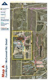
Fort Whyte Permanent Orienteering Course<br />
This facility has been developed by the Manitoba Orienteering Association, Inc., in cooperation<br />
with Fort Whyte. We hope that you will enjoy this activity and that you will join us for other<br />
Orienteering activities around the province.<br />
Notes<br />
Please be aware that you are running through a living area. Take care and do not damage plants,<br />
trees or shrubs in the park.<br />
You are also likely to encounter other individuals and groups while completing this course.<br />
Please do not disturb other users by running through their activities.<br />
Note that admission id required to Fort Whyte in order to use the course.<br />
How to use the course<br />
Before Starting:<br />
1) Print/pick up a copy of these instructions and a copy of the control card.<br />
2) Print/pick up a copy of the map. The map is a PDF file so you will need Adobe Reader to view<br />
and print. You can download the map from<br />
http://www.orienteering.mb.ca/PermanentCourses/<strong>FortWhyte</strong>.pdf (664KB). The map should be<br />
printed in color.<br />
3) Note the map scale - 1:5,000. This means that 1cm on the map = 5,000cm or 50m on the<br />
ground.<br />
4) The arrows on the meridian lines denote magnetic north. No adjustment for declination is<br />
required.<br />
5) Read the legend carefully.<br />
Start:<br />
The start is at the Alloway Center.The start is indicated by a triangle on the map.<br />
What to Do:<br />
1. Visit the controls marked on the map with numbered circles. At each location you will find a<br />
4
post with a red and white sign that has black letters and numbers.<br />
2. Each sign has its number marked on it, plus a letter. Print the letter on the card. Use the box<br />
with the same number as the control.<br />
3. You may take one or several occasions to visit all the controls.<br />
4. On your first visit to the course, begin at the start (triangle). On later visits you can start at any<br />
place on the map that you choose.<br />
5. Navigate to each control. Map reading will be your main means of doing this, while a compass<br />
will be very useful to orient the map (keeping north on the map pointing to north on the terrain).<br />
Achievement Certificate:<br />
When you have found all the controls and recorded the letter on the card, you can get an<br />
achievement certificate for completing the course. Put your name and address on the card and<br />
mail to the Manitoba Orienteering Association, 200 Main Street, Winnipeg, MB, R3C 4M2.<br />
Other ways to use the course:<br />
Once you have completed the course you can have more fun by trying the following activities:<br />
Score Orienteering - Set a time limit for yourself or your group. See how many points you can<br />
get before the time is up. Subtract one point for each minute you are over the allotted time. If you<br />
use the points listed with the control descriptions you should start from the triangle on the map.<br />
Make your own course - Pick a number of controls. Decide on what order to visit them. See<br />
who can finish the course in the fastest time.<br />
Control Descriptions<br />
Points (for Score<br />
No. Description<br />
Orienteering)<br />
1 Boulder 5<br />
2 South side of building 5<br />
3 Fence 10<br />
4 NW foot of hill 10<br />
5 East side of building 5<br />
6 Between boulders 20<br />
7 Between lakes 15<br />
8 North side of hill 10<br />
9 Train track junction 15<br />
10 Edge of clearing 20<br />
11 Boulder 25<br />
12 Building corner 25<br />
13 Path junction 25<br />
14 Boulder 20<br />
15 Path junction 20<br />
16 West end of deck 5<br />
17 Post 5<br />
(2)<br />
Tips and Tricks:<br />
- knowing where one is on the map may be more important than moving<br />
quickly.<br />
5
- Continual contact between one’s map and one’s surroundings are<br />
essential.<br />
- The large red arrow on the map points north. To keep the map<br />
“oriented”, and thus a true representation of the land, the map must be<br />
turned as the group moves.<br />
FOOTNOTES: Paragraphs 1 and 2 are taken from the Manitoba Orienteering Association<br />
website, http://www.orienteering.mb.ca/, accessed 2008-SEPT-08. Material used with<br />
permission.<br />
6