Discovering Accrington - Urbed
Discovering Accrington - Urbed
Discovering Accrington - Urbed

You also want an ePaper? Increase the reach of your titles
YUMPU automatically turns print PDFs into web optimized ePapers that Google loves.
<strong>Discovering</strong> <strong>Accrington</strong><br />
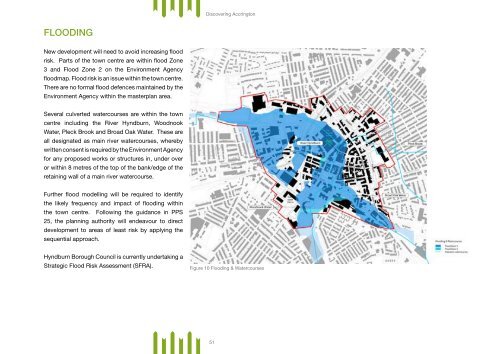
Flooding<br />
New development will need to avoid increasing flood<br />
risk. Parts of the town centre are within flood Zone<br />
3 and Flood Zone 2 on the Environment Agency<br />
floodmap. Flood risk is an issue within the town centre.<br />
There are no formal flood defences maintained by the<br />
Environment Agency within the masterplan area.<br />
Several culverted watercourses are within the town<br />
centre including the River Hyndburn, Woodnook<br />
Water, Pleck Brook and Broad Oak Water. These are<br />
all designated as main river watercourses, whereby<br />
written consent is required by the Environment Agency<br />
for any proposed works or structures in, under over<br />
or within 8 metres of the top of the bank/edge of the<br />
retaining wall of a main river watercourse.<br />
Further flood modelling will be required to identify<br />
the likely frequency and impact of flooding within<br />
the town centre. Following the guidance in PPS<br />
25, the planning authority will endeavour to direct<br />
development to areas of least risk by applying the<br />
sequential approach.<br />
Hyndburn Borough Council is currently undertaking a<br />
Strategic Flood Risk Assessment (SFRA).<br />
Figure 10 Flooding & Watercourses<br />
51