Reservoir Focus for Giant Offshore Duo - Hart's E&P
Reservoir Focus for Giant Offshore Duo - Hart's E&P
Reservoir Focus for Giant Offshore Duo - Hart's E&P

Create successful ePaper yourself
Turn your PDF publications into a flip-book with our unique Google optimized e-Paper software.
OFFICIAL SHOW DAILY PUBLISHER OF THE 75TH EAGE CONFERENCE AND EXHIBITION<br />
LONDON THURSDAY<br />
DAILYNEWS<br />
2013 EAGE Conference & Exhibition<br />
<strong>Reservoir</strong> <strong>Focus</strong> <strong>for</strong> <strong>Giant</strong> <strong>Offshore</strong> <strong>Duo</strong><br />
The benefits of imaging and characterization studies are clear on Kashagan and Lula.<br />
By Mark Thomas, Senior editor<br />
Two of the largest offshore fields ever discovered have been in the spotlight at EAGE<br />
2013, with the ongoing development of both critically influenced by the application<br />
of reservoir imaging and characterization technologies.<br />
The two giants concerned are very different animals. One is the huge Lula field<br />
(<strong>for</strong>merly called Tupi) in the presalt Santos basin, lying in ultra-deep water and with<br />
recoverable reserves estimated at around 8 Bbbl of sweet light oil.<br />
The other could not be more different: the even larger Kashagan light oil and sour<br />
gas presalt giant in the shallow waters of the northern Caspian Sea, one of the largest<br />
discoveries made in the last 30 years with recoverable reserves put at up to 13 Bboe out<br />
of estimated gross reserves of more than 35 Bboe.<br />
Kashagan is part of the North Caspian Sea production-sharing agreement operated<br />
by the North Caspian Operating Co., on behalf of a consortium consisting of KazMunayGas,<br />
Eni, Shell, ExxonMobil, Total, ConocoPhillips, and Inpex.<br />
Super-giant complex reservoir<br />
In an Eni presentation during a reservoir simulation session yesterday, the operator<br />
outlined work by the company and its partners since the field’s discovery in 2000 to investigate<br />
the reservoir characteristics <strong>for</strong> this super-giant and complex fractured carbonate<br />
reservoir offshore Kazakhstan.<br />
The field covers a surface area of approximately 75 km by 45 km (47 miles by 28<br />
miles) and sits in water depths of between 3 m and 9 m (10 ft and 30 ft), while the huge<br />
reservoir itself sits around 4,200 m (13,780 ft) below the seabed. Its challenging technical,<br />
logistical, and environmental nature means that it has taken some time <strong>for</strong> the operator<br />
and its partners to bring the first development phase of the field to fruition. However,<br />
Kashagan is expected to<br />
begin flowing first oil and<br />
gas later this year.<br />
The first experimental<br />
program phase will<br />
see around 180,000 b/d<br />
produced from the eastern<br />
part of the field, with the<br />
production figure only<br />
constrained by the gashandling<br />
capacity. The<br />
overall scheme will see<br />
production hubs located<br />
on six plat<strong>for</strong>ms and<br />
artificial island mounds<br />
(mainly to act as ice barriers),<br />
collecting production<br />
from satellite islands from<br />
where production wells<br />
are being drilled.<br />
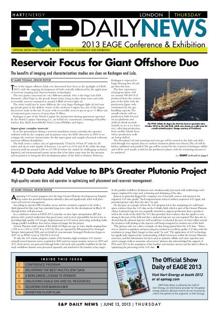
The FPSO Cidade de Angra dos Reis has been in operation since<br />
October 2010 on the Lula field, which was chosen as a pilot area <strong>for</strong><br />
a multi-azimuth project. (Image courtesy of Petrobras)<br />
The first phase’s oil and nonreinjected sour gas will be treated in the hubs and delivered<br />
through two separate lines to onshore treatment plants near Atyrau. The oil will be<br />
further stabilized and purified. The gas will be treated <strong>for</strong> the removal of hydrogen sulfide<br />
and will be used mostly as fuel <strong>for</strong> the production plants, with the remaining amount to<br />
be marketed.<br />
See GIANT continued on page 6<br />
4-D Data Add Value to BP’s Greater Plutonio Project<br />
High-quality seismic data aid operator in optimizing well placement and reservoir management.<br />
By Mark Thomas, Senior editor<br />
repeating 4-D seismic program over the large Greater Plutonio development in Angola’s<br />
A deep waters has provided important subsurface data and significantly aided well placement<br />
and reservoir management.<br />
According to operator BP, a baseline survey and two monitors acquired so far (with a<br />
third planned <strong>for</strong> this year) have provided long-term value <strong>for</strong> the development in Block 18<br />
through better well placement.<br />
In a conference session at EAGE 2013 yesterday on time-lapse interpretation, BP’s Joe<br />
Jackson told a packed auditorium that good source and receiver repeatability has been key to<br />
providing high-quality 4-D images. Improvements in 4-D seismic processing, including multivintage<br />
parallel workflows, have led to enhanced images <strong>for</strong> the project.<br />
Greater Plutonio itself consists of five fields of Oligocene age, in water depths ranging from<br />
1,200 m to 1,500 m (3,937 ft to 4,921 ft). They are operated by BP, partnered by Sonangol<br />
Sinopec International (SSI), and on behalf of concessionaire Sonangol. Production began in<br />
2007 via an FPSO vessel at 120,000 b/d of oil.<br />
To date the 4-D seismic program consists of the baseline, high-resolution 3-D narrowazimuth<br />
towed-streamer survey acquired in 2000 and two repeat monitor surveys in 2009 and<br />
2011. Each survey was processed through both a fast track and a parallel workflow. In the fast<br />
track workflows datasets were processed separately and matched to the baseline at key stages.<br />
In the parallel workflows all datasets were simultaneously processed with multivintage techniques<br />
employed <strong>for</strong> steps such as binning and destriping of the data.<br />
Jackson in particular flagged the company’s use of steerable sources and streamers <strong>for</strong><br />
improved 4-D data quality. “Such improvements reduced artifacts, improved 4-D signal, and<br />
provided greater value from the data,” he said.<br />
He also gave an example of how the 4-D program led to the retargeting of a well based<br />
upon evidence from the 4-D data on the Cobalto field, which is part of the Greater Plutonio<br />
cluster. A planned injector was originally intended to support production from a producer<br />
well in the north of the field. The 4-D data provided clear evidence that the aquifer is very<br />
strong in this part of the field and that a dedicated injector was not required. The data also indicated<br />
that the planned injector well would have accelerated the pace of water influx toward<br />
the producer well, leading to the injector well being retargeted to another area of the field.<br />
This, Jackson said, was a direct example of value being gained from the 4-D data. “Attention<br />
to detail in acquisition and processing has resulted in excellent-quality 4-D data, with the<br />
resolution to image fluid changes in thin sands,” he said. “The application of 4-D technology<br />
has significantly improved the understanding of fluid movement within the Greater Plutonio<br />
reservoirs, and this in<strong>for</strong>mation has been used to optimize offtake and water injection rates<br />
and to retarget wells to maximize oil recovery.” Jackson also acknowledged the support of<br />
PGS and CGG in the acquisition of the baseline and monitor surveys and the latter’s ef<strong>for</strong>ts in<br />
optimizing the processing of the 4-D data. n<br />
inside this issue<br />
2 Conference Program<br />
4 delivering the best multiclient data<br />
5 A WORLDWIDE LICENSE TO OPERATE<br />
12 unlocking shale gas and oil resources<br />
15 delivering your basin in a box<br />
16 EXHIBITION FLOOR PlAN<br />
991-994 covers-JUNE_Layout 1 5/20/13 11:06 AM Page 991<br />
JUNE 2013<br />
Sand and Proppant/<br />
Fluid Management<br />
Topsides Solutions<br />
Deepwater Rig<br />
Advances<br />
Land Seismic<br />
Improving<br />
Exploration<br />
Success<br />
REGIONAL<br />
REPORT:<br />
CHINA<br />
Effective completions<br />
extend well life<br />
EPMAG.COM<br />
The Official Show<br />
Daily of EAGE 2013<br />
Visit Hart Energy at booth 2012<br />
or at epmag.com<br />
E&P Daily News is edited by the staff of<br />
Hart Energy, an in<strong>for</strong>mation provider <strong>for</strong> the global<br />
energy industry. Opinions herein do not necessarily<br />
reflect the opinion of the organizer or Hart Energy.<br />
E&P DAILY NEWS | JUNE 13, 2013 | THURSDAY
Schedule<br />
of Events<br />
2 THURSDAY| JUNE 13, 2013 | E&P DAILY NEWS
Conference Highlight – Executive Session<br />
Challenging Gas Debate Awaits During London Executive Session<br />
The global gas supply and demand landscape is changing at perhaps an unprecedented<br />
pace. This is what should make the executive session on June 13 one<br />
of the highlights at the 75th EAGE Conference and Exhibition in London. The<br />
session will feature a discussion on the global gas challenge, co-chaired by Linda<br />
DuCharme, director of gas and power marketing <strong>for</strong> the Europe/Russia/Caspian<br />
region <strong>for</strong> ExxonMobil International, and Andy Hopwood, COO of strategy and<br />
regions <strong>for</strong> BP.<br />
Speaker will include Matthias Bichsel, projects and technology director <strong>for</strong> Shell;<br />
Francis Egan, CEO <strong>for</strong> Cuadrilla; Ibraheem M. Assa’adam, executive director of<br />
exploration <strong>for</strong> Saudi Aramco; and Dieter Helm, CBE, professor of energy policy<br />
at the University of Ox<strong>for</strong>d.<br />
The session will address two topics: The first will explore supply and demand<br />
trends and challenges with a focus on Europe, and the second will address the<br />
impact of unconventional gas resources on the global gas industry.<br />
The shale gas revolution in North America has triggered a price collapse in the<br />
US and has impacted energy markets in Europe. In addition, growing competition<br />
<strong>for</strong> gas in Europe is displacing oil-indexed gas and helping the evolution of a<br />
market-based model. Asia looks to remain the fastest growing gas market, with<br />
demand expected to grow by more than 130% to 2035.<br />
In the UK domestic gas production has been falling since 2000 and continues to<br />
decline by about 6% per year, leading to imports of around 45% of today’s UK<br />
gas demand via pipeline and LNG. This has focused attention on the potential <strong>for</strong><br />
domestic unconventional gas resources, notably reports of the exploration work<br />
carried out in the Carboniferous shales of the Bowland basin of northwest England.<br />
Technology questions on shale gas development as well as public concerns<br />
on the environmental effects will need to be addressed.<br />
These are just some of the key issues that will make this executive session a rewarding<br />
experience, where a spirited debate can be expected.<br />
E&P DAILY NEWS | JUNE 13, 2013 | THURSDAY<br />
3
Delivering the Best Multiclient Data<br />
Leveraging advanced acquisition and processing technologies to maximize seismic programs.<br />
COntributed by WesternGeco<br />
The WesternGeco multiclient group benefits from access<br />
to the industry’s most comprehensive range of integrated<br />
G&G software and advanced seismic acquisition techniques.<br />
Decisions about where and how to acquire multiclient data<br />
are driven by detailed analysis of basin prospectivity and the<br />
particular imaging challenges of targets with the highest<br />
hydrocarbon potential, as well as by the timing of future<br />
license rounds. A detailed study was per<strong>for</strong>med with the<br />
help of PetroMod petroleum systems modeling software<br />
to evaluate the potential of basins offshore Mozambique,<br />
which, following many years of civil war and political<br />
instability, is becoming more open <strong>for</strong> hydrocarbon exploration.<br />
More than 55,000 km (34,175 miles) of 2-D seismic<br />
data were interpreted, and the results were integrated with<br />
available gravity, well, and other geological data. The study<br />
evaluated if and how reservoirs may have been charged<br />
with hydrocarbons, including the source and timing of<br />
hydrocarbon generation, migration routes, quantities, and<br />
hydrocarbon type in the subsurface or at surface conditions.<br />
Significant natural gas discoveries have recently been made<br />
in the Rovuma basin in the north of the country, and the<br />
study indicated that hydrocarbon potential extends south to<br />
the Mozambique basin including the Zambezi delta area,<br />
which will soon become available <strong>for</strong> licensing. Following<br />
the geological study, WesternGeco survey evaluation and<br />
design specialists developed plans <strong>for</strong> an efficient and effective<br />
seismic program.<br />
Acquisition of more than 31,000 km (19,262 miles) of<br />
new long-offset, 2-D seismic data covering the majority of<br />
the offshore territory commenced in April 2013. The survey<br />
is being acquired in collaboration with the National Petroleum<br />
Institute of Mozambique (INP) and is fully supported<br />
by industry prefunding. The data are being acquired using<br />
the ObliQ sliding-notch broadband acquisition and imaging<br />
technique, which optimizes the recorded bandwidth of the<br />
seismic signal enabling more detailed imaging of the subsurface<br />
and more reliable extraction of rock properties. Two<br />
vessels, both equipped <strong>for</strong> onboard processing, have been<br />
deployed to ensure the data are ready <strong>for</strong> evaluation in time<br />
<strong>for</strong> the license round applications. The long records will<br />
help evaluate the position and shape of the basement as well<br />
as the thickness of the sedimentary section. New gravity<br />
data will become available <strong>for</strong> integration into the geological<br />
model. Advanced processing techniques, including depth<br />
imaging, amplitude-vs.-offset (AVO) analysis, and amplitude-vs.-angle<br />
(AVA) analysis will help reduce uncertainties<br />
in interpretation.<br />
The ObliQ technique was combined with Coil Shooting<br />
single-vessel, full-azimuth acquisition in a 2012 multiclient<br />
3-D survey in the Barents Sea Nordkapp basin, covering an<br />
area of more than 750 sq km (290 sq miles). The Nordkapp<br />
basin is an intracontinental syn-rift basin containing many<br />
complex salt structures. The salt is late Carboniferous to<br />
early Permian in age, with regional extension in the Triassic<br />
initiating the salt movement and subsequent tectonic phases<br />
allowing growth and distortion of these diapirs. Further uplift<br />
and erosion in the Tertiary may have generated salt-related<br />
traps in the Triassic and Lower Jurassic. These structures<br />
are notoriously difficult to image with conventional seismic<br />
techniques due to the generation of strong multiples from<br />
the seafloor and the top of the shallow salt structures. Seismic<br />
shadow zones and structures within the salt – possibly<br />
shale and carbonate rafts and stringers – cause severe diffractions,<br />
and prospective areas adjacent to the salt have proved<br />
to be elusive. The Coil Shooting technique acquires data<br />
using a vessel sailing in a series of overlapping continuously<br />
linked circles. It is enabled by the Q-Marine point-receiver<br />
marine seismic system, which accurately controls the depth<br />
and lateral position of the streamers. A fully braced acoustic<br />
positioning network provides accurate positioning in<strong>for</strong>mation<br />
<strong>for</strong> all in-sea equipment. Finely sampled point-receiver<br />
recording and proven noise attenuation methods handle<br />
crossflow noise without harming signal fidelity. The technique<br />
has proved successful in imaging complex geological<br />
situations through better target illumination thanks to<br />
greater azimuthal coverage and higher signal-to-noise ratios<br />
than conventional 3-D methods. As <strong>for</strong> all recent multiclient<br />
projects, the Nordkapp basin data are being processed using<br />
state-of-the art demultiple and prestack depth-imaging<br />
techniques, including reverse time migration (RTM) using<br />
an anisotropic velocity field. The results have allowed<br />
mapping of salt walls, overhanging structures, and potential<br />
traps that have never be<strong>for</strong>e been seen in seismic data from<br />
the region.<br />
The Coil Shooting method has been extended to deliver<br />
both full-azimuth data and the very long offsets required<br />
to illuminate subsalt hydrocarbon plays in deepwater areas<br />
of the Gulf of Mexico, which often present severe imaging<br />
challenges related to thick salt bodies with complex morphology.<br />
The Dual Coil Shooting multivessel full-azimuth<br />
acquisition technique involves two recording vessels with<br />
their own sources and two separate source vessels sailing<br />
in interlinked circles. Since 2010, more than 27,000 sq km<br />
(10,425 sq miles) have been surveyed using the method in<br />
the Revolution program of multiclient projects. The datasets<br />
have been processed using anisotropic RTM schemes appropriate<br />
<strong>for</strong> the complex geology and steep dips around<br />
the subsalt targets. Three-dimensional prestack acoustic full<br />
wave<strong>for</strong>m inversion has been used to build high-resolution<br />
velocity models.<br />
The WesternGeco multiclient group also is taking advantage<br />
of the IsoMetrix marine isometric seismic technology<br />
launched during EAGE 2012. It was used <strong>for</strong> acquisition<br />
of the 2013 Ice Bear-2 3-D survey in the western Barents<br />
Sea, which targeted the Jurassic reservoirs already proven<br />
in neighboring areas and also potential plays in the Triassic<br />
sequence and in turbidite fan sediments above the Base<br />
Cretaceous Uncon<strong>for</strong>mity. The processing workflow is<br />
designed to use the acquired broad bandwidth and fine isometric<br />
spatial sampling to deliver the highest resolution 3-D<br />
imaging yet achieved in the area.<br />
For more in<strong>for</strong>mation about WesternGeco acquisition and<br />
processing technologies, go to slb.com/multiclient or visit<br />
booth 930. n
A Worldwide License to Operate<br />
The world’s largest land seismic company isn’t resting on its laurels.<br />
BY RHONDA DUEY, EXECUTIVE EDITOR<br />
Companies are never too large to learn new things. That’s the<br />
attitude that BGP brings to the EAGE. Despite its stature<br />
as the world’s largest land seismic company, BGP’s presence<br />
at EAGE, according to Vice President Zheng Huasheng, is to<br />
explore new ideas.<br />
“This is an open window <strong>for</strong> us to learn more from our<br />
competitors,” Huasheng said. “It’s important to know each other<br />
as integrated geophysical service providers.”<br />
Added Vice President Liu Juxiang, “Our focal point is to show<br />
and to learn.”<br />
BGP has plenty to show. It recently completed acquisition<br />
on its multiclient survey offshore Madagascar, and while results<br />
are preliminary, data are already indicating interesting structures<br />
in the region. The survey was acquired in anticipation of an<br />
upcoming bid round. Huasheng said that the full dataset will be<br />
available within two to three months.<br />
It also boasts a considerable amount of high-end technology.<br />
For instance, its distance-separated simultaneous slip-sweep<br />
technology is a fast vibroseis technique that uses two or more<br />
slip-sweep fleets to increase channel count and reduce acquisition<br />
time. In transition zone (TZ) environments, BGP offers solutions<br />
including integrated air gun systems, navigation systems, and<br />
advanced drilling equipment. The company also uses advanced<br />
techniques <strong>for</strong> survey design, field data quality control, and integrated<br />
data processing approaches.<br />
Its borehole-to-surface time-frequency electromagnetic<br />
method combines the transient electromagnetic and spectral<br />
induced polarization techniques in the borehole to determine<br />
the hydrocarbon-bearing potential of a geological target. The<br />
method can help reduce the number of wells to be drilled and<br />
improve success rates by providing a reliable basis <strong>for</strong> well network<br />
design.<br />
BGP’s GeoEast provides a unified data plat<strong>for</strong>m, display<br />
plat<strong>for</strong>m, and development plat<strong>for</strong>m to support data sharing,<br />
visualized interaction, and a collaborative mode <strong>for</strong> processing<br />
and interpretation. Its flexible, modular, and scalable architecture<br />
can be customized to a workstation or a PC cluster to meet the<br />
needs of onsite processing and large processing centers.<br />
Its applications include land 2-D and 3-D seismic, data<br />
processing, conventional structural interpretation, 3-D volume<br />
interpretation, complex low signal-to-noise land data, resolution<br />
improvement, and 3-D vertical seismic profile data processing<br />
and interpretation. In addition, the system provides processing<br />
and interpretation flows <strong>for</strong> processing multicomponent and<br />
ocean streamer seismic data.<br />
These technologies and more are on display at the BGP booth,<br />
where visitors also can view demonstrations and visit with geological<br />
and geophysical experts. “We have a lot of friends here,”<br />
said Juxiang, adding that the company has more than 200 oil<br />
and gas clients. Those clients are not just impressed with BGP’s<br />
technology, Huasheng said. “We also strive <strong>for</strong> operational excellence,”<br />
he said. “HSE is an important part of our job.”<br />
In fact, BGP’s Oman Crew 8622A recently set a new record<br />
of 11 million man-hours without a lost-time incident.<br />
The company is currently active in most parts of the world<br />
with a particular focus on East and West Africa as well as the<br />
Middle East, Latin America, and Southeast Asia. It has conducted<br />
surveys over unconventional as well as conventional fields, and<br />
Huasheng said that includes several surveys over unconventional<br />
fields in China.<br />
The company also is keeping a watchful eye on the eastern<br />
Mediterranean, Huasheng said, and Australia is an increasingly<br />
active area as well.<br />
Wherever the company operates, he said some “homework”<br />
is required. “We focus on the client relationship,” he said. “In the<br />
case of some of the large international oil companies, we provide<br />
service to them worldwide. That client can bring you anywhere.”<br />
This, in turn, has given the company a good international<br />
reputation. “We like to have good cooperation with different oil<br />
and gas companies,” he said. “It’s a tough job, especially when<br />
you’re working in the field. We work with the local communities<br />
to make it a win-win <strong>for</strong> our clients.”<br />
Added Juxiang, “We’ve created a lot of working opportunities<br />
around the world.”<br />
To learn more, visit BGP at booth 850. n<br />
Blueback <strong>Reservoir</strong><br />
Releases Updated<br />
Toolbox<br />
Blueback <strong>Reservoir</strong>, a technology company specializing<br />
in providing Ocean plug-ins and 3-D geomodeling<br />
services <strong>for</strong> the global oil and gas E&P industry, has<br />
released the Blueback Toolbox version 14.<br />
The Blueback Toolbox suite of Petrel plug-ins contains<br />
Petrel features not available in standard Petrel. It has been<br />
developed by the Blueback <strong>Reservoir</strong> development team<br />
using the Petrel development framework called Ocean.<br />
The suite was developed in coordination with the Petrel<br />
software teams at Schlumberger.<br />
Split into four different domain modules, the Blueback<br />
Toolbox is a collection of more than 100 plug-in<br />
features complementing current Petrel workflows, and<br />
it has proven to be a valuable time-saving tool <strong>for</strong> Petrel<br />
users, according to the company. Version 14 contains<br />
the “freeze window” tool that prevents common user<br />
mistakes when creating presentation material and the<br />
“interactive facies generator,” which is a time-saver when<br />
doing facies modeling.<br />
“Our client-driven approach has once again proven to<br />
be successful. Now anything is possible in Petrel by combining<br />
our software skills and the user requests,” said Dr.<br />
Mårten Blixt, product manager at Blueback <strong>Reservoir</strong>.<br />
The four modules of Blueback Toolbox are seamlessly<br />
integrated with Petrel with the same familiar and<br />
easy-to-use user interface and can be downloaded on<br />
the Schlumberger Ocean Store (ocean.slb.com). Contact<br />
Blueback <strong>Reservoir</strong> <strong>for</strong> additional in<strong>for</strong>mation. n
Analyzing Seismic Data Using Interpretation System<br />
New software includes a toolkit of commercial plug-ins.<br />
Contributed by dGB Earth Sciences<br />
Four years since OpendTect became the first seismic interpretation<br />
system to be released under the GNU GPL<br />
license and 116,000 downloads later, dGB Earth Sciences is<br />
launching OpendTect 4.6 at EAGE 2013. The dual-licensing<br />
model is free under the GNU GPL license and comes with a<br />
variety of commercial plug-ins under a commercial license.<br />
OpendTect 4.6 comes with a new plug-in called Synth-<br />
Rock that combines <strong>for</strong>ward modeling, rock physics, and<br />
inversion to create a new toolkit <strong>for</strong> creating and using <strong>for</strong>ward<br />
models in qualitative and quantitative seismic interpretation<br />
studies. It is through this <strong>for</strong>ward modeling of synthetic<br />
seismic data that interpreters are able to separate true hydrocarbon<br />
anomalies from false positives and make more accurate<br />
reservoir predictions.<br />
Quick workflows using simple wedge models and cross<br />
sections created from interpolated wells (pseudo-wells) can be<br />
run in “what if” scenarios. In addition, sophisticated workflows,<br />
where model parameters are varied stochastically, are<br />
run to create a database of pseudo-wells representative of the<br />
expected geologic and seismic variations at target level. Such<br />
models are<br />
INOVA-0005_Hawk_Ad_EAGE.pdf<br />
then used to predict rock<br />
1<br />
properties<br />
5/2/13<br />
with<br />
1:14 PM<br />
uncertainties<br />
from prestack and post-stack seismic volumes.<br />
Simple wedge models also can be generated to help<br />
understand the seismic response of the interval of interest,<br />
and more complex stochastic simulations can open the way<br />
to advanced reservoir characterization workflows via crossplots,<br />
PDFs, or an inversion approach called the HitCube.<br />
With the HitCube, stochastic pseudo-well synthetics are<br />
matched to measured seismic responses, and seismic inversion<br />
can take place without known target in<strong>for</strong>mation and<br />
the 4-D difference logs.<br />
SynthRock also makes full use of the seismic interpretation<br />
system to support a range of modeling and<br />
inversion workflows.<br />
Functions that are supported include a profile module <strong>for</strong><br />
the creation of cross sections from existing wells, a stochastic<br />
module to create stochastically varying pseudo-wells, prestack<br />
synthetics and the automated update of the synthetics as the<br />
model is created or updated, a comprehensive rock-physics library,<br />
interactive scaling of the synthetics to the actual seismic,<br />
and inversion possibilities such as cross-matching procedures<br />
to create probability volumes through the HitCube and probability<br />
density functions derived from cross-plots.<br />
During the London event dGB will host the Opend-<br />
Tect Sequence Stratigraphic Interpretation System (SSIS)<br />
consortium, an ongoing initiative since 2005 to develop<br />
methods and tools to automate seismic sequence stratigraphic<br />
interpretation.<br />
The SSIS consortium is currently sponsored by global operators<br />
and independents such as Saudi Aramco, Statoil, OMV,<br />
Marathon Oil, MOL, Roc Oil, and Woodside. The EAGE<br />
meeting also will include a presentation by BG Group on its<br />
recent use of HorizonCube, an OpendTect plug-in, in the<br />
company’s geohazard interpretation activities.<br />
EAGE 2013 also will see the launch of another OpendTect<br />
plug-in developed by ARKeX, known as XFIELD. The<br />
technology will enable interpreters to visualize multiple 2-D<br />
models within a 3-D environment and rapidly build an integrated,<br />
geologically consistent interpretation that draws from<br />
and displays both seismic and potential field data.<br />
Finally, dGB will take part in a joint presentation with<br />
the University of Alberta on the historical developments in<br />
Wheeler diagrams and how the introduction of a fourth<br />
dimension into sequence stratigraphy – the thickness of an<br />
interpreted stratigraphic unit – is likely to herald a new development<br />
in seismic interpretation. The talk, “Developments<br />
and Future Trends in Wheeler Diagrams,” was scheduled to<br />
take place during EAGE’s sedimentary basin evolution session<br />
on June 11. To find out more about dGB and its activities at<br />
EAGE 2013, visit the company at booth 1114. n<br />
GIANT continued from page 1<br />
Second phase ramp-up<br />
A second phase will see production ramped up to around<br />
370,000 b/d of oil, with a possible increase to 450,000 b/d.<br />
When later phases are implemented, Eni estimates Kashagan’s<br />
peak production plateau could hit 1.5 MM boe/d.<br />
“Due to the complexity of its geology, the high pressure,<br />
and the sour content of stored hydrocarbons, not to mention<br />
the harsh physical environment of the Caspian Sea, the<br />
characterization and development of this reservoir have represented<br />
a very challenging task,” Eni’s C. Albertini said.<br />
Part of the produced gas will be reinjected back into the<br />
reservoir using a five-spot pattern, initially in the D-island<br />
wells. As the plat<strong>for</strong>m interior shows a single porosity behavior<br />
and, compared to the rim, can be seen as a homogeneous<br />
environment, this is the best candidate <strong>for</strong> gas injection,<br />
according to Eni.<br />
“The experimental program will represent a unique<br />
opportunity to collect data regarding downhole pressure<br />
trend, allowing to infer intrawell connectivity from the wells<br />
that have been drilled up until now,” he said. “The entire<br />
[experimental program] plan consists of 40 wells, relevant to<br />
five clusters. At the moment 20 wells, belonging to islands<br />
D and A, are available and deemed capable of sustaining the<br />
production in the short term, while the remaining will be<br />
drilled by 2016.”<br />
THE HAWK SYSTEM : PEAK PERFORMANCE<br />
At INOVA, we know that surveying can take your business<br />
everywhere from mountain ranges to dense jungles to desolate arctic<br />
climates. That's why we developed the Hawk TM autonomous nodal<br />
system - <strong>for</strong> peak per<strong>for</strong>mance wherever your business takes you.<br />
Hawk combines an intuitive, user-friendly interface with advanced<br />
electronics to ensure you get high-quality data with faster<br />
deployment, faster in-field QC, faster data downloads, and faster<br />
system turnaround. Its cableless design and ability to work with a<br />
variety of survey and sensor configurations make it the most flexible<br />
node in the industry. Its rugged, aluminum case makes it the<br />
toughest. That's peak per<strong>for</strong>mance.<br />
THE HAWK SYSTEM BY INOVA<br />
PERFORMANCE. RIGHT OUT OF THE BOX.<br />
inovageo.com/hawkper<strong>for</strong>mance<br />
Bi-azimuth benefits <strong>for</strong> Lula<br />
Brazil’s Lula field was highlighted by Petrobras in a<br />
multi-azimuth acquisition processing session yesterday<br />
<strong>for</strong> different reasons, with the multi-authored presentation<br />
focusing on the benefits of a collaborative Petrobras-<br />
CGGVeritas project to optimize the seismic image of<br />
Santos basin presalt structures.<br />
For the study, 200 sq km (77 sq miles) of the Lula field<br />
were chosen as the pilot area. Because the top-of-salt<br />
level presents a highly variable topology, the companies<br />
investigated how its geometry influenced the illumination<br />
at the base-of-salt level and the consequences on the<br />
presalt reservoir seismic image. The modeling of three<br />
narrow-azimuth acquisitions showed highly spatially<br />
variable illumination at the base-of-salt level.<br />
By combining two existing datasets in a single processing<br />
sequence, the companies were able to take advantage<br />
of having different azimuths of acquisition.<br />
The paper concluded that the illumination study<br />
“clearly shows the benefit of imaging Santos basin<br />
presalt structures with different azimuths.” It went on<br />
to state that key processing methodologies were identified<br />
and optimized in order to get full advantage of the<br />
data integration, such as cold water statics correction <strong>for</strong><br />
compensating variations in the water column and postimaging<br />
data conditioning <strong>for</strong> improving the signal-tonoise<br />
ratio of the final stack image.<br />
“This bi-azimuth project provides a comprehensive assessment<br />
of the potential benefits of multi-azimuth data<br />
that will improve presalt carbonate reservoir imaging.<br />
The outcome of this evaluation will probably guide the<br />
decision of acquiring future wide-azimuth data in the<br />
Santos basin,” the paper said. n<br />
6 THURSDAY| JUNE 13, 2013 | E&P DAILY NEWS
Visualize Improved Recovery<br />
Jason 3D Interpretation optimizes<br />
project economics<br />
Build, refine and complete structural, stratigraphic and rock property models without leaving the com<strong>for</strong>t of your<br />
Jason suite <strong>for</strong> reservoir characterization. Visualize subsurface data including wells, horizons, faults, seismic and<br />
rock property volumes. See your assets more clearly, and realize greater return on your investment.<br />
Learn more at jason.cgg.com/3D-ROI<br />
cgg.com/jason
The Role of Structural Geology in the Oil and Gas Industry<br />
Adherence to sound principles was the focus of Geology Society’s November meeting.<br />
By Dave Quinn, Badley Geoscience Ltd.<br />
November 2012 saw one of the most well-attended and<br />
well-received Geology Society of London conferences<br />
in recent times. The topic was simple: structural geology<br />
and its role in the petroleum industry. Many of the shining<br />
lights from the world of structure (Cosgrove, Price, Yielding,<br />
Jackson, and Walsh, to name but a few) gave insightful<br />
presentations on how the understanding of one of the<br />
fundamental aspects of geology has progressed over the<br />
years. Debates were healthy and heated, but the resounding<br />
conclusion was that while the application of structural<br />
geology in the petroleum industry is clearly critical it is all<br />
too often ignored or poorly executed.<br />
Why is this? Surely the unchanging principles of displacement<br />
analysis outlined in Walsh and Watterson 1988<br />
have filtered into the subconscious of every interpreter<br />
some 25 years later? Quite the opposite appears to be<br />
the case. With the advent of auto-tracking and attribute<br />
(e.g., coherency) volumes it appears geoscientists have<br />
<strong>for</strong>gotten that a fault can only mechanically dislocate<br />
a layer in a physically possible way. Contour clusters at<br />
fault tips, unrealistic changes in depth, faults artistically<br />
drawn through where no fault exists: What is the result<br />
A paper in press is illustrated above. The fault framework on the left was used <strong>for</strong><br />
many years by a major oil company in a producing field. The one on the right has been<br />
structurally validated. (Image courtesy of Badley Geoscience Ltd.)<br />
of drilling on the basis of such a map? Missing the crest,<br />
the interval, a dry hole: all the things that cost companies<br />
millions and billions and much of the time<br />
could have been averted by the relatively<br />
cheap resource of a trained geologist with<br />
the correct software.<br />
Too much trust has been handed over<br />
to software capable of quickly producing<br />
mechanically impossible models. If your<br />
workflow does not involve some <strong>for</strong>m of<br />
structural quality assessment, even if that<br />
cellular model you struggle to make work<br />
has been around <strong>for</strong> years, then you would<br />
do well to find a single attendee of the<br />
Geology Society conference in London<br />
that would say it is okay to blindly press<br />
ahead in the hope that your model is<br />
structurally sound.<br />
Figure 1 shows a paper in press. The fault<br />
framework on the left is the one that had<br />
been in use <strong>for</strong> many years by a major oil<br />
company in a producing field. The one on<br />
the right has been structurally validated. It<br />
does not take an expert to do this. It does<br />
not even take very long if you have the<br />
correct software, and it certainly does not take one long<br />
to see the value in doing it correctly. The principles of<br />
structural geology are not kept secret, yet time and time<br />
again they are not adhered to, mistakes are made, and<br />
targets are missed. n<br />
Getting More from<br />
Multisurvey Analysis<br />
with Geostatistics<br />
Geovariances, worldwide leader in geostatistics,<br />
offers a new application in its reference<br />
geostatistical software solution Isatis <strong>for</strong> time-lapse<br />
seismic processing.<br />
The multiple acquisition automatic factorial<br />
Kriging (MAAFK) offers an efficient way to extract<br />
the common features or the differences between<br />
two seismic vintages by applying geostatistical multivariate<br />
filtering techniques.<br />
The application has many uses such as:<br />
• Time-lapse seismic processing to estimate the<br />
common velocity cube, to assess measurement repeatability,<br />
or to enhance the 4-D signature;<br />
• Data reduction processes such as stacks, amplitude<br />
vs. offset, and EI to enhance results; and<br />
• Data merging such as the onboard computer<br />
and streamer data combination.<br />
Depending on the task requirement, the in<strong>for</strong>mation<br />
to process is contained in the common part as<br />
with common velocity cube estimation or in the<br />
residual part as with 4-D signature enhancement.<br />
Geostatistical filtering techniques are commonly<br />
applied to remove artifacts like organized noise or<br />
acquisition imprints in raw dense velocity cubes<br />
and improve the quality of seismic data such as velocity<br />
cubes or interpreted horizons where standard<br />
filtering techniques such as mid- or low-pass filters<br />
are insufficient.<br />
MAAFK applies the exclusive-to-Isatis automatic<br />
variogram fitting algorithm and automatic multivariate<br />
geostatistical filtering technique through<br />
factorial cokriging.<br />
Starting from two gridded datasets, the workflow<br />
achieves a factorial cokriging and automatically computes<br />
the common part and the two residuals describing<br />
the noise and artifacts affecting the acquisitions.<br />
The process calculates experimental variogram<br />
maps (cross and simple variogram maps), then fits<br />
them automatically using the software’s exclusive<br />
automatic variogram fitting algorithm. To speed up<br />
computations, variography and factorial cokriging<br />
use the fast Fourier trans<strong>for</strong>m on gridded data.<br />
Variogram can be adapted at best locally using local<br />
variogram parameters to account <strong>for</strong> nonstationary<br />
components such as vertically-varying noise.<br />
For more in<strong>for</strong>mation, visit Geovariances at<br />
booth 124. n<br />
8 THURSDAY| JUNE 13, 2013 | E&P DAILY NEWS
RIGHTBAND<br />
TM<br />
Optimizing 3D seismic imaging.<br />
Intelligent project design<br />
Broadening the frequency content of seismic datasets<br />
has recently become an essential technique <strong>for</strong> improving<br />
image quality and attribute extraction. Early solutions were<br />
highly engineered. Modern holistic solutions such as those<br />
offered by Polarcus can now deliver equivalent or better<br />
results. At the core of the Polarcus approach is our<br />
belief in the intelligent application of geophysical principles,<br />
involving each component of the seismic workflow.<br />
It is widely recognized today that a high signal-to-noise<br />
ratio is the key defining element. Our custom-designed<br />
source arrays generate broadband signals tailored <strong>for</strong><br />
the specific geological objectives of each project. Our low<br />
noise 2Hz true-solid streamers, deep-towed and recording<br />
in the ultra-silent environment created by our X-BOW<br />
vessel hulls, deliver optimized data with the lowest possible<br />
noise content across the entire frequency spectrum. Other<br />
benefits of this low noise environment include extended<br />
weather windows <strong>for</strong> acquisition and an optimized<br />
signal-to-noise ratio over the whole desired frequency<br />
spectrum, especially at the low end.<br />
No magic black boxes or complex towing configurations<br />
needed. Just intelligent choices to deliver optimized<br />
high signal-to-noise ratio data to the data processing<br />
specialists.<br />
For the highest quality broadband imaging, advanced<br />
processing methods are required to complement our<br />
optimized acquisition techniques. Our preferred solution is<br />
ION GX Technology’s WiBand. The resulting combination<br />
of optimally-acquired seismic data and advanced data<br />
processing techniques enables us to deliver the highest<br />
quality 3D RIGHTBAND images, tailored to meet the<br />
specific objectives of each survey.<br />
For more in<strong>for</strong>mation talk to one of our local representatives<br />
or email us at rightband@polarcus.com.<br />
Conventional seismic data<br />
Data courtesy of Ophir Energy.<br />
RIGHTBAND data processed using ION GXT’s WiBand<br />
Making the RIGHTCHOICES TM<br />
Visit us at booth #550
Modeling Solution Selected<br />
SCDM Energie selects Paradigm <strong>for</strong> petrophysical analysis and reservoir modeling.<br />
COntributed by paradigm<br />
Paradigm announced that SCDM Energie has adopted<br />
the SKUA subsurface product suite and the Geolog<br />
<strong>for</strong>mation evaluation solution as its corporate standards<br />
<strong>for</strong> reservoir modeling and petrophysical analysis. The<br />
announcement was made at the 75th European Association<br />
of Geoscientists and Engineers (EAGE) conference<br />
in London.<br />
The SKUA suite of subsurface modeling applications<br />
provides users with the next-generation software<br />
they need to create more accurate, unbiased,<br />
and geologically realistic 3-D structural, velocity, and<br />
reservoir models.<br />
Geolog 7, the latest version of the company’s <strong>for</strong>mation<br />
evaluation system, combines its best-in-class<br />
Deepwater Intl E&P size_Layout 1 5/20/13 9:12 AM Page 1<br />
petrophysical and geological analysis solutions, well<br />
data management, and robust data integration with<br />
a modern, user-friendly interface that is consistent<br />
across multiple plat<strong>for</strong>ms.<br />
“Among all the available products on the market,<br />
we selected Geolog and SKUA solutions to meet<br />
our operational requirements,” Bernard Vigneaux,<br />
exploration manager at SCDM Energie, said. “An<br />
advanced software portfolio, transparency, ease of<br />
use <strong>for</strong> both junior<br />
and senior analysts,<br />
and great flexibility<br />
were our priorities.<br />
These capabilities<br />
together with Paradigm’s<br />
highly responsive<br />
local support and<br />
maintenance were the<br />
deciding factors in<br />
our decision.”<br />
“Upstream oil and<br />
gas companies continue<br />
to see value in the<br />
ability of our products<br />
to manage data<br />
in complex wells and<br />
create 3-D models of<br />
Accurate 3-D structural and reservoir models of a complex field with SKUA are shown. the subsurface with<br />
(Image courtesy of Paradigm)<br />
multiuser capabilities,”<br />
said Emmanuel<br />
Gringarten, solution manager <strong>for</strong> reservoir modeling<br />
and engineering at Paradigm. “The greater accuracy<br />
of our results delivers more in<strong>for</strong>mation from our<br />
customers’ data and ultimately provides them with<br />
greater confidence in their drilling decisions.”<br />
To learn more, visit pdgm.com. n<br />
Western Australia Opens<br />
Areas For Exploration<br />
Western Australia’s petroleum sector has been<br />
given a boost, with the Department of Mines<br />
and Petroleum (DMP) opening up six different areas<br />
across the Midwest, Pilbara, and Eucla <strong>for</strong> exploration,<br />
a news release from the government agency said.<br />
DMP Petroleum Executive Director Bill Tinapple<br />
said the department’s latest acreage release included a<br />
mixture of highly prospective and greenfield areas.<br />
“One release area is located east of Geraldton in the<br />
Perth basin, which is known <strong>for</strong> oil and gas production<br />
and excellent infrastructure,” Tinapple said.<br />
An additional two areas are situated off the Pilbara<br />
coast within the highly prospective Northern Carnarvon<br />
basin, which produces more petroleum than<br />
any other Australian basin.<br />
“We’re also offering an under-explored area south<br />
of Exmouth in the Southern Carnarvon basin, as well<br />
as two larger release areas in the Officer basin, located<br />
in the central eastern part of the State,” Tinapple said.<br />
Work program bids <strong>for</strong> the release areas close at 4<br />
p.m. Nov. 14, 2013. n<br />
Licensing Round Awards<br />
Announced<br />
T<br />
he Ministry of Petroleum and Energy today announced<br />
the award of new licenses in the 22nd Licensing Round<br />
on the Norwegian Continental Shelf. Based on these<br />
awards, EMGS expects to realize uplift revenues of approximately<br />
US $9 million from data-licensing agreements related<br />
to the company’s multiclient library in the Barents Sea.<br />
The uplift revenues are subject to EMGS customers’ <strong>for</strong>mal<br />
approval of the awards offered by the Ministry of Petroleum<br />
and Energy. n<br />
E&P magazine and Deepwater International join with SEN<br />
Bringing you more offshore news<br />
and analysis than ever<br />
With the 2012 purchase of Deepwater International and its justannounced<br />
acquisition of Subsea Engineering News (SEN),<br />
now Hart Energy and E&P offer more in-depth coverage of offshore<br />
exploration and drilling. Our subscribers gain access to more than<br />
1,800 technical articles, news items and in-depth analysis features<br />
each year!<br />
Did you know E&P was created in 1998? That’s when we combined<br />
Petroleum Engineer International (PEI), Euroil and Hart’s Oil & Gas<br />
World? Then 75 years old, PEI had covered offshore activity since the<br />
very first offshore well, and Euroil was an early leader <strong>for</strong> its in-depth<br />
coverage of the North Sea.<br />
That means our editorial teams have covered this critical industry<br />
sector longer than any other so-called “offshore” publications.<br />
The addition of Deepwater International and Subsea Engineering<br />
News (SEN), two highly regarded technical newsletters, simply<br />
strengthens our franchise – and improves your access to detailed<br />
business in<strong>for</strong>mation.<br />
While at EAGE, stop by the Hart Energy booth (#2012) and request your<br />
free E&P subscription. See <strong>for</strong> yourself how deeply committed we<br />
are to continually providing more (and better) actionable intelligence <br />
to offshore professionals.<br />
E&P magazine is the industry's leading publication covering worldwide exploration, drilling<br />
and production operations, both onshore and offshore. For more in<strong>for</strong>mation, visit EPmag.com.<br />
10 THURSDAY| JUNE 13, 2013 | E&P DAILY NEWS
Broadband Digital Sensor<br />
The Lightest System For High Density Surveys<br />
Exceeding today’s highest channel requirements<br />
and delivering the best signal, 428XL, with DSU1 is<br />
the most effi cient system.<br />
BROADBAND SIGNAL<br />
0 - 800 Hz linear response<br />
Ahead of the Curve SM<br />
IMPROVED PRODUCTIVITY<br />
Paving the way to 1,000,000-channel acquisition<br />
SIMPLIFIED OPERATIONS<br />
The lightest acquisition system using the fewest cables<br />
Nantes, France<br />
sales.nantes@sercel.com<br />
Houston, USA<br />
sales.houston@sercel.com<br />
www.sercel.com<br />
Visit Us at Booth<br />
520<br />
A NYWHERE. A NYTIME. E VERYTIME.
Supporting TPDC with Deepwater License Round<br />
ION is working to help oil and gas companies understand East Africa’s potential petroleum systems.<br />
COntributed by ion geophysical<br />
Recent discoveries offshore Tanzania and Mozambique<br />
highlight East Africa as an emerging world-class petroleum<br />
province. Oil and gas recoverable reserve estimates <strong>for</strong> this<br />
province total 12.5 Bbbl and 250 Tcf of gas, according to US<br />
Geological Survey assessment Brownfield et al, 2012. These<br />
estimates would appear to underestimate the ultimate potential<br />
of the area given the magnitude of recent discoveries. In<br />
addition, the activity and analysis in producing areas on the<br />
conjugate margin are spurring renewed exploration interest.<br />
Tanzania will open its fourth deepwater license round in<br />
Dar Es Salaam Oct. 25, 2013. The Tanzania Petroleum Development<br />
Corp. (TPDC) will offer nine deepwater blocks<br />
covering more than 6,577 sq km (2,539 sq miles). ION Geophysical’s<br />
GeoVentures group is working directly with the<br />
TPDC to provide technical support in evaluating the offshore<br />
areas and their prospectivity.<br />
As part of this evaluation, ION has acquired, processed,<br />
and interpreted approximately 30,000 km (18,641 miles) of<br />
regional 2-D seismic data offshore Africa’s east coast. Known<br />
as East AfricaSPAN, this program is focused on the integration<br />
of offshore margins of Mozambique, Tanzania, and<br />
Kenya. ION acquired these data with the intent to develop<br />
DECISIONSPACE<br />
Well plans well planned.<br />
© 2013 Halliburton. All rights reserved.<br />
<strong>Offshore</strong> Tanzania license blocks are shown in yellow, and the ION<br />
East Africa SPAN data coverage is indicated by yellow and black<br />
lines. (Image courtesy of ION)<br />
DecisionSpace ® Well Planning software<br />
incorporates your uncertainties, constraints<br />
and geological data, making your well<br />
planning decisions faster and more<br />
accurate. It automatically generates the<br />
best drilling targets, well paths, field<br />
layouts and pad positions in a fraction of<br />
the time. That’s the ingenuity of well plans<br />
that are well planned.<br />
Visit www.landmarksoftware.com<br />
a regional context to evaluate the entire margin and help oil<br />
and gas companies understand the various aspects of potential<br />
petroleum systems along this and the conjugate margins of<br />
Madagascar and West India. The Tanzania data were acquired<br />
in cooperation with TPDC to enable both TPDC and operators<br />
to per<strong>for</strong>m a thorough assessment of the deepwater<br />
potential in this area.<br />
ION has worked with TPDC to develop the framework<br />
<strong>for</strong> an evaluation of known and potential petroleum systems<br />
in the basin. This technical work underpins the bid round<br />
data package that will be provided to all oil companies<br />
interested in bidding in this license round. The data package<br />
contains in<strong>for</strong>mation from historical sources and also new<br />
interpretation and evaluation from the East Africa regional<br />
interpretation team and outside vendors. The package identifies<br />
potential play types present in deep water, a summary of<br />
basin modeling results, and crustal thickness modeling using<br />
gravity inversion and includes a detailed ArcGIS project containing<br />
links to all legacy data and studies. The data package<br />
was designed to allow E&P operators to quickly evaluate the<br />
license round blocks and high-grade a lead portfolio within<br />
the context of the entire East African margin.<br />
ION is continuing to provide bid round support by helping<br />
to promote the license round, market the data, provide<br />
data room access, and discuss interpretation of potential play<br />
concepts. To learn more about the company’s geophysical and<br />
geological evaluation and/or about the Tanzania bid round,<br />
visit ION at booth 630 <strong>for</strong> passes to a technical presentation<br />
on East Africa to take place Thursday, June 13. n<br />
Unlocking Shale Gas<br />
and Oil Resources<br />
COntributed by SGS Horizon<br />
The evaluation and modeling workflows <strong>for</strong> oil and<br />
gas shales integrate high-resolution seismic inversion,<br />
petrophysics, petrography, geochemistry, and geomechanics<br />
to assess the resource potential, plan well completions and<br />
stimulation programs, and per<strong>for</strong>m production <strong>for</strong>ecasts.<br />
All work steps require physical and chemical properties<br />
of the shales as input. For conventional reservoirs such as<br />
sandstones and carbonates, experiences with respect to rock<br />
physics and chemistry as well as facies heterogeneities exist.<br />
In contrast, there is limited knowledge of lithological and<br />
physical heterogeneities in shales because limited sample<br />
material from shales was acquired and analyzed. In the past,<br />
shale analyses were restricted to geochemical and maturation<br />
analyses to determine the source rock potential.<br />
SGS Horizon developed a shale gas/oil evaluation workflow<br />
that incorporates a detailed lithological characterization<br />
of the shales based on mineralogy, textural, geochemical,<br />
and geomechanical properties. The company per<strong>for</strong>ms<br />
mineralogical, geomechanical, and geochemical laboratory<br />
analyses on small-size cutting material (0.063 mm to 0.8<br />
mm) and developed robust technologies <strong>for</strong> the vertical and<br />
lateral upscaling of the cutting analysis results.<br />
The company applies QEMSCAN technology <strong>for</strong> the<br />
mineralogical and lithological analyses of the cuttings and<br />
a high-resolution CT scan <strong>for</strong> the detection of texture and<br />
fractures in the shale fragments. Total organic carbon analyses<br />
and maturity evaluation from rock evaluation measurements<br />
provide the geochemical input parameters. Young’s<br />
modulus and Poisson’s ratio are measured to calculate the<br />
brittleness/ductility of the shale and determine the seismic<br />
elasticity parameters <strong>for</strong> the seismic inversion modeling.<br />
The cutting analysis data are correlated with mud and gas<br />
logs and wireline data. Lithology and mineral models are<br />
developed as input <strong>for</strong> the seismic inversion modeling and<br />
the wireline log interpretation. Based on the log interpretation<br />
and seismic inversion, a gas/oil shale distribution<br />
(facies) model is established, which captures the vertical and<br />
lateral shale heterogeneities and helps to identify sweet spots.<br />
The results from the shale characterization also are used to<br />
identify appropriate analogues of producing gas shales, which<br />
can be used as input <strong>for</strong> the well production <strong>for</strong>ecasts.<br />
SGS Horizon is member of the KAPPA Unconventional<br />
<strong>Reservoir</strong> Consortium and applies KAPPA’s software<br />
development in the course of the dynamic well data analysis<br />
and production <strong>for</strong>ecast in shale gas and coalbed methane<br />
plays. The geomechanical and fracture properties derived<br />
from the shale cutting sample analysis are applied in well<br />
and completion planning as well as in the optimization of<br />
the well stimulation program. n<br />
12 THURSDAY| JUNE 13, 2013 | E&P DAILY NEWS
Sharing E&P Knowledge Across Multiple Disciplines<br />
Data management system can help streamline and optimize workflows across the asset life cycle.<br />
COntributed by schlumberger<br />
Cooperation Agreement<br />
Between EMGS and TGS<br />
Electromagnetic Geoservices ASA (EMGS) and TGS<br />
signed a cooperation agreement to develop joint<br />
multiclient projects in defined areas of northwestern<br />
Europe. With this agreement EMGS will be given access<br />
to TGS’s 2-D seismic data as the basis <strong>for</strong> planning new<br />
3-D controlled-source electromagnetic (CSEM) projects,<br />
while TGS obtains access to 2-D and 3-D CSEM data to<br />
design and acquire new 3-D seismic projects.<br />
“This agreement underpins our strategy to integrate<br />
3-D EM data with seismic data in the exploration<br />
workflow and provides further evidence of increased<br />
industry recognition of our technology. We look<br />
<strong>for</strong>ward to developing projects with TGS and expanding<br />
our multiclient footprint,” Roar Bekker, CEO of<br />
EMGS, said. n<br />
The Studio environment provides project awareness and access in<br />
workflow context. (Image courtesy of Schlumberger)<br />
Productivity is essential in today’s increasingly demanding<br />
E&P landscape. The industry faces the task of exploiting<br />
more and more challenging reservoirs with a shortage of<br />
experienced industry professionals. This requires consistent<br />
integration and collaboration across multiple disciplines<br />
as well as a modern and efficient approach to knowledge<br />
sharing and preservation.<br />
The Studio E&P knowledge environment can allow geoscientists<br />
and engineers to streamline and optimize their workflows<br />
across the asset life cycle while also capturing vital knowledge to<br />
maximize personal and team productivity. The environment can<br />
allow geoscientists and engineers to find relevant data, collaborate<br />
with peers, and capture and share best practices in the context<br />
of their current workflow. Asset team knowledge can be easily<br />
accessed by current and future team members.<br />
Users can access their entire data environment from within a<br />
project. Indexing technology provides access to both structured<br />
and unstructured data in the environment’s repositories as well as<br />
third-party applications and data sources. Search tools can enable<br />
results filtering based on data-specific criteria. Integration with<br />
web map services – Esri ArcGIS, OpenGIS standards, and Microsoft<br />
Bing – can allow users to integrate spatial in<strong>for</strong>mation.<br />
The software supports collaboration along multiple dimensions,<br />
which can allow teams to use instant messaging <strong>for</strong><br />
connecting and communicating with fellow team members<br />
and session sharing with experts and peers. The knowledge<br />
environment also can allow teams to add knowledge such as<br />
notes or analogues to data. It embeds enterprise technology from<br />
Microsoft Lync, SharePoint, Exchange, and Office, supported by<br />
the industry-standard enterprise database deployed on Oracle or<br />
Microsoft SQL Server.<br />
Integrated workflows delivered by the environment within<br />
the Petrel E&P software plat<strong>for</strong>m can allow users to easily find<br />
all available in<strong>for</strong>mation in context regardless of type or location.<br />
For example, intelligence can be sourced from other projects and<br />
repositories, and legacy data can be sourced from GeoFrame reservoir<br />
characterization software, the wellbore software plat<strong>for</strong>m,<br />
and IHS databases. Users can load data into the current project.<br />
Users can evaluate multiple interpretation or modeling concepts<br />
and publish results to the team when they are ready; team<br />
members subscribe to receive notifications of changes and updates.<br />
The environment allows team members to annotate project<br />
windows, adding text, documents, images, and video. Users also<br />
can add quality tag interpretations to highlight confidence level<br />
and depth of analysis and can embed context and calculations to<br />
show how particular interpretation decisions were made.<br />
The environment helps capture and retain knowledge with<br />
its scalable database so that nothing is lost <strong>for</strong> future teams and<br />
new staff members. In addition, the Studio Advisor plugin offers<br />
tutorials and workflows to maintain productivity. Users can<br />
benefit from video guides, training materials, methodologies,<br />
and quality checks.<br />
Studio Manager allows data managers to track asset team progress<br />
and resolve data issues by working interactively with users<br />
of the E&P software plat<strong>for</strong>m. Data managers can manage data<br />
quality and database integrity while at the same time seeing how<br />
asset team members are using and sharing technical in<strong>for</strong>mation.<br />
The integrated data management environment introduces specifically<br />
designed apps to administer, browse, correct, and organize<br />
E&P data. Data managers can quickly evaluate the state of their<br />
environment, determine the status of various repositories, review<br />
recent user activity, and identify and complete data management<br />
tasks. The system also delivers awareness tools to manage<br />
asset team data, including 2-D and 3-D viewers to see data in<br />
project context.<br />
Administrators can configure quality attribute tags, including<br />
application rules <strong>for</strong> users, to help users track data quality, state,<br />
and interpretation context.<br />
The environment provides tools that enable data managers to<br />
identify issues or inconsistencies and easily correct them. In<strong>for</strong>mation<br />
relating to global well logs in a specific repository can be<br />
viewed, filtered, organized, and modified, allowing users to identify<br />
errors, duplications, and other data problems and determine<br />
how to correct them using the new user attributes app.<br />
The environment can enhance productivity and streamline<br />
interpretation processes in everyday workflows. In<strong>for</strong>mation<br />
management professionals can administer the E&P knowledge<br />
environment using a modern suite of tools that effectively supports<br />
core data-management workflows and consolidated user<br />
and data administration – empowering them to improve their<br />
teams’ productivity.<br />
The ability to capture knowledge – and easily work together<br />
to solve problems and create new knowledge – is essential in<br />
tackling today’s complex reservoirs. Retaining that knowledge<br />
and making it available to people across the organization in the<br />
context of specific analyses is crucial <strong>for</strong> organizational productivity.<br />
The integrated data management environment is designed<br />
to help E&P organizations achieve the necessary efficiencies to<br />
continue to excel in a rapidly evolving business and technical<br />
environment. It can enable geoscientists and engineers to find<br />
in<strong>for</strong>mation, collaborate with peers, and manage knowledge in<br />
the context of their workflows to maximize productivity and<br />
improve decision-making.<br />
For more in<strong>for</strong>mation, visit Schlumberger at booth 930. n<br />
We're now expanding our UK based<br />
Sales and Multi Client teams<br />
Visit us at booth # 550<br />
Apply online<br />
E&P DAILY NEWS | JUNE 13, 2013 | THURSDAY<br />
13
Cableless Recording in Any Environment<br />
High-bandwidth system enables real-time seismic recording.<br />
COntributed by Iseis<br />
The use of cableless seismic recording equipment is now well<br />
established in the minds of most acquisition contractors<br />
and oil companies. These instruments come in two flavors:<br />
those that offer no means of communication between<br />
ground units and a central system, and those that include<br />
some <strong>for</strong>m of wireless technology to support at least a minimal<br />
two-way link.<br />
The <strong>for</strong>mer variety, often referred to as “shoot blind” systems,<br />
have their fans, many of whom are in North America<br />
as the uptake of such technology has been more limited in<br />
most other places. The reason <strong>for</strong> this restricted acceptance is<br />
that users elsewhere seem more concerned that lack of any<br />
ability to remotely monitor deployed ground equipment<br />
puts hardware, including ground units and batteries, at risk of<br />
theft. Then data quality may suffer from unacceptable levels<br />
of noise or from unpowered boxes. With various reports of<br />
serious shoot blind equipment losses and, in some cases, poor<br />
levels of recorded data quality, these fears can be well founded.<br />
However, those systems that claim not to be shoot blind<br />
systems also tend not to go into detail about the limitations of<br />
their communications features. They may only mention that<br />
there is some real-time ability and leave the rest to the reader’s<br />
imagination. After all, when it comes to cableless recorders,<br />
what does “real time” actually mean?<br />
Is the definition the same as that which we have come to<br />
accept with cabled systems, where, no matter in what environment<br />
the hardware is deployed, every bit of data including the<br />
complete seismic file and all health, quality control, and status<br />
in<strong>for</strong>mation is transmitted without any meaningful delay? The<br />
answer is probably no, simply because the radio band that this<br />
seismic wireless hardware is allowed to use relies on low-power<br />
2.4 GHz transmissions, which are readily absorbed by water<br />
molecules, whether in the local atmosphere or in vegetation<br />
on the active spread. Thus, “long range,” “high bandwidth,” and<br />
“simple to deploy” often are all mutually exclusive phrases unless<br />
the operational environment is one of desert-like simplicity,<br />
i.e. with flat land, low humidity, little vegetation, and trace<br />
interval just right <strong>for</strong> the equipment in question.<br />
One may even see cableless systems refer to their real-time<br />
ability, implying that all data can be acquired remotely. These<br />
systems then go on to describe how it is necessary to use a<br />
2.4 GHz-based harvesting technique to gather data from the<br />
deployed equipment as an additional stage of operations. Some<br />
may think it is either real time or it is not. If 2.4-GHz radio<br />
caused problems when it came to offering any real-time capability,<br />
then how well can it work in all environments when it<br />
comes to harvesting? These are some of the issues of which potential<br />
customers <strong>for</strong> cableless equipment are becoming aware.<br />
However, the Sigma cableless continuous record seismic<br />
system developed by iSeis in Ponca City, Okla., recognizes the<br />
limitations that laws of physics place on wireless recording.<br />
The basic Sigma recorder, since its introduction four years ago,<br />
has offered a communication capability that has proven itself<br />
in both simple terrain and the toughest of seismic environments<br />
including jungles, through villages and cities, and across<br />
difficult water courses. The system uses two-way communication<br />
technology based on mesh radio networking, making it<br />
easy to deploy and remotely control and requiring little more<br />
than putting the seismic box on the ground and plugging in a<br />
motorcycle or comparable battery.<br />
The Sigma and hyMesh cableless acquisition system offers high bandwidth.<br />
(Image courtesy of iSeis)<br />
There is no need to bury the system to hide it from thieves<br />
or to leave it switched on at all times, making risky and expensive<br />
lithium batteries necessary. Each box just communicates<br />
with its nearest neighbors whether they be north or south,<br />
east or west, which all in turn communicate with their nearest<br />
neighbors, <strong>for</strong>ming a two-way mesh of communication paths<br />
all the way back to the central system. And in the event that all<br />
paths are simultaneously blocked, Sigma has many gigabytes of<br />
onboard memory allowing recording to continue while at least<br />
one communication path is reestablished.<br />
This method of communication uses little battery energy,<br />
and iSeis has yet to find a seismic environment where it has<br />
not worked. But the system does not attempt to offer enough<br />
bandwidth to send all seismic data to the observer. If it attempted<br />
such high data rates in areas such as the rain<strong>for</strong>est or<br />
population centers, just like with any other 2.4-GHz technology<br />
it would have great difficulty in working and would not be<br />
simple to deploy. The system does transmit everything else one<br />
would expect from a cable system in real-time mode, including<br />
sensor and battery testing, GPS reception, security status, box<br />
deployment status, and system health.<br />
Using the mesh radio networking capability, no one ever<br />
needs to shoot blind no matter where they want to work. As<br />
with other cableless systems, as data must still be collected from<br />
the ground units, Sigma provides multiple ways of harvesting,<br />
some of which do not rely on 2.4 GHz at all and none of<br />
which requires ground units to be collected or the recording<br />
process to be halted. Bird dogs tend to use the USB memorybased<br />
harvesting <strong>for</strong> access to all the seismic data <strong>for</strong> advanced<br />
quality control testing on the actual seismic file without any<br />
halt to production.<br />
For those who want the same high-bandwidth, real-time<br />
ability expected from a cable instrument, the cableless system<br />
offers the option of adding mesh-based WiFi technology, called<br />
hyMesh, to the ground unit. An external plug-in unit, the technology<br />
combines WiFi and the system’s mesh radio networking<br />
to enable full data rate capability in tough locations where<br />
other <strong>for</strong>ms of communication may fail. The plug-in can be<br />
added to some or all of the system boxes, and by choice of<br />
appropriate configuration, there is virtually no limit to channel<br />
capacity and range. The plug-in has the coverage to reach all of<br />
the system’s boxes within a spread, and its units consist of an integrated<br />
lightweight pole that can be deployed within seconds<br />
by the same crew installing the boxes. Sigma now offers high<br />
bandwidth capability as well. To learn more about the technology,<br />
visit iSeis at booth 802. n<br />
New Deployment Strategy<br />
Service provides longer-term retrievable borehole acquisition.<br />
contributed by ESG<br />
Built on ESG’s experience in downhole microseismic monitoring<br />
solutions, the company unveiled a new deployment<br />
strategy that can provide longer term retrievable borehole acquisition<br />
at a lower cost than traditional wireline-based acquisition<br />
equipment. First used by a microseismic research consortium in<br />
western Canada, the SuperCable retrievable deployment strategy<br />
records microseismicity in a producing field more than nine<br />
months after it was originally installed. The deployment service<br />
also has been successfully employed to monitor LNG storage<br />
within a salt cavern in the southeastern US as well as a fireflood<br />
stimulation in western Canada.<br />
For short duration projects such as hydraulic fracture stimulations,<br />
wireline deployment is the accepted method <strong>for</strong> temporary<br />
downhole microseismic monitoring. Un<strong>for</strong>tunately, conventional<br />
wireline tools typically are not designed <strong>for</strong> extended deployment<br />
periods. As a result, the equipment becomes too costly over<br />
longer durations.<br />
For long-term reservoir monitoring many operators choose to<br />
deploy permanent systems, <strong>for</strong> which ESG has manufactured and<br />
installed proprietary instrumentation <strong>for</strong> more than 15 years. Permanent<br />
microseismic arrays are typically installed in monitoring<br />
wells using production tubing and are cemented in place to ensure<br />
good coupling to the wellbore. The retrievable deployment<br />
service represents a monitoring solution that offers the flexibility<br />
of temporary wireline deployment with the per<strong>for</strong>mance and<br />
cost benefit of long-term monitoring systems.<br />
Developed, tested, and commercialized by ESG’s R&D division,<br />
the SuperCable is a retrievable, multiuse recording system<br />
designed to break the trade-off between wireline-based monitoring<br />
projects and permanent installations. The system combines<br />
ESG’s instrumentation that has traditionally been used to detect<br />
induced seismicity in permanent reservoir monitoring applications<br />
with a method that mimics wireline deployment. In its<br />
inaugural application a 12-level array of 15-Hz geophones was<br />
deployed in summer 2012 to a depth of nearly 2 km (1 mile) to<br />
monitor two 12-stage horizontal hydraulic fracture stimulations<br />
in real time. Microseismic monitoring is used during hydraulic<br />
fracture stimulations to visualize and track fracture growth in<br />
an ef<strong>for</strong>t to improve the process while detecting any fractures<br />
that occur outside of the zone of interest. In traditional wireline<br />
deployment, arrays are typically removed from monitoring wells<br />
immediately following stimulation of the final stage. Taking advantage<br />
of the longevity of the SuperCable deployment, the array<br />
remains installed at the site to listen <strong>for</strong> seismic activity within the<br />
reservoir during production operations and will continue until<br />
the unit is decommissioned in July 2013.<br />
In addition to hydraulic fracture stimulations, the retrievable<br />
deployment method can be used <strong>for</strong> monitoring projects spanning<br />
a few months to a year, including underground natural gas<br />
storage, CO 2 sequestration, and thermal recovery operations. In<br />
these and other environmentally sensitive applications, evaluating<br />
seismicity in and around the reservoir can provide insight<br />
into the integrity of production casing and any overlying cap<br />
rock during injection operations. This insight can provide an<br />
opportunity <strong>for</strong> advanced warning of failures that may compromise<br />
containment. n<br />
The SuperCable retrievable<br />
longer term<br />
acquisition service<br />
was used to deploy<br />
a downhole 12-level<br />
array of geophones<br />
that detected microseismic<br />
events. (Image<br />
courtesy of ESG)<br />
How EAGE Can Help<br />
with the European<br />
Geologist Title<br />
AGE has become the first official continuing profes-<br />
development (CPD) provider <strong>for</strong> the “European<br />
Esional<br />
Geologist” title. The title of European Geologist is a<br />
professional accreditation established by the European<br />
Federation of Geologists (EFG) and recognizes the<br />
ability to deliver a high quality of services within the<br />
practice of geology.<br />
Those who hold the title of European Geologist<br />
have achieved suitable academic training and a level of<br />
professional experience, skill, and competence to per<strong>for</strong>m<br />
tasks within their professional practice. The title<br />
also means that the geosciences professional undertakes<br />
continuing education and training, demonstrating a<br />
commitment to stay up to date and in<strong>for</strong>med within<br />
the sphere of their professional work.<br />
The title is recognizable in all European countries<br />
and so acts as a passport to professional practice in<br />
Europe, thereby encouraging free movement of professionals.<br />
An application <strong>for</strong> the European Geologist title must<br />
be submitted through one of EFG’s licensed bodies,<br />
which are authorized to award the title. In order to obtain<br />
and maintain the accreditation, title holders must<br />
provide a record of CPD activities carried out.<br />
Based on the agreement signed between EAGE and<br />
EFG in March 2013, EAGE is the first official CPD<br />
point provider. What this means is that almost every<br />
EAGE activity in which attendees participate has a<br />
value and can help maintain one’s European Geologist<br />
title. For example, CPD points can be obtained when<br />
guests enhance and maintain skills and knowledge at<br />
EAGE events and activities such as short courses and<br />
conferences and when they participate in the geoscience<br />
community or contribute to CPD as a committee<br />
member or an instructor/lecturer of activities. n<br />
14 THURSDAY| JUNE 13, 2013 | E&P DAILY NEWS
Delivering Your Basin in a Box<br />
Using potential fields geophysics to peel back the layers.<br />
COntributed by CGG<br />
If you have ever struggled to understand the complexities of the<br />
subsurface within the confines of your workstation monitor, you<br />
will find something far more satisfying to help in your comprehension<br />
of the matter at the CGG booth: a 3-D printed Earth model.<br />
Behind this novel deliverable there is, of course, a bigger story. As<br />
well as highlighting the passion <strong>for</strong> innovation shared by CGG and<br />
the soon-to-join Airborne interpretation group from Fugro, the<br />
model showcases the important role that nonseismic geophysics<br />
can play in hydrocarbon exploration.<br />
The featured model is of the King Sound area of the Canning<br />
basin – an area with huge shale gas potential in Western Australia.<br />
In this area with limited 2-D seismic coverage, a high-resolution<br />
airborne gravity gradiometry and magnetic survey was conducted<br />
to facilitate a 3-D interpretation of the sedimentary structure and<br />
basement architecture.<br />
The Airborne interpretation team per<strong>for</strong>med a detailed interpretation<br />
of magnetic and FALCON gravity gradiometry potential<br />
field data constrained by the sparse 2-D seismic and well data.<br />
FALCON data are ideal <strong>for</strong> high-end earth modeling applications<br />
as the gravity gradiometry system is the only one specifically<br />
designed <strong>for</strong> airborne use and has the highest resolution and lowest<br />
noise of any such system.<br />
The main features of interest in the King Sound area were<br />
high-density Fairfield Group carbonate reef buildups; associated<br />
<strong>for</strong>e-reef debris and carbonate clastics; and low-density turbidites,<br />
debris flows, and associated clastic basinal sequences. Depth slices of<br />
gravity gradiometer data indicated the distribution of the carbonate<br />
buildups, the main faults, and the highly channelized nature of<br />
low-density turbidite flows. The magnetic data complemented this<br />
with in<strong>for</strong>mation on the basement architecture and distribution of<br />
intrusive bodies, which were emplaced within the basin fill.<br />
Starting with the geological framework <strong>for</strong> King Sound based<br />
on the interpreted geological interfaces and faults that honored all<br />
the available data, the construction of a 3-D earth model began.<br />
A basement surface and geobodies defining the main lithological<br />
groups (carbonate sequences, basinal clastics, and intrusives) were<br />
sequentially added. The model was then further refined via a 3-D<br />
inversion of the model’s density using the gravity gradiometry data.<br />
The result was a detailed 3-D earth model delivered rapidly<br />
and in a cost-effective manner that integrated all available geophysical<br />
and geological data to highlight the distribution of the<br />
prospective lithologies.<br />
This case study is just one example of the value of in<strong>for</strong>mation<br />
from potential field data when they are interpreted in an integrated<br />
fashion. In this case the data were from a frontier exploration<br />
setting, but they are equally valuable in a range of geological<br />
scenarios where seismic alone cannot unravel the complexities of<br />
the subsurface.<br />
CGG has gained potential field geophysics expertise as a result<br />
of the Fugro Geoscience division acquisition. The company’s new<br />
GravMag Solutions group is a leading provider of gravity and magnetics<br />
services, potential field interpretation software, and multiclient<br />
data in the industry. It is the combined expertise of these teams<br />
that makes the joint interpretation of these datasets with seismic,<br />
well log, and geological data such a powerful tool <strong>for</strong> hydrocarbon<br />
exploration in frontier areas and <strong>for</strong> mineral development surveys.<br />
Karpinsky Oil and Gas<br />
Announces License Sale<br />
Karpinsky Oil and Gas Co. AS (KOGC) has announced the<br />
sale of two exploration and production licenses in Southern<br />
Russia. The licenses lie in the hydrocarbon-bearing Karpinsky<br />
Ridge Oil and Gas trend in the Rostov District and cover an<br />
area of 4,958 sq km (1,914 sq miles).<br />
Early 2-D seismic indicates a number of strong drilling prospects<br />
within the license blocks, meaning there are opportunities<br />
<strong>for</strong> expanding the number of prospects in the future.<br />
“We are extremely excited about this opportunity and<br />
are looking <strong>for</strong>ward to working with new partners to develop<br />
this area,” Tom Haugen, KOGC chairman, said. “It is<br />
hoped that by working together many more opportunities<br />
will become available.”<br />
KOGC, the majority shareholder in CJSC Rostneftegaz<br />
Geo, which holds 100% of both licenses, is selling a minimum<br />
10% stake.<br />
KOGC plans to use the equity to finance its ongoing exploration<br />
and drilling program, including the completion of wells<br />
in both the Gashunsky and North Donskoy license blocks.<br />
AGR will assist as technical and financial advisor throughout<br />
the sale. For more in<strong>for</strong>mation about the license prospect,<br />
please visit www.agr.com/news. n<br />
CGG’s LCT software is licensed by many<br />
of the major international oil companies and<br />
independent operators. It is one of the key features<br />
of the 3-D earth model-building solution<br />
and has 2-D and 3-D modules <strong>for</strong> integrated<br />
geologic interpretation using gravity, gravity<br />
gradiometry and magnetics with seismic,<br />
controlled-source electromagnetic/moving<br />
magnet technologies, and geologic data. The<br />
software allows geophysicists to resolve, interpret,<br />
and visualize subsurface features ranging<br />
from salt and volcanic bodies to overthrusts<br />
and paleochannels.<br />
As well as being quick and cost-effective<br />
to acquire, gravity and magnetic data also are<br />
available on a multiclient basis and already exist<br />
in many of the exploration hotspots around the<br />
world. In fact, CGG now offers the most comprehensive<br />
proprietary multiclient geophysical library of airborne,<br />
land, and marine potential field data in the world, with some 14<br />
million line km (8.5 line miles) of aeromagnetic data, 1.2 million<br />
line km (731,000 line miles) of marine gravity and magnetic data,<br />
and 2 million land gravity stations worldwide. CGG has an active<br />
DUG_Aus_7x10 v2_Layout 1 6/5/13 9:36 AM Page 1<br />
program to increase library coverage and has recently added data in<br />
In this 3-D printed earth model of the Kings Sound case study gravity gradiometry and<br />
magnetic data have been jointly interpreted with sparse 2-D seismic and well log data to<br />
build a detailed model of the sediment lithofacies distributions in this frontier exploration<br />
area. (Image courtesy of CGG)<br />
Kenya and Namibia. To learn more about the company’s multidisciplinary<br />
data library or 3-D Earth model-building with potential<br />
field data, visit CGG at booth 530.<br />
CGG will be presenting the Kings Sound case study at the<br />
booth daily and will have the 3-D models available <strong>for</strong> visitors to<br />
peel back the layers. n<br />
Use promo code* DUGAUEAGE by 30 June 2013 and save $300 on conference registration.<br />
To register, visit dugaustralia.com or email conferences@hartenergy.com.<br />
GE Oil & Gas<br />
Presented by:<br />
Sponsors:<br />
A proud member of:<br />
Australia<br />
the new unconventional<br />
resource frontier<br />
Australia is already an unconventional production powerhouse – a world leader<br />
in coal-seam gas, and now in early stage development of shale gas and tight<br />
sand. The IEA estimates Australia has 700 Tcf of unconventional recoverable<br />
resources – that is the potential larger than the Marcellus and Haynesville<br />
shale plays combined!<br />
Challenges in Australia's resource development include minimal well control<br />
and seismic data, vast geographic expanses and varied prospective plays<br />
with hard-to-find sweet spots. Services are building scale, and mobilization<br />
costs are daunting. Hart Energy’s new DUG Australia conference will help<br />
accelerate the learning curve by sharing knowledge, know-how and<br />
networking. By attending, exhibiting or sponsoring at DUG Australia you can:<br />
• Identify important business and career opportunities in this<br />
emerging market<br />
• Meet local executives and company contacts who are already<br />
operating in Australia<br />
• Share insights on the latest thinking in reserve estimations <strong>for</strong> resource<br />
plays at a special pre-conference workshop with noted experts<br />
• Hear from the “US Shale Pioneers” and expand your knowledge<br />
based on the of the global unconventionals market<br />
• Learn best practices applied in the US in regard to successful<br />
drilling, fracturing and production strategies<br />
• Understand how US operators have developed their resources<br />
safely and effectively, and which strategies might be transferred<br />
to Australia<br />
EAGE SHOW SPECIAL – SAVE $300!<br />
Supported by:<br />
*Register <strong>for</strong> DUG Australia while at EAGE and save. Use code DUGAUEAGE and automatically<br />
save $300 off the $995 registration pricing. Offer expires 30 June 2013.<br />
EAGE<br />
Show Special*<br />
Save $300!<br />
27-29 AUG. 2013<br />
Royal International Convention Centre<br />
Brisbane, Australia<br />
dugaustralia.com<br />
E&P DAILY NEWS | JUNE 13, 2013 | THURSDAY<br />
15
Floor plan of the exhibition area<br />
Company<br />
Booth No.<br />
AAPG 107<br />
ABEM Instrument AB 2019<br />
Acceleware Ltd. 1830<br />
AGR 1572<br />
Airborne Technologies GmbH 1832<br />
All Ukrainian Association of Geoin<strong>for</strong>matics (AUAG) 4000<br />
ALT SA (Advanced Logic Technology) 1162<br />
altcom Ltd. 1723<br />
Amphenol Steward Enterprises 1532<br />
Amsterdam Petroleum Geoscience / T&A Survey 114<br />
Apex Spectral Technology Inc. 1736<br />
Archimedes Consulting Pty. Ltd. 984<br />
ARK CLS Ltd. 400<br />
ARKeX Ltd.<br />
1250 A<br />
ASC Ltd. 1730<br />
ASME Europe 1123<br />
Asociacion de Geologos y Geofisicos Espanoles del Petroleo<br />
(AGGEP) 4000<br />
Association of Geophysicists and Environmentalists of Serbia<br />
(AGES) 4000<br />
Association of Hungarian Geophysicists (MGE) 4000<br />
Association of the Geological Organizations (AGO) 4000<br />
Atlas Fluid Controls 2002<br />
Atlas Services Group 1361<br />
Australian Society of Exploration Geophysicists (ASEG) 4000<br />
AutoSeis Inc. 1640<br />
Avalon Sciences Ltd. 1262<br />
Azerbaijan Society of Petroleum Geologists (ASPG) 4000<br />
Badley Geoscience Ltd. 1734<br />
Baker Hughes 1020<br />
Balkan Geophysical Society (BGS) 4000<br />
Baoding Beiao Special Vehicle Manufacturing Co. Ltd. 118<br />
Baro Mek. Verksted AS 210<br />
Bashneftegeofizika 1700<br />
BAUER KOMPRESSOREN UK Ltd. 1822<br />
Beicip-Franlab 1124<br />
BG Group 760<br />
BGP 850<br />
Bolt Technology Corp. 1466<br />
BP Exploration Operating Co. 810<br />
Brazilian Geophysical Society (SBGf) 4000<br />
British Geological Survey U 10<br />
Cairn India Ltd. 2014<br />
Canadian Society of Exploration Geophysicists (CSEG) 4000<br />
CCK Media Technologies Ltd. 364<br />
CDP Consulting 366<br />
Company<br />
Booth No.<br />
CEPSA E&P 360<br />
CGG 530<br />
CGG JC 09<br />
Challenger GeoInstruments Ltd. 2010<br />
Chemostrat Ltd. 1905<br />
Chevron North Sea Ltd. 1540<br />
Chinese American Petroleum Association (CAPA) 4000<br />
Colombian Association of Petroleum Geologists (ACGGP) 4000<br />
Computer Modelling Group 1909<br />
Concept Systems Ltd. 1701<br />
Coraid Ltd. 2020<br />
Cortland Company Inc. 120<br />
Curtin University - Exploration Geophysics U 01<br />
Czech Association of Geophysicists (CAAG) 4000<br />
Dalmorneftegeophysica JSC 2023<br />
De Regt Marine Cables BV 462<br />
DECO Geophysical 110<br />
Dell Inc. 1732<br />
Deutsche Geophysikalische Gesellschaft (DGG) 4000<br />
dGB Earth Sciences BV 1114<br />
Dhahran Geosciences Society (DGS) 4000<br />
Directorate General Of Oil and Gas Indonesia 2000<br />
DMT GmbH & Co. KG 1162<br />
DMT GmbH & Co. KG 1260<br />
DMT Petrologic GmbH 1260<br />
Dolphin Geophysical AS 570<br />
DONG Energy 1560<br />
Dongeofizika Ltd. 1726<br />
DownUnder GeoSolutions 870<br />
DPTS Ltd. 1172<br />
Dynamic Technologies 2003<br />
EAGE Student Court 1105<br />
EBN B.V. 1826<br />
ELIIS 880<br />
EMC 266<br />
EMGS ASA 730<br />
Energistics 700<br />
Engenius Software 680<br />
ENRES International 1112<br />
ENTHOUGHT 264<br />
Environmental Systems Research Institute Inc. ESRI 411<br />
EnVision AS 1270<br />
EOST - University of Strasbourg U 03<br />
EPI Group 1536<br />
Epistemy Ltd. 1833<br />
ERA Ltd. 2020<br />
Company<br />
Booth No.<br />
ESG SOLUTIONS 1160<br />
European Association of Geoscientists & Engineers 1200<br />
European Geosciences Union (EGU) 4000<br />
Exploration Electronics Ltd. 1033<br />
Extron UK 1600<br />
FairfieldNodal 350<br />
ffA 1332<br />
FGPS International Ltd. 200<br />
Fluid Inclusion Technologies CA 06<br />
FolloWave Ltd. 1908<br />
FracRock International 1570<br />
Fraunhofer ITWM 1270<br />
Fugro Oceansismica S.p.A. 1842<br />
Fugro Survey AS 1030<br />
Fugro Survey Ltd. 1842<br />
Gardline 480<br />
GEDCO 960<br />
GEM Advanced Magnetometers 100<br />
GEO 2014 2035<br />
GEO ExPro (GeoPublishing Ltd.) 1304<br />
Geodynamics Research Group - ITB U 06<br />
Geofizyka Kraków S.A. 470<br />
Geofizyka Torun S.A. 1170<br />
GeoGlobAll Group 1644<br />
GeoGuide Consultants Ltd. 1835<br />
GEOKINETICS Inc. 420<br />
GeoKnowledge AS 712<br />
Geological Society of London 1800<br />
Geomatrix Earth Science Ltd. 1038<br />
Geometrics 1620<br />
Geomotive 1180<br />
GEOPARTNER SP. Z O.O. 123<br />
Geophysical Data Systems Ltd. (GDS Ltd.) 1824<br />
Geophysical Services Ltd. 366<br />
Geophysical Survey Systems Inc. (GSSI) 1620<br />
Geophysik GGD mbH 117<br />
GeoPol AS 1550<br />
GeoScience Ltd. 1836<br />
Geosoft Europe Ltd.<br />
1250 E<br />
Geospace Engineering Resources International 330<br />
Geospace Technologies 330<br />
GEOSVIP JSC 982<br />
GEOSYSTEMS LLC 982<br />
Geotec SpA 119<br />
GEOTECH Holding 240<br />
GeoTomo LLC 1032<br />
16 THURSDAY| JUNE 13, 2013 | E&P DAILY NEWS
Company<br />
Booth No.<br />
Geotrace 430<br />
GEOVARIANCES 124<br />
GEOVERS Ltd 1362<br />
Global Geophysical Services Inc. 1422<br />
GLOBE Claritas 1306<br />
Guralp Systems 1725<br />
Halliburton Energy Services 910<br />
Hampson-Russell Software & Services 530<br />
Hannon Westwood CA 03<br />
Hart Enery Publishing 2012<br />
Hellenic Geophysical Union (HGU) 4000<br />
Heriot-Watt University - ETLP U 02<br />
Hewlett Packard 1840<br />
Hitachi Data Systems 1534<br />
HOT Engineering GmbH 1126<br />
Hydroscience Technologies Inc. 800<br />
IDS - Ingegneria dei Sistemi S.p.A. 1162<br />
IHRDC 1120<br />
IHS Global Ltd. 610<br />
Ikon Science 970<br />
Industrial Vehicles International 1720<br />
Infinity Seismic 417<br />
INOVA Geophysical 920<br />
INT 1110<br />
Interica 284<br />
Intrepid Geophysics 281<br />
ION Geophysical Corp. 630<br />
IPTC 1670<br />
IRIS Instruments 1620<br />
Irkutsk Electroprospecting Co. 1644<br />
iSeis and Seismic Source Co. 802<br />
ISI International Seismic Interpretation GmbH 1420<br />
iSys - The Imaging Systems Group Inc. 1002<br />
Italian EAGE-SEG Section 4000<br />
Jaguar Exploration Inc. 1911<br />
Jason 530<br />
Kinemetrics Inc. 1620<br />
KMS Technologies 1722<br />
Kongsberg Maritime 1430<br />
Kuwait Oil Company 1320<br />
Lab <strong>for</strong> Integration of G & G U 09<br />
LandOcean Energy Services Co. Ltd. 370<br />
LARGEO Group of Companies LLC 714<br />
Learning Geoscience (EAGE) 1122<br />
Leobersdorfer Maschinenfabrik GmbH & Co.KG LMKR 270<br />
Lynx In<strong>for</strong>mation Systems Ltd. 1903<br />
Company<br />
Booth No.<br />
Maersk Oil 310<br />
MagSeis AS 121<br />
MALÅ Geoscience AB 2019<br />
Marac Enterprises Inc.<br />
1250 C<br />
Marine Arctic Geological Expedition (MAGE) 710<br />
Maritim Equipment AS 1550<br />
McPhar International Pvt. Ltd.<br />
1250 G<br />
MicroSeismic Inc. 1010<br />
Mitcham Industries Inc. 230<br />
Mørenot <strong>Offshore</strong> AS 1550<br />
Mount Sopris Instrument Co. Inc. 1162<br />
Nanometrics Inc. 116<br />
National Oceanography Centre U 04<br />
Nautilus Ltd. 1522<br />
NCS Subsea 200<br />
NEFTEX 1530<br />
NEUMAN & ESSER GROUP 1642<br />
Nexans Norway AS 682<br />
Nigerian Mining and Geoscience Society (NMGS) 4000<br />
NORSAR Innovation AS 1336<br />
Nova Scotia Dept. Energy 1724<br />
Nubian Consulting Ltd. U 07<br />
Nvidia Ltd. 1732<br />
Octio AS 1662<br />
<strong>Offshore</strong> Engineer 2012<br />
<strong>Offshore</strong> & Trawl Supply AS 210<br />
Oil And Gas Institute 1902<br />
Oil&Gas of Lomonosov Moscow State University U 05<br />
Oilfield Technology 2012<br />
OMV Aktiengesellschaft JC 05<br />
Onsite OHS 1360<br />
OptaSense 1846<br />
OYO Corp. 1620<br />
PanTerra Geoconsultants B.V. 414<br />
Paradigm 1230<br />
Parallel Geoscience Corp.<br />
1250 F<br />
PartnerPlast AS 210<br />
Paulsson Inc. 108<br />
PBG Ltd. 282<br />
Petroleum Geo-Services 620<br />
Petroleum Geo-Services JC 06<br />
PetroMarker AS 244<br />
Petronas 1460<br />
PetroSkills 1220<br />
Petrosys Europe Ltd. 1350<br />
Phoenix Geophysics Ltd.<br />
1250 D<br />
E&P DAILY NEWS | JUNE 13, 2013 | THURSDAY<br />
Company<br />
Booth No.<br />
PhotoSat 115<br />
PMI Industries Inc. 1102<br />
Polamco Ltd. 2032<br />
Polarcus 550<br />
Poseidon <strong>Offshore</strong> (Safety and Health) Ltd CA 02<br />
Premier Oil Plc 2033<br />
PROSPECTIUNI SA 1330<br />
PRT Ltd. CA 01<br />
Qeye Labs 111<br />
Quantum 1915<br />
R.T. Clark Companies Inc.<br />
1250 H<br />
READ AS 242<br />
<strong>Reservoir</strong> Imaging Ltd. 772<br />
Resoptima AS 1910<br />
Rigzone 360<br />
ROBERTSON 530<br />
Robertson Geologging Ltd. 1620<br />
Rock De<strong>for</strong>mation Research Ltd. 1036<br />
Rock Flow Dynamics 1307<br />
RockEye Geo Tech LLC 1280<br />
Romanian Society of Geophysics (RSG) 4000<br />
Roxar Software Solutions AS 460<br />
RPS Energy 1522<br />
RPS-Knowledge <strong>Reservoir</strong> 283<br />
RSI 716<br />
RXT - <strong>Reservoir</strong> Exploration Technology ASA 431<br />
SAOGIET Poland 4000<br />
Saudi Aramco 640<br />
Saudi Geophysical Consulting Office 580<br />
Sauer Compressors UK 363<br />
Scandinavian Visualization Society (SCANVIZ) 4000<br />
Schlumberger JC 12<br />
Schlumberger 930<br />
Scientific Council of Oil and Gas of the Croatian Academy of<br />
Sciences & Arts 4000<br />
Scintrex<br />
1250 B<br />
Scout GTS-Geotech Group JC 04<br />
Seabed Geosolutions 820<br />
SeaBird Exploration FZ LLC 101<br />
Searcher Seismic 380<br />
Seismic Equipment Solutions 1305<br />
Seismic Image Processing Ltd. 472<br />
Seismic Instruments Inc. 1303<br />
Seismic Profile 2012<br />
Seismic Source Co. 802<br />
SeismoShelf Ltd. 280<br />
Seismotekhnika 122<br />
Senergy 1912<br />
Sensor Technology Ltd. 417<br />
SERCEL 520<br />
SEVMORGEO 2001<br />
Sevmorneftegeofizika (SMNG) 1526<br />
SGS Horizon B.V. 1334<br />
Sharp Reflections 1270<br />
Shell International Ltd. 670<br />
Siberian Geophysical Research Production Co. 2031<br />
Siemens, Subsea 464<br />
Silixa Ltd. 1524<br />
SINOPEC Geophysical Corp. 1440<br />
SLR Consulting 1917<br />
Society of Exploration Geophysicists 1904<br />
Society of Exploration Geophysicists of Japan (SEGJ) 4000<br />
Society of Petroleum Engineers 2021<br />
Society of Petroleum Geophysicists (SPG India) 4000<br />
Sonardyne International Ltd. 1308<br />
Spectrum 1300<br />
SPIE Oil & Gas Services 1834<br />
SPT Group Norway AS 1001<br />
Statoil ASA 510<br />
sTec Inc. 1901<br />
StratoChem Services 1900<br />
System Development Inc. - SDI 780<br />
TAQA Bratani Ltd. 1650<br />
TechnoImaging 112<br />
TEEC 1420<br />
TEECware GmbH 1420<br />
Teledyne Geophysical Instruments 1410<br />
Teledyne Impulse 1410<br />
Teledyne Marine 1410<br />
Teledyne RD Instruments 1410<br />
Teradata 2030<br />
TERRASYS Geophysics 1420<br />
Tessella 1844<br />
TGS 860<br />
TIBCO OpenSpirit 1352<br />
Total 320<br />
TRE 412<br />
Trelleborg PPL Ltd. 1080<br />
Troika International Ltd. 1101<br />
Tsunami Development, LLC 500<br />
Tullow Oil Plc 410<br />
Turkish Association of Petroleum Geologists (TAPG) 4000<br />
Ukrainian Association of Geologists (UAG) 4000<br />
United Oilfield Services Sp. z o.o. 362<br />
University of Calgary U 07<br />
Upstream Oil & Gas Newspaper 2012<br />
Upstream Technical Consultants JC 08<br />
US Seismic Systems Inc. 1820<br />
VARD 1660<br />
Vehicle Source Products Inc. 1532<br />
Verif-i Ltd. 980<br />
Vibrometric Oy 1162<br />
VIKING INTERNATIONAL LTD. 1164<br />
VNIIOkeangeologia 106<br />
VSG & FEI Co. 1034<br />
W.L. Gore & Associates, Survey Products Group 1520<br />
Weather<strong>for</strong>d 220<br />
Weihai Sunfull Geophysical Exploration Equipment Co. Ltd. 416<br />
WesternGeco Uniq System Sales 960<br />
Westheimer Energy Consultants Ltd. 262<br />
WGP 402<br />
Wiley 1907<br />
Wireless Seismic Inc. 1630<br />
Working Smart Ltd. JC 01<br />
World Oil 2012<br />
Xi’an Senshe Electronic Technology Corp. 600<br />
xPort Group Inc. 1532<br />
XtremeGeo 2022<br />
Zhaofeng(Xushui)Sensor Equipment Co. Ltd. 1302<br />
Zhuozhou HuaFei Commercial Trading Ltd. 1801<br />
Zonge International Inc. 415<br />
ZZ Resistivity Imaging Pty. Ltd. 1914<br />
All details correct at press time<br />
17
Deeper Insight into Hydrocarbon Prospects<br />
Interpretation system enables rapid identification of stratigraphic architectural elements.<br />
BY Wes Hamlyn, Paradigm<br />
Three-D seismic data provide rich and varied in<strong>for</strong>mation<br />
about the subsurface environment. This robust remote<br />
sensing method has enabled the oil and gas industry to<br />
comprehensively map geological structures, predict lateral<br />
changes in depositional facies, and estimate lithological and<br />
pore fluid variations.<br />
The primary investigator of these data, the seismic interpreter,<br />
is tasked with extracting geologically meaningful<br />
in<strong>for</strong>mation from seismic data volumes covering hundreds<br />
to thousands of square kilometers. In the case of stratigraphic<br />
interpretation – a key approach to understanding depositional<br />
environments, reservoir facies distribution, and fluid migration<br />
pathways – modern 3-D seismic data can provide images of a<br />
quality approaching that of aerial photography.<br />
The challenge comes with trying to identify prospective<br />
locations in a 3-D seismic volume. Consider that a moderately<br />
sized 3-D survey contains upwards of 150 billion data<br />
samples. How does an interpreter locate the few thousand<br />
samples that contain in<strong>for</strong>mation pertaining to a hydrocarbon<br />
reservoir? Hunting <strong>for</strong> less than 0.0001% of the samples in<br />
a seismic volume can amount to searching <strong>for</strong> a needle in a<br />
very big haystack.<br />
To tackle these stratigraphic investigations, interpreters<br />
require in-depth knowledge of facies models, depositional<br />
environments, and a wealth of modern analogues. They also<br />
require an interpretation system that will allow rapid isolation<br />
of stratigraphic intervals, stratigraphic slicing and visualization<br />
of seismic amplitudes, and volumetric rendering of seismic attributes<br />
within prospective intervals. The ability to interactively<br />
manipulate colors, calculate and test many seismic attributes,<br />
and co-render several seismic volumes greatly improves the<br />
chance of locating a stratigraphic prospect.<br />
Typically the “interesting” geology lies hidden in weak,<br />
discontinuous seismic reflections. When viewed in a vertical<br />
cross section, the subtle meaning of amplitudes can easily be<br />
overlooked. When viewed along a stratigraphic slice, however,<br />
the lateral variation in amplitude patterns can be enlightening.<br />
Lateral facies variations, erosional processes, and sediment<br />
remobilization features all can be readily extracted from these<br />
easily overlooked seismic events.<br />
With the release of Paradigm 2011.3, the stratigraphic interpretation<br />
capabilities of the SeisEarth interpretation system<br />
have been extended to support rapid stratigraphic prospecting<br />
in the same visualization canvas used <strong>for</strong> multisurvey regional<br />
interpretation. New workflows enable geoscientists to per<strong>for</strong>m<br />
single-horizon and multihorizon volume flattening (i.e. vertical<br />
A stratigraphic slice through a deepwater depositional interval reveals<br />
slump features, debris slides, and an interpreted fluid migration<br />
fairway leading updip (green arrow) to a high-amplitude anomaly<br />
associated with a structural high (potential direct hydrocarbon indicator).<br />
(Data courtesy of AWE Ltd.)<br />
shifting) and horizon-parallel and multihorizon proportional<br />
slicing through seismic data volumes. In conjunction with the<br />
3-D Propagator horizon tracker, interpreters can interactively<br />
slice seismic data volumes along interpolated stratigraphic layers<br />
with subsample precision while maintaining a regional perspective<br />
of the complete depositional system.<br />
Complementary to surface-based stratigraphic analysis, the<br />
voxel rendering technology developed in VoxelGeo has been<br />
embedded into the 3-D canvas. Through the use of GPUs,<br />
where hundreds of cores are deployed to carry out seismic<br />
volume rendering, this visualization process removes artifacts<br />
to reveal details of the geology and accelerate refresh speed.<br />
By deploying this technology in the same application used <strong>for</strong><br />
multisurvey interpretation, interpreters can carry out detailed<br />
volume rendering of stratigraphic features without the need to<br />
move from one application to another.<br />
To coax subtle stratigraphic details from the interval under<br />
investigation, interpreters may generate many seismic attribute<br />
volumes. These volumes can easily exceed the available workstation<br />
memory and limit the ability to per<strong>for</strong>m multiattribute<br />
interpretation. To address this limitation, Paradigm 2011.3 can<br />
roam through seismic volumes directly from disk. By automatically<br />
adjusting display resolution, reading data using multiple<br />
processing threads, and leveraging a new sparse brick seismic<br />
file <strong>for</strong>mat, geoscientists can simultaneously co-render, blend,<br />
slice, and interpret many seismic attribute volumes even on<br />
workstations with limited system memory.<br />
To learn more about Paradigm 2011.3, visit Paradigm at<br />
booth 1230 during EAGE 2013. n<br />
www.eage.org<br />
www.eage.ru<br />
Geosciences – Investing in the Future<br />
Call <strong>for</strong> papers<br />
Deadline 1 October 2013<br />
6 th Saint Petersburg International Conference & Exhibition<br />
7-10 April 2014<br />
Saint Petersburg, Russia<br />
Geoscientists Invited to<br />
Submit Entries <strong>for</strong><br />
Photo Contest<br />
The photo contest, introduced a couple of years ago, is<br />
already a regular and much appreciated feature at EAGE<br />
annual meetings. However, <strong>for</strong> the first time EAGE will<br />
organize it in cooperation with the European Federation<br />
of Geologists (EFG). Together, EAGE and EFG can reach<br />
many more people who would like to submit a photo and<br />
can showcase entries not only at the annual conference and<br />
exhibition but also at other events. The organizations can<br />
reach a larger audience of professionals, many of whom may<br />
have been unaware of the photo contest or EAGE be<strong>for</strong>e.<br />
The 12 best photos will be displayed at the 75th EAGE<br />
Conference and Exhibition incorporating SPE EURO-<br />
PEC 2013 being held in London on June 10 - 13, 2013. If<br />
previous years are any guide, contest organizers expect many<br />
entries of excellent quality. Moreover, the 12 best photos will<br />
be printed in a calendar and also displayed during the EFG<br />
Council Meeting and Workshop.<br />
All members were invited to submit photos under the<br />
theme of “geoscientists at work,” meaning that images relate<br />
to geoscientific jobs that focus on applying geosciences and<br />
engineering in the field. All EAGE and EFG members will<br />
have the opportunity to cast their vote <strong>for</strong> the best pictures.<br />
Last year’s EAGE winner was a photo of Simon Ball<br />
and John Smythe titled, “Surveyors plot the shot points<br />
amongst the icebergs.” The photo was taken in Cook Inlet,<br />
Alaska, and was rewarded with the first prize: a Nikon<br />
digital reflex camera. Submit your photo, win prizes, and<br />
get a spot in the exhibition! n<br />
15931 diverse advertenties.indd 5 22-05-13 17:09<br />
18 THURSDAY| JUNE 13, 2013 | E&P DAILY NEWS
Innovations in Logging Technology<br />
Tools provide accurate <strong>for</strong>mation images and reservoir data.<br />
CONtributed By Weather<strong>for</strong>d<br />
Advanced logging technologies enable operators to make<br />
more in<strong>for</strong>med reservoir management decisions, even in<br />
today’s more complex operating environments. Weather<strong>for</strong>d<br />
has developed and successfully deployed logging tools <strong>for</strong><br />
open and cased holes that address operators’ needs in reservoirs<br />
of all types.<br />
Openhole logging is a well-established method <strong>for</strong> obtaining<br />
valuable reservoir data, but conventional wireline<br />
conveyance has limitations in complex well geometries and<br />
wellbore with hole quality issues. Risks include sticking and<br />
tool loss, as well as failing to reach the zone of interest and<br />
consequently to acquire reservoir data.<br />
Weather<strong>for</strong>d’s Compact suite of small-diameter, shortlength<br />
tools can allow <strong>for</strong> more efficient logging in laterals.<br />
The Compact microimager incorporates eight caliper arms<br />
to acquire high-quality imaging data, including visualization<br />
of complex structures and identification of faults, fractures,<br />
and sand-shale facies. The Compact cross-dipole sonic tool<br />
combines monopole and cross-dipole sonic technology to<br />
capture data that assist in well placement, wellbore stability,<br />
completion optimization, and maximizing reservoir productivity.<br />
These tools are deployed on Weather<strong>for</strong>d’s Assure<br />
systems, which consist of 10 conveyance methods, including<br />
well shuttle and pump-down/drop-off. These systems can<br />
help ensure reliable logging of longer horizontals by reducing<br />
the risk of tool loss or sticking.<br />
Weather<strong>for</strong>d has applied the Compact/Assure conveyance<br />
combo in many North American shale plays and globally in<br />
unconventional resource plays. Recently, an onshore operator<br />
in the UK selected the microimager and cross-dipole sonic<br />
tools to optimize completion design in a resource play containing<br />
sand, shale, and coal seams. The company deployed<br />
these tools in a 6-in. hole to a depth of 823 m (2,700 ft). The<br />
cross-dipole sonic data derived Stoneley fracture analysis and<br />
mechanical rock properties, while fracture density analysis<br />
was per<strong>for</strong>med on the microimager data. The tools identified<br />
the presence of washouts, bed boundaries, and fracture reflections<br />
and confirmed that the fractures were open. With this<br />
in<strong>for</strong>mation the operator optimized completion design and<br />
reduced costs.<br />
Using pulsed-neutron tools to evaluate reservoirs behind<br />
casing helps operators understand fluid-displacement mechanisms<br />
and assess a reservoir’s remaining reserves. However, in<br />
mature fields, reservoirs with low or mixed salinity, and unconventional<br />
gas plays conventional pulsed-neutron tools fail<br />
to accurately quantify hydrocarbon-saturation changes. The<br />
company’s Raptor pulsed-neutron tool is designed to provide<br />
accurate measurements through casing, even in historically<br />
tough-to-log conditions.<br />
The tool contains the industry’s first five-detector array: four<br />
lanthanum-bromide scintillation detectors and a fast-neutron<br />
detector. The design improves brightness <strong>for</strong> reduced signalto-noise<br />
ratio and enhances peak resolution <strong>for</strong> better spectral<br />
analysis, more robust temperature stability, and faster logging<br />
speeds. Mineralogy and shale-handling algorithms allow<br />
<strong>for</strong> analytical measurements of lithology, oil saturation, fluid<br />
saturations in high-brine <strong>for</strong>mations, and three-phase saturations.<br />
Finally, characterization via Monte Carlo computational<br />
modeling accounts <strong>for</strong> the many variables in the borehole and<br />
reservoir environment. In addition, a group of highly trained<br />
production petrophysicists provides support to end users.<br />
The tool was trialed in a mature basin offshoreTrinidad<br />
and Tobago. Accurate reservoir surveillance was historically<br />
Airborne Technologies<br />
Launches New<br />
Aeromagnetic Aircraft<br />
Airborne Technologies has completed the development,<br />
testing, and European Aviation Safety Agency<br />
certification process <strong>for</strong> a new generation of geophysical<br />
survey plat<strong>for</strong>ms.<br />
A development team of aircraft engineers and geophysicists<br />
has modified a high-wing, twin-engine aircraft<br />
branded “TECNAM MMA” <strong>for</strong> the needs of airborne<br />
geophysical surveys. Engineers and scientists from the<br />
Vienna University of Technology, PICO Envirotec<br />
Inc., and the Geological Survey of Austria made major<br />
changes in the structural design of the data acquisition<br />
aircraft to reduce the magnetic and electrical field while<br />
E&P DAILY NEWS | JUNE 13, 2013 | THURSDAY<br />
Weather<strong>for</strong>d’s Compact microimager<br />
provides <strong>for</strong>mation<br />
images <strong>for</strong> dip and fracture<br />
detection, sedimentary structure<br />
characterization, thin-bed<br />
evaluation, facies analysis,<br />
and orientated resistivity and<br />
dipmeter computation. (Images<br />
courtesy of Weather<strong>for</strong>d)<br />
challenged by the presence of low-salinity <strong>for</strong>mation water,<br />
multiple fluid phases, and thin beds. A logging campaign involving<br />
four wells was initiated, each containing multiple and<br />
diverse target sands and all located behind casing. The tool<br />
successfully logged the reservoirs and allowed the operator<br />
to define fluid contacts and derive saturation profiles across<br />
various reservoirs, which subsequently helped optimize well<br />
placement <strong>for</strong> future reservoir targets.<br />
The company houses a global network of geoscience and<br />
engineering professionals known as Petroleum Consulting,<br />
which processes and interprets reservoir data from a wide<br />
variety of sources including LWD, surface logging, core samples,<br />
openhole logging, and microseismic monitoring. Focal<br />
areas include unconventional resources (shale gas and oil, tight<br />
gas, and coalbed methane), geomechanics, and enhanced oil<br />
recovery. The group also has dedicated production petrophysicists<br />
that process and interpret data.<br />
The profile and length of the Compact cross-dipole sonic tool facilitates<br />
flexible deployment in wireline or memory mode to mitigate<br />
the risk of bridging events and reduce nonproductive time.<br />
Petroleum Consultings’s shale expertise stems from experience<br />
in major North American plays. The group has assisted<br />
operators in the Barnett, Eagle Ford, Fayetteville, Haynesville,<br />
and Marcellus shales. Services include aggregating<br />
reservoir data from multiple sources; guiding decisions on<br />
well spacing, well placement, reservoir stimulation, and<br />
full-field development strategies; and shortening the learning<br />
curve in new plays.<br />
To learn more, visit Weather<strong>for</strong>d at booth 220. n<br />
increasing the plat<strong>for</strong>m´s overall per<strong>for</strong>mance. Hours<br />
of tests and calibration flights over the past 18 months<br />
as well as subsequent iterative modifications resulted in<br />
a reproducible “figure of merit” of 0.1 nT. With this<br />
specification the aircraft is able to measure horizontal<br />
magnetic gradient as well as a nose or tail boom configuration.<br />
Equipped additionally with a gamma-ray spectrometer<br />
or a gravity meter in combination with remote<br />
sensing such as laserscanner or hyperspectral sensors, the<br />
plat<strong>for</strong>m proved its multisensor capability.<br />
A comparison of results acquired with the TECNAM<br />
MMA versus existing geophysical surveys showed that<br />
the low magnetic noise envelope allows it to reveal unexplored<br />
anomalies.<br />
Equipped with the highest safety standards, all kinds of<br />
specific requirements on high resolution airborne surveys<br />
are met. The low acoustic noise level of the aircraft enables<br />
low-level flights without any adverse effects on the<br />
environment or the public.<br />
Visit Airborne Technologies at booth 1832. n<br />
19
Multiclient Services<br />
Ice Bear<br />
Nordkapp Basin<br />
West Loppa<br />
Barents Sea<br />
Norway<br />
Our success speaks volumes<br />
in the Barents Sea.<br />
Having been at the heart of recent discoveries in this area, WesternGeco<br />
continues to acquire multiclient seismic data in the Barents Sea to deliver<br />
the most accurate images of the subsurface using the latest high-resolution<br />
seismic acquisition technologies.<br />
Write your own success story with our multiclient data.<br />
Visit us at stand no. 930<br />
slb.com/multiclient<br />
© 2013 Schlumberger. 13-se-0051