A Description of Convective Weather Containing Ice ... - Leonardo
A Description of Convective Weather Containing Ice ... - Leonardo
A Description of Convective Weather Containing Ice ... - Leonardo

Create successful ePaper yourself
Turn your PDF publications into a flip-book with our unique Google optimized e-Paper software.
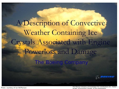
A <strong>Description</strong> <strong>of</strong> <strong>Convective</strong><br />
<strong>Weather</strong> <strong>Containing</strong> <strong>Ice</strong><br />
Crystals Associated with Engine<br />
Powerloss and Damage<br />
The Boeing Company<br />
Boeing Proprietary Data<br />
1<br />
Photo: courtesy <strong>of</strong> Ian McPherson<br />
The Boeing Company acknowledges the contributions <strong>of</strong> J. Walter<br />
Strapp, Environment Canada, to this presentation
Introduction<br />
<br />
<br />
<br />
<br />
<br />
<br />
<br />
This presentation is intended to enhance pilots’ awareness<br />
<strong>of</strong> ice crystal icing conditions where engine events have<br />
occurred<br />
High altitude ice crystals in convective weather have been<br />
recently recognized to be a cause <strong>of</strong> engine powerloss and<br />
engine damage<br />
The term “icing conditions” has always been used to refer<br />
to conditions where supercooled liquid drops adhere to<br />
airframe surfaces – typically altitudes 22,000 feet and<br />
below<br />
“<strong>Ice</strong> crystal icing” does not affect cold airframe surfaces,<br />
only engine surfaces<br />
Traditional thunderstorm avoidance procedures may help<br />
avoid ice crystals, but…<br />
It is not practical to avoid all ice crystal conditions, as the<br />
particles may not be detected by aviation radar<br />
There are clues to watch for to recognize these crystal icing<br />
conditions<br />
Reference: AIAA 2006-0206 “<strong>Ice</strong> Particle Threat to Engines in Flight”<br />
Boeing Proprietary Data<br />
2
What is convective weather?<br />
<strong>Convective</strong> weather is caused by deep lifting and condensation<br />
<strong>of</strong> air in an unstable atmosphere, sometimes resulting in<br />
one or more <strong>of</strong> the following:<br />
• deep cloud and large anvil regions<br />
• areas <strong>of</strong> strong wind shear and turbulence<br />
• lightning<br />
• high condensed water contents<br />
• heavy precipitation and hail<br />
Boeing Proprietary Data 3<br />
Photo: courtesy <strong>of</strong> Ian McPherson<br />
Boeing Proprietary Data
Types <strong>of</strong> <strong>Convective</strong> <strong>Weather</strong><br />
Deep convective clouds can be found on a variety <strong>of</strong> scales:<br />
• Isolated Cumulonimbus (CB), <strong>of</strong>ten thunderstorms, and can be<br />
thought <strong>of</strong> as the building block for convective weather.<br />
• CBs can organize into mesoscale convective complexes (MCCs)<br />
and squall lines, spanning hundreds <strong>of</strong> miles<br />
• Tropical storms are usually composed <strong>of</strong> convective elements<br />
rotating around a central low pressure center, leading to vast<br />
areas <strong>of</strong> mid-to-high altitude cloud ejected from convective<br />
cores<br />
• More severe tropical storms are known as hurricanes or<br />
typhoons<br />
Boeing includes all these types <strong>of</strong> clouds in the term<br />
convective weather; all contain ice crystals<br />
4<br />
Boeing Proprietary Data
Where do the ice crystals occur?<br />
<br />
<br />
<br />
<br />
<strong>Convective</strong> storms lift high concentrations <strong>of</strong> moisture to<br />
high altitude. In the mature stages <strong>of</strong> a thunderstorm, as<br />
the moisture passes through the freezing level,<br />
observations show that there is a rapid conversion <strong>of</strong> liquid<br />
to ice crystals – this is known as glaciation<br />
Vigorous circulation may cause ice crystals which are<br />
established in cloud at high altitude, to grow, redistribute,<br />
and deplete water droplets at lower altitudes. Therefore,<br />
deep convective cloud is dominated by ice crystals.<br />
These ice crystals exist at temperatures just colder than the<br />
freezing level, to well below -60C at the very top <strong>of</strong> the<br />
convective cloud<br />
Near the freezing level in a convective cloud, an airplane<br />
may encounter both supercooled liquid and frozen ice<br />
crystals – this is known as mixed phase conditions. In the<br />
early stages <strong>of</strong> convection, the cloud may be dominated by<br />
liquid.<br />
5<br />
Boeing Proprietary Data
What are ice crystals?<br />
<br />
<br />
<br />
Measurements have shown that ice crystals near the cores <strong>of</strong> deep<br />
convective clouds span micron (1 meter x 10 -6 ) to millimeter sizes, but<br />
the mass may be concentrated at very small sizes, with a mean mass<br />
“diameter” as small as 40 microns – or about the particulate size <strong>of</strong> flour.<br />
In this context, small crystals are speculated to have been created by<br />
freezing <strong>of</strong> small water droplets. Particles this small do not fall as<br />
precipitation.<br />
Other ice particles in a convective storm grow to larger sizes through:<br />
• vapor diffusion, although somewhat slowly. Vapor is supplied by the<br />
condensation <strong>of</strong> water vapor in the ascending air.<br />
• collision and sticking <strong>of</strong> individual crystals into ‘aggregates’ that can<br />
reach centimeters in size (snow). This process is highly active in<br />
most winter storms, but is also active in deep convective clouds. It<br />
does not require liquid cloud to be present. This is the major<br />
mechanism for particle growth in anvils.<br />
• sweeping out supercooled liquid droplets if they are present. The<br />
resulting particles, ultimately hail or graupel (small hail) tend to be<br />
more spherical, vary in size from 10ths <strong>of</strong> a mm to several<br />
centimeters, and have much higher mass than snowflakes <strong>of</strong> the<br />
same size. Supercooled liquid is therefore required sometime in their<br />
life-stage. Found in core updraft area <strong>of</strong> cloud system.<br />
6<br />
Boeing Proprietary Data
Hypothesis <strong>of</strong> the Environment that Causes<br />
Engine Events<br />
Typically found in regions with deep convective lifting<br />
and probable high ice water content<br />
• While diverting around reflectivity <strong>of</strong> isolated<br />
thunderstorm cores<br />
• In the broad outflow region <strong>of</strong> clouds associated with<br />
convective storms, convective storm complexes and<br />
tropical storms<br />
• <strong>Ice</strong> water contents can in theory reach 9 g/m3,<br />
• It is unknown what IWC/duration combination will cause<br />
an engine event<br />
• Liquid water need not be present<br />
7<br />
Boeing Proprietary Data
Using On-board <strong>Weather</strong> Radar to Detect Crystals<br />
<br />
<br />
<br />
<br />
<br />
Radar echoes have not been reported by the pilot at the location<br />
<strong>of</strong> the airplane in these engine events.<br />
In many cases, the aircraft was diverting around red echo regions<br />
<strong>of</strong> thunderstorms, at temperatures too cold for liquid water to<br />
exist<br />
Radar responds to particles according to the 6th power <strong>of</strong> their<br />
diameter, and is therefore able to detect large particles. Small<br />
particles, such as those 40 micron diameter particles in high<br />
concentrations near thunderstorms, are invisible to pilot’s radar,<br />
even though they may compose a major fraction <strong>of</strong> the total mass<br />
<strong>of</strong> the cloud.<br />
Regions <strong>of</strong> hail, graupel, and ice crystal aggregates convected to<br />
high altitude, can still display high reflectivities due to their large<br />
size. Research indicates these are very localized regions at high<br />
altitude.<br />
Areas <strong>of</strong> high mass concentration invisible to the radar can still<br />
exist away from these high reflectivity areas. This is graphically<br />
represented in the next figure.<br />
8<br />
Boeing Proprietary Data
Diagram <strong>of</strong> <strong>Ice</strong> Crystals in a <strong>Convective</strong> Cloud<br />
Typical Thunderstorm or <strong>Convective</strong> Storm<br />
Small lifting regions <strong>of</strong><br />
liquid water<br />
Region <strong>of</strong> high reflectivity<br />
(heavy precipitation, hail )<br />
<strong>Ice</strong> crystals – little or no<br />
radar reflectivity<br />
Sample Airplane Path<br />
Decreasing<br />
concentration <strong>of</strong><br />
liquid with altitude<br />
Freezing Level<br />
Region <strong>of</strong> high mass<br />
concentration and<br />
reflectivity<br />
Original diagram courtesy <strong>of</strong> Ge<strong>of</strong>f Coulson, ESB<br />
Above the freezing level, the convective cloud may be dominated by small ice<br />
particles, invisible to onboard weather radar<br />
9<br />
Boeing Proprietary Data
Satellite/Radar Can Detect <strong>Ice</strong> Crystals<br />
Horizontal Cross Section<br />
Vertical Cross Section<br />
Vertical Cross Section<br />
Freezing level<br />
•NASA TRMM satellite/radar combined space-borne sensors show the<br />
nature <strong>of</strong> a convective storm - colors are used for larger reflective<br />
particles such as hail, heavy snow, and rain.<br />
• Satellite/radar infers regions <strong>of</strong> particles with low reflectivity such<br />
as ice crystals <strong>of</strong> mean diameter <strong>of</strong> 40 microns – these appear white<br />
on the cross section<br />
•Even in this very vigorous storm few large reflective particles – rain,<br />
hail and graupel – occur at high altitude above the freezing level<br />
(limit <strong>of</strong> colored region).<br />
Boeing Proprietary Data<br />
10
High Altitude Flight in Convection where<br />
<strong>Ice</strong> Crystals Exist<br />
Satellite/radar<br />
Aircraft weather radar<br />
<br />
(Representation)<br />
Flight in ice crystals will look like visible moisture, but will not<br />
produce significant radar returns. Isolated high reflectivity targets<br />
ahead may be detected.<br />
Using tilt feature on radar should identify heavy rain below – a<br />
good indicator that dense ice crystals may exist above.<br />
11<br />
Boeing Proprietary Data
Images from a Tropical Storm Which Caused<br />
an Engine Event<br />
*<br />
* *<br />
* *<br />
*<br />
12:52<br />
visible in pilot’s radar<br />
not visible<br />
•In the infrared image (left), the aircraft flight path is indicated by<br />
asterisks, through the high altitude regions <strong>of</strong> a tropical storm. The event<br />
location is indicated in purple.<br />
•The accompanying satellite radar image (right) <strong>of</strong> the same storm, taken<br />
earlier than the engine event, shows that the upper altitudes <strong>of</strong> the storm,<br />
where the aircraft flew, were composed <strong>of</strong> small ice particles (blue), which<br />
would not have been visible on the onboard weather radar.<br />
12<br />
Boeing Proprietary Data
<strong>Ice</strong> Crystal Icing in an Engine<br />
<br />
<br />
Frozen ice crystals bounce <strong>of</strong>f cold surfaces, this is why<br />
airframe icing is not noticed during aircraft encounters with<br />
high altitude ice crystals.<br />
The physics <strong>of</strong> ice crystal accretion in the engine is not<br />
completely understood, however the accretion mechanism<br />
is thought to be:<br />
• High concentrations <strong>of</strong> crystals impinging on a warm surface<br />
such as a compressor vane melt and cool the surface. When<br />
the surface reaches zero degrees centigrade, ice accretion can<br />
begin to occur.<br />
• This phenomenon means ice accretion can occur well behind<br />
the fan in the core <strong>of</strong> the engine<br />
• <strong>Ice</strong> shed from compressor surfaces can cause engine instability<br />
such as surge and flameout, or engine damage.<br />
13<br />
Boeing Proprietary Data
<strong>Ice</strong> Crystal Engine Icing -- Theory<br />
<strong>Ice</strong> Crystals Bypass Fan<br />
• Bounce <strong>of</strong>f cold parts<br />
• No threat<br />
<strong>Ice</strong> Crystals Cool Booster<br />
• Small crystals heat/melt quickly<br />
• Results in a ice/water mixture<br />
<strong>Ice</strong> Accretion<br />
• Water/ice cools parts to 32F<br />
• Wetness allows ice to “stick”<br />
• <strong>Ice</strong> collects / accretes<br />
<strong>Ice</strong> crystals penetrate<br />
fan and booster and<br />
accrete downstream<br />
14<br />
Boeing Proprietary Data
Global View <strong>of</strong> Engine Powerloss Events<br />
<br />
<br />
<br />
Latitude<br />
A large number <strong>of</strong> events are occurring in the Asia Pacific region – this may be<br />
due to the fact that the highest sea surface temperatures are also found in this<br />
region<br />
High temperature air can contain more moisture – hence high concentrations<br />
lifted to high altitude and condensed<br />
Typically the engine powerloss events have occurred on days with temperatures<br />
10-20 degrees centigrade above standard day.<br />
80<br />
60<br />
40<br />
20<br />
0<br />
-20<br />
-40<br />
-60<br />
-80<br />
Highest average sea surface temperatures<br />
Concentration <strong>of</strong> events<br />
-150 -100 -50 0 50 100 150<br />
Longitude<br />
Boeing Proprietary Data<br />
15
TAT Anomaly<br />
●<br />
●<br />
●<br />
●<br />
●<br />
TAT anomaly has occurred in many cases near the time <strong>of</strong><br />
the engine powerloss events.<br />
The airplane total air temperature probe (TAT) erroneously<br />
reporting zero degrees C is known to be evidence <strong>of</strong> ice<br />
crystals in the atmosphere.<br />
This anomaly is due to ice crystals building up in the area<br />
where the thermocouple resides, where they are partly<br />
melted by the heater causing the zero degrees C reading<br />
In some cases, TAT has “flat-lined” at zero during a<br />
descent, and may be noticeable to pilots. In other cases,<br />
the error is more subtle, and not a reliable indicator to<br />
provide early warning to pilots <strong>of</strong> high concentrations <strong>of</strong> ice<br />
crystals.<br />
The TAT, although used as engine parameter, has been<br />
determined not to be a contributor to the powerloss events.<br />
Under these conditions, the engine control compensates for<br />
loss <strong>of</strong> TAT.<br />
16<br />
Boeing Proprietary Data
Pilot Reports<br />
Pilots have reported rain, sometimes ‘heavy rain’<br />
on the windscreen<br />
• Sometimes at impossibly cold temperatures,<br />
• This is believed to be the result <strong>of</strong> these small ice crystals<br />
melting on impact with the heated windscreen<br />
No observations <strong>of</strong> significant airframe icing<br />
Turning on landing lights at night and seeing<br />
reflective precipitation<br />
• It is likely they were seeing the larger particles even though<br />
they make up a smaller fraction <strong>of</strong> the population<br />
Hearing a different sound from rain<br />
• <strong>Ice</strong> crystals hitting the airframe sounded different than rain or<br />
hail<br />
Light to moderate turbulence<br />
17<br />
Boeing Proprietary Data
Recap – <strong>Ice</strong> Crystal Environment<br />
Above the freezing level in deep convective<br />
clouds, high concentrations <strong>of</strong> small ice crystals<br />
dominate the mass<br />
• These concentrations exceed 2 g/m3, which if it were a<br />
conventional icing threat, would be very severe<br />
• The majority <strong>of</strong> the crystals exist at small size – perhaps<br />
as small as flour.<br />
• Particles up to millimeter size do exist<br />
These small crystals are not visible on the pilot’s<br />
radar, however the pilot will see visible moisture<br />
18<br />
Boeing Proprietary Data
Summary: Indicators <strong>of</strong> <strong>Ice</strong> Crystal Encounters<br />
Flight in visible moisture near deep convective<br />
weather, without radar returns, and at temperatures<br />
below freezing is very likely ice crystal conditions.<br />
These conditions may also include:<br />
• Flying in the vicinity <strong>of</strong> a convective weather system /<br />
thunderstorm and above a region <strong>of</strong> heavy rain<br />
• No significant airframe icing<br />
• TAT probe frozen<br />
• <strong>Ice</strong> detector not detecting ice (when installed)<br />
• Appearance <strong>of</strong> rain on the windshield<br />
• Light to moderate turbulence<br />
19<br />
Boeing Proprietary Data
Recommendations<br />
<br />
<br />
<br />
<br />
It is not practical to avoid all ice crystal conditions; crystals<br />
may not be detected by aviation radar<br />
Normal thunderstorm avoidance procedures may help<br />
avoiding high ice crystal content regions<br />
These include:<br />
• Plan a flight path that avoids storm cells by at least 20 nautical<br />
miles.<br />
• Fly upwind <strong>of</strong> the storm<br />
• Avoid flying over a storm cell. A fully developed thunderstorm<br />
can reach altitudes <strong>of</strong> more than fifty thousand feet. Even<br />
when there are no radar returns, there may be significant<br />
moisture in the form <strong>of</strong> ice crystals at high altitudes.<br />
• Utilize the radar antenna tilt function to scan the reflectivity <strong>of</strong><br />
storms ahead. Recognize that heavy rain below indicates<br />
likely high concentrations <strong>of</strong> ice crystals above.<br />
ATC permitting, make a continuous descent at idle thrust.<br />
This decreases the exposure time to the ice crystal<br />
conditions.<br />
Reference: AIAA 2006-0206 “<strong>Ice</strong> Particle Threat to Engines in Flight”<br />
Boeing Proprietary Data<br />
20