2010 Treks
2010 Treks
2010 Treks

Create successful ePaper yourself
Turn your PDF publications into a flip-book with our unique Google optimized e-Paper software.
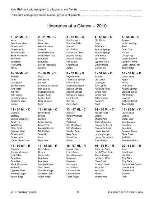
Your Philmont address given to all parents and friends .................................................................... _______<br />
Philmont's emergency phone number given to all parents ................................................................. _______<br />
Itineraries at a Glance – <strong>2010</strong><br />
1 - 51 Mi. - C 2 - 51 Mi. - C 3 - 52 Mi. - C 4 - 53 Mi. - C 5 - 56 Mi. - C<br />
Vaca Vaca Ute Springs Old Abreu Anasazi<br />
Deer Lake Mesa Deer Lake Webster Parks Crags Indian Writings<br />
Cimarroncito Webster Parks Sawmill Fish Camp Ponil<br />
Cimarroncito Sawmill Mt. Phillips Apache Springs Dean Cow<br />
Shaefers Pass Comanche Peak Comanche Creek Apache Springs Harlan<br />
Black Mountain Comanche Creek Apache Springs Wild Horse Ute Springs<br />
Beaubien Beaubien Apache Springs Mt. Phillips Upper Sawmill<br />
Beaubien Beaubien Fish Camp Cyphers Mine Lamberts Mine<br />
Fish Camp Carson Meadows Crater Lake Cimarroncito Upper Clarks Fork<br />
Abreu Zastrow Abreu Clarks Fork Tooth Ridge<br />
6 - 56 Mi. - C 7 - 56 Mi. - C 8 - 62 Mi. - C 9 - 51 Mi. - C 10 - 57 Mi. - C<br />
Anasazi Sioux Rayado River Anasazi Lovers Leap<br />
Ponil Dan Beard Toothache Springs Old Camp Aguila<br />
Dan Beard Iris Park Miners Park Dan Beard Abreu<br />
Seally Canyon Greenwood Canyon Lookout Meadow Rich Cabins Fish Camp<br />
Ring Place Rich Cabins Apache Springs Pueblano Ruins Apache Springs<br />
Iris Park Pueblano Ruins Apache Springs Ewells Park Crooked Creek<br />
Rich Cabins Copper Park Comanche Creek Ewells Park Mt. Phillips<br />
Pueblano Ruins Copper Park Clear Creek Baldy Skyline Sawmill<br />
Cimarron River Head of Dean Red Hills Pueblano Cathedral Rock<br />
Harlan Ponil Clarks Fork Ponil Tooth Ridge<br />
11 - 54 Mi. - C 12 - 61 Mi. - C 13 - 57 Mi. - C 14 - 60 Mi. - C 15 - 63 Mi. - C<br />
Olympia Lovers Leap Anasazi Rayado River Lovers Leap<br />
Zastrow Urraca Indian Writings Urraca Urraca<br />
Carson Meadows Zastrow Ponil Miners Park Crater Lake<br />
Agua Fria Lower Bonito Pueblano Black Mountain Bear Canyon<br />
Wild Horse Buck Creek Ute Meadows Comanche Creek Beaubien<br />
Clear Creek Crooked Creek Ute Meadows Comanche Peak Beaubien<br />
Cyphers Mine Mt. Phillips Head of Dean Lower Sawmill Crooked Creek<br />
Cimarroncito Sawmill New Dean Hunting Lodge Clear Creek<br />
Cimarroncito Vaca Dean Cow Upper Clarks Fork Red Hills<br />
Upper Clarks Fork Dean Cow Harlan Tooth Ridge Ponderosa Park<br />
16 - 65 Mi. - R 17 - 65 Mi. - R 18 - 67 Mi. - R 19 - 66 Mi. - R 20 - 63 Mi. - R<br />
Olympia Lovers Leap Lovers Leap Cimarron River Bent<br />
Carson Meadows Urraca Crater Lake Devils Wash Basin Dan Beard<br />
Lost Cabin Crater Lake Black Mountain Aspen Springs Iris Park<br />
Beaubien Beaubien Beaubien Lamberts Mine Ring Place<br />
Beaubien Beaubien Beaubien Clear Creek Ring Place<br />
Black Mountain Crooked Creek Porcupine Crooked Creek Greenwood Canyon<br />
Red Hills Clear Creek Mt. Phillips Beaubien Copper Park<br />
Cyphers Mine Thunder Ridge Cimarroncito Beaubien Copper Park<br />
Hunting Lodge Cathedral Rock Cimarroncito Abreu Elkhorn<br />
Tooth Ridge Tooth Ridge Tooth Ridge Miners Park Ponil<br />
<strong>2010</strong> ITINERARY GUIDE 17<br />
PHILMONT SCOUT RANCH, BSA