2010 Treks
2010 Treks
2010 Treks

You also want an ePaper? Increase the reach of your titles
YUMPU automatically turns print PDFs into web optimized ePapers that Google loves.
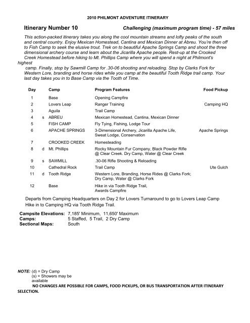
<strong>2010</strong> PHILMONT ADVENTURE ITINERARY<br />
Itinerary Number 10<br />
Challenging (maximum program time) - 57 miles<br />
This action-packed itinerary takes you along the cool mountain streams and lofty peaks of the south<br />
and central country. Enjoy Mexican Homestead, Cantina and Mexican Dinner at Abreu. You’re then off<br />
to Fish Camp to seek the elusive trout. Trek on to beautiful Apache Springs Camp and shoot the three<br />
dimensional archery course and learn about the Jicarilla Apache people. Rest-up at the Crooked<br />
Creek Homestead before hiking to Mt. Phillips Camp where you will spend a night at Philmont's<br />
highest<br />
camp. Finally, stop by Sawmill Camp for .30-06 shooting and reloading. Stop by Clarks Fork for<br />
Western Lore, branding and horse rides while you camp at the beautiful Tooth Ridge trail camp. Your<br />
last day takes you in to Base Camp via the Tooth of Time.<br />
Day Camp Program Features Food Pickup<br />
1 Base Opening Campfire<br />
2 Lovers Leap Ranger Training Camping HQ<br />
3 Aguila Trail Camp<br />
4 s ABREU Mexican Homestead, Cantina, Mexican Dinner<br />
5 FISH CAMP Fly Tying, Fishing, Lodge Tour<br />
6 APACHE SPRINGS 3-Dimensional Archery, Jicarilla Apache Life, Apache Springs<br />
Sweat Lodge, Conservation<br />
7 CROOKED CREEK Homesteading<br />
8 d Mt. Phillips Rocky Mountain Fur Company, Black Powder Rifle<br />
@ Clear Creek. Dry Camp, Water @ Clear Creek<br />
9 s SAWMILL .30-06 Rifle Shooting & Reloading<br />
10 Cathedral Rock Trail Camp Ute Gulch<br />
11 d Tooth Ridge Western Lore, Branding, Horse Rides @ Clarks Fork;<br />
Dry Camp, Water @ Clarks Fork<br />
12 Base Hike in via Tooth Ridge Trail,<br />
Awards Campfire<br />
Departs from Camping Headquarters on Day 2 for Lovers Turnaround to go to Lovers Leap Camp<br />
Hike in to Camping HQ via Tooth Ridge Trail.<br />
Campsite Elevations: 7,185' Minimum, 11,650' Maximum<br />
Camps:<br />
5 Staffed, 5 Trail, 2 Dry Camp<br />
Sectional Maps: South<br />
NOTE: (d) = Dry Camp<br />
(s) = Showers may be<br />
available<br />
NO CHANGES ARE POSSIBLE FOR CAMPS, FOOD PICKUPS, OR BUS TRANSPORTATION AFTER ITINERARY<br />
SELECTION.