Jennifer Pagach, CT DEP - ICLEI Local Governments for ...
Jennifer Pagach, CT DEP - ICLEI Local Governments for ...
Jennifer Pagach, CT DEP - ICLEI Local Governments for ...

You also want an ePaper? Increase the reach of your titles
YUMPU automatically turns print PDFs into web optimized ePapers that Google loves.
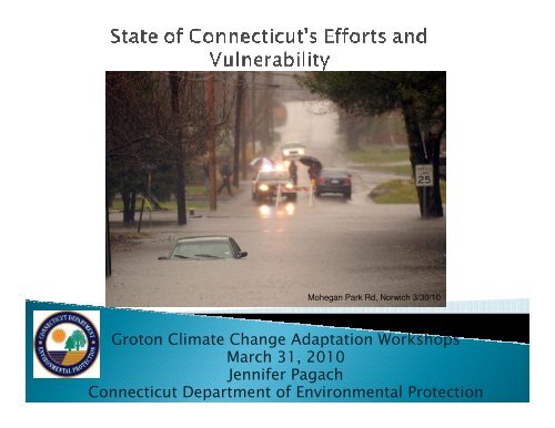
Mohegan Park Rd, Norwich 3/30/10<br />
Groton Climate Change Adaptation Workshops<br />
March 31, 2010<br />
<strong>Jennifer</strong> <strong>Pagach</strong><br />
Connecticut Department of Environmental Protection
Updates: State and Other Ef<strong>for</strong>ts<br />
Emerging Climate Science<br />
Scenario and Range Planning<br />
Inundation Scenarios<br />
State Assets and Vulnerability in<br />
Groton
New <strong>CT</strong> Climate Change Website- Adaptation<br />
Section<br />
Interns on Climate Change- Christine Ted<strong>for</strong>d,<br />
adaptation and website; Jonah Guerin, Fairfield<br />
Beach Case Study; Kyle Weaver, Sentinel Monitoring<br />
New Climate Change Group in Office of Long Island<br />
Sound Programs to look at policies, procedures and<br />
adaptation<br />
Salt Marsh Migration/Conservation Strategies<br />
Long Island Sound Study Stewardship- acquisition<br />
at Barn Island <strong>for</strong> salt marsh migration<br />
Updating Natural Hazard Mitigation Plan<br />
Coordinate with others-state, local, federal, NGOs
GSC Infrastructure Adaptation Subcommittees,<br />
C4 (GSC Staff) and Education Committee<br />
3 EPA Climate Ready Estuary Grants- Sentinel<br />
Monitoring Strategic Plan & Technical<br />
Assistance, Groton-Presenting at Restore<br />
America’s Estuaries, 1 st Bonn Resilient Cities<br />
Connecticut Conference on Natural Resources<br />
Sentinel Monitoring and adaptation strategies<br />
Madison Rotary Club- Climate Change and SLR<br />
in coastal areas, homeowners and stewards<br />
Yale Climate Summit- presentation on Groton
The Governor's Steering Committee on Climate Change<br />
Commissioner Amey Marrella, Department of<br />
Environmental Protection, Chair of GSC<br />
Chair Norma Glover, Connecticut Clean Energy Fund<br />
Commissioner Brenda L. Sisco, Department of<br />
Administrative Services<br />
Vice Chairman John W. "Jack" Betkoski III, Department of<br />
Public Utility Control<br />
Commissioner Joseph F. Marie, Department of<br />
Transportation<br />
Under Secretary John Mengacci, Office of Policy and<br />
Management<br />
http://ctclimatechange.com
Natural Resources and Ecological Habitats<br />
Co-chairs Bill Hyatt (<strong>CT</strong> <strong>DEP</strong>) and Adam Whelchel (The<br />
Nature Conservancy)<br />
Infrastructure<br />
Co-chairs Paul Stacey (<strong>CT</strong> <strong>DEP</strong>) and Denise Savageau<br />
(Greenwich)<br />
Agriculture<br />
Co-chairs Commissioner Prelli (<strong>CT</strong> DOAG) and Steve<br />
Reviczky (<strong>CT</strong> Farm Bureau)<br />
Public Health<br />
Co-chairs Pamela Kilbey-Fox (<strong>CT</strong> DPH) and Dr.<br />
Dennis McBride (Mil<strong>for</strong>d)<br />
Lots of help from Robert Kaliszewski and Roslyn<br />
Reeps!
Public Act No. 08-98 An Act Concerning<br />
Connecticut Global Warming Solutions<br />
<strong>CT</strong> Climate Change Adaptation Subcommittee<br />
<strong>for</strong>med under the Governor’s Steering<br />
Committee on Climate Change (GSC)<br />
Agriculture workgroup<br />
Natural Resources workgroup<br />
Infrastructure workgroup<br />
Public Health workgroup
Key Climate Drivers<br />
Temperature<br />
Precipitation<br />
Air Quality<br />
Top 5 Most Imperiled<br />
Planning Areas or<br />
Features<br />
Maple Syrup<br />
Dairy<br />
Warm Weather Produce<br />
Shellfish<br />
Apple and Pear<br />
Production<br />
Opportunities<br />
Longer Growing Season<br />
Biofuels<br />
Witch Hazel<br />
Grape/Wine Production
Key Climate Drivers<br />
Precipitation, including<br />
extreme precipitation<br />
events<br />
Sea level rise, where<br />
applicable<br />
Most Imperiled<br />
Planning Areas<br />
Coastal Flood Control and<br />
Protection<br />
Dams and Levees<br />
Stormwater<br />
Transportation<br />
Facilities and Buildings<br />
Wastewater
identified river and coastal<br />
flooding as primary impact<br />
investment in land-based<br />
best management practices<br />
(BMP) are essential to water<br />
quality and quantity<br />
natural defenses, such as<br />
barrier beaches and tidal<br />
marshes, provide a buffer<br />
against sea level rise and<br />
storm surges
Key Climate Drivers<br />
Temperature<br />
Precipitation<br />
Sea Level Rise<br />
Most Imperiled Habitats<br />
Cold Water Streams<br />
Tidal Marsh<br />
Open Water Marine<br />
Beaches and Dunes<br />
Freshwater Wetlands<br />
Offshore Islands<br />
Major Rivers<br />
Forested Swamps
Five species of Birds: including seaside sparrow and piping<br />
plover<br />
Three species of Reptiles & Amphibians: including bog turtle<br />
and diamond back terrapin<br />
16 Invertebrate species: including lobster and Atlantis<br />
fritillary<br />
Six species of Fish: including brook trout and rainbow smelt<br />
One Mammal: least shrew<br />
44 Plant species: including dwarf mistletoe and balsam fir
Fragmentation eliminates biological corridors (aquatic<br />
and terrestrial) that link habitats, which will reduce the<br />
ability of plants and animals to migrate and adapt as the<br />
climate changes.<br />
Invasive species will likely increase with climate change<br />
(19 spp. specifically identified).<br />
Forests—the competitive advantage may shift to the<br />
more southerly oak-hickory mix over northern<br />
hardwoods (sugar maple, yellow birch, beech).<br />
Increased water temperatures—abundance and<br />
distribution of coldwater species may decline and<br />
warmwater species may increase.
Sea Level Rise and severe coastal storms– may decrease<br />
shoreline habitat<br />
Some bird species will benefit from milder winters and<br />
extended breeding seasons, whereas others, such as northern<br />
species associated with <strong>for</strong>est habitats will decline.<br />
Larger more adaptable mammal species (e.g., deer) may<br />
benefit from climate change, whereas smaller less mobile<br />
species (e.g., New England cottontail) may become isolated<br />
and decrease.<br />
Species of amphibians or invertebrates associated with<br />
ephemeral aquatic habitats such as vernal pools are<br />
particularly vulnerable.<br />
Synchrony between plants and native pollinators may change.
Phenology is the study of the response of living organisms to the seasons<br />
and climatic changes to the environment in which they live.
Climate drivers include temperature and<br />
precipitation<br />
Vector- Associated Diseases<br />
Food Safety-- Extreme storm events will increase<br />
contaminants in runoff impacting shellfish<br />
Air Quality<br />
◦ Increased ozone exposure leads to asthma and allergen<br />
susceptibility<br />
◦ EJ groups, the elderly and people who work outside are<br />
most susceptible<br />
PH Infrastructure<br />
◦ Extreme storm events may increase the need <strong>for</strong><br />
emergency medical services<br />
◦ Increases occurrence of >90 o days may shift sheltering<br />
needs <strong>for</strong> homeless and elderly
Air Quality<br />
◦ Increased ozone exposure leads to asthma and allergen<br />
susceptibility<br />
◦ EJ groups, the elderly and people who work outside are<br />
most susceptible<br />
Extreme Heat<br />
◦ heat cramps, heat exhaustion, heat stroke, Death<br />
Ticks<br />
Lyme disease, Rocky Mountain Spotted Fever<br />
Mosquitoes<br />
West Nile Virus<br />
Eastern Equine Encephalitis
Extreme storm events can increase<br />
occurrences of combined sewer overflows,<br />
septic failure, etc.<br />
Rising sea levels could lead to salt intrusion<br />
of coastal ground water supplies<br />
Changing precipitation patterns can impact<br />
surface and ground water supplies
New definition of resiliency?
Norwich boat launch-head of Thames<br />
National Guard Activated To Battle<br />
Flood Waters; Southeastern<br />
Connecticut Getting The Worst Of It<br />
March 30, 2010
Yantic Crests At Third-<br />
Highest Level Ever Recorded
HARTFORD — Gov. M. Jodi Rell says<br />
Connecticut officials are preparing to respond to<br />
potential flooding across the state as a two-day<br />
storm is expected to dump up to 8 inches of rain<br />
in some areas.<br />
Rell ordered the state emergency operations<br />
center to open Monday morning and monitor the<br />
storm.<br />
Federal Emergency Management Agency<br />
officials are also expected to be in southwestern<br />
Connecticut on Monday morning to assess<br />
major damage caused by a storm two weeks<br />
ago.<br />
<br />
The Aquarion Water Company is draining off some excess<br />
water in the Dam in Mystic, which police said may cause<br />
water levels near Cove Road. Residents in that area have not<br />
been evacuated, but are being advised of the potentially<br />
higher levels of water "just in case" they choose to leave,<br />
Brennan said.<br />
Storms Flood Basements, Roads<br />
Norwich declares a state of emergency
The Culprit
King<br />
Triton
As Sea Level Rises, so does the groundwater<br />
table, so areas that do not directly flood may<br />
drown as water table raises.<br />
At what frequency of flooding does current<br />
infrastructure become non-functional, like<br />
airport, trains, etc.?<br />
Is it possible to flood proof these?<br />
What about UCONN Avery Point?
All around the world, there are people dealing<br />
with climate change adaptation<br />
There are people who have dealt with this<br />
longer than us….
New Moore Island in the Sunderbans has been completely submerged, said Sugata Hazra, a<br />
professor of oceanography at Jadavpur University, in Calcutta. Its disappearance has been<br />
confirmed by satellite imagery and sea patrols, he said.<br />
"What these two countries could not achieve from years of talking, has been resolved by global<br />
warming," said Mr Hazra.<br />
Scientists at the School of Oceanographic Studies at the university have noted an alarming<br />
increase in the rate at which sea levels have risen over the past decade in the Bay of Bengal.<br />
Until 2000, the sea levels rose about 0.12 inches a year, but over the last decade they have<br />
been rising about 0.2 inches annually, he said.<br />
Another nearby island, Lohachara, was submerged in 1996, <strong>for</strong>cing its inhabitants to move to<br />
the mainland, while almost half the land of Ghoramara island was underwater, he said. At least<br />
10 other islands in the area were at risk as well, Mr Hazra said.<br />
Bangladesh, a low-lying delta nation of 150 million people, is one of the countries worstaffected<br />
by global warming. Officials estimate 18 per cent of Bangladesh's coastal area will be<br />
under water and 20 million people will be displaced if sea levels rise 3.3 feet by 2050, as<br />
projected by some climate models.<br />
India and Bangladesh both claimed the uninhabited New Moore Island, which was about 3.5<br />
kilometers (2 miles) long and 1.5 miles wide. Bangladesh referred to the island as South<br />
Talpatti.
Since last workshop, more SLR modeling:<br />
22 Mar 2010: Analysis<br />
The Secret of Sea Level Rise:<br />
It Will Vary Greatly by Region<br />
As the world warms, sea levels could easily rise three to six feet this<br />
century. But increases will vary widely by region, with prevailing<br />
winds, powerful ocean currents, and even the gravitational pull of the<br />
polar ice sheets determining whether some coastal areas will be<br />
inundated while others stay dry.<br />
by michael d. lemonick
Science keeps emerging, so plan <strong>for</strong> that<br />
Plan <strong>for</strong> wide range of scenarios over time<br />
Modeling under different conditions can help<br />
frame how we are vulnerable<br />
What are your short, mid and long term<br />
concerns?<br />
For these inundation scenarios, very close to<br />
what state adaptation subcommittees are<br />
using
Modeled 10 and 100 year storms<br />
This is based on frequency of occurrence<br />
<strong>Local</strong> factors like plate compression taken<br />
into account<br />
Used various planning horizons and<br />
predictions- Sam & Paul to detail more<br />
2050 low and higher scenario (10” and 20”)<br />
2080 low and higher (17” and 55”)
Corresponding Values<br />
Added Hurricane<br />
Surge Inundation<br />
Categories
<strong>DEP</strong> and State Owned Property
ROAD ACCESS AND<br />
PARKING LOT AT BLUFF<br />
POINT<br />
2050 w/ high and low slr, at 10<br />
and 100 yr storm
Underground<br />
Storage Tanks
Blue and Pink- 2050 Low and High SLR<br />
Green and Orange- 2080 Low and High SLR
We can start to model our vulnerabilities and<br />
make projections<br />
We can make correlations- might the effects<br />
of an uncommon occurrence (hurricane) be<br />
similar to a more frequent future occurrence<br />
(10 year storm)<br />
We can plan- short, mid and long term,<br />
planning is an iterative process<br />
We can start integrating into our day to day<br />
We have tools, and yes, we are the State…<br />
And We Are Here to Help!
<strong>Jennifer</strong> <strong>Pagach</strong>, <strong>CT</strong> <strong>DEP</strong><br />
<strong>Jennifer</strong>.pagach@ct.gov<br />
(860) 424-3295