ArcGIS Hydro Data Model Data Dictionary - Center for Research in ...
ArcGIS Hydro Data Model Data Dictionary - Center for Research in ...
ArcGIS Hydro Data Model Data Dictionary - Center for Research in ...

Create successful ePaper yourself
Turn your PDF publications into a flip-book with our unique Google optimized e-Paper software.
<strong>ArcGIS</strong> <strong>Hydro</strong> <strong>Data</strong> <strong>Model</strong> <strong>Data</strong> <strong>Dictionary</strong><br />
By David R. Maidment<br />
<strong>Center</strong> <strong>for</strong> <strong>Research</strong> <strong>in</strong> Water Resources<br />
University of Texas at Aust<strong>in</strong><br />
May 24, 2001<br />
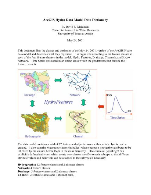
This document lists the classes and attributes of the May 24, 2001, version of the <strong>ArcGIS</strong> <strong>Hydro</strong><br />
data model and describes what they represent. It is organized accord<strong>in</strong>g to the feature classes <strong>in</strong><br />
each of the four feature datasets <strong>in</strong> the model: <strong>Hydro</strong> Features, Dra<strong>in</strong>age, Channels, and <strong>Hydro</strong><br />
Network. Time Series are stored <strong>in</strong> an object class with<strong>in</strong> the geodatabase but outside the<br />
feature datasets.<br />
The data model conta<strong>in</strong>s a total of 27 feature and object classes with<strong>in</strong> which objects can be<br />
created. It also conta<strong>in</strong>s 6 abstract classes (<strong>in</strong> italics) whose purpose is to gather attributes to be<br />
<strong>in</strong>herited by the classes below them <strong>in</strong> the class hierarchy. One classes (<strong>Hydro</strong>Edge) has<br />
explicitly def<strong>in</strong>ed subtypes, which create new classes specific to each subtype so that different<br />
attribute values and behaviors can be attached to the subtypes if necessary.<br />
<strong>Hydro</strong>graphy: 12 feature classes and 2 abstract classes<br />
Network: 4 feature classes<br />
Dra<strong>in</strong>age: 5 feature classes and 2 abstract classes<br />
Channel: 2 feature classes and 1 abstract class.
Objects: 4 object classes and 1 abstract class<br />
<strong>Hydro</strong>graphy <strong>Data</strong>Set Classes<br />
2
Class<br />
(Type)<br />
<strong>Hydro</strong><br />
Feature<br />
(Abstract)<br />
<strong>Hydro</strong>grapy<br />
(Abstract)<br />
Inherits<br />
From<br />
Feature<br />
<strong>Hydro</strong><br />
Feature<br />
<strong>Hydro</strong>Po<strong>in</strong>t <strong>Hydro</strong>graphy<br />
(Po<strong>in</strong>t)<br />
<strong>Hydro</strong>L<strong>in</strong>e<br />
<strong>Hydro</strong>Area<br />
Waterbody<br />
<strong>Hydro</strong>graphy<br />
(Polyl<strong>in</strong>e)<br />
<strong>Hydro</strong>graphy<br />
(Polygon)<br />
<strong>Hydro</strong>Area<br />
(Polygon)<br />
Attribute Attribute<br />
Type<br />
Description<br />
Abstract class hold<strong>in</strong>g common<br />
attributes and methods <strong>for</strong><br />
<strong>Hydro</strong>Features<br />
<strong>Hydro</strong>ID Integer Unique feature identifier with<strong>in</strong> a<br />
geodatabase<br />
<strong>Hydro</strong>Code Str<strong>in</strong>g Unique feature identifier with<strong>in</strong> a<br />
set of geodatabases<br />
Abstract class hold<strong>in</strong>g common<br />
attributes and methods <strong>for</strong><br />
<strong>Hydro</strong>graphy features<br />
Ftype Str<strong>in</strong>g Descriptor <strong>for</strong> feature type. Can be<br />
expanded us<strong>in</strong>g Subtypes<br />
Name Str<strong>in</strong>g Geographic name<br />
Po<strong>in</strong>t features from map<br />
hydrography and <strong>in</strong>ventory sources<br />
JunctionID Integer <strong>Hydro</strong>ID of the <strong>Hydro</strong>Junction<br />
with which this po<strong>in</strong>t is associated<br />
HasZ = False<br />
HasM = False<br />
Area features from map<br />
hydrography<br />
A merg<strong>in</strong>g of <strong>Hydro</strong>Areas that<br />
constitute a s<strong>in</strong>gle waterbody<br />
AreaSqKm Double Area <strong>in</strong>dependent of map units<br />
JunctionID Integer <strong>Hydro</strong>ID of the <strong>Hydro</strong>Junction<br />
which is outlet of this waterbody<br />
3
Class<br />
(Type)<br />
Dam<br />
Bridge<br />
Structure<br />
Monitor<strong>in</strong>g<br />
Po<strong>in</strong>t<br />
Water<br />
Withdrawal<br />
Water<br />
Discharge<br />
UserPo<strong>in</strong>t<br />
<strong>Hydro</strong><br />
ResponseUnit<br />
Inherits<br />
From<br />
<strong>Hydro</strong>Po<strong>in</strong>t<br />
(Po<strong>in</strong>t)<br />
<strong>Hydro</strong>Po<strong>in</strong>t<br />
(Po<strong>in</strong>t)<br />
<strong>Hydro</strong>Po<strong>in</strong>t<br />
(Po<strong>in</strong>t)<br />
<strong>Hydro</strong>Po<strong>in</strong>t<br />
(Po<strong>in</strong>t)<br />
<strong>Hydro</strong>Po<strong>in</strong>t<br />
(Po<strong>in</strong>t)<br />
<strong>Hydro</strong>Po<strong>in</strong>t<br />
(Po<strong>in</strong>t)<br />
<strong>Hydro</strong>Po<strong>in</strong>t<br />
(Po<strong>in</strong>t)<br />
<strong>Hydro</strong><br />
Feature<br />
(Polygon)<br />
Attribute<br />
Attribute<br />
Type<br />
Description<br />
A structure creat<strong>in</strong>g a pond or<br />
reservoir stor<strong>in</strong>g water<br />
A structure carry<strong>in</strong>g a road across<br />
a stream<br />
Any other k<strong>in</strong>d of water resources<br />
structure<br />
A permanent measurement station<br />
or the location of a sampl<strong>in</strong>g po<strong>in</strong>t<br />
Po<strong>in</strong>t of withdrawal of water,<br />
usually with a pipe and pump<br />
system<br />
Po<strong>in</strong>t of discharge of water, e.g.<br />
wastewater discharge, irrigation<br />
return flow<br />
Any other po<strong>in</strong>t of <strong>in</strong>terest<br />
Any subdivision of the landscape<br />
used <strong>for</strong> surface water balance<br />
account<strong>in</strong>g (e.g. climate cells, soil<br />
& land use polygons,…)<br />
AreaSqKm Double Area <strong>in</strong>dependent of map units<br />
4
<strong>Hydro</strong> Network Feature <strong>Data</strong>set Classes<br />
Class<br />
(Type)<br />
<strong>Hydro</strong>Edge<br />
Inherits<br />
From<br />
Complex<br />
Edge<br />
Feature<br />
Attribute<br />
HasZ = False<br />
HasM = True<br />
Attribute<br />
Type<br />
Description<br />
The l<strong>in</strong>es connected by junctions<br />
<strong>in</strong> the <strong>Hydro</strong>Network<br />
<strong>Hydro</strong>ID Integer Unique feature identifier with<strong>in</strong> a<br />
geodatabase<br />
<strong>Hydro</strong>Code Str<strong>in</strong>g Unique feature identifier <strong>in</strong> a set<br />
of geodatabases<br />
ReachCode Str<strong>in</strong>g Reach identifier<br />
Name Str<strong>in</strong>g Geographic name<br />
LengthKm Double Stores <strong>Hydro</strong>Edge length<br />
<strong>in</strong>dependently of map units<br />
LengthDown Double Length along shortest path to a<br />
downstream reference location<br />
FlowDir<br />
<strong>Hydro</strong>Flow<br />
Directions<br />
CVD<br />
Labels flow direction:<br />
Un<strong>in</strong>itialized = 0, WithDigitized<br />
= 1, Aga<strong>in</strong>stDigitized = 2,<br />
Indeterm<strong>in</strong>ate = 3; <strong>in</strong>itial value =<br />
1<br />
5
<strong>Hydro</strong><br />
Junction<br />
Schematic<br />
Node<br />
Schematic<br />
L<strong>in</strong>k<br />
Simple<br />
Junction<br />
Feature<br />
<strong>Hydro</strong><br />
Feature<br />
(Po<strong>in</strong>t)<br />
<strong>Hydro</strong><br />
Feature<br />
(Polyl<strong>in</strong>e)<br />
FType Str<strong>in</strong>g Descriptor <strong>for</strong> feature type. Can<br />
be expanded us<strong>in</strong>g Subtypes<br />
EdgeType Subtype<br />
CV<br />
Doma<strong>in</strong><br />
Flowl<strong>in</strong>e = 1, Shorel<strong>in</strong>e = 2, <strong>in</strong>tial<br />
= 1<br />
Enabled<br />
Coded<br />
Value<br />
Doma<strong>in</strong><br />
0 = Disabled, 1 = Enabled<br />
(<strong>in</strong>herited attribute from<br />
ComplexNetworkFeature)<br />
HasZ = False<br />
HasM = True<br />
Junctions between <strong>Hydro</strong>Edges<br />
mark<strong>in</strong>g outflow po<strong>in</strong>ts from<br />
Waterbodies, or <strong>for</strong> other<br />
purposes, such as a S<strong>in</strong>k<br />
<strong>Hydro</strong>ID Integer Unique feature identifier with<strong>in</strong> a<br />
geodatabase<br />
<strong>Hydro</strong>Code Str<strong>in</strong>g Unique feature identifier <strong>in</strong> a set<br />
of geodatabases<br />
NextDownID Integer <strong>Hydro</strong>ID of next downstream<br />
<strong>Hydro</strong>Junction<br />
LengthDown Double Length along shortest path to a<br />
downstream reference location<br />
Dra<strong>in</strong>Area Double Upstream dra<strong>in</strong>age area<br />
FType Str<strong>in</strong>g Descriptor <strong>for</strong> feature type. Can<br />
be expanded us<strong>in</strong>g Subtypes<br />
Enabled<br />
Ancillary<br />
Role<br />
Coded<br />
Value<br />
Doma<strong>in</strong><br />
Coded<br />
Value<br />
Doma<strong>in</strong><br />
0 = Disabled, 1 = Enabled<br />
(<strong>in</strong>herited attribute from Simple<br />
Junction Feature)<br />
0 = None<br />
1= Source<br />
2 = S<strong>in</strong>k<br />
(<strong>in</strong>herited attribute from Simple<br />
Junction Feature)<br />
Po<strong>in</strong>ts <strong>in</strong> a schematic network<br />
connect<strong>in</strong>g <strong>Hydro</strong> Features<br />
FeatureID Integer <strong>Hydro</strong>ID of the associated <strong>Hydro</strong><br />
Feature<br />
L<strong>in</strong>es <strong>in</strong> a schematic network<br />
connect<strong>in</strong>g <strong>Hydro</strong> Features<br />
FromNode Integer <strong>Hydro</strong>ID of the SchematicNode<br />
at from end of l<strong>in</strong>k<br />
ToNode Integer <strong>Hydro</strong>ID of the SchematicNode<br />
at to end of l<strong>in</strong>k<br />
6
Dra<strong>in</strong>age Feature <strong>Data</strong>set Classes<br />
7
Class<br />
(type)<br />
Dra<strong>in</strong>age<br />
Feature<br />
(Abstract)<br />
Dra<strong>in</strong>age<br />
Po<strong>in</strong>t<br />
(Po<strong>in</strong>t)<br />
Dra<strong>in</strong>age<br />
L<strong>in</strong>e<br />
(Polyl<strong>in</strong>e)<br />
Dra<strong>in</strong>age<br />
Area<br />
(Abstract)<br />
Catchment<br />
(Polygon)<br />
Watershed<br />
(Polygon)<br />
Bas<strong>in</strong><br />
(Polygon)<br />
Inherits<br />
from<br />
<strong>Hydro</strong><br />
Feature<br />
(Abstract)<br />
Dra<strong>in</strong>age<br />
Feature<br />
Dra<strong>in</strong>age<br />
Feature<br />
Dra<strong>in</strong>age<br />
Feature<br />
Dra<strong>in</strong>age<br />
Area<br />
Dra<strong>in</strong>age<br />
Area<br />
Dra<strong>in</strong>age<br />
Area<br />
Attribute<br />
Attribute<br />
Type<br />
Description<br />
Abstract class <strong>for</strong> Dra<strong>in</strong>age<br />
System features<br />
Dra<strong>in</strong>ID Integer L<strong>in</strong>k between po<strong>in</strong>t, l<strong>in</strong>e and area<br />
features of a dra<strong>in</strong>age system (e.g.<br />
GridCode, Pfaffstetter number,<br />
HUC number)<br />
Po<strong>in</strong>t at the center of a DEM cell<br />
on a dra<strong>in</strong>age path, usually seed<br />
po<strong>in</strong>t location <strong>for</strong> dra<strong>in</strong>age area<br />
del<strong>in</strong>eation<br />
JunctionID Integer <strong>Hydro</strong>ID of the associated<br />
<strong>Hydro</strong>Junction<br />
L<strong>in</strong>e through the centers of the<br />
DEM cells on a dra<strong>in</strong>age path<br />
Abstract class <strong>for</strong> common<br />
dra<strong>in</strong>age area attributes<br />
AreaSqKm Double Dra<strong>in</strong>age area <strong>in</strong>dependent of map<br />
units<br />
JunctionID Integer <strong>Hydro</strong>ID of the associated<br />
<strong>Hydro</strong>Junction, which is the<br />
dra<strong>in</strong>age area outlet location<br />
NextDownID Integer <strong>Hydro</strong>ID of the next downstream<br />
area <strong>in</strong> this dra<strong>in</strong>age area class<br />
An elementary dra<strong>in</strong>age area<br />
produced by a uni<strong>for</strong>m process of<br />
landscape subdivision<br />
Any subdivision of the landscape<br />
<strong>in</strong>to dra<strong>in</strong>age areas<br />
A set of standardized watersheds<br />
<strong>for</strong> data archiv<strong>in</strong>g and delivery<br />
8
Channel Feature <strong>Data</strong>set Classes<br />
9
Class<br />
(Type)<br />
Channel<br />
Feature<br />
(Abstract<br />
class)<br />
ProfileL<strong>in</strong>e<br />
(3D<br />
Polyl<strong>in</strong>eM)<br />
CrossSection<br />
(3D<br />
Polyl<strong>in</strong>eM)<br />
Inherits<br />
From<br />
<strong>Hydro</strong><br />
Feature<br />
Channel<br />
Feature<br />
Attribute<br />
Attribute<br />
Type<br />
Description<br />
Abstract class <strong>for</strong> gather<strong>in</strong>g common<br />
channel attributes<br />
ReachCode Str<strong>in</strong>g Reach identifier<br />
RiverCode Str<strong>in</strong>g River identifier<br />
HasZ=True<br />
Longitud<strong>in</strong>al profile of the channel<br />
HasM=True<br />
FType Str<strong>in</strong>g Descriptor <strong>for</strong> types of ProfileL<strong>in</strong>es<br />
(Thalweg, Bankl<strong>in</strong>e, Streaml<strong>in</strong>e)<br />
ProfOrig<strong>in</strong> Str<strong>in</strong>g Descriptor of the orig<strong>in</strong> of the data<br />
used to <strong>for</strong>m the ProfileL<strong>in</strong>e<br />
CSCode Str<strong>in</strong>g CrossSection identifier<br />
JunctionID Integer <strong>Hydro</strong>ID of the associated<br />
<strong>Hydro</strong>Junction<br />
ProfileM Double Location of the CrossSection us<strong>in</strong>g<br />
ProfileL<strong>in</strong>e measure<br />
CSOrig<strong>in</strong> Str<strong>in</strong>g Descriptor of the construction<br />
method of CrossSection. Possible<br />
subtpes:<br />
3Dtype = 0<br />
Polyl<strong>in</strong>eType = 1<br />
L<strong>in</strong>eType = 2<br />
Po<strong>in</strong>tType = 3<br />
LocationType = 4<br />
10
Object Classes<br />
CrossSectionPo<strong>in</strong>t Object class:<br />
Class<br />
(Type)<br />
CrossSection<br />
Po<strong>in</strong>t<br />
Inherits<br />
From<br />
Object<br />
Attribute<br />
Attribute<br />
Type<br />
Description<br />
CSCode Str<strong>in</strong>g CrossSection identifier<br />
CrossM Double CrossSection measure po<strong>in</strong>t location<br />
Elevation Double Elevation of CrossSection po<strong>in</strong>t<br />
above mean sea level<br />
<strong>Hydro</strong>Event Object classes:<br />
Class<br />
(Type)<br />
<strong>Hydro</strong>Event<br />
(Abstract)<br />
<strong>Hydro</strong>Po<strong>in</strong>t<br />
Event<br />
<strong>Hydro</strong>L<strong>in</strong>e<br />
Event<br />
Inherits<br />
From<br />
Object<br />
<strong>Hydro</strong>Event<br />
<strong>Hydro</strong>Event<br />
Attribute Attribute<br />
Type<br />
Description<br />
Abstract class to store attributes<br />
and methods <strong>for</strong> events<br />
ReachCode Str<strong>in</strong>g Attribute identifier <strong>for</strong> the l<strong>in</strong>e on<br />
which measure is def<strong>in</strong>ed (could<br />
be changed to RiverCode if<br />
measure is <strong>in</strong> river miles or km<br />
A po<strong>in</strong>t event<br />
Measure Double Measure location of the event<br />
A l<strong>in</strong>e event<br />
FMeasure Double Measure location of the start of<br />
the l<strong>in</strong>e event<br />
TMeasure Double Measure location of the end of<br />
the l<strong>in</strong>e event<br />
Offset Double Offset distance of event from l<strong>in</strong>e<br />
11
Time Series Object class<br />
Class<br />
(Type)<br />
TimeSeries<br />
Inherits From Attribute Attribute<br />
Type<br />
Description<br />
Object<br />
FeatureID Integer <strong>Hydro</strong>ID of the <strong>Hydro</strong><br />
Feature described by a<br />
time series<br />
TSType Str<strong>in</strong>g Type of time series data<br />
TSDateTime Date Time at which TSValue<br />
applies<br />
TSValue Double Time series data value<br />
Relationships<br />
Orig<strong>in</strong> Class Primary Dest<strong>in</strong>ation Primary Multiplicity Name<br />
Key Field Class Key Field<br />
<strong>Hydro</strong> <strong>Hydro</strong>ID Watershed JunctionID 1 to 1 WatershedhasJunction<br />
Junction<br />
<strong>Hydro</strong> <strong>Hydro</strong>ID Waterbody JunctionID 1 to 1 WaterbodyhasJunction<br />
Junction<br />
CrossSection CSCode CrossSection<br />
Po<strong>in</strong>t<br />
CSCode 1 to 1..* CrossSectionhasPo<strong>in</strong>ts<br />
12