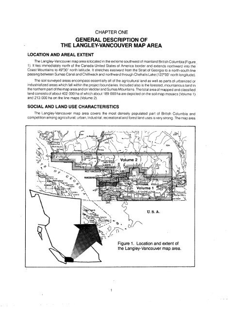
- Page 1 and 2: Soils of the Langley-Vancouver Map
- Page 3 and 4: Province of British Columbi a Minis
- Page 5 and 6: INTRODUCTION The first soil survey
- Page 7 and 8: HOW TO USE THE SOIL MAPS AND REPORT
- Page 9 and 10: INTRODUCTION HOW TO USE THE SOIL MA
- Page 11 and 12: Lulu Soils (LU) Lumbum Soils (LM) L
- Page 13 and 14: LIST OF FIGURES Figure 1 Location a
- Page 15 and 16: LIST OF PLATES (Continued) Plate 30
- Page 17: LIST OF APPENDICES Appendix A Avera
- Page 21 and 22: during the growing season (May to S
- Page 23 and 24: Plate 3 Dyke along the Fraser River
- Page 25 and 26: SURFICIAL GEOLOGIC DEPOSITS Several
- Page 27 and 28: ---------------- TABLE 2 The relati
- Page 29 and 30: CHAPTER TWO SOIL CLASSIFICATION AND
- Page 31 and 32: CHAPTER THREE DESCRIPTION OF THE SO
- Page 33 and 34: UPLANDS STREA M Figure 6. A schemat
- Page 35 and 36: Description of the Soils
- Page 37 and 38: n Plate 5 Abbotsford soil profile (
- Page 39 and 40: - _ I Plate 6 Landscape typical of
- Page 41 and 42: General Soil Description : Albion s
- Page 43 and 44: ANNACIS SOILS (AS) Location and Ext
- Page 45 and 46: ARNOLD SOILS . (AR) Location and Ex
- Page 47 and 48: BATES SOILS (BT) Location and Exten
- Page 49 and 50: BEHARREL SOILS . (BL) Location and
- Page 51 and 52: BERRY SOILS (BR) Location and Exten
- Page 53 and 54: BLANEY SOILS . (BE) Location and Ex
- Page 55 and 56: BONSON SOILS (BN) Location and Exte
- Page 57 and 58: ' - -_) - r or - ' _ ti _ L , -~ s,
- Page 59 and 60: BUCKERFIELD SOILS (BK) Location and
- Page 61 and 62: Plate 13 Buntzen soil profiie -. -H
- Page 63 and 64: CALKINS SOILS (CN) Location and Ext
- Page 65 and 66: CAPILANO SOILS . (CP) Location and
- Page 67 and 68: CASCADE SOILS . (CC) Location and E
- Page 69 and 70:
CHEHALIS SOILS (CS) Location and Ex
- Page 71 and 72:
Plate 14 Cloverdale soil pro/0e fHu
- Page 73 and 74:
COLUMBIA SOILS Location and Extent
- Page 75 and 76:
COQUITLAM SOILS . (CO) Location and
- Page 77 and 78:
subsurface layers to extremely acid
- Page 79 and 80:
DEAS SOILS (DS) Location and Extent
- Page 81 and 82:
DELTA SOILS (DT) Location and Exten
- Page 83 and 84:
Plate 20 Dennett soil profile (Typi
- Page 85 and 86:
DEWDNEY SOILS (DW) Location and Ext
- Page 87 and 88:
DURIEU SOILS (DU) Location and Exte
- Page 89 and 90:
ELK SOILS (EK) Location and Extent
- Page 91 and 92:
EMBREE SOILS : (EM) Location and Ex
- Page 93 and 94:
ERROCK SOILS (ER) Location and Exte
- Page 95 and 96:
FADDEN SOILS (FD) Location and Exte
- Page 97 and 98:
FELLOWS SOILS . (FS) Location and E
- Page 99 and 100:
GLEN VALLEY SOIL S Location and Ext
- Page 101 and 102:
GOLDEN EARS SOILS . (GE) t . Locati
- Page 103 and 104:
GOODY SOILS (GY) Location and Exten
- Page 105 and 106:
GRIGG SOILS (GG ) Location and Exte
- Page 107 and 108:
GUICHON SOILS (GU) Location and Ext
- Page 109 and 110:
HAMMOND SOILS . (HA) Location and E
- Page 111 and 112:
HARRISON SOILS . (HR) Location and
- Page 113 and 114:
HAZELWOOD SOILS (HD) Location and E
- Page 115 and 116:
HERON SOILS (HN ) Location and Exte
- Page 117 and 118:
HOLLYBURN SOILS (HB) Location and E
- Page 119 and 120:
HOPEDALE SOILS (HP) Location and Ex
- Page 121 and 122:
JUDSON SOILS (JN) Location and Exte
- Page 123 and 124:
KENNEDY SOILS , -n Plate 26 A t ypi
- Page 125 and 126:
KENWORTHY SOILS (KW) Location and E
- Page 127 and 128:
KITTER SOILS (K) Location and Exten
- Page 129 and 130:
(L) Commonly Associated Soils : Del
- Page 131 and 132:
LANGLEY SOILS (LA) Location and Ext
- Page 133 and 134:
LEHMAN SOILS . (LH) Location and Ex
- Page 135 and 136:
LIONS SOILS (LS) Location and Exten
- Page 137 and 138:
LONZO CREEK SOILS ,(LZ) Location an
- Page 139 and 140:
(LU ) Pate 30 Lodgepole pine is a c
- Page 141 and 142:
LYNDEN SOILS (LY) Location and Exte
- Page 143 and 144:
L r4 . Li- -_, - Plate 32 Marble Hi
- Page 145 and 146:
MATHEWS SOILS (MW) Location and Ext
- Page 147 and 148:
=-'~ squi soil profile (Eluviated E
- Page 149 and 150:
McELVEE SOILS (ME) Location and Ext
- Page 151 and 152:
MILNER SOILS (ML) Location and Exte
- Page 153 and 154:
(M) General Land Use Comments : (1)
- Page 155 and 156:
General Land Use Comments : (1) Mur
- Page 157 and 158:
NEPTUNE SOILS (NP) Location and Ext
- Page 159 and 160:
(N) General Land Use Comments : (1)
- Page 161 and 162:
NIVEN SOILS (NN) Location and Exten
- Page 163 and 164:
PALISADE SOILS (PA) Location and Ex
- Page 165 and 166:
equired to ensure soil instability
- Page 167 and 168:
PELLY SOILS (Pl ) Location and Exte
- Page 169 and 170:
POIGNANT SOILS (PT) Location and Ex
- Page 171 and 172:
PREST SOILS (PR) Location and Exten
- Page 173 and 174:
ROACH SOILS (RH) Location and Exten
- Page 175 and 176:
ROSS SOILS (RS) Location and Extent
- Page 177 and 178:
(RD ) Plate 37 Ryder soil profile (
- Page 179 and 180:
BARDIS SOILS (SD) Location and Exte
- Page 181 and 182:
SCAT SOILS Location and Extent : Sc
- Page 183 and 184:
SEABIRD SOILS (SB) Location and Ext
- Page 185 and 186:
SECRECY SOILS (SL) Location and Ext
- Page 187 and 188:
SHALISH SOILS Location and Extent :
- Page 189 and 190:
SIM SOILS (SI) Location and Extent
- Page 191 and 192:
STAVE SOILS Location and Extent : S
- Page 193 and 194:
STEELHEAD SOILS Location and Extent
- Page 195 and 196:
STRACHAN SOILS (SN) Location and Ex
- Page 197 and 198:
SU MAS SOILS so_ Location and Exten
- Page 199 and 200:
SUMMER SOILS (SR) Location and Exte
- Page 201 and 202:
SURREY SOILS (SU ) Location and Ext
- Page 203 and 204:
TSAWWASSEN SOILS (TS) Location and
- Page 205 and 206:
VEDDER SOILS (VD) Location and Exte
- Page 207 and 208:
Plate 39 Vinod soil profile (Rego G
- Page 209 and 210:
(VY) Plate 4 1 Vye soil profile (Gl
- Page 211 and 212:
General Land Use Comments : (1) Wes
- Page 213 and 214:
WHATCOM SOIL S Plate 42 A typical u
- Page 215 and 216:
W) Commonly Associated Soils : Scat
- Page 217 and 218:
WIDGEON SOILS (WG ) Location and Ex
- Page 219 and 220:
MISCELLANEOUS LAND TYPE S Miscellan
- Page 221 and 222:
SELECTED BIBLIOGRAPHY Armstrong, J.
- Page 223 and 224:
Luttmerding, H .A. and P.N . Sprout
- Page 225 and 226:
oulders : Rock fragments over 60 cm
- Page 227 and 228:
eluviation : The transportation of
- Page 229 and 230:
lithic layer : Bedrock under the co
- Page 231 and 232:
unoff : The portion of the total pr
- Page 233 and 234:
Appendices
- Page 235 and 236:
APPENDIX C Average Minimum and Maxi
- Page 237 and 238:
Soil Name (Map Symbol) Simple Map U
- Page 239 and 240:
APPENDIX F SOIL DRAINAGE CLASSES *
- Page 241 and 242:
APPENDIX I SOIL REACTION CLASSES *