Teaching Scouts How GPS Works
Teaching Scouts How GPS Works
Teaching Scouts How GPS Works

Create successful ePaper yourself
Turn your PDF publications into a flip-book with our unique Google optimized e-Paper software.
Outdoor Life<br />
Outdoors<br />
<strong>Teaching</strong> <strong>Scouts</strong> <strong>How</strong> <strong>GPS</strong> <strong>Works</strong><br />
by Barry Gervais<br />
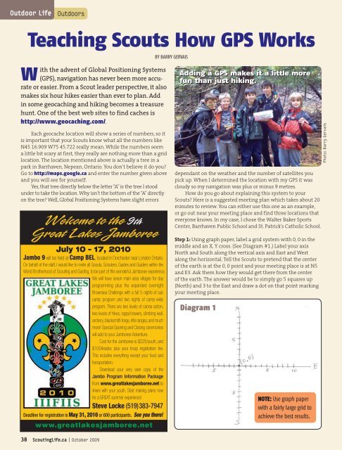
With the advent of Global Positioning Systems<br />
Adding a <strong>GPS</strong> makes it a little more<br />
(<strong>GPS</strong>), navigation has never been more accurate<br />
or easier. From a Scout leader perspective, it also<br />
fun than just hiking.<br />
makes six hour hikes easier than ever to plan. Add<br />
in some geocaching and hiking becomes a treasure<br />
hunt. One of the best web sites to find caches is<br />
http://www.geocaching.com/.<br />
Each geocache location will show a series of numbers, so it<br />
is important that your <strong>Scouts</strong> know what all the numbers like<br />
N45 16.909 W75 45.722 really mean. While the numbers seem<br />
a little bit scary at first, they really are nothing more than a grid<br />
location. The location mentioned above is actually a tree in a<br />
park in Barrhaven, Nepean, Ontario. You don’t believe it do you?<br />
Go to http://maps.google.ca and enter the number given above<br />
and you will see for yourself.<br />
Yes, that tree directly below the letter “A” is the tree I stood<br />
under to take the location. Why isn’t the bottom of the “A” directly<br />
on the tree? Well, Global Positioning Systems have slight errors<br />
dependant on the weather and the number of satellites you<br />
pick up. When I determined the location with my <strong>GPS</strong> it was<br />
cloudy so my navigation was plus or minus 9 metres.<br />
<strong>How</strong> do you go about explaining this system to your<br />
<strong>Scouts</strong>? Here is a suggested meeting plan which takes about 20<br />
minutes to review. You can either use this one as an example,<br />
or go out near your meeting place and find three locations that<br />
everyone knows. In my case, I chose the Walter Baker Sports<br />
Center, Barrhaven Public School and St. Patrick’s Catholic School.<br />
Photo: Barry Gervais<br />
July 10 – 17, 2010<br />
Jambo 9 will be held at Camp BEL, located in Dorchester near London Ontario.<br />
On behalf of the staff, I would like to invite all <strong>Scouts</strong>, Scouters, Guides and Guiders within the<br />
World Brotherhood of Scouting and Guiding, to be part of this wonderful Jamboree experience.<br />
We will have seven main area villages for day<br />
programming plus the expanded overnight<br />
Brownsea Challenge with a full 5 nights of sub<br />
camp program and two nights of camp-wide<br />
program. There are two levels of canoe action,<br />
two levels of hikes, rappel towers, climbing wall,<br />
archery, blacksmith forge, rifle ranges, and much<br />
more! Special Opening and Closing ceremonies<br />
will add to your Jamboree Adventure.<br />
Cost for the Jamboree is $225/youth, and<br />
$100/leader, plus your troop registration fee.<br />
This includes everything except your food and<br />
transportation.<br />
Download your very own copy of the<br />
Jambo Program Information Package<br />
from www.greatlakesjamboree.net to<br />
share with your youth. Start making plans now<br />
for a GREAT summer experience!<br />
Steve Locke (519)383-7947<br />
Deadline for registration is May 31, 2010 or 600 participants. See you there!<br />
Step 1: Using graph paper, label a grid system with 0, 0 in the<br />
middle and an X, Y cross. (See Diagram #1.) Label your axis<br />
North and South along the vertical axis and East and West<br />
along the horizontal. Tell the <strong>Scouts</strong> to pretend that the center<br />
of the earth is at the 0, 0 point and your meeting place is at N5<br />
and E3. Ask them how they would get there from the center<br />
of the earth. The answer would be to simply go 5 squares up<br />
(North) and 3 to the East and draw a dot on that point marking<br />
your meeting place.<br />
Diagram 1<br />
NOTE: Use graph paper<br />
with a fairly large grid to<br />
achieve the best results.<br />
38 ScoutingLife.ca | October 2009
Step 2: Next, pretend to go to the parliament buildings from<br />
your meeting place. Say the parliament buildings are at S2,<br />
W1. Calculated from your meeting place location, the correct<br />
answer should be down 7 (5+2) and over 4 (3+1).<br />
Step 3: Ask them what would happen if the parliament buildings<br />
were actually at S2.5 and W1.5. The answer would be 7.5<br />
and 4.5 respectively. Congratulations; now they understand<br />
how <strong>GPS</strong> works with all those numbers.<br />
Step 4: You may notice that <strong>GPS</strong> uses three sets of numbers<br />
(i.e. N45 16.944). The third sets are simply because the earth<br />
is large and we need to go down to this level to determine<br />
the exact location.<br />
The Challenge<br />
Show the <strong>Scouts</strong> Diagram #2 with the three <strong>GPS</strong> locations<br />
marked on it, followed by the Google picture directly to the right.<br />
Make sure they understand that the diagrams show the same<br />
three locations, the one below right is simply a satellite picture.<br />
Tell them to write down the following number N45 16.909<br />
W 75 45.722. Using the numbers given to them from the three<br />
locations in Diagram #2, navigate using addition and subtraction<br />
to the point above. This is no different than going from N5<br />
E3 to S2 W1 in our training earlier.<br />
Ask them to put an “X” where they think the mystery location<br />
is, and as you already know, it is the tree. After my <strong>Scouts</strong><br />
finished guessing I took my <strong>GPS</strong> and we walked to that location.<br />
They ended up standing under the tree.<br />
Take a Hike<br />
Now that you know how it works, take them out for a geocaching<br />
hike (three or four caches make a great six hour hike).<br />
Treasure hunting makes it a little more fun than just hiking.<br />
For more information on <strong>GPS</strong> hiking, go to the geocaching<br />
website mentioned above.m<br />
— Scouter Barry Gervais enjoys leading the 23rd Nepean <strong>Scouts</strong><br />
on geocaching hikes. Find another <strong>GPS</strong> article in the May 2008<br />
issue of the Leader Magazine.<br />
Diagram 2<br />
(Google Map diagram)<br />
(Satellite Map)<br />
NOTE: A pdf version of<br />
diagram 2 is available<br />
for download at<br />
www.scoutinglife.ca.<br />
ScoutingLife.ca | October 2009 39