Mahtab A. Lodhi Department of Geography ... - UNO Geography
Mahtab A. Lodhi Department of Geography ... - UNO Geography
Mahtab A. Lodhi Department of Geography ... - UNO Geography
Create successful ePaper yourself
Turn your PDF publications into a flip-book with our unique Google optimized e-Paper software.
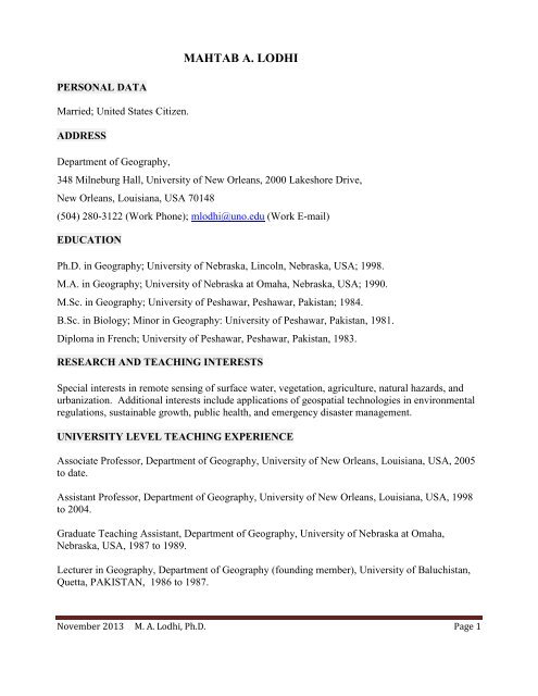
MAHTAB A. LODHI<br />
PERSONAL DATA<br />
Married; United States Citizen.<br />
ADDRESS<br />
<strong>Department</strong> <strong>of</strong> <strong>Geography</strong>,<br />
348 Milneburg Hall, University <strong>of</strong> New Orleans, 2000 Lakeshore Drive,<br />
New Orleans, Louisiana, USA 70148<br />
(504) 280-3122 (Work Phone); mlodhi@uno.edu (Work E-mail)<br />
EDUCATION<br />
Ph.D. in <strong>Geography</strong>; University <strong>of</strong> Nebraska, Lincoln, Nebraska, USA; 1998.<br />
M.A. in <strong>Geography</strong>; University <strong>of</strong> Nebraska at Omaha, Nebraska, USA; 1990.<br />
M.Sc. in <strong>Geography</strong>; University <strong>of</strong> Peshawar, Peshawar, Pakistan; 1984.<br />
B.Sc. in Biology; Minor in <strong>Geography</strong>: University <strong>of</strong> Peshawar, Pakistan, 1981.<br />
Diploma in French; University <strong>of</strong> Peshawar, Peshawar, Pakistan, 1983.<br />
RESEARCH AND TEACHING INTERESTS<br />
Special interests in remote sensing <strong>of</strong> surface water, vegetation, agriculture, natural hazards, and<br />
urbanization. Additional interests include applications <strong>of</strong> geospatial technologies in environmental<br />
regulations, sustainable growth, public health, and emergency disaster management.<br />
UNIVERSITY LEVEL TEACHING EXPERIENCE<br />
Associate Pr<strong>of</strong>essor, <strong>Department</strong> <strong>of</strong> <strong>Geography</strong>, University <strong>of</strong> New Orleans, Louisiana, USA, 2005<br />
to date.<br />
Assistant Pr<strong>of</strong>essor, <strong>Department</strong> <strong>of</strong> <strong>Geography</strong>, University <strong>of</strong> New Orleans, Louisiana, USA, 1998<br />
to 2004.<br />
Graduate Teaching Assistant, <strong>Department</strong> <strong>of</strong> <strong>Geography</strong>, University <strong>of</strong> Nebraska at Omaha,<br />
Nebraska, USA, 1987 to 1989.<br />
Lecturer in <strong>Geography</strong>, <strong>Department</strong> <strong>of</strong> <strong>Geography</strong> (founding member), University <strong>of</strong> Baluchistan,<br />
Quetta, PAKISTAN, 1986 to 1987.<br />
November 2013 M. A. <strong>Lodhi</strong>, Ph.D. Page 1
ACADEMIC ADMINISTRATIVE EXPERIENCE<br />
Graduate Program Advisor, <strong>Department</strong> <strong>of</strong> <strong>Geography</strong>, University <strong>of</strong> New Orleans, Louisiana,<br />
USA, 2001 to 2007.<br />
Member College <strong>of</strong> Liberal Arts Graduate Committee, University <strong>of</strong> New Orleans, Louisiana, USA,<br />
2006 to 2007.<br />
OTHER PROFESSIONAL EXPERIENCE<br />
Research Assistant, Center for Advanced Land Management and Information Technologies<br />
(CALMIT), University <strong>of</strong> Nebraska, Lincoln, Nebraska, USA, 1997 to 1998.<br />
Research Assistant, <strong>Department</strong> <strong>of</strong> Economic Development, State <strong>of</strong> Nebraska, USA, 1996<br />
Research Assistant, Center for Advanced Land Management and Information Technologies<br />
(CALMIT), University <strong>of</strong> Nebraska, Lincoln, Nebraska, USA, 1993 to 1995.<br />
Research Assistant, <strong>Department</strong> <strong>of</strong> <strong>Geography</strong>, University <strong>of</strong> Nebraska, Lincoln, Nebraska, USA,<br />
1992.<br />
Training Coordinator, Omaha Public Power District, Omaha, Nebraska, USA, 1989 to 1991.<br />
TECHNICAL EXPERTISE AND SPECIALIZED SKILLS<br />
Pr<strong>of</strong>essional level expertise in a wide range <strong>of</strong> geospatial information processing and analysis<br />
s<strong>of</strong>tware in various computing environment. Pr<strong>of</strong>essional level expertise in a wide range <strong>of</strong><br />
statistical data processing and analysis s<strong>of</strong>tware. Pr<strong>of</strong>essional level expertise in operating a range <strong>of</strong><br />
spectroscopic equipment and field data collection devices.<br />
THESIS AND DISSERTATION ADVISORY / SUPERVISORY EXPERIENCE<br />
Aram Parrish Lief (Ph.D. Urban and Regional Planning), The New Orleans Urban Heat Island:<br />
Analysis <strong>of</strong> the impact <strong>of</strong> hurricane Katrina on urban vegetation using remotely sensed data,<br />
Expected graduation in Spring 2014, Major Pr<strong>of</strong>essor.<br />
Sara Moore (M.S. Environmental Science), Biophysical Characteristics in Spectral Signature as<br />
Primary Indicators <strong>of</strong> Overall Marsh Health: A Bayou Sauvage National Wildlife Refuge Case<br />
Study, Expected graduation in Spring 2012, Committee Member.<br />
Amanda English (M. A. <strong>Geography</strong>), Imagery-based Spatial Analysis <strong>of</strong> Economic Development in<br />
Selected Counties <strong>of</strong> Mississippi State, Graduated Spring 2011, Major Pr<strong>of</strong>essor.<br />
Rushikesh Kale (M.S. Computer Science), Development <strong>of</strong> Interactive, Hands-on Learning<br />
Experience Using Google MPI, Graduated Spring 2010, Committee Member.<br />
November 2013 M. A. <strong>Lodhi</strong>, Ph.D. Page 2
Lynn Brien (M. A. <strong>Geography</strong>), Privacy and Geospatial Technologies, Graduated Summer 2009,<br />
Major Pr<strong>of</strong>essor.<br />
Jeffrey Varisco (M. A. <strong>Geography</strong>), Multitemporal Imagery Based Analysis <strong>of</strong> Urban Land in St.<br />
Tammany Parish in Conjunction with Socioeconomic Data, Graduated Spring 2009, Major<br />
Pr<strong>of</strong>essor.<br />
Stephanie Lawrence (Ph.D. Urban and Regional Planning), Urban Business Cultural Icons: Their<br />
Application for Understanding Sprawl, Graduated Spring 2008, Co-Chair (with John Wildgen).<br />
Michael Metzger (M. A. <strong>Geography</strong>), Remote sensing for assessing the efficacy <strong>of</strong> Mississippi<br />
freshwater diversion projects, Graduated Fall 2007, Major Pr<strong>of</strong>essor.<br />
Robert Liggio (M.A. <strong>Geography</strong>), Experiments in interactive labeling <strong>of</strong> point spatializations using<br />
TF IDF variations, Graduated Summer 2005, Committee Member.<br />
Kermit Lewis (M. A. <strong>Geography</strong>), Land Cover Change Analysis in Coastal Louisiana, Using Multitemporal<br />
Remotely Sensed Data, Graduated Spring 2002, Major Pr<strong>of</strong>essor.<br />
UNIVERSITY LEVEL COURSES TAUGHT<br />
World Regional <strong>Geography</strong> Series Courses; Environmental <strong>Geography</strong>; Physical <strong>Geography</strong>;<br />
Cultural <strong>Geography</strong>; <strong>Geography</strong> <strong>of</strong> Middle East; <strong>Geography</strong> <strong>of</strong> Asia; <strong>Geography</strong> <strong>of</strong> India and<br />
Pakistan; Introduction to Remote Sensing; Digital Image Processing; Remote Sensing <strong>of</strong> Water<br />
Resources; Field Methods in <strong>Geography</strong>; Seminar Course in Environmental <strong>Geography</strong>; Seminar<br />
Course in Land Use Analysis; Applications <strong>of</strong> Remote Sensing; Geographic Thought and Research<br />
Methods; Process geomorphology; Advanced geomorphology.<br />
PROFESSIONAL HONORS AND AWARDS<br />
Most Dedicated Advisor <strong>of</strong> the Year Award, Student Involvement and Leadership, University <strong>of</strong><br />
New Orleans, Louisiana, Spring 2009.<br />
Outstanding Leadership Award, Student Involvement and Leadership, University <strong>of</strong> New Orleans,<br />
Louisiana, Spring 2008.<br />
MEMBERSHIP IN PROFESSIONAL SOCIETIES<br />
Association <strong>of</strong> American Geographers<br />
American Society for Photogrammetry and Remote Sensing (ASPRS)<br />
Gamma Theta Upsilon International Geographical Honor Society<br />
November 2013 M. A. <strong>Lodhi</strong>, Ph.D. Page 3
ARTICLES IN JOURNALS, BOOKS, ENCYCLOPEDIAS, AND PROCEEDINGS<br />
<strong>Lodhi</strong>, M. A., 2013. Analyzing the Surface Area Variability <strong>of</strong> Lakes in the Sand Hills Region <strong>of</strong><br />
Nebraska, USA. International Journal <strong>of</strong> Applied Earth Observation and Geoinformation (submitted<br />
for peer review)<br />
<strong>Lodhi</strong>, M. A., 2013. Multi-Sensor Imagery Analysis for Mapping and Assessment <strong>of</strong> 12 January<br />
2010 Earthquake-Induced Building Damage in Port-au-Prince, Haiti, International Journal <strong>of</strong><br />
Remote Sensing, Vol. 34, No. 2:pp. 451 – 467 [record first published 10 Sep 2012]<br />
<strong>Lodhi</strong>, M. A., 2011. Earthquake Induced Landslide Mapping in Western Himalayas Using Post<br />
Earthquake Medium Resolution ASTER Imagery. International Journal <strong>of</strong> Remote Sensing, Vol.<br />
32, No. 9: pp. 5331 – 5346.<br />
<strong>Lodhi</strong>, M. A., 2010. Spectral Resolution, in B. Warf (Ed.), Encyclopedia <strong>of</strong> <strong>Geography</strong>, SAGE<br />
Publication Inc. pp. 2676 – 2678.<br />
<strong>Lodhi</strong>, M. A., 2007. Water Quality Monitoring and Assessment Using High Resolution Remotely<br />
Sensed Data. American Academy <strong>of</strong> Sciences, Proceedings <strong>of</strong> the 3 rd International Conference on<br />
Environmental Science and Technology, Houston, Texas, August 6 th – 9 th , 2007: pp. 374 – 379.<br />
<strong>Lodhi</strong>, M. A., 2002. Influence <strong>of</strong> Bright Bottom Depth on Reflectance from Clear and Turbid Water<br />
Bodies. GEOCARTO International, Vol. 17, No. 3: pp. 5 – 15.<br />
<strong>Lodhi</strong>, M. A and Rundquist, D. C., 2001. Spectral Analysis <strong>of</strong> Bottom-Induced Variation in the<br />
Color <strong>of</strong> Sand Hills Lakes, Nebraska, USA. International Journal <strong>of</strong> Remote Sensing, Vol. 22, No.<br />
9: pp. 1665 – 1682.<br />
<strong>Lodhi</strong>, M. A., 1999. Analysis <strong>of</strong> Spectral Signals Emanating from Vegetated and Non-Vegetated<br />
Substrates in Shallow Water Bodies. SPIE International Society for Optical Engineering<br />
Proceedings (Pattern Recognition, Chemometrics, and Imaging for Environmental Monitoring),<br />
Boston, Massachusetts, Sept. 19 th – 22 nd , 1999: pp. 2- 8.<br />
<strong>Lodhi</strong>, M. A., Rundquist, D. C., Han, L., and Kuzila, M. S., 1998. Estimation <strong>of</strong> Suspended<br />
Sediment Concentration in Surface Waters Using Integrated Surface Reflectance. GEOCARTO<br />
International, Vol. 13, No. 2: pp. 11 – 15.<br />
<strong>Lodhi</strong>, M. A., Echavarria, F. R., and Keithley, C., 1998. Using Remote Sensing Data to Monitor<br />
Land Cover Changes near Afghan Refugee Camps in Northern Pakistan. GEOCARTO<br />
International, Vol. 13, No. 1: pp. 33 – 38.<br />
<strong>Lodhi</strong>, M. A., Rundquist, D. C., Han, L., and Kuzila, M. S., 1997. Potential for Remote Sensing <strong>of</strong><br />
Loess Soils Suspended in Surface Waters. Journal <strong>of</strong> the American Water Resources Association,<br />
Vol. 33, No. 1: pp. 111 – 117.<br />
November 2013 M. A. <strong>Lodhi</strong>, Ph.D. Page 4
<strong>Lodhi</strong>, M. A., Echavarria, F. R., and Keithley, C., 1995. An Assessment <strong>of</strong> the impact <strong>of</strong> Afghan<br />
Refugees on Forest Resources <strong>of</strong> Northern Pakistan Using Multitemporal Remotely Sensed Data.<br />
Proceedings ASPRS, Mapping and Environmental Applications <strong>of</strong> GIS Data, Madison, Wisconsin,<br />
September 28 th - 29 th , 1995: pp. 116 – 124.<br />
GRANTS REPORTS<br />
<strong>Lodhi</strong>, M. A., 2010. Gulf <strong>of</strong> Mexico Geospatial Information Support System. A final report<br />
submitted to the Center for Urban Rural Interface Studies, Mississippi State University.<br />
<strong>Lodhi</strong>, M. A., 2009. Smart Growth and Sustainable Development Education Project for St.<br />
Tammany, St. John the Baptist, Tangipahoa, and Washington parishes <strong>of</strong> Louisiana. A final report<br />
submitted to the Center for Urban Rural Interface Studies, Mississippi State University.<br />
WEB-BASED TEACHING TOOLS DEVELOPMENT<br />
Gulf <strong>of</strong> Mexico Geospatial Information Support System. Web-based Interactive tools for<br />
Geospatial Information Visualization and Analysis. (www.gis.uno.edu).<br />
Web-based Interactive Visualization and learning tools for Remote Sensing and GIS<br />
(www.lrssg.uno.edu).<br />
PUBLISHED ABSTRACTS AND BOOK REVIEWS<br />
<strong>Lodhi</strong>, M. A., 2013. Book Review: Environmental Tracking for Public Health Surveillance. Stanley<br />
A. Morain and Amelia M. Budge (Editors). CRC Press: Taylor and Francis Group, London, UK,<br />
2013, xxvii and 419 pp., ISBN 978-0-415-58471-5. Photogrammetric Engineering and Remote<br />
Sensing, Vol. 79, No. 10, 2013: pp 89.<br />
<strong>Lodhi</strong>, M. A., 2012. Book Review: Remote Sensing <strong>of</strong> Urban and Suburban Areas. Tarek Rashed<br />
and Carsten Jürgens (Editors). Springer: Dordrecht Heidelberg London New York, 2010, xii and<br />
352 pp., ISBN 978-1-4020-4371. Photogrammetric Engineering and Remote Sensing, Vol. 78, No.<br />
4, 2012: pp. 294 – 295.<br />
<strong>Lodhi</strong>, M. A., 2012. Catastrophic Slope Failure and Debris Dams in the Karakoram-Himalayas: A<br />
Case <strong>of</strong> Attabad Landslide in Upper Hunza Valley, Northern Pakistan. Association <strong>of</strong> American<br />
Geographers 2012 Annual meeting abstracts, New York, NY, February 24 th – 28 th .<br />
<strong>Lodhi</strong>, M. A., 2011. Catastrophic slope failures and associated disasters and hazards in the<br />
Karakoram-Himalayas. Association <strong>of</strong> American Geographers Annual meeting abstracts, Seattle,<br />
Washington, April 12 th – April 16 th .<br />
<strong>Lodhi</strong>, M. A., 2010. Analysis <strong>of</strong> Spatial Pattern and Trend <strong>of</strong> Urbanization and Associated Land<br />
Cover Changes in Selected Coastal Parishes <strong>of</strong> Louisiana Using Satellite Imagery. Association <strong>of</strong><br />
American Geographers Annual meeting abstracts, Washington, D.C., April 14 th – April 19 th .<br />
November 2013 M. A. <strong>Lodhi</strong>, Ph.D. Page 5
<strong>Lodhi</strong>, M. A., 2008. Web-based Remote Sensing and GIS Interactive Teaching Tools for<br />
Sustainable Development. 4 th International Conference on Environmental Science and Technology<br />
proceedings abstracts, Houston, Texas, July 28 th – July 31 st .<br />
<strong>Lodhi</strong>, M. A., 2008. Remote Sensing <strong>of</strong> Earthquake Induced Damage Assessment in Northern<br />
Pakistan. Association <strong>of</strong> American Geographers Annual meeting abstracts, Boston, Massachusetts,<br />
April 15 th – April 19 th .<br />
Metzger. M. and <strong>Lodhi</strong>, M. A., 2008. Assessing the Effectiveness <strong>of</strong> Louisiana’s Freshwater<br />
Diversion Projects Using Remote Sensing. Association <strong>of</strong> American Geographers Annual meeting,<br />
abstracts, Boston, Massachusetts, April 15 th – April 19 th .<br />
<strong>Lodhi</strong>, M. A., 2007. An Interaction Between Religion and Politics: A Case <strong>of</strong> North Western<br />
Frontier Province <strong>of</strong> Pakistan. Association <strong>of</strong> American Geographers Annual meeting abstracts, San<br />
Francisco, California, April 14 th – April 21 st .<br />
<strong>Lodhi</strong>, M. A., 2002. The impact <strong>of</strong> Varying Depths <strong>of</strong> Vegetated Bottom on Spectral Signals<br />
Upwelling from a Water Body. Association <strong>of</strong> American Geographers Annual meeting abstracts,<br />
Los Angeles, California, March 19 th – 23 rd .<br />
<strong>Lodhi</strong>, M. A. and Shroder, J. F., 1996. Pakistan’s Cross Mountain Communication: Geopolitical and<br />
Economic Implications. Association <strong>of</strong> American Geographers Annual meeting abstracts, Charlotte,<br />
North Carolina, April 9 th - 13 th .<br />
PARTICIPATION AT PROFESSIONAL MEETINGS AND CONFERENCES<br />
Association <strong>of</strong> American Geographers, Annual Meeting, Los Angeles, California, April 10 th – 14 th ,<br />
2013. Paper presented “Analyzing the Long-Term Variability in Lakes Surface Area <strong>of</strong> Sand Hills<br />
Region, USA”.<br />
Association <strong>of</strong> American Geographers, Annual Meeting, New York, NY, February 24 th – 28 th , 2012.<br />
Paper presented “Catastrophic Slope Failure and Debris Dams in the Karakoram-Himalayas: A<br />
Case <strong>of</strong> Attabad Landslide in Upper Hunza Valley, Northern Pakistan”.<br />
27 th Annual Louisiana Remote Sensing and GIS Workshop, New Orleans, Louisiana, May 3 rd – May 5 th ,<br />
2011. Paper presented, “January 2010 Haitian Earthquake – Induced Damage Assessment Using High<br />
Resolution Satellite Imagery’.<br />
27 th Annual Louisiana Remote Sensing and GIS Workshop, New Orleans, Louisiana, May 3 rd – May 5 th ,<br />
2011. Paper presented, “A Preliminary Imagery – Based Assessment <strong>of</strong> Damage Caused by March 2011<br />
Earthquake in Japan”.<br />
November 2013 M. A. <strong>Lodhi</strong>, Ph.D. Page 6
27 th Annual Louisiana Remote Sensing and GIS Workshop, New Orleans, Louisiana, May 3 rd – May 5 th ,<br />
2011. Paper presented (with Allison Kummel and Mark Mitchell), “Urbanization Analysis in Las Vegas,<br />
Nevada”.<br />
Association <strong>of</strong> American Geographers, Annual Meeting, Seattle, Washington, April 12 th – April<br />
16 th , 2011. Paper presented, “Catastrophic slope failures and associated disasters and hazards<br />
in the Karakoram-Himalayas”.<br />
Collaborators Meeting on Smart Growth and Sustainable Development, Center for Urban Rural<br />
Interface Studies, Mississippi State University, Coastal Research & Extension Center, May 17,<br />
2010. Paper presentation on “Gulf <strong>of</strong> Mexico Geospatial Information Support System”.<br />
Association <strong>of</strong> American Geographers, Annual Meeting, Washington, D.C., April 14 th – April 19 th ,<br />
2010. Paper presented, “Analysis <strong>of</strong> Spatial Pattern and Trend <strong>of</strong> Urbanization and Associated Land<br />
Cover Changes in Selected Coastal Parishes <strong>of</strong> Louisiana Using Satellite Imagery”.<br />
ASPRS / MAPPS 2009 Specialty Conference, San Antonio, Texas, November 16 th – 19 th , 2009.<br />
Association <strong>of</strong> American Geographers, Annual Meeting, Las Vegas, Nevada, April 22 nd – April<br />
29 th , 2009.<br />
Pr<strong>of</strong>essional Development Workshop on Learning and Retention, University <strong>of</strong> New Orleans,<br />
October 30 th , 2008.<br />
4 th International Conference on Environmental Science and Technology, Houston, Texas, July 28<br />
through July 31, 2008. Paper presented, “Web – based Remote Sensing and GIS Interactive<br />
Teaching Tools for Sustainable Development”.<br />
Pr<strong>of</strong>essional Development Workshop on Academics and Student Persistence, University <strong>of</strong> New<br />
Orleans, Louisiana, October 31, 2008.<br />
Pr<strong>of</strong>essional Development Workshop on Spectroscopy organized by Ocean Optics and Vernier Inc.<br />
Clear Water, Florida, June 18 th and 19 th , 2008.<br />
Coastal Development Strategies Conference, Biloxi, Mississippi, May 5 th - 6 th , 2008<br />
Association <strong>of</strong> American Geographers, Annual Meeting, Boston, Massachusetts, April 15 th – April<br />
19, 2008. Paper presented, “Remote Sensing <strong>of</strong> Earthquake Induced Damage Assessment in<br />
Northern Pakistan”.<br />
Association <strong>of</strong> American Geographers, Annual Meeting, Boston, Massachusetts, April 15 th – April<br />
19, 2008. Paper presented (co-author with Michael Metzger), “Assessing the Effectiveness <strong>of</strong><br />
Louisiana’s Freshwater Diversion Projects Using Remote Sensing”.<br />
November 2013 M. A. <strong>Lodhi</strong>, Ph.D. Page 7
The Foundation for Career Development Workshop, Southeastern Louisiana University, Hammond,<br />
Louisiana, September 27 th , 2007.<br />
3 rd International Conference on Environmental Science and Technology, Houston, Texas, August<br />
6 th – 9 th , 2007. Paper presented, “Water Quality Monitoring and Assessment Using High Resolution<br />
Remotely Sensed Data”.<br />
Quality Matters Peer Reviewer for Online Course Design Training Workshop, Southeastern<br />
Louisiana University, Hammond, Louisiana, May 31 st , 2007.<br />
Association <strong>of</strong> American Geographers, Annual Meeting, San Francisco, California, April 14 th –<br />
April 21 st , 2007. Paper presented, “An Interaction Between Religion and Politics: A Case <strong>of</strong> North<br />
Western Frontier Province Of Pakistan”.<br />
Teaching in Higher Education Forum, Louisiana State University, Baton Rouge, Louisiana, April<br />
15 th – April 18 th , 2007.<br />
Teaching in Higher Education Forum, Louisiana State University, Baton Rouge, Louisiana, April<br />
24 th , 2006.<br />
NASA InSAR Workshop, Oxnard, California, October 20 th – 22 nd , 2004.<br />
Association <strong>of</strong> American Geographers, Annual Meeting, Los Angeles, California, March 19 th – 23 rd ,<br />
2002. Paper presented, “The impact <strong>of</strong> Varying Depths <strong>of</strong> Vegetated Bottom on Spectral Signals<br />
Upwelling from a Water Body.”<br />
SPIE - International Society for Optical Engineering conference on Pattern Recognition,<br />
Chemometrics, and Imaging for Environmental Monitoring, Boston, Massachusetts, Sept 19 th - 22 nd ,<br />
1999. Paper presented, “Analysis <strong>of</strong> Spectral Signals Emanating from Vegetated and Non-<br />
Vegetated Substrate in Shallow Water Bodies.”<br />
American Society for Photogrammetry and Remote Sensing, Annual Conference, Portland, Oregon,<br />
May 17 th - 21 st , 1999. Paper presented, “Impact <strong>of</strong> Varying Depths <strong>of</strong> Vegetated Bottom on Spectral<br />
Signals Upwelling from a Water Body.”<br />
American Water Resources Association, 34 th Annual Conference and Symposium Applications <strong>of</strong><br />
Water Use Information, Point Clear, Alabama, November 16 th - 19 th , 1998. Paper presented,<br />
“Analysis <strong>of</strong> Bottom Influence on Upwelling Spectral Signals in Shallow Lakes.”<br />
Association <strong>of</strong> American Geographers, Annual Meeting, Charlotte, North Carolina, April 9 th - 13 th ,<br />
1996. Paper presented (with John F. Shroder Jr.,), “Pakistan’s Cross Mountain Communication:<br />
Geopolitical and Economic Implications.”<br />
American Society for Photogrammetry and Remote Sensing, Madison, Wisconsin, September 28 th –<br />
29 th , 1995. Paper presented, “An Assessment <strong>of</strong> the Impact <strong>of</strong> Afghan Refugees on Forest<br />
November 2013 M. A. <strong>Lodhi</strong>, Ph.D. Page 8
Resources <strong>of</strong> Northern Pakistan Using Multi-temporal Remotely-sensed data.”<br />
CONFERENCES SESSION CHAIR AND SERVICE ON SCIENTIFIC COMMITTEES<br />
Association <strong>of</strong> American Geographers, Annual Meeting, Boston, Massachusetts, April 15 th – April<br />
19 th , 2008. Session Chair: Hazards: Mapping and Risk Assessment Using GIS.<br />
Scientific Committee Member, 3 rd International Conference on Environmental Science and<br />
Technology (ICEST 2007), Houston, Texas, August 6 th – August 9 th , 2007.<br />
3 rd International Conference on Environmental Science and Technology (ICEST 2007), Houston,<br />
Texas, August 6 th – August 9 th , 2007. Session Chair: Urban Ecosystems.<br />
Association <strong>of</strong> American Geographers, Annual Meeting, San Francisco, California, April 14 th –<br />
April 21 st , 2007. Session Chair: India and Pakistan.<br />
American Society for Photogrammetry and Remote Sensing (ASPRS), Annual Conference,<br />
Portland, Oregon, May 17 th - 21 st , 1999. Session Chair: Water Resources Management.<br />
American Water Resources Association, 34 th Annual Conference and Symposium Applications <strong>of</strong><br />
Water Use Information, Point Clear, Alabama, November 16 th - 19 th , 1999: Session Chair.<br />
INVITED UNPUBLISHED LECTURES<br />
Catastrophic Slope Failures and Associated Hazards in Karakoram. Seminar Series Speaker,<br />
<strong>Department</strong> <strong>of</strong> Physics, University <strong>of</strong> New Orleans, Louisiana, March 2010.<br />
Haiti Earthquake Damage Assessment Using High Resolution Satellite Imagery. Seminar Series<br />
Speaker, <strong>Department</strong> <strong>of</strong> Physics, University <strong>of</strong> New Orleans, Louisiana, October 2010.<br />
Lectures on remote sensing for land use land cover analysis. University <strong>of</strong> Veracruz, Mexico.<br />
November 2002. (University <strong>of</strong> New Orleans and University <strong>of</strong> Veracruz collaborative program).<br />
RESEARCH GRANTS AND AWARDS<br />
<strong>Lodhi</strong>, M. A., Gulf <strong>of</strong> Mexico Coastal Geospatial Information Support System (CGISS). National<br />
Oceanic and Atmospheric Administration / Mississippi State University, Center for Urban Rural<br />
Interface Studies, $78,000, January 2009 December 2009.<br />
<strong>Lodhi</strong>, M. A., Smart Growth Education Project for Tangipahoa, Washington, St. John and St.<br />
Tammany Parishes, National Oceanic and Atmospheric Administration / Mississippi State<br />
University, Center for Urban Rural Interface Studies, $50,000, August 2007–Summer 2008.<br />
November 2013 M. A. <strong>Lodhi</strong>, Ph.D. Page 9
Johnson M. L., <strong>Lodhi</strong>, M. A., and Clawson, D., Using Satellite Imagery to Analyze Agricultural<br />
Land Use Changes Near Veracruz, Mexico, NASA Geospatial Education Pilot Study for the Gulf <strong>of</strong><br />
Mexico Accord, $25,000, August 2001 – May 2003.<br />
<strong>Lodhi</strong>, M. A., Spectroscopy Applications for Water Quality, Innovations in Educational<br />
Spectroscopy, Ocean Optic, Inc, $3,199, May 2000.<br />
<strong>Lodhi</strong>, M. A., Estimation <strong>of</strong> Ecological Impact <strong>of</strong> Freshwater Diversion Projects in Southeastern<br />
Louisiana Using Multi-temporal Remotely Sensed Data, University <strong>of</strong> New Orleans Summer<br />
Research Award, $4,132, May 2002 – July 2002.<br />
<strong>Lodhi</strong>, M. A., International Society for Optical Engineering, Symposium Registration fee Waiver<br />
($650), September 1999.<br />
<strong>Lodhi</strong>, M. A., Landslide Mapping in the Himalayas, Graduate Research Award, <strong>Department</strong> <strong>of</strong><br />
<strong>Geography</strong>, University <strong>of</strong> Nebraska at Omaha, $10,800, January 1992 – December 1992.<br />
<strong>Lodhi</strong>, M. A., Quaternary Geomorphology <strong>of</strong> Meadville Landslide, M. A. Thesis Research Award,<br />
University Committee on Research, University <strong>of</strong> Nebraska at Omaha, $250, August 1988 – May<br />
1989.<br />
SERVICE TO SCHOLARLY JOURNALS AND PROFESSIONAL ORGANIZATIONS<br />
Reviewer International Journal <strong>of</strong> Remote Sensing.<br />
Reviewer Photogrammetric Engineering and Remote Sensing.<br />
Reviewer Southeastern Geographer.<br />
Reviewer Science <strong>of</strong> the Total Environment.<br />
Reviewer National Science Foundation<br />
Reviewer Remote Sensing<br />
ACADEMIC AND COMMUNITY SERVICE<br />
Advisor to Pakistan Students Association at the University <strong>of</strong> New Orleans, Louisiana, 2001 to date.<br />
Region I Science Olympiad <strong>Department</strong>al Coordinator, University <strong>of</strong> New Orleans, 2001 to 2005.<br />
Proctor Greater New Orleans District Rally, University <strong>of</strong> New Orleans, 1999 to 2001.<br />
November 2013 M. A. <strong>Lodhi</strong>, Ph.D. Page 10


