Souza II - Contra Costa County
Souza II - Contra Costa County
Souza II - Contra Costa County

You also want an ePaper? Increase the reach of your titles
YUMPU automatically turns print PDFs into web optimized ePapers that Google loves.
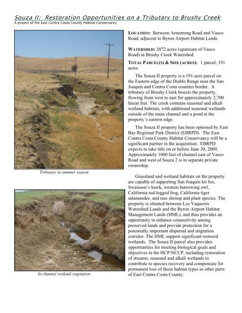
<strong>Souza</strong> <strong>II</strong>: Restoration Opportunities on a Tributary to Brushy Creek<br />
A project of the East <strong>Contra</strong> <strong>Costa</strong> <strong>County</strong> Habitat Conservancy<br />
LOCATION: Between Armstrong Road and Vasco<br />
Road, adjacent to Byron Airport Habitat Lands<br />
Tributary in summer season<br />
In channel wetland vegetation<br />
WATERSHED: 2072 acres (upstream of Vasco<br />
Road) in Brushy Creek Watershed<br />
TOTAL PARCEL(S) & SIZE (ACRES): 1 parcel; 191<br />
acres<br />
The <strong>Souza</strong> <strong>II</strong> property is a 191-acre parcel on<br />
the Eastern edge of the Diablo Range near the San<br />
Joaquin and <strong>Contra</strong> <strong>Costa</strong> counties border. A<br />
tributary of Brushy Creek bisects the property,<br />
flowing from west to east for approximately 2,700<br />
linear feet. The creek contains seasonal and alkali<br />
wetland habitats, with additional seasonal wetlands<br />
outside of the main channel and a pond at the<br />
property’s eastern edge.<br />
The <strong>Souza</strong> <strong>II</strong> property has been optioned by East<br />
Bay Regional Park District (EBRPD). The East<br />
<strong>Contra</strong> <strong>Costa</strong> <strong>County</strong> Habitat Conservancy will be a<br />
significant partner in the acquisition. EBRPD<br />
expects to take title on or before June 30, 2009.<br />
Approximately 1000 feet of channel east of Vasco<br />
Road and west of <strong>Souza</strong> 2 is in separate private<br />
ownership.<br />
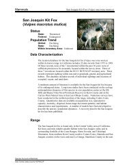
Grassland and wetland habitats on the property<br />
are capable of supporting San Joaquin kit fox,<br />
Swainson’s hawk, western burrowing owl,<br />
California red-legged frog, California tiger<br />
salamander, and rare shrimp and plant species. The<br />
property is situated between Los Vaqueros<br />
Watershed Lands and the Byron Airport Habitat<br />
Management Lands (HML), and thus provides an<br />
opportunity to enhance connectivity among<br />
preserved lands and provide protection for a<br />
potentially important dispersal and migration<br />
corridor. The HML support significant restored<br />
wetlands. The <strong>Souza</strong> <strong>II</strong> parcel also provides<br />
opportunities for meeting biological goals and<br />
objectives in the HCP/NCCP, including restoration<br />
of streams, seasonal and alkali wetlands to<br />
contribute to species recovery and compensate for<br />
permanent loss of those habitat types in other parts<br />
of East <strong>Contra</strong> <strong>Costa</strong> <strong>County</strong>.
<strong>Souza</strong> <strong>II</strong>: Restoration Opportunities on a Tributary to Brushy Creek<br />
A project of the East <strong>Contra</strong> <strong>Costa</strong> <strong>County</strong> Habitat Conservancy<br />
Thistle infestation on northwest potion of parcel<br />
EXISTING WETLAND TYPE(S), DESCRIPTION, AND<br />
ACRES: The tributary to Brushy Creek is a linear<br />
and incised channel throughout the parcel. The<br />
banks are mostly unvegetated or vegetated with<br />
non-native plant species, with some patches of salt<br />
grass (Distichlis spicata). Bank instability is likely<br />
due to over-grazing and high velocity runoff from<br />
artificial channels draining Vasco road, both of<br />
which exacerbate erosion. The creek supports<br />
some in-channel wetland vegetation on sediment<br />
wedges along the channel bottom. Wetland areas<br />
adjacent to the tributary are heavily grazed and are<br />
of low to moderate quality. Other wetlands are<br />
formed behind man-made berms with no fencing to<br />
exclude grazing animals.<br />
INITIAL THOUGHTS ON POTENTIAL RESTORATION PROJECT<br />
• The intent is to construct a restoration project during 2009 to stay ahead of restoration requirements.<br />
• Phasing could be considered for financial/logistical reasons.<br />
• Constraints include a power line near channel and a severe milk thistle infestation on neighboring hills.<br />
• Important for restoration not to significantly harm covered terrestrial species such as SJKF.<br />
INITIAL THOUGHTS ON POTENTIAL RESTORATION GOALS<br />
• Benefit covered species<br />
• Address HCP’s most challenging restoration requirements, such as those for streams, seasonal/alkali<br />
wetlands and fairy shrimp to greatest extent possible (e.g. maximize restored acreages.)<br />
• Be cost effective<br />
• Restore hydrologic functions<br />
• Provide significant aesthetic improvement. Property is very visible from Vasco Road and will be public<br />
parkland. A dramatic beautification would be wonderful.
preliminary findings:<br />
HISTORICAL ECOLOGY OF SOUZA <strong>II</strong> PROPERTY<br />
detail of brushy creek area from california geological survey<br />
“topographical map of central california”, whitney and hoffman, 1873<br />
A Technical Memoradum to <strong>Contra</strong> <strong>Costa</strong> <strong>County</strong><br />
Robin Grossinger<br />
Ruth Askevold<br />
San Francisco Estuary Institute<br />
August 2008
introduction<br />
The <strong>Souza</strong> <strong>II</strong> property is approximately 190 acres recently<br />
purchased for restoration purposes by <strong>Contra</strong> <strong>Costa</strong> <strong>County</strong>.<br />
Currently a tributary of Brushy Creek runs from west to east<br />
across the property in a deeply incised and straight channel. The<br />
tributary connects with Brushy Creek about a mile beyond the<br />
east edge of the <strong>Souza</strong> <strong>II</strong> property (see Fig. 1).<br />
scale: 1:96,000<br />
Figure 1. <strong>Souza</strong> <strong>II</strong> property (center of map, outlined in orange) with<br />
contemporary stream network depicted on 2005 imagery.<br />
This memorandum was produced to provide technical support<br />
for <strong>Contra</strong> <strong>Costa</strong> <strong>County</strong>. It presents early findings for the<br />
<strong>Souza</strong> <strong>II</strong> project area to inform the development of restoration<br />
strategies for the area. The technical memorandum describes<br />
some of the historical documents that have been collected for<br />
the Brushy Creek area, focusing on the tributary to Brushy<br />
Creek that currently bisects the property from west to east. This<br />
memorandum is for use by <strong>Contra</strong> <strong>Costa</strong> <strong>County</strong> and the county’s<br />
partners, and not for general distribution. It is assumed that the<br />
audience is familiar with the contemporary geographic setting<br />
of the study area.<br />
The preliminary evidence assembled here suggests that the project area was historically a diffuse, seasonally flooded<br />
drainage system with alkali wetlands, perhaps vernal pool/swale features, and a discontinuous channel. It appears that this<br />
system was converted to a relatively straight artificial channel in the early 20th century, presumably to improve drainage<br />
characteristics.<br />
preliminary status<br />
It should be recognized that this assessment is preliminary to the Eastern <strong>Contra</strong> <strong>Costa</strong> Historical Ecology Study report which<br />
is in progress. This report, which will incorporate additional data, analysis, and review, will describe the historical (i.e., prior<br />
to substantial Euro-American modification) characteristics of Eastern <strong>Contra</strong> <strong>Costa</strong> <strong>County</strong>. The scope of this document,<br />
therefore, will be limited to a description of the documents that have been found for this area. This information could provide<br />
a conceptual framework for restoration planning but should be considered preliminary.<br />
data sources<br />
The sources presented here include several historical maps showing possible stream configurations (1853 to<br />
contemporary); General Land Office survey data describing the east side of the property (1862); historical botanical<br />
specimen locations and descriptions in the area (prior to 1915); a USDA soil map (1933/39); and a mosaic of aerial<br />
photographs showing stream alignment (1939). These documents present a preliminary illustration of landscape<br />
characteristics before post-World War <strong>II</strong> development.<br />
review of individual data sources<br />
Historical maps indicating channel configuration<br />
The tributary to Brushy Creek on the <strong>Souza</strong> <strong>II</strong> property is currently a deeply incised and relatively straight channel,<br />
connecting to the main of Brushy Creek (see Fig 1). Several of the earliest historical maps show the tributary as<br />
discontinuous, with the defined channel ending approximately 1/2 mile to the southwest of the property and reappearing<br />
Page 1 • August 2008
mid-way across the property. Later maps show these reaches connected with a straight, presumably artificial channel. The<br />
following maps illustrate this pattern.<br />
The maps that show the tributary not connecting include:<br />
Fig. 2: Los Meganos confirmation survey, U.S. Surveyor’s Office, 1853<br />
Fig. 3: Topographical Map of Central California (California Geological Survey), Whitney and Hoffman, 1873<br />
Fig. 4: Official Map of <strong>Contra</strong> <strong>Costa</strong> <strong>County</strong>, McMahon, 1908<br />
Fig. 5: Map of <strong>Contra</strong> <strong>Costa</strong> and Alameda Counties, Weber 1913<br />
Fig. 6: Official Map of <strong>Contra</strong> <strong>Costa</strong> <strong>County</strong>, Arnold & Glass, 1914<br />
By 1916, the U.S. Geological Survey map shows the tributary connecting across the <strong>Souza</strong> <strong>II</strong> property (Fig. 7).<br />
Figure 2. This detail from an1853 map of Los Meganos appears to be a copy made by the<br />
U.S. Surveyor General’s Office of the 1853 original diseño (land grant map), probably for<br />
the confirmation hearings for the land grant. The map depicts a channel and pond on the<br />
east side of the grant. The channel, marked “Salt water”, ends about one-half a mile above<br />
a body of water, marked “Pond” on this map. The same feature is marked “Salt Pond” on the<br />
original map. Once georeferenced, this channel falls in the same location as the tributary<br />
to Brushy Creek; however further investigation is required to confirm the location.<br />
The newly established township and range lines are depicted on each map, and were used<br />
to help align the map during georeferencing in the GIS. Measurement between persistent<br />
features in the georeferenced diseño and the contemporary landscape varies, but overall<br />
was remarkably good for such an early map. For example, Briones, Deer, and Horse valleys<br />
correspond to the location of the same valleys on a contemporary map, and the lower<br />
portion of Marsh Creek agrees in general trend and direction. However, without further<br />
investigation, it is difficult to say with certainty the channel portrayed on the land grant<br />
map is the tributary to Brushy Creek.<br />
scale: 1:96,000<br />
Figure 3. However, this 1873 map by Hoffmann and Whitney of the California Geological<br />
Survey shows the tributary to Brushy Creek quite clearly, and depicts the channel as<br />
stopping west of the <strong>Souza</strong> <strong>II</strong> boundary (a) and reappearing to the east (b).<br />
This small scale (1:380,000) yet detailed map, entitled “Topographical Map of Central<br />
California Together With a Part of Nevada” was part of a statewide surveying and mapping<br />
b<br />
effort by the California Geological Survey.<br />
a<br />
scale: 1:96,000<br />
Page 2 • August 2008
Figure 4. The “Official Map of <strong>Contra</strong> <strong>Costa</strong> <strong>County</strong> California” from 1908 was “compiled<br />
from private surveys and official records” by surveyor T.A. McMahon. The portion shown<br />
to the left indicates the tributary of Brushy Creek is discontinuous for1500 meters, ending<br />
close to the eastern edge of the Los Vaqueros land grant (a), and reappearing again in the<br />
NE of section 21, on the <strong>Souza</strong> <strong>II</strong> property (b).<br />
b<br />
a<br />
scale: 1:96,000<br />
Figure 5. In a privately published map of <strong>Contra</strong> <strong>Costa</strong> and Alameda counties by C.F. Weber<br />
and Co. in 1913, the tributary of Bushy Creek also ends close to the eastern edge of the Los<br />
Vaqueros land grant boundary (a). On this particular map, the channel does not reappear<br />
before the Brushy Creek mainstem (though it’s unclear if that was omitted due to the large<br />
township and range numbers).<br />
a<br />
scale: 1:96,000<br />
Figure 6. In 1914, a new edition of the “Official Map of <strong>Contra</strong> <strong>Costa</strong> <strong>County</strong> California” was<br />
published. In this version by Arnold and Glass, the tributary to Brushy Creek is only shown<br />
as a channel starting within the <strong>Souza</strong> <strong>II</strong> property (b), and not on the eastern side of Los<br />
Vaqueros land grant.<br />
b<br />
scale: 1:96,000<br />
Page 3 • August 2008
Figure 7. The 1916 USGS quadrangle of Byron (15 minute, 1:63500 scale) shows the<br />
tributary continuous across the <strong>Souza</strong> <strong>II</strong> property. The quadrangle indicates the channel<br />
now runs closely parallel to a dirt road through the <strong>Souza</strong> <strong>II</strong> property in a straight line.<br />
scale: 1:96,000<br />
General Land Office PLS notes<br />
E.H. Dyer surveyed the eastern boundary of Township 1S, Range 3E, Section 21 (the eastern edge of the <strong>Souza</strong> <strong>II</strong> boundary)<br />
for the General Land Office Survey (GLO) in June 1862. In his survey notes, he records “A brook now dry, runs northeast” as<br />
he crosses the tributary at the section line, indicating the bed of the creek appeared to have carried water at some point.<br />
The western edge of Section 21 was only surveyed to establish the eastern boundary of Los Vaqueros land grant, and does<br />
not contain notes about any fluvial features.<br />
Figure 8. Dyer noted in the 1863 GLO survey as he crossed the tributary to Brushy Creek<br />
that “a brook now dry, runs northeast”. The survey notes also indicate that there were no<br />
trees in the vicinity (indicated here by black and white circles).<br />
A brook now dry,<br />
runs northeast.<br />
scale: 1:48,000<br />
Page 4 • August 2008
Historical plant locations and descriptions (1884 to 1914)<br />
The Consortium of California Herbaria has assembled plant data collected by a variety of institutions. When possible, these<br />
institutions have assigned geographic locations indicating where the specimens were collected, and have provided that<br />
spatial location as part of the specimen data. These locations can be very generalized (i.e. even though specific longitude<br />
and latitude coordinates are assigned to the specimen, the collector may have indicated only a very general location, for<br />
example, the location of the species may have been a vague as the “Byron quadrangle”).<br />
Some of the early plants within a two-mile radius of the <strong>Souza</strong> <strong>II</strong> property are noted below (Table 1).<br />
Table 1. Data provided by the participants of the Consortium of California Herbaria (ucjeps.berkeley.edu/consortium/) and Calfora.<br />
Taxon Name notes from Calflora Common name Date Collected<br />
Lasthenia fremontii<br />
native; wetland-riparian; occurs almost always under natural<br />
conditions in wetlands [U.S. Fish & Wildlife Svc.]<br />
goldfields Apr 1 1884<br />
Centromadia pungens subsp. pungens<br />
native; annual herb; wetland-riparian; equally likely to occur in<br />
wetlands or non wetlands [U.S. Fish & Wildlife Svc.]<br />
tarweed May 23 1886<br />
Tropidocarpum capparideum native; rare species; valley grassland (extinct) caper-fruited<br />
tropidocarpum<br />
Mar 24 1888<br />
Chlorogalum pomeridianum var.<br />
pomeridianum<br />
native; perennial herb; valley grassland amole; soap plant May 23 1889<br />
Trifolium depauperatum var. depauperatum<br />
native; annual herb; valley grassland, mixed evergreen forest; wetlandriparian;<br />
equally likely to occur in wetlands or non wetlands [U.S. Fish<br />
& Wildlife Svc.]<br />
clover Mar 23 1889<br />
Lepidium dictyotum<br />
native; annual herb; valley grassland, Alkali Sink, wetland-riparian;<br />
occurs almost always under natural conditions in wetlands [U.S. Fish &<br />
Wildlife Svc.]<br />
pepperwort;<br />
peppergras; one<br />
variant called<br />
alkali pepperweed<br />
May 1898<br />
Allenrolfea occidentalis<br />
native; shrub; Alkali sink, wetland-riparian; usually occurs in wetlands,<br />
but occasionally found in non wetlands [U.S. Fish & Wildlife Svc.]<br />
iodine bush May 1898<br />
Ruppia cirrhosa<br />
native; aquatic perennial herb; coastal salt marsh, freshwater wetlands,<br />
wetland-riparian; occurs almost always under natural conditions in<br />
wetlands [U.S. Fish & Wildlife Svc.]<br />
ditch grass Sep 1899<br />
Polygonum aviculare subsp. aviculare<br />
not native; annual or perennial herb; also wetland-riparian; occurs<br />
almost always under natural conditions in wetlands [U.S. Fish & Wildlife<br />
Svc.]<br />
water knotweed Sept. 1899<br />
Suaeda moquinii<br />
native; perennial herb; Coastal Salt Marsh, Coastal Sage Scrub,<br />
Sagebrush Scrub, Creosote Bush Scrub, Alkali Sink, wetland-riparian;<br />
equally likely to occur in wetlands or non wetlands [U.S. Fish & Wildlife<br />
Svc.]<br />
inkweed Sep 1899<br />
Salicornia virginica<br />
native; perennial herb; coastal salt marsh, wetland-riparian; occurs<br />
almost always under natural conditions in wetlands [U.S. Fish & Wildlife<br />
Svc.]<br />
pickleweed Sep 1899<br />
Heterodraba unilateralis native; annual herb; valley grassland, foothill woodland; slopes ladiestongue<br />
mustard<br />
Mar 14 1914<br />
Phacelia tanacetifolia native; annual herb; many plant communities unknown Mar 14 1914<br />
Lasthenia ferrisiae<br />
native; rare and endangered; annual herb; valley grassland, wetlandripariain;<br />
occurs almost always under natural conditions in wetlands<br />
[U.S. Fish & Wildlife Svc.]<br />
goldfields Mar 14 1914<br />
Page 5 • August 2008
USDA Soil Survey, 1933 (issued 1939)<br />
The historical USDA soil survey is consistent with the modern survey, showing alkali soils with low permeability. The<br />
straight and incised tributary to Brushy Creek on the <strong>Souza</strong> <strong>II</strong> property is on poorly drained Solano silty clay, in an alkali<br />
affected area. Solano silty clay is described as having a “hummocky microrelief”, suggesting vernal pool conditions.<br />
Figure 9: The 1933/39 USDA soil map shows three soil types on the property:<br />
So: Solano silty clay, coinciding with area of “alkali affected” in red (“hummocky<br />
microrelief”; poor drainage; alkaline, especially subsoil; high salt content)<br />
Al: Altamont clay loam (easily cultivated, retentive of moisture)<br />
Hl: Herdlyn loam (poor in organic material; hard and baked when dry)<br />
Solano silty clay<br />
Altamont clay loam<br />
Herdlyn loam<br />
Alkali affected<br />
scale: 1:96,000<br />
Historical aerial photography from 1939<br />
The historical aerial photographs show a straight channel through most of the property, but also shows multiple shallow<br />
channels, possibly indicating seasonally wet swales or sloughs. Note area of natural appearing channel on east edge of<br />
property (Fig. 10).<br />
Figure 10: A mosaic of 1939 aerial photographs, shown against contemporary imagery.<br />
channel appearing natural<br />
straight channel<br />
scale: 1:24,000<br />
Page 6 • August 2008
discussion<br />
The sources presented here suggest that the Brushy Creek tributary had a distinctly different channel/wetland morphology<br />
than the current straight and deeply incised connection across the <strong>Souza</strong> <strong>II</strong> property (see Fig. 1).<br />
Maps prior to 1916 show the channel as discontinuous. It is possible these sources are not independent, but rather are<br />
compiled and therefore may repeat information rather than be independent confirmation. For example, the second “official”<br />
map of the county (Arnold and Glass, 1914; see Fig. 6) likely built on the first (McMahon, 1908; see Fig. 4), so the gap in the<br />
creek’s channel indicated on both maps is not necessarily evidence of the creek being surveyed on two separate occasions.<br />
The privately published map in 1913 may have been compiled from the published McMahon county map as well. However,<br />
the 1873 California Geological Survey clearly depicts the creek as being discontinuous (Whitney and Hoffman, 1873; see<br />
Fig. 3). Additionally, if this depiction of the tributary to Brushy Creek as discontinuous was incorrect, it is likely it would<br />
have been corrected on the second map of the county in 1914.<br />
The General Land Office survey notes indicate there was a natural creek channel on the east side of the property in 1862.<br />
This is consistent with the evidence found on the historical maps described above, as each map source (except for Fig. 5)<br />
shows the channel in evidence on the east side of the <strong>Souza</strong> <strong>II</strong> property. This also appears to be evident in the historical and<br />
contemporary aerial photographs.<br />
The list of plant species collected in the area before 1915 indicates the presence of wetland-riparian plants, though it is not<br />
clear if this was simply the preference of the collector. Also, the these are not necessarily plants found on the property but<br />
simply a list of plants in the vicinity. The presence of plants that occur in alkali sinks is consistent with the alkali soils<br />
found in the area.<br />
The tributary of Brushy Creek currently crosses the property on the area of historical Solano silty clay and an alkali<br />
affected area. This could indicate a the presence of an alkali meadow/wetland. The land grant map from 1853 confirms a<br />
channel with “salt water” as well as a salty pond in the area.<br />
The 1939 aerial photographs show multiple shallow channels as well as a straight ditch through the project area. Remnants<br />
of at least one of these shallow channels are still visible.<br />
Despite some uncertainty among individual documents, an array of historical evidence suggests that the project area was<br />
a diffuse, seasonally flooded drainage system with no well-defined channel across most of the property. Soils and botanical<br />
evidence suggest alkali wetland and vernal pool ecology. The site probably had a high degree of topographic variability with<br />
shallow channels or sloughs and perhaps larger bodies of persistent surface water (e.g. 1853 Los Meganos land grant map).<br />
Page 7 • August 2008