INTRODUCTION TO MARINE GEOLOGY - The Cyprus Institute
INTRODUCTION TO MARINE GEOLOGY - The Cyprus Institute
INTRODUCTION TO MARINE GEOLOGY - The Cyprus Institute

Create successful ePaper yourself
Turn your PDF publications into a flip-book with our unique Google optimized e-Paper software.
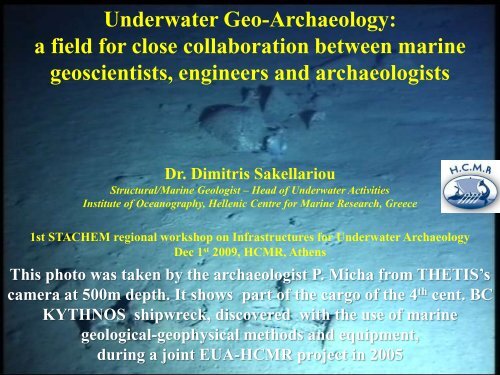
Underwater Geo-Archaeology:<br />
a field for close collaboration between marine<br />
geoscientists, engineers and archaeologists<br />
Dr. Dimitris Sakellariou<br />
Structural/Marine Geologist – Head of Underwater Activities<br />
<strong>Institute</strong> of Oceanography, Hellenic Centre for Marine Research, Greece<br />
1st STACHEM regional workshop on Infrastructures for Underwater Archaeology<br />
Dec 1 st 2009, HCMR, Athens<br />
This photo was taken by the archaeologist P. Micha from THETIS’s<br />
camera at 500m depth. It shows part of the cargo of the 4 th cent. BC<br />
KYTHNOS shipwreck, discovered with the use of marine<br />
geological-geophysical methods and equipment,<br />
during a joint EUA-HCMR project in 2005
Marine Geosciences in Underwater Archaeology<br />
Active Geology = relief forming process<br />
Seafloor morphology<br />
Faults, volcanoes, landslides<br />
Sedimentary processes<br />
Site Formation<br />
Site formation processes control the preservation of<br />
submerged antiquities and the possibility to be<br />
detected by conventional techniques
Volcanic submarine deposits<br />
>50m<br />
AirGun 10 c.i. seismic profile
Sedimentary processes - Sedimentation rate<br />
3.5kHz sub-bottom profile
VERTICAL TEC<strong>TO</strong>NIC MOVEMENTS<br />
Submerged ruins of Ancient Tifa at the<br />
northern coast of Corinth Gulf
DELTA PROGRADATION<br />
<strong>The</strong> shipsheds of Ancient Oiniadai, Acheloos Delta
Marine geo-scientific methods & techniques<br />
Multi beam:<br />
Swath bathymetry<br />
Side scan sonar:<br />
seafloor acoustic<br />
imaging<br />
Subbottom profiler:<br />
sub-seafloor structure<br />
Magnetometer:<br />
prospecting of metallic<br />
objects<br />
Integration<br />
of data sets<br />
Experience
Marine technology / Underwater vehicles<br />
ROVs:<br />
Remotely operated<br />
vehicles<br />
HOVs:<br />
Human occupied<br />
vehicles<br />
AUVs:<br />
Autonomous<br />
Operated vehicles<br />
Sensors payload
HOV THETIS<br />
2-person, 610m depth<br />
ROV MaxRover<br />
(2000m)<br />
ROV Achilles<br />
1000m depth<br />
AUV Seabed
Real-time precision navigation
High definition camera for photo-mosaicing
Simultaneous HOV <strong>The</strong>tis – AUV Seabed dives
Fast coverage of large survey areas<br />
15 days survey time<br />
> 100 sq. km covered with side scan<br />
sonar<br />
> 300 km subbottom profiles<br />
> 50 hours of dives at depths between<br />
600-1100 m
DISCOVERY<br />
KYTHNOS-2005<br />
500m
HIGH RESOLUTION AUV MAPPING<br />
AUV track lines<br />
Microbathymetry of the wreck site
AUV PHO<strong>TO</strong>GRAMMETRY
RECOVERY OF ARTEFACTS
Underwater Geo-Archaeology:<br />
A very demanding scientific field<br />
It requires high technology<br />
It is “costly”<br />
It requires collaborative spirit (= open minded people)<br />
and willing to bridge the world of archaeologists<br />
with the one of natural scientists and engineers<br />
A very promising scientific field<br />
extends the depth limits further deep<br />
provides higher accuracy / resolution<br />
minimizes the time of field work<br />
supports and enriches underwater archaeological research<br />
with advanced techniques
<strong>The</strong> EUA – HCMR joint work is being considered as the<br />
most successful example of collaboration between<br />
archaeological and marine research institutions worldwide<br />
<strong>The</strong> collaboration<br />
between HCMR<br />
and the Ephorate for<br />
Underwater Antiquities,<br />
started in 2000<br />
Joint projects with<br />
WHOI, INA/Texas<br />
A&M, MIT<br />
More than 20 joint<br />
cruises devoted to<br />
Underwater Archaeology<br />
Over 30 shipwrecks<br />
discovered / mapped at<br />
depths up to 700m
European Commission, 7 th Framework Program<br />
Europe’s submerged Pre-History<br />
“PROJECT DEUKALION”<br />
To integrate the skills of archaeological and oceanographic agencies with<br />
the use of modern offshore and laboratory technology to advance the<br />
understanding of the prehistoric archaeology and terrestrial landscape of<br />
the European continental shelf since the last ice age / low sea-level stand<br />
(-120m)(Paleolithic – Mesolithic era)<br />
North Sea<br />
English channel<br />
Adriatic Sea<br />
Black Sea<br />
Gibraltar strait<br />
Sicily strait<br />
Aegean Sea
COST Action TD0902<br />
“Submerged Prehistoric Landscapes & Archaeology<br />
of the Continental Shelf” (SPLASH-COS)<br />
Main Objectives<br />
• Improve knowledge on the location, preservation conditions,<br />
investigation methods, interpretation and management of<br />
seabed archaeological, geological and palaeoenvironmental<br />
evidence of prehistoric human activity<br />
• Create a structure for the development of new<br />
interdisciplinary and international research collaboration<br />
• Provide guidance for archaeologists, heritage professionals,<br />
scientists, government agencies, commercial organisations,<br />
policy makers and a wider public.
SPLASH<br />
Submerged Prehistoric Landscapes and<br />
Archaeology of the Continental Shelf<br />
180 colleagues from 26 European countries have expressed their interest<br />
to actively participate to SPLASH Action<br />
1. Bulgaria<br />
2. Croatia<br />
3. <strong>Cyprus</strong><br />
4. Denmark<br />
5. Estonia<br />
6. Finland<br />
7. France<br />
8. Germany<br />
9. Greece<br />
10. Ireland<br />
11. Israel<br />
12. Italy<br />
13. Latvia<br />
14. Lithuania<br />
15. Netherlands<br />
16. Norway<br />
17. Poland<br />
18. Portugal<br />
19. Romania<br />
20. Russia<br />
21. Slovenia<br />
22. Spain<br />
23. Sweden<br />
24. Turkey<br />
25. Ukraine<br />
26. United Kingdom
ΠΑΥΛΟΠΕΤΡΙ (Pavlopetri)<br />
NEW RESEARCH ON THE SUBMERGED <strong>TO</strong>WN AT<br />
PAVLOPETRI, LACONIA, GREECE<br />
Viglafia<br />
Pavlopetri<br />
•Ephorate of Underwater<br />
Antiquities<br />
• Nottingham University<br />
• NOC Southampton<br />
• Hellenic Centre for Marine<br />
Research<br />
Elaphonissos
Pavlopetri:<br />
A scientific and technological challenge<br />
To apply the state of the art<br />
technological methods (swath<br />
bathymetry, photogrammetry,<br />
acoustic mapping) at very shallow<br />
depths, < 3m<br />
To reconstruct the paleo-landscape<br />
and paleo-coastline at the time<br />
Pavlopetri was living
S30: Underwater geoarchaeology: an interdisciplinary field<br />
bridging marine geosciences and underwater archaeology<br />
Conveners: D. Sakellariou , N. Flemming & V. Lykousis<br />
November 30, 2009: Deadline for full paper submissions.<br />
April 30, 2010: Deadline for abstract submissions.<br />
www.cbga2010.org