11/00743/FUL - Broadmoor Hospital, Lower Broadmoor Road ...
11/00743/FUL - Broadmoor Hospital, Lower Broadmoor Road ...
11/00743/FUL - Broadmoor Hospital, Lower Broadmoor Road ...

You also want an ePaper? Increase the reach of your titles
YUMPU automatically turns print PDFs into web optimized ePapers that Google loves.
Unrestricted Report<br />
ITEM NO: 06<br />
Application No.<br />
<strong>11</strong>/<strong>00743</strong>/<strong>FUL</strong><br />
Site Address:<br />
Proposal:<br />
Ward:<br />
Crowthorne<br />
Date Registered:<br />
28 October 20<strong>11</strong><br />
Target Decision Date:<br />
27 January 2012<br />
<strong>Broadmoor</strong> <strong>Hospital</strong> <strong>Lower</strong> <strong>Broadmoor</strong> <strong>Road</strong><br />
Crowthorne Berkshire RG45 7EG<br />
Erection of replacement secure mental health hospital and<br />
associated development, involving demolition of some existing<br />
buildings, and construction of new access road and roundabout<br />
junction to the A3095 Foresters <strong>Road</strong>.<br />
Applicant: West London Mental Health Trust<br />
Agent:<br />
Oxford Architects LLP<br />
Case Officer: Trevor Yerworth, 01344 352000<br />
environment@bracknell-forest.gov.uk<br />
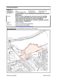
Site Location Plan (for identification purposes only, not to scale)<br />
© Crown Copyright. All rights reserved. Bracknell Forest Borough Council 100019488 2004<br />
Planning Committee 15th March 2012
1 RELEVANT PLANNING HISTORY (If Any)<br />
00/00925/<strong>FUL</strong> Validation Date: 18.09.2000<br />
Works to upgrade perimeter security including erection of perimeter security fence, wall<br />
and gates up to 5.2 metres high. Provision of internal access road and paths and<br />
perimeter road. Erection of 161no. 6 metre high lighting columns<br />
Approved<br />
00/00926/<strong>FUL</strong> Validation Date: 18.09.2000<br />
Erection of new sports and visitors centre following the demolition of existing buildings.<br />
Approved<br />
00/00927/<strong>FUL</strong> Validation Date: 18.09.2000<br />
Alterations to existing staff and visitors car park and cycle parking facillity including<br />
associated landscaping, relocation of lighting and CCTV columns and erection of new<br />
fence to enclose cycle parking area.<br />
Approved<br />
02/0<strong>11</strong>42/LB Validation Date: 06.<strong>11</strong>.2002<br />
Application for listed building consent to demolish Yorkshire House, a building within<br />
the curtilage of a listed building.<br />
Withdrawn<br />
02/01274/<strong>FUL</strong> Validation Date: 18.12.2002<br />
Erection of part two, part three storey building forming 70 bed unit for the<br />
accommodation, treatment and care of Dangerous People with Severe Personality<br />
Disorder (DSPD). Demolition of existing hospital buildings.<br />
Approved<br />
03/00426/T Validation Date: 25.04.2003<br />
Erection of prefabricated single storey building to provide meeting facilites for a<br />
temporary period of three years.<br />
Approved<br />
10/00823/OUT Validation Date: 09.12.2010<br />
Outline application for children's nursery with associated car parking, play area and<br />
landscaping.<br />
(No Decision – Application Currently Under Consideration)<br />
<strong>11</strong>/00744/LB Validation Date: 28.10.20<strong>11</strong><br />
Application for listed building consent for the demolition of Lancashire House, Yorkshire<br />
House and the Richard Dadd Centre, and partial demolition of Berkshire House.<br />
(No Decision – Application Currently Under Consideration)<br />
2 RELEVANT PLANNING POLICIES<br />
Key to abbreviations<br />
BFBCS<br />
BFBLP<br />
RMLP<br />
WLP<br />
SPG<br />
SPD<br />
PPG (No.)<br />
PPS (No.)<br />
Core Strategy Development Plan Document<br />
Bracknell Forest Borough Local Plan<br />
Replacement Minerals Local Plan<br />
Waste Local Plan for Berkshire<br />
Supplementary Planning Guidance<br />
Supplementary Planning Document<br />
Planning Policy Guidance (Published by DCLG)<br />
Planning Policy Statement (Published by DCLG)<br />
Planning Committee 15th March 2012
MPG<br />
DCLG<br />
SEP<br />
Minerals Planning Guidance<br />
Department for Communities and Local Government<br />
South East Plan<br />
Plan Policy Description (May be abbreviated)<br />
BFBLP EN1L Protecting Tree And Hedgerow Cover<br />
BFBLP EN3L Nature Conservation<br />
BFBLP EN7L Other Important Archaeological Remains<br />
BFBLP EN8L Dev On Land Outside Settlements<br />
BFBLP EN12 Historic Parks And Gardens<br />
BFBLP EN20 Design Considerations In New Development<br />
BFBLP EN22 Designing For Accessibility<br />
BFBLP E12 Identified Major Employment Sites<br />
BFBLP M4L Highway Measures New Development<br />
BFBLP M6 Cycling And Walking<br />
BFBLP M7 Access For People With Disabilities<br />
BFBLP M8 Public Transport<br />
BFBLP M9 Vehicle And Cycle Parking<br />
BFBLP R8 Public Rights Of Way<br />
BFBLP SC3 NoReductionInExistingComm Facilities<br />
BFBCS CS1 Sustainable Development Principles<br />
BFBCS CS7 Design<br />
BFBCS CS9 Development on Land Outside Settlements<br />
BFBCS CS10 Sustainable Resources<br />
BFBCS CS12 Renewable Energy<br />
BFBCS CS14 ThamesBasinHeaths SpecialProtectionArea<br />
BFBCS CS19 Location of Employment Development<br />
BFBCS CS24 Transport and New Development<br />
BFBCS CS2 Locational Principles<br />
BFBCS CS23 Transport<br />
SEP 52 Promoting Sustainable Health Services<br />
3 CONSULTATIONS<br />
(Comments may be abbreviated)<br />
Transportation Officer<br />
At present there are a number of issues that still need further work, these are<br />
summarised below.<br />
Planning Committee 15th March 2012
o The design of the access road including the roundabout junction on the A3095<br />
require further work to ensure that safety is not compromised and for vehicles and<br />
pedestrians. Details of the bus gate and car parking arrangement are also required.<br />
o Internal improvements of the existing roads may be required to enhance<br />
pedestrian and cyclist access<br />
o Further capacity analysis is required on the highway network and this should also<br />
include sensitivity testing<br />
o Impacts from car parking and on and off site highway works need to be<br />
considered against the viability of the listed building.<br />
o Construction traffic related to the access road needs to be considered.<br />
Biodiversity Officer<br />
No objection is raised subject to a condition requiring the implementation of the<br />
mitigation measures set out in the ES.<br />
Although mitigation for protected species is achievable an alternative access via<br />
Crowthorne village would be preferable from an ecological perspective. The access<br />
road drawings appear to show a footway running along the northern side of the access<br />
road which has previously been requested to be removed from the point at which it<br />
goes beyond the hospital perimeter. This needs to be amended.<br />
Crowthorne Parish Council<br />
Recommend approval for reasons below;<br />
Assuming that the listed buildings in planning application <strong>11</strong>/00744/LB are demolished,<br />
Crowthorne Parish Council recommends approval in principle of this plan, on the<br />
proviso that any road to the bypass cannot become a 'rat run' into and out of<br />
Crowthorne village.<br />
Parks and Countryside Officer<br />
The <strong>Broadmoor</strong> Estate landscape is one of the most sophisticated asylum landscapes<br />
ever laid out. The proposed development would be harmful to the landscape character<br />
of the Registered Park and Garden, however the hospital development and the<br />
proposed access road are located away from the main area of parkland limiting the<br />
impact on the wider landscape as far as possible. The development will result in a total<br />
remodelling of the hospital and the access road sites with level changes of up to 7-8 m.<br />
The effect on the landscape and ecology can not be underestimated.<br />
It is accepted that the proposed location of the access road cutting through the<br />
woodland W12 is the best option although it leads to the loss of category A trees. Due<br />
to the steeper gradient further south the loss of woodland would be greater and the<br />
visual impact would be more severe.<br />
The proposed level changes to the existing public footpath would result in a gradient<br />
that is too steep and includes steps. Therefore an alternative route without steps and a<br />
gentler gradient should be created. It would be possible to create the alternative route<br />
from Eastern Lane to the east side of woodland W12 and bring it back along the south<br />
side of the access road to meet with the existing footpath route. Additional gates to the<br />
badger fence would be required.<br />
The proposed development would result in narrow woodland areas to the north of the<br />
development and some of the woodland to be removed up to the site boundary leaving<br />
Planning Committee 15th March 2012
a gap in the screen along the north eastern boundary. The space is too limited to<br />
screen the road adequately on the eastern side of the hospital. Additionally the road<br />
level is elevated along this section making it more dominant. The screening relies on<br />
the existing woodland outside the application site along the north eastern boundary.<br />
Any clear felling on the adjoining land could open views of the access road and the<br />
hospital development.<br />
The woodland areas to the north of the proposed hospital are important in screening<br />
the site but would be vulnerable to wind damage as the existing edge of the wood will<br />
be lost. Although woodland edge planting is proposed for this area, the planting will not<br />
protect the remaining woodland in the short term.<br />
Details for the proposed management of the retained woodland are required.<br />
Access <strong>Road</strong> Section 2-2' includes the area where the proposed cycleway was<br />
removed as a raised verge with amenity grass. This verge should be graded to existing<br />
levels and the acid meadow grass extended to this area. The cycle lane along the<br />
Access road is shown further than necessary. It should be stopped at the link with the<br />
perimeter road.<br />
Planting Plans<br />
The Heathy Grassland Verge mixes are not clear. The proposed percentages should<br />
be clarified within the separate groups of plants (shrubs, heathers and grass mixes). All<br />
mixes should add up to 100%. It is also not clear what the plant sizes are proposed for<br />
the shrub mix. The proposed shrub mix should not be planted through the heathland<br />
grass and heathers as the shrubs would quickly take over. The shrubs should only be<br />
included to the rear of the verges along the woodland edge. It also seems unnecessary<br />
to divide the shrub mix to different sizes and spacing within the mix. The spacing has<br />
not been specified for the heathland plants.<br />
Similarly the woodland edge mix includes two different size plant specification and<br />
planting spacings.<br />
As previously mentioned the grass areas should be simplified at the entrance to the<br />
new hospital. The wildflower area should be extended to cover the bank from the<br />
heathland mix at the roundabout up to the woodland edge planting and link with the<br />
proposed wildflower area to the west of the pedestrian access path.<br />
Detailed planting plans have not been provided for the proposed ornamental planting.<br />
A detailed planting plan should be provided or alternatively a landscape condition<br />
should be attached to possible approvals.<br />
Details of ground preparation, staking etc and a 5 year post planting management plan<br />
should be submitted or alternatively these details could be conditioned<br />
The Environment Agency<br />
The information submitted is inadequate to confirm that it is satisfied with the proposal,<br />
and therefore a holding objection is raised.<br />
Natural England<br />
No objection subject to conditions<br />
Berkshire, Buckinghamshire and Oxfordshire Wildlife Trust<br />
Has some concerns with respect to air quality, lighting, construction noise,<br />
invertebrates, water quality and quantity on Wildmoor Heath and possible works to<br />
Planning Committee 15th March 2012
South <strong>Road</strong> and a crossing facility over Rackstraw <strong>Road</strong>. Consider like for like roost<br />
replacement for bats is required (not just provision of bat boxes in trees).<br />
Berkshire Archaeology<br />
The site is located within an area of archaeological potential and a number of undated<br />
features were located within the site during a small scale evaluation. Some areas of<br />
the site have been impacted to such a degree that no further archaeological<br />
investigation is recommended. However there are some areas whether further<br />
investigation is appropriate. The most suitable methods will depend on the current<br />
setting and the nature of the impact. A condition is recommended to secure an<br />
appropriate programme of archaeological work prior to development commencing.<br />
The Garden History Society<br />
(No comments received at time of producing this report).<br />
English Heritage<br />
New development will entail substantial harm to the cultural heritage significance of the<br />
<strong>Broadmoor</strong> estate which needs to be weighed against the public benefits, which are<br />
also accepted as being substantial. If the development is accepted it is essential that<br />
appropriate steps are taken to ensure that the listed building has a secure future;<br />
further details are provided so the impact of the access road on the park can be<br />
properly assessed (this must be as discrete as possible, conceived as an entrance<br />
drive through a park to a country house, involving a minimum of engineering works);<br />
revised proposals are submitted for the truncation of Berkshire House.<br />
Royal Society For The Protection Of Birds<br />
(No comments received at time of producing this report).<br />
Berkshire Gardens Trust<br />
The registered park and garden is a very good example of surviving Victorian asylum<br />
design and therefore is of particular significance. Concerned that proposed<br />
development will expand into currently undeveloped parkland or forest, introducing new<br />
roads, cuttings, fencing and buildings and that aspects of the development will have an<br />
adverse impact on the design, character and setting of the park e.g. the impact on<br />
views to the listed building and terraces as a result of the two lines of 5.2m high fencing<br />
with access roads on the edge of the park. Some elements will be particularly visually<br />
intrusive, detracting from the character and appearance of the park, and enjoyment by<br />
the public. Views east along the lower terrace from the upper storey of the male block<br />
will be adversely affected by the loss of enclosure presently provided by the listed<br />
building backdrop. However the proposed wall up to the listed building and the<br />
removal of lighting columns are in principle an improvement<br />
4 REPRESENTATIONS<br />
No representations have been received.<br />
5 OFFICER REPORT<br />
Summary Of Key Aspects Of The Proposal (If Any)<br />
Planning Committee 15th March 2012
Proposed site area (ha): 50 ha (area within new secure perimeter – 8ha)<br />
Proposed floor area (non-residential): High Secure Mental Health <strong>Hospital</strong> - 32,988 sq<br />
m (net increase)<br />
Proposed number of parking spaces: 547 (net loss of 145)<br />
INTRODUCTION<br />
This application is reported to committee because it represents a departure from the<br />
development plan as it conflicts with policies relating to land outside of settlements. A<br />
separate listed building consent application has also been submitted for the demolition<br />
of various curtilage listed buildings on the site to enable this development to take place.<br />
This is reported separately on this agenda.<br />
<strong>Broadmoor</strong> <strong>Hospital</strong> provides mental health services in a high secure environment for<br />
288 male patients from London and the South of England. Although the layout of the<br />
original hospital building has changed little since opening in 1863, the hospital has<br />
been subject to numerous built extensions in response to changes in the approach to<br />
mental health care and the changing needs of its patients. In 1871 it was expanded to<br />
include facilities for women. In 1985 a number of additional wards and support facilities<br />
were completed, including Oxford House; Bedford House; the Administration and<br />
Support Services Building and the Energy Centre and Support Services facilities<br />
outside the secure perimeter. Most recently the Paddock Centre was constructed in<br />
2005 to provide a facility for patients with dangerous and severe personality disorders.<br />
The existing hospital buildings are no longer appropriate for a modern mental health<br />
hospital and present the applicant, the West London Mental Health Trust (the Trust),<br />
with serious difficulties in delivering effective clinical care. In response to this the Trust<br />
has submitted the present application which seeks to redevelop <strong>Broadmoor</strong> <strong>Hospital</strong> to<br />
deliver a modern high secure hospital.<br />
PROPOSAL<br />
This application seeks full planning permission for the erection of a new secure mental<br />
health hospital following demolition of many of the existing hospital buildings, a new<br />
access road and junction onto the A3095 Foresters Way and associated development.<br />
The existing <strong>Hospital</strong> currently provides a total of 288 beds. This will reduce to 234<br />
beds following the proposed redevelopment.<br />
The proposed hospital would be primarily located within a new secure perimeter on the<br />
east side of the existing hospital. The new hospital would include the existing Paddock<br />
Centre building which would be retained and extended. All the other buildings currently<br />
within the proposed secure perimeter would be demolished, including the curtilage<br />
listed female block and Essex House, newer patient wards and ancillary buildings like<br />
the energy centre.<br />
Outside the secure perimeter various administrative and ancillary uses would be<br />
located, including offices, car parking, and an energy centre (replacing the existing one<br />
that would be demolished). Most of these uses would be accommodated within<br />
existing buildings although some buildings such as the administration building would be<br />
upgraded. The retained Berkshire House would be used as administrative offices by<br />
the Trust.<br />
As well as the construction of a new hospital this application also seeks permission for<br />
a new 1.2 km access road linking the proposed hospital with Foresters Way. The<br />
proposed access road would have a carriageway width of 6.5m and be flanked by a 3m<br />
Planning Committee 15th March 2012
footpath and 2m wide verge along its western length or a 0.5m hard strip on both sides<br />
further east. The construction of the access road would require retaining walls,<br />
extensive ground excavations in the form of cuttings and embankments, fences and<br />
drainage features. A new roundabout is proposed at its junction with Foresters Way.<br />
The new road would extend westwards from this junction close to the northern<br />
boundary of the <strong>Broadmoor</strong> Estate, wrap around to the south of the fish ponds before<br />
crossing the public footpath, the Three Castles Way, and continuing up a steep slope<br />
onto the ridge. It would follow the eastern and northern boundaries of the proposed<br />
new secure perimeter before merging into the existing Kentigern Drive just east of the<br />
main car park. Shortly before it rejoins the existing road alignment there would be a<br />
mini-roundabout where a new access road leading to the main entrance of the new<br />
hospital would diverge to the south. A second mini-roundabout would mark the<br />
junction where this road splits with one arm going directly into the secure perimeter and<br />
the other serving the new parking area and administration buildings outside the secure<br />
perimeter.<br />
To accommodate the new buildings for the hospital while providing appropriate internal<br />
links to the retained buildings requires the creation of a plateau with the removal of<br />
some 5 metres of existing ground from the area around the existing energy centre.<br />
Even with this reduction in level there remains a significant level difference between the<br />
lower land to the south and across to Foresters Way and the levels of the new<br />
buildings.<br />
The new hospital would be accessed by vehicles from Foresters Way only. Pedestrian<br />
and cycle access would continue to be from Crowthorne village using existing routes<br />
along Upper and <strong>Lower</strong> <strong>Broadmoor</strong> <strong>Road</strong>s from the north and west and South <strong>Road</strong><br />
and School Hill from the south. The new hospital inside the secure perimeter would<br />
have a single entrance for all users on its northwest side. To stop vehicles “rat<br />
running” between the new hospital and Crowthorne village a bus gate is proposed at<br />
the western end of Kentigern Drive. This would permit cycles, buses and emergency<br />
vehicles to pass but prevent all other vehicles from using the existing road network as a<br />
through route to the hospital.<br />
With the exception of the energy centre all of the new buildings proposed for the<br />
hospital would be located within the secure perimeter. This prevents patient access<br />
beyond the secure environment and controls external access to the hospital through a<br />
single controlled entrance building. The perimeter itself is presently formed by a wall<br />
but in the new hospital this would be comprised of two 5.2m high anti-climb, dark green<br />
or black steel mesh fences located 7.5m apart surrounding the hospital on all sides.<br />
The secure perimeter would include extensive electronic surveillance equipment, close<br />
circuit TV and lighting. A service road would run parallel to the entire secure perimeter<br />
on the outside.<br />
The new buildings would comprise a new two storey entrance building into the hospital<br />
itself which would control access through the secure perimeter and provide security<br />
functions and support accommodation. The building would have a maximum height of<br />
16m and would be clad in red brick and coloured render with an aluminium, gently<br />
pitched roof.<br />
Beyond the entrance building would be a three storey multifunctional central building<br />
forming the social hub of the hospital containing accommodation for healthcare,<br />
hairdresser, shop, café, spiritual suite, and supporting services. The elevational<br />
treatment would comprise horizontal bands of glazing of different heights cut from<br />
planes of coloured render and timber cladding. The building would have a flat “green”<br />
roof.<br />
Planning Committee 15th March 2012
Three new ward blocks would be located in a gradual curve on the eastern side of the<br />
new hospital between the central building and the existing Paddock Centre. The wards<br />
would wrap around a central garden. Each ward would be “C” shaped with patient<br />
gardens located between the two wings of each block. The ward blocks comprise<br />
patient living accommodation together with functional support facilities such as<br />
kitchens, laundry and offices. The northernmost ward block closest to the central<br />
building would be single storey while the other two would be two storeys with a height<br />
of 8.1m. The ward blocks have been designed to provide patients with views of the<br />
landscape outside the secure perimeter. The blocks would be clad in a coloured<br />
render with some limited use of timber cladding on the stairs at the end of the ward<br />
wings. Roofs would have aluminium finishes.<br />
The west side of the hospital would mainly be taken up with recreational facilities<br />
including a multi-use games area (MUGA), kitchen garden and indoor recreational<br />
space and music performance facilities in an extension to the Paddock Centre.<br />
DEVELOPMENT NOT INCLUDED IN THIS APPLICATION<br />
The construction of the new hospital would displace a number of existing uses such as<br />
staff training, transport and supplies. With the exception of the energy centre, works to<br />
buildings outside the secure perimeter that are required to accommodate these<br />
displaced uses will be subject to separate planning applications and do not fall to be<br />
considered under the current application.<br />
A substantial part of the existing hospital is accommodated within the original grade II<br />
listed buildings built between 1859 and 1863. A new wall is proposed to the west of the<br />
Paddock Centre to separate the new hospital from the retained listed buildings and<br />
terraces, and a number of modern buildings that form part of the present hospital.<br />
These buildings (i.e. all those buildings south of Kentigern Drive and west of the<br />
proposed new hospital) and the terraces and kitchen garden to the south do not form<br />
part of the current application and the applicant has indicated that once the new<br />
hospital is built and patients transferred the listed building and surrounding land will be<br />
surplus to its requirements and will be sold. The red line denoting the application site<br />
has been carefully drawn to include only land that it is intended will form part of the<br />
eventual hospital estate and to exclude those areas that would be sold.<br />
Notwithstanding that the listed building is excluded from the application site, the impact<br />
that the proposed development would have on the listed building, in particular in<br />
respect of the need to secure a viable reuse of the building once it has become surplus<br />
to the hospital’s requirements, is a material planning consideration for this application.<br />
Members will also be aware that Policy SA4 of the Draft Submission Site Allocations<br />
DPD (SADPD) which at the time of writing this report was the subject of a period of<br />
public consultation ending on the 12th March, provisionally allocates land at <strong>Broadmoor</strong><br />
for a mixed development including a redeveloped hospital and a new access road, up<br />
to 210 residential units within the walled garden, up to 60 retirement apartments<br />
outside the walled garden, a small research park, the re-use of the existing hospital<br />
buildings for an appropriate use, a care home/nursing home, on-site open space and<br />
suitable alternative natural greenspace (SANG). Only the redeveloped hospital and the<br />
new access road fall to be considered under the current application.<br />
SITE<br />
The hospital lies within the wider <strong>Broadmoor</strong> Estate which comprises approximately<br />
130 ha of parkland. Within this estate the hospital itself is contained within a secure<br />
Planning Committee 15th March 2012
perimeter covering approximately 18 ha. Outside the secure perimeter are located<br />
various ancillary hospital facilities, including accommodation for staff training, offices,<br />
transport, supplies, an energy centre and car parking. Surrounding this built hospital<br />
core area is the park comprising many hectares of open woodland and farmland, the<br />
formal terraced gardens, kitchen garden, fish ponds and playing fields. There are also<br />
numerous residential properties scattered through the park providing accommodation<br />
for staff, including a purpose built staff hostel at Cricket Field Grove.<br />
The application site itself is not clearly related to existing physical features on the<br />
ground and includes the northern and eastern parts of the estate which it is planned will<br />
ultimately contain the land to be permanently retained by the Trust. This site excludes<br />
those parts of the estate which the Trust intend to dispose of, including the listed<br />
building and adjacent modern buildings south of Kentigern Drive and west of the new<br />
hospital, the terraces and kitchen garden, the farm (excluding the northern part which is<br />
required for the proposed access road) and those parts of the Estate to the south of<br />
Upper <strong>Broadmoor</strong> <strong>Road</strong> and west of School Hill.<br />
.<br />
<strong>Broadmoor</strong> <strong>Hospital</strong> is located on a south facing ridge approximately 1 km east of<br />
Crowthorne village within an extensive area of coniferous forest and heathland forming<br />
part of the <strong>Broadmoor</strong> to Bagshot Woods and Heaths Site of Special Scientific Interest<br />
(SSSI) to the north and east and the Sandhurst to Owlsmoor Bogs & Heaths SSSI to<br />
the south west. These areas also form part of the Thames Basin Heaths Special<br />
Protection Area (SPA).<br />
The hospital’s southerly aspect is a very important feature of the site and was an<br />
important aspect in the original choice of this site as a lunatic asylum in the mid 19th<br />
Century. The site provides extensive views over an area of low lying grassland with<br />
stands of woodland forming shelter belts around the margins and two prominent knolls<br />
within the park below. East of <strong>Broadmoor</strong> Farm the ground rises in a series of<br />
undulations to a plateau occupied by Crowthorne Woods.<br />
The Estate is bounded to the north by the Devil's Highway. This boundary is defined by<br />
woodland which continues to follow the perimeter of the Estate to the northwest and to<br />
the west screens the hospital from Crowthorne village. Land to the south of the hospital<br />
is currently in agricultural use and forms part of the original hospital landscape included<br />
in the English Heritage Register of Parks and Gardens of Special Historic Interest.<br />
Foresters Way forms the majority of the eastern and south-eastern boundary of the<br />
Estate and South <strong>Road</strong> forms part of the western boundary. The remainder of the<br />
western and part of the southern boundaries border residential areas within<br />
Crowthorne.<br />
PRINCIPAL PLANNING CONSIDERATIONS<br />
(1) Principle of the development<br />
Existing policy<br />
The Council’s adopted Core Strategy and Proposals Map designates the whole of the<br />
application site as land outside a defined settlement (Policy CS9). This carries forward<br />
the previous designation under saved Policy EN8 of the Local Plan. These policies<br />
seek to protect land outside settlements for its own sake, and in particular to protect<br />
such land from development that would adversely affect its character, appearance or<br />
function. This general requirement is considered to be of even greater importance in<br />
the case of <strong>Broadmoor</strong> as the whole site also lies within the English Heritage Register<br />
of Parks and Gardens of Special Historic Interest where development should not be<br />
Planning Committee 15th March 2012
permitted which would result in damage to, or the erosion of, parks and gardens of<br />
special historic interest and their settings.<br />
Notwithstanding its countryside designation the majority of the site is already<br />
developed with existing hospital buildings, the only significant greenfield development<br />
being the proposed access road. Previously developed land is defined as that which is<br />
or was occupied by a permanent structure, including the curtilage of the developed<br />
land and any associated fixed surface infrastructure. As such this site is considered to<br />
conform to the Government’s definition of previously developed land. The<br />
Government’s priority is to locate new development on previously developed sites and<br />
a key objective of Government policy is that Local Planning Authorities should continue<br />
to make effective use of land by re-using land that has been previously developed.<br />
This principle is also recognised in the identification of the vast majority of the site as a<br />
major employment site outside defined settlements under Policy E12 of the Local Plan.<br />
This designation is also rolled forward in Core Strategy Policy CS19 and the Proposals<br />
Map. Within these areas development involving change of use, infilling and<br />
redevelopment are acceptable in principle where they:<br />
• Do not have a materially greater impact upon the existing character of the site<br />
• Would not exceed the height of the existing building<br />
• For infilling, would not lead to a major increase in the developed proportion of the<br />
site<br />
• For redevelopment, would not occupy a larger area of the site than that of the<br />
existing main built up area<br />
• Would not create visual or other environmental damage or result in<br />
inconvenience or danger to the public highway, or other harm<br />
The supporting text to this Policy states “Sites such as <strong>Broadmoor</strong> are large employers<br />
in the Borough and their specialist future development needs should be acknowledged,<br />
taking account of the quality of surrounding landscape and the national importance of<br />
these establishments”.<br />
In addition to the above site specific policies, also of relevance are more general<br />
national, regional and local policies which seek to encourage the delivery of healthcare<br />
facilities and sustainable economic development through providing or maintaining<br />
employment opportunities. Local Plan Policy SC3 seeks to prevent the loss of existing<br />
community facilities. Any reduction in the existing range of facilities would result in an<br />
inadequate provision of social infrastructure and place increased demands on<br />
remaining facilities. The supporting text at paragraph 8.27 clarifies that this policy<br />
allows for the replacement of existing facilities.<br />
South East Plan Policy S2 is also considered to be relevant. This states “Local<br />
Planning Authorities should work closely with the NHS across its delivery bodies to<br />
ensure the provision of additional and reconfigured health and social care facilities to<br />
meet the anticipated primary care and capacity needs of local communities. Where<br />
need is identified land should be made available for additional community, social and<br />
primary care facilities”.<br />
While these policies are primarily directed to local and regional provision, it is<br />
considered that they also lend support to the present proposal for social infrastructure<br />
intended to meet a national need. The applicant has stated that the Government’s<br />
health policy is to retain three high secure mental health hospitals, including the<br />
retention and redevelopment of <strong>Broadmoor</strong>. The proposed development will ensure a<br />
nationally significant health care facility is re-provided and made “fit for purpose” for the<br />
Planning Committee 15th March 2012
care of patients. It is therefore considered that these policies provide strong support for<br />
the proposed development.<br />
<strong>Broadmoor</strong> hospital is a major employer within the Borough and the retention of this<br />
employment is an important consideration. While the current plans would result in a<br />
small reduction in the number of staff employed at <strong>Broadmoor</strong>, this proposal would<br />
secure the retention of 1,100 jobs. Furthermore the disposal of substantial parts of the<br />
site, including the listed building to other employment generating uses in the longer<br />
term, is likely to result in an overall increase in employment provided on the wider<br />
<strong>Broadmoor</strong> site.<br />
Government policy set out in PPS4 requires Local Planning Authorities to adopt a<br />
positive and constructive approach towards planning applications for economic<br />
development. This proposal is considered to promote sustainable economic growth and<br />
is therefore supported in principle by PPS4. Similar objectives are set out in the<br />
Government’s Draft National Planning Policy Framework.<br />
In conclusion on this issue the proposed new hospital itself, while outside the<br />
settlement boundary of Crowthorne, would be located on a site that is already largely<br />
developed. The development proposed would extend the built envelope slightly<br />
contrary to Policy E12. However in view of the strong support for this type of<br />
development and the identified need for the development, it is considered that these<br />
considerations outweigh the small additional adverse effect on the character,<br />
appearance or function of the countryside at this location.<br />
The position with the proposed access road is less straightforward. This would result in<br />
a substantial engineering structure within what is presently undeveloped greenfield<br />
countryside. As described later, the proposed access road would also result in harm to<br />
the historic parkland through visual intrusion of the road and traffic, and would alter its<br />
historic design. It would lead to the urbanisation of the countryside; the loss of<br />
individual mature trees and large areas of woodland; would impact on ecology and<br />
have a detrimental impact on the attractiveness and public enjoyment of public footpath<br />
8 which forms part of the long distance footpath The Three Castles Path. These<br />
impacts are considered to result in very significant harm to the countryside and historic<br />
landscape and therefore the access road should only be permitted in exceptional<br />
circumstances. This harm will therefore need to be weighed against the benefits of the<br />
proposal which are considered later in this report.<br />
Emerging Local Policy<br />
The Council is preparing a Site Allocations DPD (SADPD) to achieve the vision and<br />
spatial objectives of the Core Strategy. One of the main functions of the document will<br />
be to deal with the Borough’s housing requirements and allocate specific sites. The<br />
SADPD was approved for submission to the Secretary of State (SoS) by full council in<br />
November 20<strong>11</strong> and has recently been subject to a period of public consultation. The<br />
SADPD will now be submitted to the SoS and it is anticipated that a formal examination<br />
in public will take place in Autumn 2012.<br />
The wider <strong>Broadmoor</strong> site is included in the Draft Submission Document. Policy SA4<br />
identifies the site for a comprehensive well-designed mixed use development including:<br />
• A redeveloped hospital and ancillary buildings.<br />
• A maximum of 210 residential units (including affordable housing) within the<br />
walled garden area (the final number to be subject to further consideration of the<br />
Planning Committee 15th March 2012
impacts on the heritage assets of the site and the justification for the development<br />
including the needs of the Listed Building).<br />
• 60 retirement apartments outside the walled garden (the final number to be<br />
subject to further consideration of the impacts on the heritage assets of the site and the<br />
justification for the development including the needs of the Listed Building).<br />
• A small research park.<br />
• Re-use of the existing hospital buildings for an appropriate use.<br />
• Care home/nursing home.<br />
• On-site open space and Suitable Alternative Natural Greenspace (SANG).<br />
• New access road.<br />
Comprehensive development proposals have yet to be brought forward in respect of<br />
Policy SA4. The present application only seeks permission for the first and last items<br />
on the above list. The application site lies within the land identified within the Draft<br />
Submission Illustrative concept plan as ‘mixed use area’.<br />
It is not considered that the proposed hospital and access road would directly prejudice<br />
the delivery of the SADPD, however it is important to note that the SADPD seeks a<br />
comprehensive solution to the <strong>Broadmoor</strong> site, including a suitable re-use of the listed<br />
building, which would not be secured through the current application. It is considered<br />
that there is a significant risk, as outlined later in this report, that in order to secure a<br />
viable reuse for the listed building a larger land take may be required than anticipated<br />
in the SADPD. If this is the case, there is a possibility that by looking at this site on a<br />
piecemeal basis, the comprehensive strategy set out in Policy SA4 may not be<br />
deliverable in full.<br />
(2) Impact on heritage assets<br />
The whole site lies within the English Heritage Register of Parks and Gardens of<br />
Special Historic Interest. Although the application site does not include the principal<br />
Grade II listed building it does include a number of curtilage listed buildings which<br />
would be demolished or partially demolished, and would impact on the setting of the<br />
listed building. Heritage issues are therefore of particular importance in the<br />
consideration of this application. The Government’s overarching aim as set out in PPS5<br />
is that the historic environment and its heritage assets should be conserved and<br />
enjoyed for the quality of life they bring to this and future generations. Policy HE9<br />
states: "Loss affecting any designated heritage asset should require clear and<br />
convincing justification. Substantial harm to or loss of a grade II listed building, park or<br />
garden should be exceptional.... Where the application will lead to substantial harm to<br />
or total loss of significance local planning authorities should refuse consent unless it<br />
can be demonstrated that …the substantial harm to or loss of significance is necessary<br />
in order to deliver substantial public benefits that outweigh that harm or loss".<br />
Local Plan Policy EN12 states that development will not be permitted which would<br />
result in damage to, or the erosion of, parks and gardens of special historic interest and<br />
their settings.<br />
English Heritage and The Victorian Society have advised that the proposed hospital<br />
development will directly harm the cultural heritage significance of the site. The<br />
significance of <strong>Broadmoor</strong> to a great extent depends on the fact that it is a complete<br />
hospital complex. All the different elements form part of the original complex and are<br />
therefore of illustrative historic value in documenting how the hospital was conceived<br />
and organised. Direct harm will result to the site’s heritage significance from the<br />
demolition of the Female Block and Essex House and the partial loss of the circuit drive<br />
and reservoir drive entailed by the construction of the new access road.<br />
Planning Committee 15th March 2012
The proposed loss of Essex House is of greatest concern. This makes an important<br />
contribution to the architectural qualities of the hospital due to the way it steps forward<br />
from the complex, dominating the ridge on which it sits. It also forms an important part<br />
of the setting of the listed building. As noted by the Berkshire Gardens Trust views east<br />
along the lower terrace from the upper storey of the male block will be adversely<br />
affected by the loss of enclosure presently provided by Essex House. This building<br />
also acts as a screen between the listed building and the modern Paddock Centre<br />
which is to be retained under the current proposals. However the proposed wall that<br />
would extend south from the retained Berkshire House and the removal of lighting<br />
columns are in principle an improvement and provide limited mitigation for the loss of<br />
Essex House.<br />
The proposed access road would result in significant harm to the registered historic<br />
park and garden. The Heritage Strategy that forms part of the application identifies the<br />
access road as having the following adverse heritage impacts: "Visual intrusion of the<br />
road and traffic, including lighting and road signage, passing through northern edge of<br />
historic parkland. New approach route through the park alters the historic design."<br />
The proposed development would therefore entail substantial harm to the heritage<br />
significance of the <strong>Broadmoor</strong> Estate as a whole. This harm must be weighed against<br />
the national public benefits arising from the improved mental health hospital and the<br />
local importance of retaining a significant local employer offering a wide range of job<br />
opportunities within the Borough.<br />
There is a national need for high secure mental health services. <strong>Broadmoor</strong> is one of<br />
only three sites within the country providing these services. The Department of<br />
Health’s policy is to retain all three sites, and in the case of <strong>Broadmoor</strong> to provide a<br />
new, fit for purpose, high secure mental health hospital.<br />
The existing hospital buildings are no longer appropriate for a modern mental health<br />
hospital and present the Trust with serious difficulties in delivering effective clinical<br />
care. An external review by the Commission for Health Improvements in 2003<br />
concluded that “the overwhelming majority of ward areas at <strong>Broadmoor</strong> <strong>Hospital</strong> are<br />
totally unfit for purpose”. In 2009 the Care Quality Commission found that parts of the<br />
hospital “are neither safe nor conducive to high quality care” and that the<br />
redevelopment plans for <strong>Broadmoor</strong> must be progressed without further delay.<br />
This is therefore an important national public benefit that the development would<br />
provide.<br />
A second material consideration relates to the importance of retaining a significant local<br />
employer within the Borough. As reported above although the current plans would<br />
result in a small reduction in the number of staff employed at <strong>Broadmoor</strong>, this proposal<br />
would secure the retention of 1,100 jobs. Furthermore the disposal of substantial parts<br />
of the site, including the listed building to other employment generating uses in the<br />
longer term, is likely to result in an overall increase in employment provided on the<br />
wider <strong>Broadmoor</strong> site.<br />
Alternative options<br />
Although the proposed development would provide a significant national public benefit,<br />
in view of the harm it would cause to the heritage significance of the <strong>Broadmoor</strong> Estate<br />
it is also necessary to consider whether there are any other options which could also<br />
Planning Committee 15th March 2012
provide this public benefit, including the consideration of alternative suitable sites other<br />
than <strong>Broadmoor</strong>.<br />
The reasons for the redevelopment of <strong>Broadmoor</strong> have been carefully considered by<br />
the Trust and once it was declared that the current <strong>Broadmoor</strong> facility was unfit for<br />
purpose, the Trust considered the option for relocating patients from <strong>Broadmoor</strong> to the<br />
other two high secure hospitals at Ashworth and Rampton. The National Oversight<br />
Group (NOG) for high secure services reviewed the need for three high secure<br />
services in the United Kingdom and concluded after having considered evidence and<br />
options that retaining only two secure hospitals in the country was unacceptable and<br />
that the current <strong>Broadmoor</strong> facility therefore had to be re-provided.<br />
The Trust also considered the potential for the transfer of patients from <strong>Broadmoor</strong> to<br />
other existing mental health units. This review lead to the relocation of female patients<br />
as it was recognised that most female patients did not present the same level of<br />
security risk as male patients. A National Capacity Review concluded that a maximum<br />
of 50 high secure beds were required nationally for female patients and Rampton was<br />
selected as the location to provide these beds. Most female patients, who did not<br />
require secure care, were relocated to a newly constructed Enhanced Medium Secure<br />
facility for women at St Bernard’s <strong>Hospital</strong> in Ealing, West London.<br />
It was therefore concluded that a new hospital was required for male patients only. A<br />
capacity review in 2006 on the amount of accommodation required for the male<br />
patients concluded that there was a need for 266 beds. Following this review, the Trust<br />
carried out a search for suitable alternative sites. Chapter 4 of the Environmental<br />
Statement (ES) sets out the main alternative sites considered in 2006. The original<br />
search parameters in 2006 were as follows:<br />
1. 12-15 ha in the south of England;<br />
2. Level site (for the provision of associated buildings to serve the hospital);<br />
3. Minimal overlooking;<br />
4. The location must be isolated with some access to public transport and a population<br />
base;<br />
5. A countryside aspect.<br />
The focus of the original search was to look at alternative sites in the south of England.<br />
The reason for this is that the current facility and proposed new facility will have to<br />
serve the south of England as the rest of the country is covered by the two other high<br />
secure mental health hospitals in Merseyside and Nottinghamshire.<br />
Over 150 potential sites were identified, based on a review of the relevant planning<br />
authorities’ major development site allocations; a review of (former) English<br />
Partnerships sites and a review of the Defence Estates listing of surplus land. From this<br />
initial long-list, the site selection was refined, based on the requirements on the search<br />
parameters which resulted in a short-list of 18 potential sites across southern England.<br />
Appendix 4.5 of the ES sets out that the majority of these have planning permission,<br />
some with development partly complete, therefore, these are no longer appropriate<br />
options to consider, leaving the only real option to consider development within the<br />
<strong>Broadmoor</strong> Estate.<br />
Having decided that no alternative off-site option was suitable the Trust carried out a<br />
further review of the need for high secure facilities. This review showed a reduction in<br />
the number of beds required and recommended that just 210 beds be provided at<br />
<strong>Broadmoor</strong>. The Trust has added a further 24 units for flexibility in terms of future<br />
Planning Committee 15th March 2012
capacity, so revised options were considered for a 234 bed facility (compared to the<br />
original 266 bed facility).<br />
In light of this review and the passage of time since the original site search in 2006, the<br />
Trust has reviewed its site selection criteria and considered a number of additional<br />
sites, including local sites such as TRL. These, together with further justification as to<br />
why <strong>Broadmoor</strong> is the only suitable site have been included within an addendum to the<br />
ES submitted in February 2012. One of the reasons why it was considered necessary<br />
to carry out a further site search was because in June 20<strong>11</strong> the Government<br />
announced plans to release public sector land. As a major public sector owner of land,<br />
the NHS was expected to contribute to this initiative. There was therefore a call on all<br />
NHS Trusts to identify land and buildings which were no longer required or likely in the<br />
future to be needed for health service purposes. The Trust appraised the list of surplus<br />
sites using its established search criteria to ensure that no more suitable alternative<br />
sites existed. However none of the current identified surplus land was considered<br />
appropriate for the relocation of <strong>Broadmoor</strong> secure mental health hospital.<br />
Ultimately therefore all the off-site options looked at were excluded as they did not<br />
meet the appraisal criteria and they would not have been best value for money as the<br />
Trust would have had to purchase the land required and would have had to re-provide<br />
additional facilities such as the newly built Paddock Centre (72 beds). Furthermore the<br />
off-site options would have had additional risks in introducing a new high secure mental<br />
health hospital into an area where there were not already high secure services.<br />
Retaining the facility at <strong>Broadmoor</strong> on the other hand has a number of major<br />
advantages. It is a well located facility in the M3 and M4 corridor close to London<br />
providing important transport links for both staff and visitors. In addition it has specialist<br />
highly trained staff. If the Trust were to consider moving a long way from <strong>Broadmoor</strong> it<br />
is concerned that it may lose its highly trained staff if they are not prepared to move.<br />
The Trust could therefore be faced with additional recruitment and training costs<br />
impacting on the viability of the proposed new build solution.<br />
Location is also important for patients’ visitors. Typically patients who are placed in the<br />
<strong>Broadmoor</strong> facility tend to have links to the south (including London), either because<br />
they live in the south of England/London or have family and friends from the south.<br />
The isolated location with minimal overlooking and countryside views are some of the<br />
main underlying principals as to why Sir Joshua Jebb chose the current location for the<br />
original hospital. It is in an area of coniferous forest and heathland that has a diverse<br />
and undulating landscape and has extensive views over natural green space and<br />
farmland and provided an effective therapeutic setting which the Victorians believed<br />
was beneficial to the recovery of patients with mental health problems. The Trust has<br />
advised that the same principle continues to be widely regarded by mental health<br />
professionals today. The therapeutic estate is considered to be a very important<br />
element of the environment in which to treat patients, many of whom require specialist<br />
care in a high secure environment over several years. Whilst the fabric of the current<br />
buildings can no longer provide the modern facilities needed to provide such care, the<br />
opportunity exists at <strong>Broadmoor</strong> to design a new hospital that can maximise the<br />
opportunity to use outside space and views of the surrounding countryside which are<br />
important components of the clinical model to maximise recovery and enable reduced<br />
lengths of stay.<br />
In light of the above, it is accepted that <strong>Broadmoor</strong> is the most suitable location for<br />
providing a high secure mental health hospital in the south of England.<br />
Planning Committee 15th March 2012
Therefore it is concluded that the test set out in Policy HE9 of PPS5 has been met so<br />
far as the new hospital is concerned because, although the application will lead to<br />
substantial harm to the significance of a heritage asset the applicant has demonstrated<br />
that this is necessary in order to deliver substantial public benefits that outweigh that<br />
harm.<br />
As stated above, the case for the proposed access road is less straightforward and as<br />
it impacts on a number of separate issues it will be considered in detail later in this<br />
report.<br />
The future re-use of the listed building<br />
Should Members decide to grant planning permission for the new hospital it is<br />
important to ensure that the direct and indirect harm to heritage assets identified above<br />
is minimised and that steps are taken to mitigate the harm to the listed Victorian<br />
hospital complex as far as possible. The most important areas where mitigation can be<br />
provided is in securing a viable future reuse for the listed building, together with various<br />
enhancement measures to restore some of its original features and setting.<br />
Although the listed building does not form part of the application site, the impact of the<br />
current application for its future use is a material planning consideration. The<br />
immediate implication of granting planning permission for a new hospital would be that<br />
the current use of the listed building would cease as patients were transferred into the<br />
new accommodation. The existing listed building would then become redundant, and<br />
unless a new use could be found the building could be left without a viable future use.<br />
It is therefore important that the grant of permission for the replacement hospital does<br />
not prejudice the satisfactory retention and viable re-use of the listed building. The<br />
applicant has considered possible alternative uses for the listed building, but<br />
acknowledges that there is very limited scope for viable alternative uses, not least<br />
because of the building’s location within the 400 metre buffer of the Thames Basin<br />
Heaths SPA which rules out a residential conversion. The applicant in its submission<br />
considers that the most viable uses would be for a hotel or offices. However English<br />
Heritage has commented that the long narrow linear plan form does not make it ideal<br />
for offices, even if there was a demand for this use. Notwithstanding this the building<br />
could attractive as a Headquarters building for a major company.<br />
The applicant considers that a hotel reuse would represent the best use for the site, as<br />
in principle the listed buildings could lend themselves to a satisfactory high end hotel<br />
conversion so long as sufficient land was included within the curtilage to ensure that an<br />
attractive and viable hotel could be developed here. Nevertheless a hotel conversion is<br />
considered to remain a high risk strategy in terms of providing a viable reuse of the<br />
listed building. No developer partner has been identified or marketing undertaken. The<br />
true costs of restoration and conversion are unknown, and given the security measures<br />
in place in the building at present which make access to the building difficult, are likely<br />
to remain unknown for some time. The listed building site would not come forward for<br />
development until works to the new hospital are complete which is unlikely to be before<br />
2017. The state of the hotel market is impossible to predict so far ahead.<br />
Furthermore serious concerns remain about the viability of a four or five star hotel<br />
located directly adjacent to an operational high secure mental health hospital and<br />
sharing the same access past the hospital. The applicant contends that this will not<br />
affect the viability of a hotel use based on successful conversions of prisons and<br />
mental health institutions elsewhere, and the fact that residential developers have<br />
previously shown interest in buying land within the <strong>Broadmoor</strong> estate and next to<br />
Planning Committee 15th March 2012
secure institutions elsewhere in the Country. However the examples of conversions<br />
mentioned all involve fully redundant sites, where the associations are historic rather<br />
than ongoing and are therefore not directly comparable. There are also doubts that<br />
just because a residential developer would be prepared to purchase land close to an<br />
operational secure facility the same would apply to a commercial hotel operator.<br />
It is therefore possible that when the listed building comes on the market the costs of<br />
restoration and conversion could exceed its value making it unattractive to potential<br />
operators with the consequent risk that it could have a negative value (a “conservation<br />
deficit”). It is also possible that some of the elements suggested for inclusion as part of<br />
a comprehensive mixed use development at <strong>Broadmoor</strong> in Policy SA4 of the Draft<br />
Submission Site Allocations DPD would be seen by potential developers as<br />
compromising the setting and approach to the listed building to such an extent that it<br />
would not be attractive to the sort of high end operator it is hoped to attract. In<br />
particular there are concerns that the proposed care home/nursing home and small<br />
research park to the north of the listed building and the proposed residential<br />
development to the south in the walled garden could significantly detract from the<br />
attractiveness of the site for a high end operator.<br />
These are serious concerns that if realised could make it very difficult to find a viable<br />
reuse for the listed building if the new hospital is built. One way to reduce this risk<br />
would be to ensure that when the listed building is sold, the sale includes sufficient land<br />
to provide appropriate attractive grounds and facilities to make the site attractive and<br />
viable for a hotel operator, or to provide land for enabling development to fund any<br />
conservation deficit that may arise. In order to deliver sufficient land take it is<br />
considered that, other than that part which is to be retained in hospital use i.e. the<br />
current application site, the whole of the housing and mixed use area shown in the<br />
illustrative concept plan for <strong>Broadmoor</strong> in the Site Allocations DPD should be packaged<br />
with the listed building and not developed until a long term viable use has been<br />
secured for the listed building. A more robust viability assessment carried out by<br />
independent experts may demonstrate that a smaller area of land would suffice,<br />
however in the absence of this it is considered that a precautionary approach is<br />
necessary to minimise the possibility of a conservation deficit occurring. This can be<br />
secured through s106 obligations.<br />
The Heritage Strategy submitted with the planning application contains a number of<br />
positive recommendations which if implemented would provide substantial<br />
enhancements to mitigate the adverse impacts on heritage assets. In particular the<br />
intention to restore the terraces and the original approach to the listed building, remove<br />
incongruous buildings from both the terraces and the core area around the listed<br />
building, the removal of security fencing and floodlighting and the general<br />
repair/restoration/maintenance and management of the listed building and its setting<br />
would all positively enhance the listed building and its setting. However all these<br />
proposals relate to land outside the current application site. S106 obligations are<br />
therefore required to secure these enhancements as part of the current application.<br />
Such enhancements would also assist in improving the presentation of the listed<br />
building site to prospective purchasers when this is marketed, thereby assisting in<br />
finding a viable reuse for the building.<br />
In conclusion on this issue the proposed development would result in substantial harm<br />
to the cultural heritage and significance of the <strong>Broadmoor</strong> Estate. Government<br />
guidance is that in such situations planning permission should not be granted unless<br />
the public benefit arising from the development outweighs this harm. The applicant has<br />
provided a robust and detailed case as to why the development should go ahead in the<br />
national interest. It is on balance concluded that the national need for a modern high<br />
Planning Committee 15th March 2012
secure mental health hospital at <strong>Broadmoor</strong> outweighs the harm that has been<br />
identified to heritage assets.<br />
However the Council still needs to be satisfied that the listed building would not be left<br />
empty, but returned to a positive use and that all the positive recommendations in the<br />
Heritage Strategy to mitigate harm and repair and enhance the heritage assets are<br />
capable of being delivered once the new hospital is built and occupied. It is considered<br />
that the s106 obligations set out in the recommendations section of this report would<br />
provide a suitable mechanism to deliver this mitigation.<br />
(3) Transport considerations<br />
Access<br />
The proposed development would result in significant alterations to the current access<br />
arrangements to the site. It is proposed that a new access off the A3095 Foresters Way<br />
is provided as part of the development of the new hospital. The junction of the new<br />
access road with Foresters Way would comprise a new 3 arm roundabout. The<br />
proposed access road would have a carriageway width of 6.5m and be flanked by a 3m<br />
footpath and 2m wide verge along its western length or a 0.5m hard strip on both sides<br />
further east. Due to the levels across this part of the site sections of the road are either<br />
in cutting or are on an embankment. In one place a retaining wall is required due to the<br />
steepness of the topography. The applicant has also utilised the levels to provide<br />
drainage at the side of the road at appropriate places. Two mini roundabouts would<br />
control junctions within the site separating hospital traffic from future traffic flows that<br />
would ultimately serve the new users of the redundant hospital buildings. The access<br />
road would link up to the existing private roads within the estate. In order to ensure<br />
that the new route is not used as a through route from Foresters Way to the existing<br />
road network into Crowthorne village a bus gate is proposed at the junction of<br />
Kentigern Drive and Upper <strong>Broadmoor</strong> <strong>Road</strong>. A condition is suggested preventing<br />
occupation of the new hospital until a suitable bus gate or similar restriction to restrict<br />
the road becoming a through route to general traffic is in place.<br />
In respect of the proposed access road there are various sections that have of gradient<br />
of 1 in10, in particular the approaches to the mini roundabouts. The footways adjacent<br />
to the road will also have a similar gradient which is not ideal for safe pedestrian<br />
access, especially anyone disabled. However the topography of the site represents a<br />
significant challenge to achieve an acceptable design. The existing hospital has been<br />
built on a plateau that is some 15m above the lower areas immediately to the south<br />
and east. The existing road network around the hospital includes significant lengths of<br />
roads that are at or steeper than a 1 in 10 gradient. The road designers have tried to<br />
balance a range of issues including impact on the historic landscape. The original<br />
proposals for access considered gradients around the eastern side of the site that were<br />
limited to 1 in 15, but with the significant level difference this resulted in an elevated<br />
road at the SE corner of the site, which would have had greater visual impact from the<br />
parkland area adjacent to Foresters Way and also a wider swathe of impact through<br />
the trees forming the eastern boundary to the site. In view of the existing constraints<br />
within and around the site, it is considered that a limiting gradient of 1 in 10 represents<br />
an appropriate compromise which would enable an appropriate balance of the issues<br />
to be made. However it may be possible to make adjustments in the detailed design,<br />
particularly on the road leading to the main entrance. This could be secured with a<br />
suitably worded condition requiring the submission and approval of details of the<br />
internal road layout.<br />
Planning Committee 15th March 2012
A public right of way would cross the proposed access road and thus the safe design of<br />
this crossing is important. The concept of this is acceptable subject to adequate<br />
sightlines. These can be provided in accordance with the intended speed of the road,<br />
and can be secured under the condition suggested above.<br />
In respect of the proposed roundabout junction at Foresters Way, revised details have<br />
been submitted that alter the levels across the roundabout and have led to the road<br />
entering the roundabout from the south being lowered by about 0.5m from the original<br />
submitted levels. The deflection and entry widths when entering the roundabout from<br />
all directions appear to be adequate, however in order to provide forward visibility there<br />
is likely to be a considerable loss of the existing vegetation adjacent to the highway<br />
verge. The new roundabout, if designed to acceptable standards, will need to be<br />
adequately lit on all approaches to ensure safety. The applicant has included provision<br />
for this in the design of the scheme. The extent and location of the street lighting are<br />
considered to be appropriate, but full details of this will need to be approved under a<br />
s278 Highway agreement with the Highway Authority.<br />
Highway design guidance expects a certain level of sight stopping distance to be<br />
provided to cater for the speeds of the road. Due to the location of the proposal in a dip<br />
the roundabout needs to be raised above current levels to provide the required sight<br />
stopping distance. There is an additional visibility requirement for approaching vehicles<br />
so that vehicles approaching from the south can see any stationary vehicles waiting on<br />
approach to the new roundabout.<br />
Foresters Way is a major route across the borough linking Bracknell and neighbouring<br />
towns. The high speed of vehicles using the route also makes it important that the<br />
design conforms to standards to ensure safety is not compromised. This route has an<br />
accident history and any location where new junctions are introduced has the ability to<br />
increase the chance of conflict. Following concerns raised by the Highway Authority<br />
the applicant has looked at further alterations to the existing carriageway to the south<br />
of the proposed roundabout which are required to ensure that the new junction can<br />
comply with standards. It is considered that a scheme that meets forward visibility<br />
standards can be achieved within the highway boundary and land under the applicant’s<br />
control. It is therefore concluded that a safe access is possible and a condition is<br />
suggested that the details of this, including any consequent alterations to the existing<br />
highway be agreed with the Highway Authority and implemented prior to any other part<br />
of the development being commenced.<br />
In respect of pedestrian and cycle access the relocation of the hospital further from<br />
Crowthorne village could act as a disincentive to pedestrian, cycle and public transport<br />
use. The applicant has addressed this by proposong a direct footpath/cycleway to the<br />
new hospital from the existing staff car park on Kentigern Drive to help provide<br />
connectivity from the centre of Crowthorne.<br />
Parking<br />
The applicant has identified the existing level of parking available on the site and<br />
provided an indication of the peak activity levels across the day. The proposed<br />
development will lead to a reduction in total parking capacity on the site from 692<br />
spaces to 547 spaces. The current peak daily use based on surveys indicates a<br />
demand of around 567 spaces. The proposed reduction in parking is accompanied with<br />
a travel plan for the site which will support measures to help reduce travel by car,<br />
including car sharing to help reduce single occupancy car trips. It is considered that the<br />
proposed travel plan for the site will be sufficient to accommodate the proposed<br />
reduction in on-site parking without leading to overspill parking on local roads. The<br />
Planning Committee 15th March 2012
travel plan contains a contingency plan showing how the reduction in travel by car will<br />
be phased over a number of years to avoid the situation occurring in which the<br />
reduction in parking provision takes place at a faster rate than the reduction in demand.<br />
It should be noted that the car parking that forms part of this application is solely for the<br />
hospital use and is not intended to provide for the needs of future occupiers of the<br />
redundant buildings and land which will need to be addressed at the time an<br />
application is made for the development of these areas.<br />
Vehicle Movements<br />
The new facility would provide for a smaller number of patients than existing and thus<br />
patient and staff numbers are expected to decrease over time. However the impact of<br />
the reduction is unlikely to make significant reductions in daily traffic flow and the level<br />
of trips on the network during peak hours and through the day is unlikely to alter much.<br />
The main difference is that the traffic would access directly onto Foresters Way rather<br />
than using minor roads in Crowthorne village. This would affect the traffic on Foresters<br />
Way and the existing junctions on this road.<br />
In order to ensure that the local road network can cater for the traffic from the new<br />
hospital and any potential reuse of the listed building which would also share the new<br />
access, the applicant has provided likely traffic levels for either a hotel or an office. The<br />
traffic has been distributed onto the network by reference to existing movements on the<br />
local road network. Limited capacity testing of the surrounding area has been<br />
undertaken, including the closest junctions to the north and south of the new site<br />
access and the site access itself. Further capacity/sensitivity testing of junctions along<br />
the A3095 may be required at the time any application is made for the reuse of the<br />
redundant buildings and land to ensure that the operation of the road network is not<br />
affected. This could affect the viability of any potential future uses if substantial<br />
junction improvements are shown to be required. This provides further justification for<br />
the precautionary approach to the disposal of the redundant land including the listed<br />
building discussed earlier. However it is not considered that any further work is<br />
required on this matter in order to determine the current application.<br />
Construction traffic for the new hospital is proposed to utilise the new access road,<br />
routing agreements may need to be in place and control of deliveries to certain periods<br />
may need to be considered. These can be controlled by an appropriate condition.<br />
Travel Plan<br />
The Trust presently has a voluntary travel plan which demonstrates its positive<br />
approach to travel planning and the implementation of many measures to change<br />
habits prior to the new development is welcomed. The Travel Plan is seeking a 15%<br />
modal shift away from single occupancy car use, which evidence suggests is towards<br />
the upper end of what can realistically be achieved, but the combination of encouraging<br />
measures and the car park management proposed give confidence that this target may<br />
be achieved.<br />
Car share provides the biggest opportunity for modal shift and the Trust state they are<br />
implementing a car share database, together with dedicated car share parking and a<br />
guaranteed ride home scheme. It is welcome to see that staff that could use the bus or<br />
train to travel to Crowthorne are encouraged to register on the database, as they could<br />
be picked up by passing colleagues. This measure will need to be well marketed,<br />
especially when the car park permit scheme is introduced.<br />
Planning Committee 15th March 2012
A staff shuttle bus scheme is also being considered. Patients’ visitors benefit from a<br />
shuttle bus pick up from local rail stations at present, so there would appear to be<br />
scope to extend this service to include staff commuting trips. The shuttle bus would<br />
make the golden 'last mile' commute of public transport users a more attractive<br />
proposition.<br />
Both walking and cycling are targeted for increased take-up in the Travel Plan, but<br />
when the site is relocated this will increase the journey time for both of these modes.<br />
To benefit these modes, the Trust is proposing to improve walking and cycling links<br />
within the site as discussed above.<br />
The introduction of a car park management scheme with allocated permits is crucial to<br />
achieving the Travel Plan targets. There is concern from local residents that if this<br />
process is not properly managed and communicated there will be an increase in<br />
parking on the surrounding highway. The Trust intends to carry out 'before' and 'after'<br />
surveys of on street parking in the surrounding roads to monitor this situation.<br />
Continual monitoring and review of the Travel Plan will be required to measure<br />
progress towards meeting its targets. The travel plan can be secured through S106<br />
obligations.<br />
The proposed development is therefore considered to be capable of providing a safe<br />
means of access to the development, provide adequate internal pedestrian and cycle<br />
links, and, subject to the successful implementation of a travel plan to make adequate<br />
provision for parking. The proposal is therefore considered to be in accordance with<br />
Local Plan Policies M4, M6, M8 and M9.<br />
(4) Implications for Historic Landscape, Woodland and Public Rights of Way<br />
The whole site is a registered park and garden. It is therefore very sensitive in terms of<br />
its historic landscape. Local Plan Policy EN12 states that development will not be<br />
permitted which would result in damage to, or the erosion of, parks and gardens of<br />
special historic interest and their settings. More generally Core Strategy Policy CS1<br />
expects development to protect and enhance the character and quality of local<br />
landscapes, the wider countryside and the historic and cultural features of<br />
acknowledged importance. Policy CS7 expects development to respect the historic<br />
environment and enhance the landscape. Local Plan Policy EN1 states that planning<br />
permission will not be granted for development which would result in the destruction of<br />
trees and hedgerows which are important to the retention of a clear distinction between<br />
built up areas and the countryside; the character and appearance of the landscape;<br />
green links between open spaces and wildlife heritage sites and habitats for local<br />
wildlife.<br />
The registered park and garden is a very good example of surviving Victorian asylum<br />
design and therefore is of particular significance. With a length of 1.2 km and a width of<br />
6.5m together with its extensive ground excavations in the form of cuttings and<br />
embankments, retaining walls, footpaths, verges, fences and drainage features, the<br />
proposed access road would be a significant engineering structure through this<br />
currently undeveloped area of parkland and forest. It would be visually intrusive<br />
causing significant harm to the design, character and setting of the park, and its<br />
enjoyment by the public. It would result in the urbanisation of the countryside, loss of<br />
trees, ecology impacts and would have a detrimental impact on a public right of way.<br />
This will result in any harm to the park being readily perceived from public viewpoints.<br />
In view of the topography of the site the development requires a total remodelling of the<br />
existing landscape with level changes of up to 7-8 m. The construction of the access<br />
Planning Committee 15th March 2012
oad would require the felling of extensive areas of woodland and individual trees,<br />
including the loss of several category A and B trees. The proposed development would<br />
result in narrow woodland areas to the north with woodland removed along the north<br />
eastern boundary. This would leave a gap in the screening as the space is too limited<br />
to screen the road adequately in this area. Additionally the road level is elevated along<br />
this section making it appear more dominant. Any screening relies on existing<br />
woodland outside the application site along the north eastern boundary. Clear felling on<br />
this land could open views of the access road and the hospital development, but would<br />
be outside the control of the applicant.<br />
The retained woodland areas to the north of the proposed hospital are important in<br />
screening the site but would be vulnerable to wind damage as the existing edge of the<br />
wood would be lost. Although woodland edge planting is proposed for this area, the<br />
planting would not protect the remaining woodland in the short term. In order to<br />
minimise any long-term harm details for the proposed management of the retained<br />
woodland and detailed planting plans are required and these can be secured through<br />
condition.<br />
The access road would also have a detrimental impact on the attractiveness and public<br />
enjoyment of public footpath 8 which forms part of the long distance footpath, The<br />
Three Castles Path, as well as the local footpath network of Ramblers routes. This<br />
would be contrary to Local Plan Policy R8 which seeks to protect, extend or enhance<br />
Public Rights of Way.<br />
In conclusion the proposed access road would result in permanent long-term harm to<br />
the historic parkland through visual intrusion of the road and traffic, including lighting<br />
and road signage; through significant tree and woodland loss which can only be<br />
partially mitigated; through major changes in levels and the alteration of the historic<br />
design of the park. It would also detract from the attractiveness of a public footpath.<br />
These impacts could only be defended if it can be demonstrated that the benefits from<br />
the new road outweigh the harm caused. These are considered in the following section.<br />
If the road is considered to be justified, the proposed route has been located so as to<br />
minimise the impact on the wider landscape as far as possible. It would be located<br />
away from the main area of parkland and although there would be the loss of visually<br />
important category A trees by cutting through the woodland W12, on balance this is<br />
accepted to be the best option as the alternative routing further south to avoid the<br />
category A trees would require a steeper gradient and would result in greater overall<br />
loss of woodland and the visual impact would be more severe.<br />
(5) Conclusions on the Consideration of the Proposed Access <strong>Road</strong><br />
It will be evident from this report that some of the most harmful impacts of the proposed<br />
development arise from the proposed access road. Furthermore the proposed new<br />
hospital itself would result in less traffic than the existing hospital and therefore solely in<br />
terms of the current application there is no highway justification for the proposed<br />
access road. It is therefore important that the benefits provided by the road are fully<br />
understood so they can be weighed against the harm that has been identified in<br />
previous sections.<br />
In support of the access road the Trust has advanced the following arguments:<br />
i) To attract an appropriate purchaser for the listed building it is essential to provide an<br />
access that a potential future user of the listed building will find acceptable so that a<br />
commercially viable re-use can be secured. Discussions between the Trust and a hotel<br />
Planning Committee 15th March 2012
operator and real estate agents and developers have highlighted that any commercial<br />
reuse of the listed building will require an improvement in profile and access from the<br />
national and regional road network in order to attract interest from the development<br />
market. The existing access through Crowthorne village is on minor residential roads<br />
and this is seen as not being attractive to owners and end users of the building as<br />
either a hotel or as office premises. Therefore the Trust considers that without the<br />
provision of the access road a hotel or office development is unlikely to present an<br />
attractive business proposal and the future of the listed building would be at increased<br />
risk. In addition without the access road the opportunities to consider and secure<br />
alternative uses for the building would be potentially limited.<br />
It should be noted that this is the opinion of consultants acting for the applicant, real<br />
estate agents and one potential hotel operator and has not been subject to expert<br />
independent assessment. In your officers’ opinion there remain serious questions as to<br />
whether the new access road would provide sufficient incentive for a hotel operator in<br />
particular to invest in a site adjacent to an operational high secure mental hospital and<br />
sharing the same approach past the new hospital and parts of the retained ancillary<br />
hospital buildings. In the absence of an independent review it is not considered that<br />
conclusive evidence has been provided on this point and this is therefore considered to<br />
reduce the weight that can be attached to this argument.<br />
However if the Trust’s consultants are correct the opportunity for securing a potentially<br />
viable re-use of the listed building should not be prejudiced by preventing the<br />
construction of the access road. In itself it is not considered that the new road would<br />
prevent a viable re-use so long as there remained sufficient flexibility so that at the time<br />
an application came forward for the conversion of the listed building the option of<br />
accessing this through the existing village road network remained. No evidence has<br />
been submitted from potential hoteliers to demonstrate that they have also considered<br />
that merits of the present attractive and historic approach to the site along <strong>Lower</strong><br />
<strong>Broadmoor</strong> <strong>Road</strong>, an approach which the Heritage Strategy submitted as part of this<br />
application recommends be enhanced. This access would also benefit from delivering<br />
guests to the door of the hotel without having to pass or even see the hospital. At this<br />
stage it is not considered that the present plans would prevent this flexibility, however if<br />
the traffic from the converted listed building was to use the existing road network this<br />
could have significant implications for other elements of the mixed used development<br />
contained in the SADPD, particularly the residential component which it is envisaged<br />
would continue to use the existing road network for access.<br />
ii) Although the new hospital itself is not considered likely to result in any additional<br />
vehicular trips on the local road network, if the trips associated with the reuse of the<br />
listed building were added there would be a permanent net increase in trips in the long<br />
term. Although a hotel reuse would result in a much lower trip generation rate, in order<br />
not to prejudice any potential future use from coming forward the traffic implications of<br />
the “worst case” office reuse have been assessed.<br />
If the listed building was redeveloped as office accommodation it could attract in the<br />
order of 2,121 daily vehicle movements. Should a new access road to Foresters Way<br />
not be delivered then the future re-use of the listed building for office use could result in<br />
a significant volume of vehicle trips utilising the local streets in Crowthorne village,<br />
resulting in a number of junctions operating over capacity. It is considered unlikely that<br />
suitable mitigation works could be delivered on the local highway network, within the<br />
extent of the adopted highway, which would suitably accommodate the traffic<br />
associated with an office re-use of the listed building. This additional operational traffic<br />
would also give rise to significant and unacceptable adverse impacts on the local<br />
highway network, on public safety and residential amenity. As such retaining access<br />
Planning Committee 15th March 2012
through Crowthorne would seriously limit the potential to agree future uses for the listed<br />
building based on traffic impacts, putting its long term protection at risk.<br />
iii) If the access road was not in place all construction traffic associated with the<br />
hospital and listed building redevelopment would use the existing residential roads<br />
approaching from the west. The total construction period is estimated at eight years<br />
(including that related to the reuse of the listed building) and could result in over 800<br />
vehicle movements a week in addition to existing hospital traffic. Construction traffic<br />
would have adverse impacts on residential streets in the vicinity of the site including<br />
substantial impacts on pedestrian amenity, and give rise to increases in noise and air<br />
quality impacts within a predominantly residential neighbourhood. Any deterioration in<br />
air quality would be contrary to the objectives of the Crowthorne Air Quality<br />
Management Area (AQMA) recently declared by the Council.<br />
iv) There is a security requirement for the hospital to provide a 4m wide access road<br />
around the outside of the entire secure perimeter. On the north and east sides of the<br />
new hospital this requirement would be met by the new access road (approximately<br />
45% of its total length). This would be required regardless of how the site was<br />
accessed.<br />
It is considered that this argument can only be given limited weight as the greatest<br />
harm caused by the proposed access road would occur to the east of the secure<br />
perimeter where the road will run through open countryside. This part of the road<br />
would not be affected by the need to provide a 4m road around the secure perimeter.<br />
In conclusion the Trust considers that access from the west using the existing road<br />
network would give rise to significant and unacceptable impacts which would be difficult<br />
to mitigate or resolve in the absence of the proposed access road. Limiting access in<br />
this way would also constrain the ability of the Trust to secure a long-term and viable<br />
use for the listed building. As well as providing permanent long-term benefits for the<br />
completed development the new access road will provide benefits during the<br />
construction phase as it will remove large vehicles from the village roads.<br />
The arguments for and against the proposed new access road are very finely balanced,<br />
and are not helped by the lack of an independent assessment of the viability issues<br />
surrounding the reuse of the listed building, or a comprehensive proposal for the whole<br />
site. However, when it published the SADPD for submission to the SoS the Council<br />
considered the merits of allocating <strong>Broadmoor</strong> as a site for major mixed use<br />
development including a new access road. The earlier Preferred Options Document<br />
did not refer to the access road in Policy SA4. However the Draft Submission<br />
Document explicitly includes this in the Policy. This is a significant amendment from<br />
the Preferred Options Document. Although the Draft Submission Document does not<br />
presently have the weight of an adopted plan and will be subject to public examination<br />
later this year, it is now formal Council policy and the arguments surrounding the<br />
justification for the access road have already been carefully weighed by Members.<br />
It is therefore concluded that in order that the whole development can proceed and the<br />
most flexible options are kept available for the reuse of the listed building, the proposed<br />
access road is justified, notwithstanding the significant harm to the historic park and<br />
other material considerations that would result.<br />
(6) Effect on the amenity of neighbouring property<br />
Policy EN20 proviso (vii) seeks to ensure that development does not adversely affect<br />
the amenity of surrounding properties. The proposed development would not directly<br />
Planning Committee 15th March 2012
affect any residential properties outside the <strong>Broadmoor</strong> Estate. The new hospital<br />
would be to the east of the existing hospital and therefore further from the residential<br />
areas of Crowthorne. The proposed access road would significantly reduce the<br />
amount of traffic using the existing road network through Crowthorne village (although<br />
this would increase again if the housing proposed in the SADPD is developed) and<br />
would also provide an alternative route for construction traffic meaning that it would not<br />
have to use these residential roads. It is therefore considered that this proposal would<br />
result in a positive effect on the residential amenities of neighbouring properties, at<br />
least in the short term.<br />
The proposal is therefore considered to be in accordance with proviso (vii) of BFBLP<br />
Policy EN20.<br />
(7) Access Implications<br />
The hospital design includes allocated parking spaces for disabled persons which are<br />
conveniently located at the south-west of the hospital entrance. The site layout has<br />
been designed to enable convenient movement for all with the provision of dropped<br />
kerbs and tactile paving at crossing points over the new access road and Kentigern<br />
Drive where necessary. Ramped accesses are provided alongside stepped accesses<br />
where necessary. Level entry is provided to all buildings and all buildings will be fully<br />
DDA compliant and fully compliant with Part M of the Building Regulations. A detailed<br />
plan of the main public entrance to the new hospital has been submitted showing the<br />
design of the ramp, gradients and steps. This has demonstrated that acceptable<br />
pedestrian access for all can be provided to the new hospital from the car parks.<br />
In order to construct the new access road it is necessary to make some changes to<br />
levels of the existing public footpath. This would result in a steeper gradient and<br />
includes steps. Therefore a slightly longer alternative route without steps and a gentler<br />
gradient has been proposed from Eastern Lane to the east side of woodland W12 and<br />
back along the south side of the access road to meet with the existing footpath route.<br />
The proposed development is therefore considered to be in accordance with Local Plan<br />
Policies EN22 and M7.<br />
(8) Impact on Ecology, including the Thames Basin Heaths SPA<br />
The majority of the site lies within 400m of the Thames Basin Heaths SPA with the<br />
northern and eastern edges abutting the SPA. The following could lead to a potential<br />
significant effect on the integrity of the SPA during the constructional and/or operational<br />
phases of the development:<br />
- change in hydrology;<br />
- impacts on supporting habitats (i.e. potential foraging ground for SPA birds);<br />
- light pollution;<br />
- air quality and noise;<br />
- additional recreational pressure resulting from the inclusion of a footway along the<br />
northern side of the access road.<br />
The Environmental Statement addresses each of these issues and where necessary<br />
suggests appropriate avoidance or mitigation. The original plans have been amended<br />
to remove the footway on the northern side of the access road. Subject to agreement<br />
with the Council, and the subsequent implementation of the following measures which<br />
will prevent an adverse affect on the integrity of the SPA:<br />
Planning Committee 15th March 2012
a) a Site Waste Management Plan;<br />
b) an Ecological Management Plan;<br />
c) a monitoring regime to ensure the hydrology mitigation is working as required;<br />
d) the mitigation strategies and recommendations within the ES<br />
it is considered that subject to appropriate conditions being imposed, pursuant to<br />
Article 6(3) of the Habitats Directive (Council Directive 92/43/EEC) and Regulation<br />
61(5) of the Conservation of Habitats and Species Regulations (2010) planning<br />
permission may be granted.<br />
In addition to the above the new access road will result in an impact on protected<br />
species (bats, badgers, reptiles). Although appropriate mitigation for ecological<br />
impacts is achievable, an alternative access via Crowthorne village would be preferable<br />
from an ecological perspective.<br />
(9) Sustainability Issues<br />
Policy CS10 requires the submission of a Sustainability Statement demonstrating how<br />
the proposals meet current best practice standards, i.e. BREEAM standard Very Good<br />
or Excellent. Full accreditation from a registered assessor is required to demonstrate<br />
that the development has been constructed to these standards.<br />
A comprehensive Sustainability Statement has been submitted and is considered<br />
acceptable. The applicant has also provided a supporting certified Pre-assessment<br />
Estimator demonstrating that the new hospital building is likely to achieve BREEAM<br />
‘Excellent’ standard. Therefore the applicant has met with the requirements of policy<br />
CS10.<br />
If planning permission is to be granted then conditions should be applied requiring that<br />
the development be implemented in accordance with the submitted Sustainability<br />
Statement and a Post Construction Review Report be submitted following the first<br />
occupation of the development.<br />
Policy CS12 requires the submission of an Energy Demand Assessment demonstrating<br />
how the development’s potential carbon dioxide emissions will be reduced by at least<br />
10% and how 20% of the development’s energy requirements will be met from on-site<br />
renewable energy generation.<br />
An Energy Assessment has been provided demonstrating that as a result of passive<br />
design the development’s Carbon Dioxide emissions would be reduced by 14.3%<br />
overall that of Part L limits. The statement also demonstrates that via the<br />
implementation of a new biomass plant 21% of the development’s energy demand can<br />
be offset. Therefore the applicant has met with the requirements of policy CS12.<br />
If planning permission is to be granted then a condition should be applied requiring that<br />
the development be implemented in accordance with the submitted Energy<br />
Assessment.<br />
(10) Hydrology<br />
The application is accompanied by a Flood Risk Assessment (FRA). The Environment<br />
Agency has sought clarification on elements of this and has not yet confirmed that it is<br />
satisfied. The wording of the Recommendation reflects this.<br />
Planning Committee 15th March 2012
(<strong>11</strong>) Section106 Matters<br />
The present application would not result in any increased levels of activity or traffic and<br />
as such does not give rise to the need for standard impact mitigation contributions as<br />
set out in the Limiting the Impact of Development SPD. However it does give rise to a<br />
number of unique issues that make it unacceptable in planning terms unless there was<br />
a mechanism to address these. A S106 Agreement will need to be completed that<br />
includes obligations that seek:<br />
1. to ensure the on-going management/maintenance and keeping in good repair of the<br />
vacated accommodation in the listed building, until a new use/occupier is established;<br />
2. to secure heritage enhancements identified in the Heritage Strategy including the<br />
removal of obsolete hospital buildings;<br />
3. to ensure that the risk associated with achieving a viable new use for the grade II<br />
listed building is minimised by restricting development on the surplus hospital land until<br />
the future of the listed building has been secured;<br />
4. to reduce reliance on the car through the implementation of a Travel Plan.<br />
5. to control interim uses of any existing hospital buildings outside the application site<br />
prior to an application being submitted for their development in order to ensure that the<br />
impacts of the interim uses on provision for non-car modes of travel, traffic generation<br />
and parking are assessed and mitigation measures provided for any identified impacts<br />
(including the payment of any financial contributions).<br />
CONCLUSION<br />
<strong>Broadmoor</strong> <strong>Hospital</strong> provides mental health services in a high secure environment for<br />
288 male patients from London and the South of England. The existing hospital<br />
buildings are no longer appropriate for a modern mental health hospital and present the<br />
applicant, the West London Mental Health Trust with serious difficulties in delivering<br />
effective clinical care. This application seeks permission to erect a new secure mental<br />
health hospital following demolition of many of the existing hospital buildings, and a<br />
new access road and junction onto the A3095 Foresters Way.<br />
The proposal has been advertised as a departure from the development plan as it<br />
would involve building on land outside the settlement of Crowthorne as shown on the<br />
BFBLP proposals map.<br />
The proposed new hospital, while outside the settlement boundary of Crowthorne,<br />
would be located on a site that is already largely developed. In view of the identified<br />
need for the development, it is considered that on balance the public benefits would<br />
outweigh conflict with policies seeking to protect the countryside.<br />
The wider <strong>Broadmoor</strong> site is included in the Draft Submission SADPD. Policy SA4<br />
identifies the site for a comprehensive well-designed mixed use development including<br />
a redeveloped hospital and new access road. Although not an adopted plan, the<br />
proposed development would be in accordance with this allocation.<br />
The application site lies within an historic park and garden and forms part of the setting<br />
of a listed building. It includes a number of curtilage listed buildings which would be<br />
demolished (a separate application for listed building consent is considered elsewhere<br />
on this agenda). Heritage and landscape issues are therefore of particular importance<br />
in the consideration of this application. The proposed development would result in<br />
substantial harm to the cultural heritage and significance of the <strong>Broadmoor</strong> Estate.<br />
Government guidance is that in such situations planning permission should not be<br />
granted unless the public benefit arising from the development outweighs this harm.<br />
Planning Committee 15th March 2012
The applicant has provided a robust and detailed case as to why the development<br />
should go ahead in the national interest. It is on balance concluded that the national<br />
need for a modern high secure mental health hospital at <strong>Broadmoor</strong> outweighs the<br />
harm that has been identified to heritage assets.<br />
However the Council still needs to be satisfied that the listed building would not be left<br />
empty, but returned to a viable use and that all the positive recommendations in the<br />
Heritage Strategy to mitigate harm and repair and enhance the heritage assets are<br />
capable of being delivered once the new hospital is built and occupied. It is considered<br />
that the s106 obligations set out in the recommendations section of this report would<br />
provide a suitable mechanism to deliver this mitigation.<br />
The applicant has demonstrated that a safe access can be provided to the public<br />
highway at Foresters Way; although the detailed design of the off-site highway works<br />
will need to be agreed with the Highway Authority before development can be<br />
commenced. The proposal involves the reduction of parking provision at the hospital.<br />
This is partly in response to the smaller size of the new hospital and also reflects the<br />
expected reduction in car use resulting from the operation of a travel plan. The<br />
proposal would not result in any additional traffic on the public highway and therefore<br />
no highway contribution is required.<br />
The proposed development includes adequate mitigation to address its ecological<br />
impacts and will not directly affect any residential properties outside the <strong>Broadmoor</strong><br />
estate.<br />
One of the most difficult matters to assess is the proposed access road which will have<br />
a harmful impact on the historic landscape of the wider <strong>Broadmoor</strong> Estate. The<br />
applicant has made a cogent argument that access from the west using the existing<br />
road network would give rise to significant and unacceptable impacts which would be<br />
difficult to mitigate or resolve in the absence of the proposed access road. Limiting<br />
access in this way could also constrain the ability of the Trust to secure a long-term<br />
and viable use for the listed building. As well as providing permanent long-term<br />
benefits for the completed development the new access road will provide benefits<br />
during the construction phase as it will remove large vehicles from the village roads.<br />
Your officers consider that the arguments for and against the proposed new access<br />
road are very finely balanced. It is concluded that in order that the whole development<br />
can proceed and the most flexible options are kept available for the reuse of the listed<br />
building, the proposed access road is justified, notwithstanding the significant harm to<br />
the historic park and other planning considerations outlined in the report that would<br />
result.<br />
With appropriate conditions, and obligations to secure and enhance the listed building,<br />
and to reduce car reliance through a Travel Plan, and subject to the Environment<br />
Agency raising no objection, the application is considered to be acceptable and is<br />
recommended for approval.<br />
Planning Committee 15th March 2012
6 RECOMMENDATION<br />
Following the completion of planning obligation(s) under Section 106 of the Town<br />
and Country Planning Act 1990 relating to:-<br />
a. the on-going management/maintenance of the listed building, until a new<br />
use/occupier is established;<br />
b. securing heritage enhancements identified in the Heritage Strategy including<br />
the removal of obsolete hospital buildings;<br />
c. minimising the risk associated with achieving a viable new use for the listed<br />
building by restricting development on the surplus hospital land until the future<br />
of the listed building has been secured;<br />
d. reducing reliance on the car through a Travel Plan;<br />
e. control over interim uses of any existing buildings prior to an application being<br />
submitted for their development to ensure that the impacts of the interim uses<br />
on provision for non car modes of travel, traffic generation and parking are<br />
assessed and mitigation measures provided for any identified impacts (including<br />
the payment of any financial contributions),<br />
and subject to confirmation from the Environment Agency that its concerns have been<br />
addressed,<br />
that the Head of Development Management be authorised to APPROVE the<br />
application subject to the following conditions:-<br />
01. The development hereby permitted shall be begun before the expiration of five<br />
years from the date of this permission.<br />
REASON: To comply with Section 91 of the Town and Country Planning Act<br />
1990.<br />
02. The development hereby permitted shall be carried out only in accordance with<br />
the following approved plans and other submitted details received by the Local<br />
Planning Authority on 28 th October 20<strong>11</strong>:<br />
100-A-XX-002,004, 008, 013; 150-A-SP-001, EL-001, SEC-004, SEC-005,<br />
160-A-XX-007; 401-A-FP-001, EL-003; 402-A-FP-001, 402-A-EL-003; 403-A-FP-<br />
001, EL-010, SEC-010; 404-A-FP-001, EL-010, SEC-010; 405-A-FP-001, EL-<br />
010, SEC-010; 406-A-GF-001, EL-001; 407-A-XX-001; 104-A-XX-002; 160-A-XX-<br />
001; 601-A-EL-001; GF-002; 506-A-FP-002, EL-001, EL-002; 501-A-FP-002<br />
(received 26.01.2012) , EL-002 (received 26.01.2012)<br />
2891LO/008J (received 06.02.2012) , 009C, 201B, 202,203A (received<br />
06.02.2012), 204, 205A (received 06.02.2012), 320<br />
Arboricultural Impact Assessment,<br />
REASON: To ensure that the development is carried out only as approved by the<br />
local Planning Authority.<br />
03. No development shall take place until samples of the materials tto be used in the<br />
construction of the external surfaces of the development hereby permitted have<br />
been submitted to and approved in writing by the Local Planning Authority. The<br />
development shall be carried out in accordance with the approved details.<br />
REASON: In the interests of the visual amenities of the area.<br />
[Relevant Policies: SEP CC6, BFBLP EN20, Core Strategy DPD CS7]<br />
Planning Committee 15th March 2012
04. The means of vehicular access and egress to the permitted buildings (other than<br />
emergency vehicles and public transport)shall be from Foresters Way only.<br />
REASON: In the interests of highway safety.<br />
[Relevant Policies: Core Strategy DPD CS23]<br />
05. There shall be no vehicular access or egress from the site onto Upper<br />
<strong>Broadmoor</strong> <strong>Road</strong>, School Hill, Chaplins Hill or <strong>Lower</strong> <strong>Broadmoor</strong> <strong>Road</strong> (other<br />
than by emergency vehicles or public transport).<br />
REASON: In the interests of highway safety.<br />
[Relevant Policies: Core Strategy DPD CS23]<br />
06. The development hereby permitted shall not be begun until details of:<br />
(i) the junction of the proposed access road and Foresters Way;<br />
(ii) any consequent alterations (on and off-site)that may be required to the<br />
existing highway; and<br />
(iii) the internal site road layout;<br />
have been submitted to and approved in writing by the Local Planning Authority.<br />
No other part of the development hereby permitted shall be begun until these<br />
works have been constructed in accordance with the approved details.<br />
REASON: In the interests of highway safety.<br />
[Relevant Policies: Core Strategy DPD CS23; BFBLP M4]<br />
07. The development hereby permitted shall not be occupied until the footpaths and<br />
cycleways shown as “proposed” on drawing 2891/ES/2.1B have been<br />
constructed in accordance with details which have been submitted to and<br />
approved in writing by the Local Planning Authority.<br />
REASON: In the interests of accessibility and to facilitate access by cyclists and<br />
pedestrians.<br />
[Relevant Policies: BEBLP M6, Core Strategy DPD CS23]<br />
08. The development hereby permitted shall not be occupied until the associated<br />
vehicle parking and turning space has been surfaced and marked out in<br />
accordance with the approved drawing. The spaces shall thereafter be kept<br />
available for parking at all times.<br />
REASON: To ensure that the development is provided with adequate car parking<br />
to prevent the likelihood of on-street car parking which would be a danger to<br />
other road users.<br />
[Relevant Policies: BFBLP M9, Core Strategy DPD CS23]<br />
09. The development hereby permitted shall not be occupied until a scheme has<br />
been submitted to and approved in writing by the Local Planning Authority for<br />
covered and secure cycle parking facilities (including shower facilities and lockers<br />
for employees). The building shall not be occupied until the approved scheme<br />
has been implemented. The facilities shall thereafter be retained as approved.<br />
REASON: In the interests of accessibility of the development to cyclists.<br />
[Relevant Policies: BFBLP M9, Core Strategy DPD CS23]<br />
10. The car parking indicated on the approved plans as car parking for people with<br />
disabilities shall be marked out, signed and provided prior to the first occupation<br />
of the building that the parking relates to and shall thereafter be retained, unless<br />
otherwise agreed in writing by the Local Planning Authority.<br />
Planning Committee 15th March 2012
REASON: To ensure that people with disabilities have adequate access to the<br />
development.<br />
[Relevant Policy BFBLP M7]<br />
<strong>11</strong>. The development hereby permitted shall not be begun until details of the bus<br />
gate to be installed on Kentigern Drive in the position shown on drawing 80219-<br />
SK14 Rev B have been submitted to and approved in writing by the Local<br />
Planning Authority. The development hereby permitted shall not be occupied<br />
until the bus gate has been installed in accordance with the approved details.<br />
REASON: In the interests of highway safety.<br />
[Relevant Policies: Core Strategy DPD CS23; BFBLP M4]<br />
12. The development hereby permitted shall not be begun until a scheme has been<br />
submitted to and approved in writing by the Local Planning Authority, to show<br />
lorry routes to and within the site; and how the following facilities/operations will<br />
be accommodated:<br />
(a) Parking of vehicles of site personnel, operatives and visitors<br />
(b) Loading and unloading of plant and vehicles<br />
(c) Storage of plant and materials used in constructing the development<br />
(d) Wheel cleaning facilities<br />
(e) Temporary portacabins and welfare for site operatives<br />
Each facility shall be retained throughout the course of construction of the<br />
development, free from any impediment to its designated use. No other areas on<br />
the site, other than those in the approved scheme shall be used for the purposes<br />
listed (a) to (d) above without the prior written permission of the Local Planning<br />
Authority.<br />
REASON: In the interests of amenity and road safety.<br />
13. The development hereby permitted (including any demolition) shall not be begun<br />
until details of a scheme (Working Method Statement) to control the<br />
environmental effects of the demolition and construction work has been<br />
submitted to and approved in writing by the Local Planning Authority. The<br />
scheme shall include:<br />
(i) control of noise<br />
(ii) control of dust, smell and other effluvia<br />
(iii) control of surface water run off<br />
(iv) site security arrangements including hoardings<br />
(v) proposed method of piling for foundations<br />
(vi) construction and demolition working hours<br />
(vii) hours during the construction and demolition phase, when delivery vehicles<br />
or vehicles taking materials are allowed to enter or leave the site<br />
The development shall be carried out in accordance with the approved scheme or<br />
as may otherwise be agreed in writing by the Local Planning Authority.<br />
REASON: In the interests of the amenities of the area.<br />
[Relevant Policies: BFBLP EN25]<br />
14. The development hereby permitted shall not be begun until details in respect of<br />
measures to:<br />
(a) Minimise, re-use and re-cycle waste, including materials and waste arising<br />
from demolition;<br />
(b) Minimise the pollution potential of unavoidable waste;<br />
Planning Committee 15th March 2012
(c)<br />
Dispose of unavoidable waste in an environmentally acceptable manner;<br />
have been submitted to and approved in writing by the Local Planning Authority.<br />
The approved details shall be implemented during the course of building<br />
operations and the subsequent use of the building(s).<br />
REASON: To protect the amenities of the area.<br />
[Relevant Policies: SEP W2<br />
15. The development hereby permitted shall be carried out in full accordance with the<br />
tree protection measures set out in the Arboricultural Impact Assessment and<br />
drawing 2891LO/009C received 28th October 20<strong>11</strong> unless otherwise agreed in<br />
writing by the Local Planning Authority.<br />
REASON: In the interests of tree protection<br />
[Relevant Plans and Policies: SEP NRM5, Core Strategy CS1; BFBLP EN1]<br />
16. No tree or vegetation specified as to be retained on drawing 2891LO/0081<br />
received 28th October 20<strong>11</strong> shall be cut down, uprooted or destroyed without the<br />
prior written consent of the Local Planning Authority.<br />
If any trees or hedgerows shown to be retained on the approved plans, are<br />
removed, uprooted, destroyed, die or become diseased during the course of the<br />
development or within a period of 5 years of the completion of the development, it<br />
shall be replaced with another tree or hedgerow of the same species and size<br />
unless the Local Planning Authority gives it written consent for any variation.<br />
REASON: In the interests safeguarding visual amenity.<br />
[Relevant Policies: BFBLP EN1 and EN12, CSDPD CS7]<br />
17. The development hereby permitted shall not be begun until comprehensive<br />
details of both hard and soft landscaping works have been submitted to and<br />
approved in writing by the Local Planning Authority. These details shall include: -<br />
a) Comprehensive planting plans of an appropriate scale and level of detail<br />
that provides adequate clarity including details of ground preparation and all<br />
other operations associated with plant and grass establishment, full schedules of<br />
plants, noting species, and detailed plant sizes/root stock specifications, planting<br />
layout, proposed numbers/densities locations.<br />
b) Details of semi mature tree planting.<br />
c) Comprehensive 5 year post planting maintenance schedule.<br />
d) Underground service and external lighting layout (drainage, power,<br />
communications cables, pipelines etc. indicating lines, manholes etc.), both<br />
existing reused and proposed new routes.<br />
e) Means of enclosure (walls and fences etc)<br />
f) Paving including pedestrian open spaces, paths, patios, proposed materials<br />
and construction methods, cycle routes, parking courts etc.<br />
g) Recycling/refuse or other storage units,<br />
h) Other landscape features (water features, seating, trellis and pergolas etc).<br />
All planting comprised in the soft landscaping works shall be carried out and<br />
completed in full accordance with the approved scheme, in the nearest planting<br />
season (1st October to 31st March inclusive) to the completion of the<br />
development or prior to the occupation of any part of the approved development,<br />
whichever is sooner, or as may otherwise be agreed in writing by the Local<br />
Planning Authority. All hard landscaping works shall be carried and completed<br />
prior to the occupation of any part of the approved development. As a minimum,<br />
the quality of all hard and soft landscape works shall be carried out in accordance<br />
Planning Committee 15th March 2012
with British Standard 4428:1989 ‘Code Of practice For General Landscape<br />
Operations’ or any subsequent revision. All trees and other plants included within<br />
the approved details shall be healthy, well formed specimens of a minimum<br />
quality that is compatible with British Standard 3936:1992 (Part 1) ‘Specifications<br />
For Trees & Shrubs’ and British Standard 4043 (where applicable) or any<br />
subsequent revision. Any trees or other plants which within a period of 5 years<br />
from the completion of the development, die, are removed, uprooted, are<br />
significantly damaged, become diseased or deformed, shall be replaced during<br />
the nearest planting season (1st October to 31st March inclusive) with others of<br />
the same size, species and quality as approved, unless the Local Planning<br />
Authority gives written consent to any variation.<br />
REASON: - In the interests of good landscape design and the visual amenity of<br />
the area.<br />
[Relevant Policies: BFBLP EN2 and EN20, CSDPD CS7]<br />
18. The development hereby permitted shall not be occupied until a scheme has<br />
been submitted to and approved in writing by the Local Planning Authority for the<br />
management of the retained woodland on the site. The retained woodland shall<br />
thereafter be managed in accordance with the approved scheme.<br />
REASON: To ensure that adequate arrangements are in place for the ongoing<br />
management of the areas of woodland on the site in the interests of amenity.<br />
[Relevant Plans and Policies: BFBLP EN12; Core strategy DPD CS7]<br />
19. Neither buildings provided by the carrying out of the development, nor any part<br />
thereof shall be occupied until a Ecological Management Plan has been<br />
submitted to and approved by the Local Planning Authority. The plan shall<br />
include:<br />
i) description and evaluation of the features to be managed<br />
ii) description of target habitats and species<br />
iii) ecological potential and constraints on the site<br />
iv) aims and objectives of management<br />
v) appropriate management options including location and method statements<br />
vi) prescriptions for management actions<br />
vii) preparation of a work schedule indicating the timing of works<br />
viii) personnel responsible for implementation of the plan<br />
ix) monitoring and remedial measures triggered by monitoring (to include a<br />
programme of work to secure the mitigation, compensation and enhancement<br />
proposals set out in appendix 7.8 of the Environmental Statement)<br />
The approved plans shall be observed, performed and complied with.<br />
REASON: In the interests of nature conservation<br />
[Relevant Plans and Policies: SEP NRM5, Core Strategy CS1, CS7, BFBLP EN3]<br />
20. The development hereby permitted shall be carried out in full accordance with the<br />
mitigation and compensation strategies and recommendations as set out in the<br />
Environmental Statement submitted with the application (including the Addendum<br />
submitted 15th February 2012) unless otherwise agreed in writing by the Local<br />
Planning Authority.<br />
REASON: To ensure that the environmental impacts of the development are<br />
adequately mitigated or compensated.<br />
[Relevant Plans and Policies: SEP NRM5, Core Strategy CS1, CS7]<br />
Planning Committee 15th March 2012
21.<br />
No materials, machinery or work should encroach onto the SPA/SSSI either<br />
before during or after demolition, construction or ongoing use. All those involved<br />
with the works shall be informed of the status and legal obligations attached to<br />
these designations and where the boundary of the protected areas are.<br />
Reason: In the interests of nature conservation<br />
[Relevant Plans and Policies: SEP NRM5, Core Strategy CS1, CS7, BFBLP EN3]<br />
22. A monitoring regime for the hydrology mitigation shall be submitted to and<br />
approved by the Local Planning Authority in writing. Thereafter the monitoring<br />
regime shall be carried out in accordance with the approved regime.<br />
Reason: to ensure that the hydrology mitigation is working as envisaged in the<br />
Environmental Statement.<br />
[Relevant Plans and Policies: SEP NRM5, Core Strategy CS1, CS7, BFBLP EN3]<br />
23. No development shall take place within the site, including any works of demolition<br />
or ground preparation, until:<br />
(a) the Local Planning Authority has approved in writing a scheme (including a<br />
timetable) for a phased programme of archaeological investigation work; and<br />
(b) the approved scheme has been performed and complied with.<br />
REASON: In the interests of the archaeological and historical heritage of the<br />
Borough.<br />
[Relevant Policies: SEP BE6, BFBLP EN7]<br />
24. The development hereby permitted shall be implemented in accordance with the<br />
submitted Sustainability Statement and shall be retained in accordance therewith<br />
unless the Local Planning Authority gives prior written consent to any variation.<br />
REASON: In the interests of sustainability and the efficient use of resources.<br />
[Relevant Policy: Core Strategy DPD CS10]<br />
25. Within one month of the first occupation of the development hereby permitted (or,<br />
where the development is phased, within one month of the first occupation of the<br />
final phase of that development), a Post Construction Review Report shall be<br />
carried out by an independent assessor licensed by the Building Research<br />
Establishment and a Final Code Certificate shall be submitted to the Local<br />
Planning Authority which demonstrates that the development has been<br />
constructed to meet a minimum standard of a "Very Good" or "Excellent"<br />
BREEAM rating.<br />
REASON: In the interests of sustainability and the efficient use of resources.<br />
[Relevant Policy: Core Strategy DPD CS10]<br />
26. The development hereby permitted shall be implemented in accordance with the<br />
submitted Energy Assessment and thereafter the buildings constructed by the<br />
carrying out of the development shall be operated in accordance with the<br />
submitted Energy Demand Assessment unless the Local Planning Authority gives<br />
prior written consent to any variation.<br />
REASON: In the interests of sustainability and the efficient use of resources.<br />
[Relevant Policy: Core Strategy DPD CS12]<br />
Summary Of Reason(s) For Decision:<br />
The proposal accords with the following Policy of the Regional Spatial Strategy for the<br />
Planning Committee 15th March 2012
South East of England:<br />
CC6 – which seeks development that will respect and enhance the character and<br />
distinctiveness of settlements and landscapes, and use innovative design to create a<br />
high quality built environment which promotes a sense of place.<br />
CC7 – which requires sufficient capacity to be available in existing infrastructure to<br />
meet the needs of new development, and where this cannot be demonstrated, that<br />
additional capacity be released through demand management measures, better<br />
management of existing or provision of new infrastructure.<br />
S2 which seeks to promote sustainable health services<br />
T4 – which seeks an appropriate level of parking.<br />
T5 – which seeks travel plans for appropriate types of development.<br />
NRM5 – which seeks to conserve and improve biodiversity.<br />
NRM6 – which requires new development which is likely to have a significant effect on<br />
the ecological integrity of Thames Basin Heaths Special Protection Area (SPA) to<br />
demonstrate that adequate measures are put in place to avoid or mitigate any potential<br />
adverse effects<br />
BE6 – which seeks to which protect, conserve and, where appropriate, enhance the<br />
historic environment and the contribution it makes to local and regional distinctiveness<br />
and sense of place.<br />
The proposal accords with the following Core Strategy Development Plan Document<br />
Policies:<br />
CS1 – which seeks to ensure that development makes efficient use of land and<br />
buildings, reduces the need for travel, promotes a mix of uses, conserves water and<br />
energy use, supports the economic wellbeing of the population, protects and enhances<br />
safety, natural resources, character of local landscape and historic and cultural<br />
features.<br />
CS6 – which seeks to ensure that development will mitigate adverse impacts upon<br />
communities, transport and the environment.<br />
CS7 – which seeks to ensure that developments are of high quality design.<br />
CS9 – which seeks to protect land outside of settlement for its own sake, particularly<br />
from development that would adversely affect the character, appearance or function of<br />
the land.<br />
CS10 – which requires development proposals to be accompanied by a Sustainability<br />
Statement.<br />
CS12 – which requires development proposals to be accompanied by an Energy<br />
Demand Assessment.<br />
CS14 – which seeks to avoid an adverse impact upon the integrity of the Thames<br />
Basins Heaths Special Protection Area.<br />
Planning Committee 15th March 2012
CS19 – which permits employment generating development within Bracknell Town<br />
Centre and defined employment areas.<br />
CS24 – which seeks to ensure that development will mitigate any transport impacts<br />
which may arise from the development or cumulatively with other proposals.<br />
The proposal accords with the following saved policies of the Bracknell Forest Borough<br />
Local Plan:<br />
EN1 – which seeks to protect tree and hedgerow cover.<br />
EN3 – which seeks to ensure that the special value and character of SPAs, SACs and<br />
SSSIs are protected.<br />
EN7 – which seeks to preserve important archaeological remains.<br />
EN8 – which only permits development on land outside settlements where it would not<br />
adversely affect the character, appearance or function of the land, and would not<br />
damage its landscape quality, or where conspicuous from the Green Belt, would not<br />
injure the visual amenities of the Green Belt.<br />
EN12 – which seeks to ensure development will not damage and erode Historic Parks<br />
and Gardens and their settings.<br />
EN20 – as it would be acceptable in terms of its impact upon the character of the area,<br />
and amenity of surrounding properties and adjoining area.<br />
EN22 – which seeks to ensure there will be convenient access, parking space and<br />
facilities for people with disabilities.<br />
E12 – which permits change of use, infilling or redevelopment on identified major<br />
employment sites outside of the defined settlements and Green Belt, where it would not<br />
have a materially greater impact upon the character of the area and public highway.<br />
M4 – which seeks to ensure that development which would result in a material increase<br />
in the use of the existing highway will provide appropriate pedestrian, cycling and<br />
public transport routes.<br />
M6 – which seeks to ensure that development will provide for safe, direct and well<br />
signed cycle and pedestrian routes.<br />
M7 – which seeks to ensure that new development will access for all, and the use of<br />
highway and footpath networks, parking and public transport.<br />
M8 – which seeks to ensure new development facilitates and promotes the use of<br />
public transport.<br />
M9 – which seeks satisfactory parking provision for vehicles and cycles.<br />
R8 – which seeks to protect, extend or enhance Public Rights of Way.<br />
SC3 – which seeks to ensure there would be no net reduction of existing community<br />
facilities.<br />
(Please note that this is not intended to be an exhaustive list).<br />
The following material considerations have been taken into account:<br />
The proposed new hospital, while outside the settlement boundary of Crowthorne,<br />
would be located on a site that is already largely developed. In view of the identified<br />
need for the development, it is considered that on balance the public benefits would<br />
outweigh conflict with policies seeking to protect the countryside.<br />
The wider <strong>Broadmoor</strong> site is included in the Draft Submission SADPD. Policy SA4<br />
identifies the site for a comprehensive well-designed mixed use development including<br />
a redeveloped hospital and new access road. Although not an adopted plan, the<br />
proposed development would be in accordance with this allocation.<br />
The proposed development would result in substantial harm to the cultural heritage and<br />
Planning Committee 15th March 2012
significance of the <strong>Broadmoor</strong> Estate. The applicant has provided a robust and<br />
detailed case as to why the development should go ahead in the national interest. It is<br />
on balance concluded that the national need for a modern high secure mental health<br />
hospital at <strong>Broadmoor</strong> outweighs the harm that has been identified to heritage assets.<br />
The applicant has entered into s106 obligations which seek to minimise the risk that the<br />
listed building would not be left empty without a viable use after the new hospital is<br />
built, but returned to a positive use. Obligations also secure the positive<br />
recommendations in the Heritage Strategy to mitigate harm and repair and enhance<br />
the heritage assets of the site.<br />
The applicant has demonstrated that a safe access can be provided to the public<br />
highway at Foresters Way. The proposal would not result in any additional traffic on<br />
the public highway.<br />
The proposed development includes adequate mitigation to address its ecological<br />
impacts and will not directly affect any residential properties outside the <strong>Broadmoor</strong><br />
estate.<br />
The applicant has made a cogent argument that access from the west using the<br />
existing road network would give rise to significant and unacceptable impacts which<br />
would be difficult to mitigate or resolve in the absence of the proposed access road.<br />
Limiting access in this way could also constrain the ability of the Trust to secure a long<br />
term and viable use for the listed building. As well as providing permanent long term<br />
benefits for the completed development the new access road will provide benefits<br />
during the construction phase as it will remove large vehicles from local roads.<br />
In order that the whole development can proceed and the most flexible options are kept<br />
available for the reuse of the listed building, the proposed access road is considered to<br />
be justified, notwithstanding the significant harm to the historic park and other planning<br />
considerations that would result.<br />
The planning application is therefore approved.<br />
In the event of the S106 planning obligation(s) not being completed by<br />
16th June 2012, the Head of Development Management be authorised to REFUSE the<br />
application on the grounds of:-<br />
01. The proposed development would directly result in the creation of a redundant<br />
grade II listed building whose realistic likelihood of viable future use had not<br />
adequately been demonstrated or provided for. This would result in a high risk<br />
that the listed building could become disused for an indefinite period of time, to<br />
the detriment of its physical condition and the detraction from the special<br />
character of the building and the contribution it makes to the heritage of the<br />
area, and especially the registered historic park and garden within which it sits.<br />
The proposal is therefore contrary to PPS5, Policy BE6 of the South East Plan,<br />
Policy EN12 of the Bracknell Forest Borough Local Plan and Policy CS7 of the<br />
Core Strategy Development Plan Document.<br />
02. The proposal would not secure the implementation of a travel plan and as such it<br />
would be in conflict with sustainability objectives which seek to reduce car trips<br />
through encouraging alternative methods to car use and opportunities for car<br />
sharing. Furthermore the absence of a travel plan would result in inadequate<br />
Planning Committee 15th March 2012
parking provision on site leading to overspill parking on local roads. The<br />
proposed development would therefore be contrary to Policies T4 and T5 of the<br />
South East Plan, Policy M9 of the Bracknell Forest Borough Local Plan, and<br />
Policy CS24 of the Core Strategy Development Plan Document.<br />
03. The interim use of any existing buildings prior to an application being submitted<br />
for their development could unacceptably increase the pressure on highways<br />
and transportation infrastructure, including parking and provision for non car<br />
modes of travel. In the absence of a further transport assessment in respect of<br />
any interim uses, and the provision of appropriate mitigation measures provided<br />
for any identified impacts (including the payment of any financial contributions)<br />
the proposal could result in unacceptable transport impacts that have not<br />
currently been identified. As such the applicant has not demonstrated that the<br />
proposed development is not contrary to Policy CC7 of the South East Plan,<br />
Policy M4 of the Bracknell Forest Borough Local Plan and CS6 and CS24 of the<br />
Core Strategy Development Plan Document and to Supplementary Planning<br />
Document Limiting the Impact of Development (adopted July 2007).<br />
Doc. Ref: Uniform 7/DC/Agenda<br />
The application file to which this report relates can be viewed at the Council's Time Square office during office hours<br />
or online at www.bracknell-forest.gov.uk<br />
Planning Committee 15th March 2012