Seiichi Miyamoto - 2013 Rio Grande Basin Initiative Meeting - Texas ...
Seiichi Miyamoto - 2013 Rio Grande Basin Initiative Meeting - Texas ...
Seiichi Miyamoto - 2013 Rio Grande Basin Initiative Meeting - Texas ...

You also want an ePaper? Increase the reach of your titles
YUMPU automatically turns print PDFs into web optimized ePapers that Google loves.
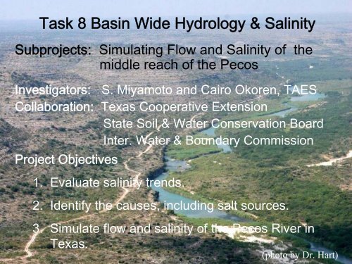
Task 8 <strong>Basin</strong> Wide Hydrology & Salinity<br />
Subprojects: Simulating Flow and Salinity of the<br />
middle reach of the Pecos<br />
Investigators: S. <strong>Miyamoto</strong> and Cairo Okoren, TAES<br />
Collaboration: <strong>Texas</strong> Cooperative Extension<br />
State Soil & Water Conservation Board<br />
Inter. Water & Boundary Commission<br />
Project Objectives<br />
1. Evaluate salinity trends.<br />
2. Identify the causes, including salt sources.<br />
3. Simulate flow and salinity of the Pecos River in<br />
<strong>Texas</strong>.<br />
1<br />
(photo by Dr. Hart)
The <strong>Rio</strong> <strong>Grande</strong> <strong>Basin</strong>s above Amistad<br />
1. The upper <strong>Rio</strong> <strong>Grande</strong><br />
<strong>Basin</strong> (Colorado, NM,<br />
West TX)<br />
2. The Pecos Sub-basin<br />
(New Mexico, West<br />
<strong>Texas</strong>)<br />
3. <strong>Rio</strong> Conchos Subbasin<br />
(old Mexico)<br />
2
Accomplishments:<br />
1. Tentatively identified geological sources of<br />
salts entering the Pecos River.<br />
RECONNAISSANCE SURVEY OF SALT SOURCES AND<br />
LOADING INTO THE PECOS RIVER<br />
Elephant Butte<br />
Reservoir<br />
Closed<br />
<strong>Basin</strong><br />
El Paso<br />
Chain Lake 261 K/tons per<br />
year<br />
Pecos<br />
River<br />
Malaga Bend 162<br />
Red Bluff<br />
G. Falls-Girvin 175<br />
S. <strong>Miyamoto</strong>, Fasong Yuan, and Shilpa Anand<br />
<strong>Texas</strong> A&M University Agricultural Research Center at El Paso<br />
<strong>Texas</strong> Agricultural Experiment Station<br />
In cooperation with<br />
Will Hatler and Alyson McDonald Gilbert Anaya and Wayne Belzer<br />
<strong>Texas</strong> Cooperative Extension International Boundary & Water<br />
at Fort Stockton Commission, U.S. Section<br />
Fort<br />
Quitman<br />
Girvin<br />
Ojinaga<br />
Presidio<br />
Foster Ranch<br />
Devil's<br />
River<br />
<strong>Rio</strong> Conchos<br />
Presa Luis Leon<br />
Amistad<br />
Reservoir<br />
Francisco I.<br />
Madero<br />
La Boquilla<br />
A Reconnaissance Report Submitted to<br />
<strong>Texas</strong> State Soil and Conservation Board and<br />
U.S. Environmental Protection Agency<br />
In Partial Fulfillment of<br />
A contract TSSWCB No. 04-11 and US EPA, No. 4280001<br />
TR - 291<br />
December 2005<br />
3
2. Identified main causes of salinity<br />
increase at Red Bluff.<br />
o<br />
o<br />
o<br />
Brine intrusion<br />
from geological<br />
formations<br />
Reduced flow and<br />
dilution<br />
High evaporation<br />
from shallow<br />
reservoir storage<br />
4
3. Evaluated the impact of tributary salt<br />
loading on salinity of Amistad Reservoir.<br />
1969 - 89<br />
Salt Flow<br />
Mt/y % Mm 3 /y %<br />
Conchos 0.76 (41) 909 (44)<br />
Pecos 0.54 (29) 274 (13)<br />
MRG 0.35 (19) 169 (8)<br />
Devils 0.19 (10) 711 (35)<br />
INFLUENCE OF TRIBUTARIES ON SALINITY OF<br />
AMISTAD INTERNATIONAL RESERVOIR<br />
S. <strong>Miyamoto</strong>, Fasong Yuan and Shilpa Anand<br />
<strong>Texas</strong> A&M University Agricultural Research Center at El Paso<br />
<strong>Texas</strong> Agricultural Experiment Station<br />
Since 1990, the flow and salt<br />
loading from <strong>Rio</strong> Conchos are<br />
down.<br />
An Investigatory Report Submitted to<br />
<strong>Texas</strong> State Soil and Water Conservation Board and<br />
U.S. Environmental Protection Agency<br />
In a partial fulfillment of 5<br />
A contract TSSWCB, No. 04-11 and US EPA, No. 4280001
4. Identified main causes of salinity increase<br />
at Amistad.<br />
1000<br />
o Salinity increased from<br />
560 to nearly 1000<br />
ppm in 1988, then<br />
1995<br />
Salinity, mg L -1<br />
800<br />
600<br />
a<br />
Flow-weighted<br />
Arithmetic<br />
8<br />
Salinity<br />
o 1988 surge : salt<br />
flushing from the MRG<br />
o 1995 surge: drought in<br />
<strong>Rio</strong> Conchos<br />
Inflow, bill m 3 /y<br />
400<br />
5.0 1952.00 b 1962.00 1972.00 1982.00 Storage 1992.00 2002.00<br />
4.0<br />
3.0<br />
2.0<br />
1.0<br />
0.0<br />
Inflow into Amistad<br />
1952 1962 1972 1982 1992 2002<br />
Year<br />
6
Salininization of Riparian Zones<br />
Providing salt storage,<br />
and release during bank<br />
overflow and vegetation<br />
transformation.<br />
Salt Balance, million ton year -1<br />
0.7<br />
0.6<br />
0.5<br />
0.4<br />
0.3<br />
0.2<br />
0.1<br />
0<br />
-0.1<br />
-0.2<br />
-0.3<br />
a<br />
Caballo-El P aso<br />
El P aso -P residio<br />
-0 4<br />
7
5. Develop a model to predict monthly<br />
salinity of outflow from inflow and storage<br />
data, and applied to Red Bluff.<br />
WATER BALANCE, SALT LOADING, AND SALINITY<br />
CONTROL OPTIONS OF RED BLUFF RESERVOIR, TEXAS<br />
S. <strong>Miyamoto</strong>, Fasong Yuan, and Shilpa Anand<br />
<strong>Texas</strong> A&M University Agricultural Research Center at El Paso<br />
<strong>Texas</strong> Agricultural Experiment Station<br />
and<br />
<strong>Texas</strong> Water Resources Institute<br />
The <strong>Texas</strong> A&M University System<br />
TR - 298<br />
8
Current Activities<br />
1. Flow and salt transport analyses<br />
Red Bluff and Girvin<br />
Type A<br />
Floodplain Stream<br />
Floodplain<br />
Base model: Routing<br />
model (ROTO) in SWAT<br />
Q B0<br />
Q E<br />
Q ET<br />
Modifications:<br />
Channel shape<br />
Interactions with G.W.<br />
Targets: Estimate of<br />
bank overflow and salinity<br />
Q P<br />
Type B<br />
Riparian Stream Riparian<br />
Q E<br />
Q B0 Q ET<br />
Q P<br />
9
2. Initiated riparian modeling.<br />
o<br />
Two-dimensional<br />
o<br />
Water balance<br />
o<br />
Salt balance<br />
o<br />
Impact of salinization<br />
on growth and ET of<br />
riparian vegetation.<br />
10
Potential Benefits<br />
1. Help develop salinity control strategies<br />
for the Pecos River and the <strong>Rio</strong><br />
<strong>Grande</strong> between El Paso to Amistad.<br />
2. Help assess the long-term water<br />
management strategies on salinity of<br />
the stream, the riparian zones, and<br />
Amistad Reservoir.<br />
11
Future Plan<br />
Continue with what we started.<br />
12