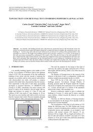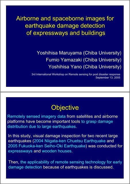
Objective
Objective
Objective

Create successful ePaper yourself
Turn your PDF publications into a flip-book with our unique Google optimized e-Paper software.
Airborne and spaceborne images for<br />
earthquake damage detection<br />
of expressways and buildings<br />
Yoshihisa Maruyama (Chiba University)<br />
Fumio Yamazaki (Chiba University)<br />
Yoshihisa Yano (Chiba University)<br />
3rd International Workshop on Remote sensing for post disaster response<br />
September 13, 2005<br />
<strong>Objective</strong><br />
Remotely sensed imagery data from satellites and airborne<br />
platforms have become important tools to grasp damage<br />
distribution due to large earthquakes.<br />
In this study, visual damage inspection for two recent large<br />
earthquakes (2004 Niigata-ken Chuetsu Earthquake and<br />
2005 Fukuoka-ken Seiho-Oki Earthquake) was conducted for<br />
expressways and wooden houses.<br />
Then, the applicability of remote sensing technology for early<br />
damage detection because of earthquakes is discussed.
Contents<br />
1. Niigata-ken Chuetsu Earthquake<br />
• Relationship between seismic intensity and damage of<br />
expressways<br />
• Damage detection of expressways using aerial<br />
photograph<br />
2. Fukuoka-ken Seiho-Oki Earthquake<br />
• Visual damage Inspection of wooden houses in<br />
Genkai-jima island using aerial photograph<br />
2004 Niigata-ken Chuetsu Earthquake<br />
October 23, 2004<br />
M JMA =6.8, M w =6.6<br />
Distribution of JMA Seismic Intensity (from JMA)
Damage of Expressways<br />
226.2 kp 226.7 kp<br />
217.3 kp 228.1 kp<br />
Estimation of the Distribution of<br />
JMA Seismic Intensity<br />
Kriging technique, a method of stochastic interpolation, is employed.<br />
184 ground motion records (K-NET: 132 stations, JH: 52 stations)<br />
Observed Value<br />
Estimated Value<br />
Ground Surface<br />
Deconvolution Convolution<br />
<br />
<br />
<br />
Interpolation by Kriging Technique<br />
Base Rock
Estimation of the Distribution of<br />
JMA Seismic Intensity<br />
Deconvolution of surface ground motions to (outcrop) base<br />
Soil Classification (Yamazaki et al., 2000)<br />
I<br />
bi<br />
=<br />
I<br />
si<br />
−<br />
ARI<br />
i<br />
ARI: amplification of<br />
JMA Seismic<br />
Intensity based on soil<br />
classification<br />
Estimation of the Distribution of<br />
JMA Seismic Intensity<br />
Kriging interpolation at base rock<br />
Attenuation Relation (Trend Component)<br />
Attenuation Relationship<br />
<br />
<br />
<br />
<br />
<br />
<br />
<br />
<br />
<br />
<br />
I = 9.014<br />
−1.89 log10 r − 0. 0085r<br />
<br />
<br />
<br />
<br />
<br />
<br />
Residual Component<br />
X<br />
Ii<br />
=<br />
I<br />
bi<br />
−<br />
I<br />
mi<br />
Interpolated by Kriging<br />
Technique
Estimated Distribution of JMA Seismic Intensity<br />
<br />
Convolution<br />
to Ground<br />
Surface<br />
Distribution of JMA Seismic Intensity<br />
along the Expressway
Relationship between the number of<br />
damages and JMA Seismic Intensity<br />
<br />
<br />
<br />
<br />
<br />
<br />
<br />
<br />
<br />
<br />
<br />
<br />
<br />
<br />
<br />
<br />
<br />
<br />
<br />
<br />
<br />
<br />
<br />
<br />
<br />
<br />
<br />
<br />
<br />
<br />
<br />
<br />
Damage Detection of Expressways<br />
using Aerial Photograph<br />
Aerial Photographs taken by Geographical Survey Institute<br />
Kanetsu<br />
Expressway<br />
Kawaguchi
Aerial Photograph taken by<br />
Geographical Survey Institute<br />
Damage Detection of Expressways<br />
using Aerial Photograph<br />
Echigo-Kawaguchi Interchange<br />
Horinouchi Interchange<br />
215.2 kp<br />
214.9 kp<br />
213.9 kp<br />
213.7 kp<br />
215.0 kp<br />
214.5 kp
213.7 kp<br />
Aerial Photo<br />
Field Photo<br />
Gap of road surface (20 cm)<br />
213.9 kp<br />
Aerial Photo<br />
Field Photo<br />
Gap of bridge joint<br />
Depression of road shoulder
214.9 kp<br />
Aerial Photo<br />
Field Photo<br />
Depression of road shoulder<br />
4 panels were fallen down<br />
215.2 kp<br />
Aerial Photo<br />
Field Photo<br />
Depression of road surface<br />
Aerial Photo<br />
Field Photo<br />
Gap of road surface
Damage detection based on images<br />
with various resolutions<br />
List of resolutions of satellite images<br />
Satellite<br />
QuickBird<br />
IKONOS<br />
SPOT-5<br />
Resolution<br />
60 cm<br />
100 cm<br />
250 cm<br />
Damage detection based on images<br />
with various resolutions<br />
214.5 kp<br />
Aerial Photo<br />
QuickBird60cm<br />
IKONOS100cm<br />
SPOT-5250cm
Damage detection based on images with<br />
various resolutions<br />
213.7 kp<br />
Aerial Photo<br />
QuickBird60cm<br />
IKONOS100cm<br />
SPOT-5250cm<br />
Damage detection based on images with<br />
various resolutions<br />
215.2 kp<br />
Aerial Photo<br />
QuickBird60cm<br />
IKONOS100cm<br />
SPOT-5250cm
Real-Time Earthquake Disaster Mitigation<br />
System for Expressway Network<br />
215.2 kp<br />
214.9 kp<br />
213.9 kp<br />
213.7 kp<br />
1.0<br />
<br />
215.0 kp<br />
214.5 kp<br />
0.8<br />
0.6<br />
0.4<br />
C<br />
B<br />
A<br />
0.2<br />
As<br />
0.0<br />
0 30 60 90 120 150<br />
Contents<br />
1. Niigata-ken Chuetsu Earthquake<br />
• Relationship between seismic intensity and damage of<br />
expressways<br />
• Damage detection of expressways using aerial<br />
photograph<br />
2. Fukuoka-ken Seiho-Oki Earthquake<br />
• Visual damage Inspection of wooden houses in<br />
Genkai-jima island using aerial photograph
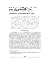
2005 Fukuoka-ken Seiho-Oki Earthquake<br />
March 20, 2005<br />
M JMA =7.0, M w =6.6<br />
Distribution of JMA Seismic<br />
Intensity (from JMA)<br />
Genkai-jima Island<br />
Field Survey (2005.04.25 and 05.01)<br />
Field photograph of each wooden<br />
house was taken.
Field Photographs<br />
Comparison between Satellite Image and<br />
Aerial Photograph<br />
Elementary School<br />
IKONOS Image<br />
Aerial Photo<br />
0m<br />
30m
Comparison between Satellite Image and<br />
Aerial Photograph<br />
Wooden Houses<br />
IKONOS Image<br />
Aerial Photo<br />
0m<br />
10m<br />
Classification of Damage to Wooden Houses<br />
Minor<br />
D0<br />
Okada and Takai, 1999<br />
Major<br />
D5
Diagonal<br />
Vertical<br />
Field Photo<br />
Diagonal<br />
Vertical<br />
Field Photo
Diagonal<br />
Vertical<br />
Field Photo<br />
Visual damage Inspection of wooden houses in<br />
Genkai-jima island using Aerial Photograph<br />
Damage Grade<br />
D0 ~ D2<br />
D3<br />
D4<br />
D5<br />
Sum<br />
Number<br />
79<br />
113<br />
8<br />
18<br />
218
Conclusions<br />
Using aerial photographs, visual damage interpretation<br />
was conducted for two recent large earthquakes.<br />
The result of photo interpretation was compared with the<br />
ground truth data, and our visual damage inspection seems<br />
to give reasonable accuracy.<br />
The remote sensing technology can be used for the<br />
detection of damage because of large earthquakes.<br />
Combining the spatial distribution of seismic intensity with<br />
the remotely sensed image, proper emergency response to<br />
earthquake disaster can be conducted.<br />
Thank you very much!