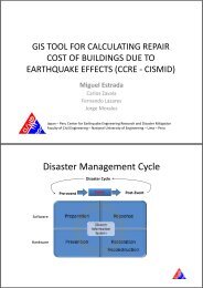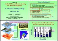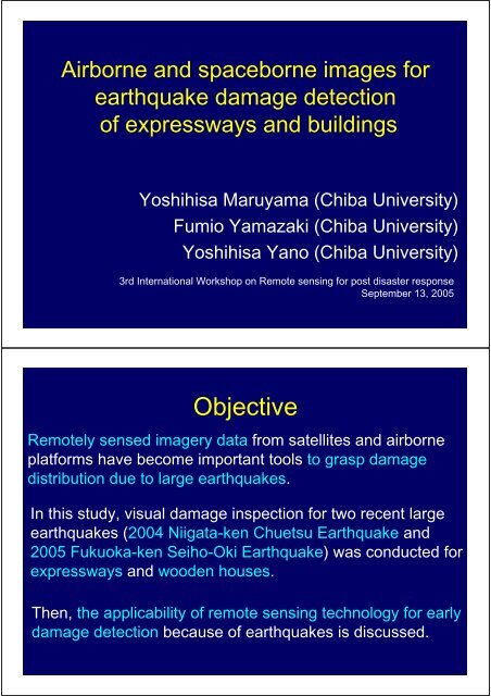
Objective
Objective
Objective

You also want an ePaper? Increase the reach of your titles
YUMPU automatically turns print PDFs into web optimized ePapers that Google loves.
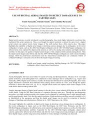
Airborne and spaceborne images for<br />
earthquake damage detection<br />
of expressways and buildings<br />
Yoshihisa Maruyama (Chiba University)<br />
Fumio Yamazaki (Chiba University)<br />
Yoshihisa Yano (Chiba University)<br />
3rd International Workshop on Remote sensing for post disaster response<br />
September 13, 2005<br />
<strong>Objective</strong><br />
Remotely sensed imagery data from satellites and airborne<br />
platforms have become important tools to grasp damage<br />
distribution due to large earthquakes.<br />
In this study, visual damage inspection for two recent large<br />
earthquakes (2004 Niigata-ken Chuetsu Earthquake and<br />
2005 Fukuoka-ken Seiho-Oki Earthquake) was conducted for<br />
expressways and wooden houses.<br />
Then, the applicability of remote sensing technology for early<br />
damage detection because of earthquakes is discussed.
Contents<br />
1. Niigata-ken Chuetsu Earthquake<br />
• Relationship between seismic intensity and damage of<br />
expressways<br />
• Damage detection of expressways using aerial<br />
photograph<br />
2. Fukuoka-ken Seiho-Oki Earthquake<br />
• Visual damage Inspection of wooden houses in<br />
Genkai-jima island using aerial photograph<br />
2004 Niigata-ken Chuetsu Earthquake<br />
October 23, 2004<br />
M JMA =6.8, M w =6.6<br />
Distribution of JMA Seismic Intensity (from JMA)
Damage of Expressways<br />
226.2 kp 226.7 kp<br />
217.3 kp 228.1 kp<br />
Estimation of the Distribution of<br />
JMA Seismic Intensity<br />
Kriging technique, a method of stochastic interpolation, is employed.<br />
184 ground motion records (K-NET: 132 stations, JH: 52 stations)<br />
Observed Value<br />
Estimated Value<br />
Ground Surface<br />
Deconvolution Convolution<br />
<br />
<br />
<br />
Interpolation by Kriging Technique<br />
Base Rock
Estimation of the Distribution of<br />
JMA Seismic Intensity<br />
Deconvolution of surface ground motions to (outcrop) base<br />
Soil Classification (Yamazaki et al., 2000)<br />
I<br />
bi<br />
=<br />
I<br />
si<br />
−<br />
ARI<br />
i<br />
ARI: amplification of<br />
JMA Seismic<br />
Intensity based on soil<br />
classification<br />
Estimation of the Distribution of<br />
JMA Seismic Intensity<br />
Kriging interpolation at base rock<br />
Attenuation Relation (Trend Component)<br />
Attenuation Relationship<br />
<br />
<br />
<br />
<br />
<br />
<br />
<br />
<br />
<br />
<br />
I = 9.014<br />
−1.89 log10 r − 0. 0085r<br />
<br />
<br />
<br />
<br />
<br />
<br />
Residual Component<br />
X<br />
Ii<br />
=<br />
I<br />
bi<br />
−<br />
I<br />
mi<br />
Interpolated by Kriging<br />
Technique
Estimated Distribution of JMA Seismic Intensity<br />
<br />
Convolution<br />
to Ground<br />
Surface<br />
Distribution of JMA Seismic Intensity<br />
along the Expressway
Relationship between the number of<br />
damages and JMA Seismic Intensity<br />
<br />
<br />
<br />
<br />
<br />
<br />
<br />
<br />
<br />
<br />
<br />
<br />
<br />
<br />
<br />
<br />
<br />
<br />
<br />
<br />
<br />
<br />
<br />
<br />
<br />
<br />
<br />
<br />
<br />
<br />
<br />
<br />
Damage Detection of Expressways<br />
using Aerial Photograph<br />
Aerial Photographs taken by Geographical Survey Institute<br />
Kanetsu<br />
Expressway<br />
Kawaguchi
Aerial Photograph taken by<br />
Geographical Survey Institute<br />
Damage Detection of Expressways<br />
using Aerial Photograph<br />
Echigo-Kawaguchi Interchange<br />
Horinouchi Interchange<br />
215.2 kp<br />
214.9 kp<br />
213.9 kp<br />
213.7 kp<br />
215.0 kp<br />
214.5 kp
213.7 kp<br />
Aerial Photo<br />
Field Photo<br />
Gap of road surface (20 cm)<br />
213.9 kp<br />
Aerial Photo<br />
Field Photo<br />
Gap of bridge joint<br />
Depression of road shoulder
214.9 kp<br />
Aerial Photo<br />
Field Photo<br />
Depression of road shoulder<br />
4 panels were fallen down<br />
215.2 kp<br />
Aerial Photo<br />
Field Photo<br />
Depression of road surface<br />
Aerial Photo<br />
Field Photo<br />
Gap of road surface
Damage detection based on images<br />
with various resolutions<br />
List of resolutions of satellite images<br />
Satellite<br />
QuickBird<br />
IKONOS<br />
SPOT-5<br />
Resolution<br />
60 cm<br />
100 cm<br />
250 cm<br />
Damage detection based on images<br />
with various resolutions<br />
214.5 kp<br />
Aerial Photo<br />
QuickBird60cm<br />
IKONOS100cm<br />
SPOT-5250cm
Damage detection based on images with<br />
various resolutions<br />
213.7 kp<br />
Aerial Photo<br />
QuickBird60cm<br />
IKONOS100cm<br />
SPOT-5250cm<br />
Damage detection based on images with<br />
various resolutions<br />
215.2 kp<br />
Aerial Photo<br />
QuickBird60cm<br />
IKONOS100cm<br />
SPOT-5250cm
Real-Time Earthquake Disaster Mitigation<br />
System for Expressway Network<br />
215.2 kp<br />
214.9 kp<br />
213.9 kp<br />
213.7 kp<br />
1.0<br />
<br />
215.0 kp<br />
214.5 kp<br />
0.8<br />
0.6<br />
0.4<br />
C<br />
B<br />
A<br />
0.2<br />
As<br />
0.0<br />
0 30 60 90 120 150<br />
Contents<br />
1. Niigata-ken Chuetsu Earthquake<br />
• Relationship between seismic intensity and damage of<br />
expressways<br />
• Damage detection of expressways using aerial<br />
photograph<br />
2. Fukuoka-ken Seiho-Oki Earthquake<br />
• Visual damage Inspection of wooden houses in<br />
Genkai-jima island using aerial photograph
2005 Fukuoka-ken Seiho-Oki Earthquake<br />
March 20, 2005<br />
M JMA =7.0, M w =6.6<br />
Distribution of JMA Seismic<br />
Intensity (from JMA)<br />
Genkai-jima Island<br />
Field Survey (2005.04.25 and 05.01)<br />
Field photograph of each wooden<br />
house was taken.
Field Photographs<br />
Comparison between Satellite Image and<br />
Aerial Photograph<br />
Elementary School<br />
IKONOS Image<br />
Aerial Photo<br />
0m<br />
30m
Comparison between Satellite Image and<br />
Aerial Photograph<br />
Wooden Houses<br />
IKONOS Image<br />
Aerial Photo<br />
0m<br />
10m<br />
Classification of Damage to Wooden Houses<br />
Minor<br />
D0<br />
Okada and Takai, 1999<br />
Major<br />
D5
Diagonal<br />
Vertical<br />
Field Photo<br />
Diagonal<br />
Vertical<br />
Field Photo
Diagonal<br />
Vertical<br />
Field Photo<br />
Visual damage Inspection of wooden houses in<br />
Genkai-jima island using Aerial Photograph<br />
Damage Grade<br />
D0 ~ D2<br />
D3<br />
D4<br />
D5<br />
Sum<br />
Number<br />
79<br />
113<br />
8<br />
18<br />
218
Conclusions<br />
Using aerial photographs, visual damage interpretation<br />
was conducted for two recent large earthquakes.<br />
The result of photo interpretation was compared with the<br />
ground truth data, and our visual damage inspection seems<br />
to give reasonable accuracy.<br />
The remote sensing technology can be used for the<br />
detection of damage because of large earthquakes.<br />
Combining the spatial distribution of seismic intensity with<br />
the remotely sensed image, proper emergency response to<br />
earthquake disaster can be conducted.<br />
Thank you very much!