Draft Environmental Impact Report (1431 KB pdf file) - BolandEnviro ...
Draft Environmental Impact Report (1431 KB pdf file) - BolandEnviro ...
Draft Environmental Impact Report (1431 KB pdf file) - BolandEnviro ...

You also want an ePaper? Increase the reach of your titles
YUMPU automatically turns print PDFs into web optimized ePapers that Google loves.
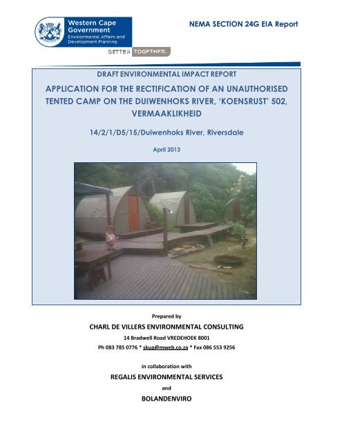
NEMA SECTION 24G EIA <strong>Report</strong><br />
DRAFT ENVIRONMENTAL IMPACT REPORT<br />
APPLICATION FOR THE RECTIFICATION OF AN UNAUTHORISED<br />
TENTED CAMP ON THE DUIWENHOKS RIVER, ‘KOENSRUST’ 502,<br />
VERMAAKLIKHEID<br />
14/2/1/D5/15/Duiwenhoks River, Riversdale<br />
April 2013<br />
Prepared by<br />
CHARL DE VILLERS ENVIRONMENTAL CONSULTING<br />
14 Bradwell Road VREDEHOEK 8001<br />
Ph 083 785 0776 * skua@mweb.co.za * Fax 086 553 9256<br />
in collaboration with<br />
REGALIS ENVIRONMENTAL SERVICES<br />
and<br />
BOLANDENVIRO
NEMA SECTION 24G EIA REPORT<br />
Contents:<br />
Section A:<br />
Activity Information<br />
Section B:<br />
Description of Receiving Environment<br />
Section C:<br />
Public Participation Information<br />
Section D:<br />
Need and Desirability<br />
Section E:<br />
Alternatives<br />
Section F:<br />
Preliminary <strong>Impact</strong> Assessment, Management, Mitigation and Monitoring<br />
Section G:<br />
Assessment Methodologies and Criteria, Gaps in Knowledge, under laying<br />
Assumptions and Uncertainties<br />
Section H:<br />
Recommendations of the EAP<br />
Section I:<br />
Motivation for response to an emergency<br />
Section J:<br />
Appendices<br />
S24GEIAR/07/2012 2
NEMA SECTION 24G EIA REPORT<br />
Kindly note that:<br />
1. This section 24G <strong>Environmental</strong> <strong>Impact</strong> Assessment (”EIA”) report must be completed for all section<br />
24G applications in terms of the above Acts, by an independent <strong>Environmental</strong> Assessment<br />
Practitioner (“EAP”).<br />
2. This EIA report is current as of July 2012. It is the responsibility of the Applicant/EAP to ascertain<br />
whether subsequent versions of the EIA report have been published or produced by the<br />
competent authority.<br />
3. An Independent EAP must be appointed to complete the section 24G EIA report on behalf of the<br />
applicant; the declaration of independence must be completed by the independent EAP and<br />
submitted with this EIA report. If a specialist report is required, the specialist will also be required to<br />
complete the declaration of independence.<br />
4. Two hard copies and one electronic copy (CD/DVD) of this report must be submitted.<br />
5. The required information must be typed within the spaces provided. The sizes of the spaces<br />
provided are not necessarily indicative of the amount of information to be provided. The space<br />
provided extend as each space is filled with typing. A legible font type and size must be used when<br />
completing the report. The font size should not be smaller than 10pt (e.g. Century Gothic 10). A<br />
digital copy of the Section EIA <strong>Report</strong> is available on the Department’s website (details below).<br />
6. The use of “Not applicable” in the EIA report must be done with circumspection.<br />
7. No faxed or e-mailed EIA reports will be accepted.<br />
8. Unless protected by law, all information contained in and attached to this EIA report will become<br />
public information on receipt by the competent authority. Upon request, any Interested and<br />
Affected Party (“I&AP”) should be provided with the information contained in and attached to this<br />
EIA report. During any stage of the application process, the information contained in and attached<br />
to it must be provided by the applicant / EAP.<br />
9. This EIA report must be submitted to the Department at the postal address given below or by<br />
delivery thereof to the Registry Office of the Department. Unnecessary delays will be incurred<br />
should the application and attached information not be submitted to the correct address.<br />
S24GEIAR/07/2012 3
NEMA SECTION 24G EIA REPORT<br />
10. PROCESS TO BE FOLLOWED:<br />
a) A section 24G Application Form constitutes the initiation of the Section 24G application<br />
process. If you have failed to submit an application form, you may not proceed with the<br />
compilation and submission of this EIA report until such time that a section 24G application<br />
form has been submitted to the Department and subsequently acknowledged.<br />
b) Once the information requirements in respect of the application have been met, a draft EIA<br />
report, which must include an <strong>Environmental</strong> Management Programme (“EMP”), must first be<br />
made available to the I&APs, including all the relevant State Departments that administer<br />
laws relating to a matter affecting the environment, for comment for a period of 40 (forty)<br />
calendar days. Unless otherwise indicated by the Department, a commenting period of at<br />
least 21 (twenty-one) days must be provided to I&APs, including the relevant State<br />
Departments, to comment on any additional information, documentation or reports<br />
(including the final EIR), other than the draft EIR.<br />
c) The draft EIA report must be submitted to the Department in order to meet the requirements<br />
of section 24O of the NEMA. The Department will notify the State Departments of the 40 (forty)<br />
day commenting after receipt of the draft EIA report.<br />
d) Upon submission of the final EIA report, the competent authority will reconsider the application<br />
and may undertake a site inspection or request such additional information as the competent<br />
authority may require from the Applicant/EAP.<br />
e) The Department will consider the final EIA report/additional information (if required) to<br />
determine the administrative fine (not exceeding R1 million) and inform the applicant<br />
accordingly. The fine must be paid within 60 days from the date of the fine notice. The<br />
applicant is required to provide proof of payment of the fine to the Department.<br />
f) In accordance with section 24G(2), the competent authority will then:<br />
• direct the applicant to cease the activity, either wholly or in part, and to rehabilitate the<br />
environment within such time and subject to such conditions as the Department may<br />
deem necessary; or<br />
• issue an environmental authorisation to the applicant subject to such conditions as the<br />
Department may deem necessary.<br />
11. Note, failure to comply with a directive calling for information to be submitted within a specified<br />
period may result in the institution of appropriate legal action as is deemed necessary by this<br />
Department and as provided for in the legislation.<br />
12. A person failing to comply with a directive or contravening or failing to comply with a condition of<br />
environmental authorisation is guilty of an offence and is liable on conviction to a penalty of a fine<br />
not exceeding R5 million or to imprisonment for a period not exceeding ten years, or to both such<br />
fine and such imprisonment.<br />
S24GEIAR/07/2012 4
NEMA SECTION 24G EIA REPORT<br />
DEPARTMENTAL DETAILS<br />
DEPARTMENTAL REFERENCE NUMBER(S) (for official use)<br />
Department of <strong>Environmental</strong> Affairs<br />
and Development Planning,<br />
Directorate: <strong>Environmental</strong><br />
Compliance & Enforcement,<br />
Attention: Sub-directorate:<br />
Section 24G Applications<br />
Private Bag X9086<br />
Cape Town, 8000<br />
Registry Office<br />
1 st Floor Utilitas Building<br />
1 Dorp Street, Cape Town<br />
Queries should be directed to the<br />
Sub-directorate: Section 24G<br />
Applications at:<br />
Tel: (021) 483-8019<br />
Fax: (021) 483-4033<br />
File Reference number<br />
(S24G)<br />
File Reference number<br />
(Enforcement), if applicable<br />
File reference number (EIA),<br />
if applicable:<br />
File reference number<br />
(Waste), if applicable:<br />
File reference number<br />
(Other):<br />
ENV number:<br />
14/2/1/D5/15/Duiwenhoks<br />
River, Riversdale<br />
DETAILS OF THE APPLICANT<br />
Applicant Name: Koensrust Plase (Pty)Ltd<br />
Contact Person Dr Francois du Plessis<br />
RSA ID number 561213 5016 084<br />
Trading name Koensrust Plase (Pty)Ltd<br />
Company reg no 1981/006147/07<br />
Postal address: c/o Norman, Wirth and Stephens, 2 nd floor, 50 Keerom Street<br />
CAPE TOWN Postal code: 8001<br />
Telephone: (021) 461 6692 Cell: 082 825 5210<br />
E-mail: francois@dupmail.com Fax: (021) 461 6693<br />
DETAILS OF THE ENVIRONMENTAL ASSESSMENT PRACTITIONER (EAP)<br />
<strong>Environmental</strong><br />
Assessment Practitioner:<br />
Charl de Villiers <strong>Environmental</strong> Consulting<br />
Contact person:<br />
Charl de Villiers<br />
Postal address:<br />
14 Bradwell Road, VREDEHOEK<br />
Postal code: 8001<br />
Telephone: ( 021) 461 2477 Cell: 083 785 0776<br />
E-mail: skua@mweb.co.za Fax: (086) 553 9256<br />
EAP Qualifications BA Hons; MPhil <strong>Environmental</strong> Management<br />
EAP<br />
Registrations/Associations<br />
Certified <strong>Environmental</strong> Assessment Practitioner (EAPSA)<br />
S24GEIAR/07/2012 5
NEMA SECTION 24G EIA REPORT<br />
SECTION A: ACTIVITY INFORMATION<br />
1. PROJECT TITLE<br />
RECTIFICATION OF UNAUTHORISED TENTED CAMP ON THE DUIWENHOKS RIVER, ‘KOENSRUST’ 502,<br />
VERMAAKLIKHEID<br />
2. ACTIVITY DESCRIPTION<br />
(Cross out the appropriate box “⌧” and provide a description where required).<br />
(a)<br />
Is/are the activity(ies) complete or is/are the activity(ies)<br />
still to be completed Completed Incomplete<br />
All work relating to the construction of the tented camp had been completed by November 2011.<br />
(b) Is/was the project a new development or an upgrade of an<br />
existing development Also indicate the date (e.g. 2 August<br />
2010) when the activity commenced as well as the original date<br />
New Upgrade<br />
of commencement if the application is an upgrade.<br />
The activities in question commenced in September 2010. They entailed adding wooden decks and<br />
three canvas tents to an existing shed on the site that was erected in the 1990s.<br />
S24GEIAR/07/2012 6
NEMA SECTION 24G EIA REPORT<br />
(c) Clearly describe the activity and associated infrastructure commenced with, indicating what<br />
has been completed and what still has to be completed. See Appendix B (Site plan) and<br />
Appendix C (Photographs).<br />
The unauthorised works that are the subject of this application commenced in September 2010 and<br />
were concluded in November the next year.<br />
In summary, the activities entailed clearing about 250 m 2 of vegetation to establish a tented camp<br />
on private land next to the Duiwenhoks River 5 km downstream of Vermaaklikheid in the Hessequa<br />
Municipality, Western Cape (Fig 1). The camp, which forms an integrated unit with the existing<br />
wooden shed on the site, comprises 127 m 2 of wooden decking that supports three permanently<br />
pitched canvas safari tents arranged in a row to the south. The deck houses an open ‘braai’ area<br />
just south of the shed.<br />
The tents are equipped with basic furnishings. There are four single beds in the tent closest to the<br />
shed, and a double bed in each of the remaining tents. This additional infrastructure covers an area<br />
of roughly 300 m 2 in extent. There is another sunken ‘braai’ place on the ground to the west of the<br />
decking.<br />
(d) Please provide details of all components of the activity and attach diagrams (e.g. architectural<br />
drawings or perspectives, engineering drawings, process flow charts etc.).<br />
Buildings YES NO<br />
Provide brief description:<br />
See above for a description of the tented camp. No permanent buildings (i.e. rigid, walled<br />
structures with roofs) were erected.<br />
Infrastructure (e.g. roads, power and water supply/ storage) YES NO<br />
Provide brief description:<br />
A wooden deck, 127 m 2 in extent, comprises the only infrastructure besides the three tents.<br />
Processing activities (e.g. manufacturing, storage, distribution) YES NO<br />
Provide brief description:<br />
Not applicable.<br />
Storage facilities for raw materials and products (e.g. volume and substances to be stored)<br />
Provide brief description YES NO<br />
Not applicable.<br />
Storage and treatment facilities for solid waste and effluent<br />
generated by the project<br />
Yes<br />
NO<br />
Provide brief description<br />
Not applicable.<br />
(e) Other activities (e.g. water abstraction activities, crop planting<br />
activities)<br />
Provide brief description<br />
Not applicable.<br />
Yes<br />
NO<br />
3. PHYSICAL SIZE OF THE ACTIVITY<br />
Indicate the physical spatial size of the activity as well as associated infrastructure<br />
300 m<br />
(footprints):<br />
2<br />
Indicate the area that has been transformed / cleared to allow for the activity as<br />
≤250<br />
well as associated infrastructure<br />
Total area: 300 m 2<br />
m 2<br />
S24GEIAR/07/2012 7
NEMA SECTION 24G EIA REPORT<br />
4. SITE ACCESS<br />
Was there an existing access road YES NO<br />
If NO, what was the distance over which the new access road was built Not<br />
applicable.<br />
m<br />
Describe the type of access road constructed:<br />
The only vehicular access to the ‘Koensrust’ tented camp is via a very steep jeep track that was<br />
constructed in the 1990s and later hardened on CapeNature’s instruction. This work was completed<br />
before the expiry of the Record of Decsion (30 September 2000) which authorised the upgrade of the<br />
track. The track drops 173 m over 1.6 km and has an average gradient of 10.6%. It can only be<br />
negotiated by four-wheel drive vehicles. The location of the track and an elevation graph are<br />
included with the site plan in Appendix B.<br />
5. SITE PHOTOGRAPHS<br />
Colour photographs of the site and its surroundings (taken of the site and from the site), both before (if<br />
available) and after the activity commenced, with a description of each photograph, must be<br />
attached to this application. The vantage points from which the photographs were taken must be<br />
indicated on the site plan, or locality plan as applicable. If available, please also provide past and<br />
recent aerial photographs. It should be supplemented with additional photographs of relevant<br />
features on the site. Date and source of photographs must be included. Photographs must be<br />
attached as an appendix to this form.<br />
6. APPLICABLE LEGISLATION, POLICIES AND/OR GUIDELINES<br />
Please list all legislation, policies and/or guidelines that were or are relevant to this activity.<br />
TYPE<br />
DATE<br />
LEGISLATION<br />
ADMINISTERING<br />
AUTHORITY<br />
Permit/ license/<br />
(if already<br />
authorization/comment<br />
obtained):<br />
National <strong>Environmental</strong><br />
Management Act (107<br />
of 1998) (NEMA), as<br />
amended<br />
Department of <strong>Environmental</strong><br />
Affairs & Development<br />
Planning (DEA&DP)<br />
<strong>Environmental</strong> Authorisation (in this<br />
case, in terms of s 24G)<br />
EIA Regulations 2010<br />
promulgated in terms of<br />
Section 24(5) of NEMA<br />
as amended<br />
DEA&DP<br />
<strong>Environmental</strong> Authorisation<br />
Land Use Planning<br />
Ordinance 15 of 1985<br />
Hessequa Municipality<br />
Application for departure i.t.o. s 15 of<br />
LUPO (pending)<br />
Environment<br />
Conservation Act 73 of<br />
1989<br />
Department of <strong>Environmental</strong><br />
Affairs & Development<br />
Planning (DEA&DP)<br />
<strong>Environmental</strong> authorisation of jetty,<br />
slipway and access track – reference<br />
25/4/100(2886). See Appendix E.<br />
30 September 1998<br />
EIA regulations<br />
published i.t.o. ECA<br />
DEA&DP<br />
As above<br />
73/1989<br />
S24GEIAR/07/2012 8
NEMA SECTION 24G EIA REPORT<br />
POLICY/ GUIDELINES<br />
ADMINISTERING AUTHORITY<br />
Guideline on interpretation of listed activities (June 2010)<br />
Guideline on public participation (October 2011)<br />
Guideline on alternatives (October 2011)<br />
Guidelines for involving specialists in EIA processes (2005)<br />
Guideline on need and desirability (October 2011)<br />
Biodiversity Sector Plan for the Mossel Bay and Hessequa Municipalities<br />
(2010).<br />
W Cape PSDF: Rural land-use planning and management guidelines<br />
(2009)<br />
Dept of <strong>Environmental</strong> Affairs (DEA)<br />
DEA&DP<br />
DEA&DP<br />
DEA&DP<br />
DEA&DP<br />
DEA&DP/CapeNature<br />
DEA&DP<br />
S24GEIAR/07/2012 9
NEMA SECTION 24G EIA REPORT<br />
SECTION B: DESCRIPTION OF RECEIVING ENVIRONMENT<br />
Site/Area Description<br />
For linear activities (pipelines, etc.) as well as activities that cover very large sites, it may be necessary<br />
to complete copies of this section for each part of the site that has a significantly different<br />
environment. In such cases please complete copies of Section C and indicate the area which is<br />
covered by each copy No. on the site plan.<br />
Section C Copy No. (e.g. 1,<br />
2, or 3):<br />
N/A<br />
1. GRADIENT OF THE SITE<br />
Indicate the general gradient of the site(s) (cross out the appropriate box).<br />
Flat Flatter than 1:10 1:10 – 1:5 Steeper than 1:5<br />
2. LOCATION IN LANDSCAPE<br />
Indicate the landform(s) that best describes the site (cross out (“⌧”) the appropriate box(es).<br />
Ridgeline<br />
Plateau<br />
Side slope of<br />
hill/mountain<br />
Closed<br />
valley<br />
Open<br />
valley<br />
Plain<br />
Undulating<br />
plain/low<br />
hills<br />
Dune<br />
Seafront<br />
Other<br />
If other, please describe<br />
The tented camp is located at the base of one of several steep valleys that incise the limestone<br />
escarpment directly east of the Duiwenhoks River between the feature known as ‘Die Hoek’ and the<br />
mouth of the estuary at Puntjie. The Duiwenhoks River lies directly to the west of the limestone scarp<br />
below which the tented camp is located. The scarp drops steeply to the river, from an altitude of<br />
about 160 masl over a distance of a kilometre to virtually sea level in the channel of the Duiwenhoks<br />
River. The tented camp is located on a narrow raised bench, about 20 m wide, between the base<br />
of the scarp and the salt flats of the river. The access track and grassed area lie to the north-east.<br />
3. GROUNDWATER, SOIL AND GEOLOGICAL STABILITY OF THE SITE<br />
3.1 GROUNDWATER, SOIL AND GEOLOGICAL STABILITY OF THE SITE (PRE-COMMENCEMENT)<br />
Is the site(s) located on or near any of the following (cross out (“⌧”) the appropriate boxes)<br />
Shallow water table (less than 1.5m deep) YES NO UNSURE<br />
Seasonally wet soils (often close to water bodies) YES NO UNSURE<br />
Unstable rocky slopes or steep slopes with loose soil YES NO UNSURE<br />
Dispersive soils (soils that dissolve in water) YES NO UNSURE<br />
Soils with high clay content YES NO UNSURE<br />
Any other unstable soil or geological feature YES NO UNSURE<br />
An area sensitive to erosion YES NO UNSURE<br />
S24GEIAR/07/2012 10
NEMA SECTION 24G EIA REPORT<br />
3.2 GROUNDWATER, SOIL AND GEOLOGICAL STABILITY OF THE SITE (POST-COMMENCEMENT)<br />
Shallow water table (less than 1.5m deep) YES NO UNSURE<br />
Seasonally wet soils (often close to water bodies) YES NO UNSURE<br />
Unstable rocky slopes or steep slopes with loose soil YES NO UNSURE<br />
Dispersive soils (soils that dissolve in water) YES NO UNSURE<br />
Soils with high clay content YES NO UNSURE<br />
Any other unstable soil or geological feature YES NO UNSURE<br />
An area sensitive to erosion YES NO UNSURE<br />
If any of the answers to the above are “YES” or “unsure”, specialist input may be requested by the<br />
Department.<br />
(Information in respect of the above will often be available at the planning sections of local authorities.<br />
Where it does not exist, the 1:50 000 scale Regional Geotechnical Maps prepared by Geological<br />
Survey may also be used).<br />
4. SURFACE WATER<br />
4.1 SURFACE WATER (PRE-COMMENCEMENT)<br />
Indicate the surface water present on and or adjacent to the site and alternative sites (cross out (“⌧”)<br />
the appropriate boxes)<br />
Perennial River YES NO UNSURE<br />
Non-Perennial River YES NO UNSURE<br />
Permanent Wetland YES NO UNSURE<br />
Seasonal Wetland YES NO UNSURE<br />
Artificial Wetland YES NO UNSURE<br />
Estuarine / Lagoonal wetland YES NO UNSURE<br />
4.2 SURFACE WATER (POST-COMMENCEMENT)<br />
Indicate the surface water present on and or adjacent to the site and alternative sites (cross out (“⌧”)<br />
the appropriate boxes)<br />
Perennial River YES NO UNSURE<br />
Non-Perennial River YES NO UNSURE<br />
Permanent Wetland YES NO UNSURE<br />
Seasonal Wetland YES NO UNSURE<br />
Artificial Wetland YES NO UNSURE<br />
Estuarine / Lagoonal wetland YES NO UNSURE<br />
S24GEIAR/07/2012 11
NEMA SECTION 24G EIA REPORT<br />
5. VEGETATION AND/OR GROUNDCOVER<br />
Please note: The Department may request specialist input/studies depending on the nature of the<br />
biodiversity occurring on the site and potential impact(s) of the activity/ies. To assist with the<br />
identification of the biodiversity occurring on site and the ecosystem status consult http://bgis.sanbi.org<br />
or BGIShelp@sanbi.org. Information is also available on compact disc (“cd”) from the Biodiversity-GIS<br />
Unit, Ph (021) 799 8698. This information may be updated from time to time and it is the applicant/<br />
EAP’s responsibility to ensure that the latest version is used. A map of the relevant biodiversity<br />
information (including an indication of the habitat conditions as per (b) below) and must be provided<br />
as an overlay map to the property/site plan as an appendix to this form.<br />
5.1 VEGETATION AND/OR GROUNDCOVER (PRE-COMMENCEMENT)<br />
Cross out (“⌧”) the block and describe (where applicable) the vegetation types / groundcover<br />
present on the site before commencement of the activity.<br />
Indigenous Vegetation -<br />
good condition – See<br />
below.<br />
YES<br />
Indigenous Vegetation<br />
with scattered aliens<br />
NO<br />
Indigenous Vegetation with<br />
heavy alien infestation<br />
NO<br />
NOTE The following section only reports on habitat and vegetation-related features that are actually<br />
present at the ‘Koensrust’ tented camp, which therefore excludes phenomena such as are soil, sports<br />
fields and paved surfaces.<br />
Vegetation types present prior to commencement<br />
The fine-scale vegetation map for the Riversdale conservation planning domain (Vlok and De<br />
Villiers, 2007; Maree and Vromans, 2010) indicates that a thicket-fynbos mosaic occurs in the area,<br />
namely Vermaaklikheid Thicket-Limestone Fynbos. The tented camp is exclusively located in a<br />
thicket clump (i.e. the fynbos element of this vegetation type is not locally present).<br />
The Vegetation Map for South Africa, Lesotho and Swaziland (Mucina et al., (eds), 2005), which<br />
depicts vegetation types at a much smaller scale (1:1 000 000) than the 1:50 000 biodiversity sector<br />
plan for the Mossel Bay and Hessequa municipalites (Maree and Vromans, 2010), places the site on<br />
a boundary between Eastern Rûens Shale Renosterveld and Cape Coastal Lagoons.<br />
Ground-truthing by the botanical specialist, Jan Vlok, found that the national vegetation map had,<br />
in fact, erred and that the site did not support renosterveld, but the aforementioned thicket-fynbos<br />
mosaic (see the botanical assessment, Appendix G, as well as photographs in Appendix C of the<br />
habitat and vegetation that occur at the site). The immediate environs of the site that was used to<br />
develop the tented camp would have comprised, at most, about 1 350 m 2 of the thicket-limestone<br />
fynbos vegetation type. The developable area is probably considerably less than this owing to the<br />
proximity of the river and a steep slope directly to the south.<br />
The camp is situated about 10 or 12 m from the edge of salt marsh component of the Duiwenhoks<br />
River estuarine wetland. The National Water Act 36 of 1998 (section 1, ‘Definitions’) defines an<br />
‘estuary’ as a “partially or fully enclosed body of water... which is open to the sea permanently or<br />
periodically... and within which the sea water can be diluted, to an extent that is measurable, with<br />
fresh water drained from land....” The tented camp is located above the terrestrial margin of the salt<br />
marsh, in a fynbos-thicket mosaic; No activities therefore took place in an estuary as defined above.<br />
S24GEIAR/07/2012 12
NEMA SECTION 24G EIA REPORT<br />
Ecosystem status of affected vegetation<br />
Eastern Rûens Shale Renosterveld is classified as Critically Endangered and Cape Coastal Lagoons<br />
as not threatened by the national list of threatened ecosystems and ecosystems in need of<br />
protection (DEA, 2011). This list has been gazetted in terms of section 52 of the NEM: Biodiversity Act<br />
10 of 2004 and may therefore serve as a formal trigger for an application for environmental<br />
authorisation in terms of Listing Notice 3 of the 2010 NEMA EIA regulations.<br />
However, as previously noted, the national vegetation map edited by Mucina et al. (2005) has<br />
incorrectly depicted the site as supporting renosterveld whereas, in fact, it supports a matrix of<br />
limestone fynbos interspersed with discreet clumps of thicket. Neither of the vegetation units that<br />
comprise this mosaic is threatened (Vlok 2013, Appendix G). Also see the <strong>Draft</strong> EMP, Appendix H, for<br />
excerpts from the respective vegetation maps that support the conclusions of the botanist.<br />
The ‘Koensrust’ tented camp is located exclusively in the thicket component of the Vermaaklikheid<br />
Thicket-Limestone Fynbos mosaic, which is not threatened.<br />
Ecological corridors and soil boundaries<br />
The tented camp is located on the left bank of the Duiwenhoks River, about 5 km upstream from the<br />
estuary. The river, tidal wetlands and riparian vegetation would form part of an important subregional<br />
ecological corridor.<br />
Cultivated land<br />
There is a grassed area of some 2 300 m 2 which lies directly to the north of the shed on the site. This<br />
lawn, which slopes relatively gently towards the river, is bounded by a kloof at its upper end which<br />
contains an old earth dam that captures spring water from a local seep emerging from the<br />
surrounding limestone. It is believe that this area may have been previously planted with<br />
vegetables, which would explain the presence of the dam.<br />
Building or other structure<br />
The wooden, single-storey shed on the site, which serves as a boathouse, and storage and sleeping<br />
space, was built in the 1990s. It has a floor area of about 95 m 2 and is about 20 m from the edge of<br />
the salt marsh.<br />
Distinctive soil conditions<br />
The surrounds of the tented camp are dominated by cliffs and outcrops of limestone which, when<br />
weathered, would produce alkaline soils with an elevated pH. Sediments in the river comprise mud<br />
and sand, subject to alternating processes of erosion and deposition, fluctuating water levels (tides,<br />
floods and droughts) and potentially wide ranges in salinity (Whitfield and Lubke, 1998). The salt<br />
marsh component of the Duiwenhoks estuary has not been affected by the establishment of the<br />
tented camp.<br />
Veld dominated by alien species<br />
According to the project botanist, the owners of the ‘Koensrust’ property have taken “exceptional”<br />
measures to eradicate alien plants and maintain a “superb” fire management programme (Vlok<br />
2013, p 7: Appendix G). Following the eradication of alien plants in the vicinity of the tented camp,<br />
the natural spring has started producing so much water that there is an overflow from the earth<br />
dam into the Duiwenhoks River. Overall, according to Mr Vlok ‘Koensrust’ “is an exemplary private<br />
nature reserve” (Vlok 2013, p 7: Appendix G).<br />
S24GEIAR/07/2012 13
NEMA SECTION 24G EIA REPORT<br />
(a) Highlight the applicable pre-commencement biodiversity planning categories of all areas on site<br />
and indicate the reason(s) provided in the biodiversity plan for the selection of the specific area as<br />
part of the specific category.<br />
Systematic Biodiversity Planning Category<br />
If CBA or ESA, indicate the reason(s) for its selection<br />
in biodiversity plan<br />
The area in question is depicted as a buffer of an<br />
aquatic CBA selected due to the potential<br />
presence of seeps (there is a seep, which provides<br />
water for the property, about 100 m to the southeast).<br />
The adjacent channel and salt marsh/floodplain of<br />
the Duiwenhoks River are depicted as a terrestrial<br />
CBA in a mostly natural or near-natural condition. A<br />
vegetation clump directly to the north of the<br />
grassed area described above is also designated as<br />
Critical<br />
Biodiversity<br />
Area<br />
(CBA)<br />
Ecological<br />
Support<br />
Area<br />
(ESA)<br />
Other<br />
Natural<br />
Area<br />
(ONA)<br />
No<br />
Natural<br />
Area<br />
Remaining<br />
(NNR)<br />
a terrestrial CBA. Although located within the broad<br />
precincts of the ‘Koensrust’ tented camp, these<br />
thicket clumps were not affected by the tented<br />
camp.<br />
The CBAs in question were e selected on the<br />
following grounds:<br />
−<br />
Criteria1: Vegetation type threshold<br />
−<br />
Criteria2: Edaphic interface<br />
−<br />
Criteria3: Significant wetland cluster<br />
− Criteria4: Critically Endangered and<br />
Endangered vegetation remnant<br />
Criteria 4 is Not applicable owing to the incorrect<br />
identification of vegetation – See 5.1 above,<br />
‘Vegetation types’.<br />
(b) Highlight and describe the habitat condition on site.<br />
NOTE The ‘site’ has been defined as that portion of the ‘Koensrust’ terrain next to the Duiwenhoks River<br />
that, hypothetically, could be developable. The area thus selected is defined by a notional 32 m<br />
setback from the river, property boundaries and lawn. It excludes the milkwood thicket east of the<br />
lawn. This leaves an area of about 3 440 m 2 , but probably considerably less if surveyed. About 40% of<br />
this area (1 350 m 2 ) supported thicket, west of the shed. Previous use of the area now occupied by the<br />
tented camp included the laying of a water pipe from the Oshoek kloof to Kleinfontein about 1.5 km<br />
south-west of the ‘Koensrust’ camp site and, more recently, clearing the site of aliens, and picknicking<br />
and braaing. The vegetation here had, consequently, been disturbed when the development<br />
commenced but could still be considered to be in a ‘near natural’ condition compared to what had<br />
prevailed previously. The lawn supports no indigenous vegetation.<br />
S24GEIAR/07/2012 14
Habitat Condition<br />
Percentage<br />
of habitat<br />
condition<br />
class (adding<br />
up to 100%)<br />
NEMA SECTION 24G EIA REPORT<br />
Description and additional Comments and<br />
Observations<br />
(including additional insight into condition, e.g. poor<br />
land management practises, presence of quarries,<br />
grazing/harvesting regimes etc).<br />
Natural 0%<br />
Near Natural<br />
(includes areas with low to<br />
moderate level of alien<br />
invasive plants)<br />
Degraded<br />
(includes areas heavily<br />
invaded by alien plants)<br />
Transformed<br />
(includes cultivation, dams,<br />
urban, plantation, roads, etc)<br />
40 % See above.<br />
0%<br />
60% See above.<br />
(c) Complete the table to indicate:<br />
(i) the type of vegetation, including its ecosystem status, that was previously present on the site;<br />
and<br />
(ii) whether an aquatic ecosystem was previously present on site.<br />
Terrestrial Ecosystems<br />
Ecosystem threat status as per the<br />
National <strong>Environmental</strong><br />
Management: Biodiversity Act<br />
(Act No. 10 of 2004)<br />
Critically<br />
Endangered<br />
Endangered<br />
Vulnerable<br />
Least<br />
Threatened<br />
Aquatic Ecosystems<br />
Wetland (including<br />
rivers, depressions,<br />
channelled and<br />
unchanneled Estuary Coastline<br />
wetlands, flats, seeps<br />
pans, and artificial<br />
wetlands)<br />
YES NO<br />
UN-<br />
SURE<br />
YES NO YES NO<br />
(d) Please provide a description of the vegetation type and/or aquatic ecosystem present on site,<br />
including any important biodiversity features/information identified on site (e.g. threatened species<br />
and special habitats)<br />
Please refer to the discussion above at section 5.1 of indigenous vegetation that occurs on the site,<br />
and its ecosystem status. The site is situated within a mosaic of Vermaaklikheid Thicket-Limestone<br />
Fynbos, not Eastern Rûen Shale Renosterveld (CR) as depicted the national vegetation map. Only the<br />
thicket component of the former vegetation type was affected the construction of the tented camp.<br />
This vegetation type is not classified as a threatened ecosystem.<br />
S24GEIAR/07/2012 15
5.2 VEGETATION AND/OR GROUNDCOVER (POST-COMMENCEMENT)<br />
NEMA SECTION 24G EIA REPORT<br />
Cross out (“⌧”) the block and describe (where required) the vegetation types / groundcover present<br />
on the site after commencement of the activity.<br />
Indigenous Vegetation -<br />
good condition – See<br />
below.<br />
YES<br />
Indigenous Vegetation<br />
with scattered aliens<br />
NO<br />
Indigenous Vegetation<br />
with heavy alien infestation<br />
NO<br />
Vegetation types, after commencement<br />
See above, section 5.1, for details about the extant vegetation type and its identification. At most,<br />
250 m 2 of indigenous thicket vegetation was cleared to allow the establishment of the tented<br />
camp. This represents about 18.5% of the thicket-limestone fynbos (1 350 m 2 ) that surrounds the site.<br />
It would represent an infinitesimal percentage of the total occurrence of the vegetation type<br />
described as Vermaaklikheid Thicket-Limestone Fynbos.<br />
Ecosystem status of affected vegetation<br />
Not threatened.<br />
Ecological corridors and soil boundaries<br />
See above. The botanical assessment (Vlok 2013, Appendix G) found that the removal of 250 m 2 of<br />
non-threatened thicket would not have a measurable impact on landscape-scale ecological<br />
processes. The development did not intrude into saltmarsh or floodplain vegetation. It would also<br />
not have an impact on fire regimes as the surrounding vegetation was non-flammable thicket –<br />
unlike, for example, fynbos which depends on fire to stimulate recruitment and retain species<br />
richness (De Villiers et al., 2005, p 22).<br />
Cultivated land<br />
As above. The grassed area was not affected by the development.<br />
Building or other structure<br />
As above.<br />
Distinctive soil conditions<br />
As above.<br />
Veld dominated by alien species<br />
As above.<br />
S24GEIAR/07/2012 16
(a) Highlight and describe the post-construction habitat condition on site.<br />
NEMA SECTION 24G EIA REPORT<br />
Habitat Condition<br />
Percentage<br />
of habitat<br />
condition<br />
class (adding<br />
up to 100%)<br />
Description and additional comments and bbservations<br />
(including additional insight into condition, e.g. poor land<br />
management practises, presence of quarries,<br />
grazing/harvesting regimes etc).<br />
Natural 0%<br />
Near Natural<br />
(includes areas with low to<br />
moderate level of alien<br />
invasive plants)<br />
Degraded<br />
(includes areas heavily<br />
invaded by alien plants)<br />
Transformed<br />
(includes cultivation, dams,<br />
urban, plantation, roads, etc)<br />
32 %<br />
0%<br />
68%<br />
The establishment of the tented camp reduced the extent of<br />
relatively intact, near natural, thicket by 250 m 2 or 18.5% (i.e.<br />
eight percent of the potentially developable area as outlined<br />
above).<br />
The establishment of the tented camp increased the<br />
transformed component of the 3 440 m 2 developable area by<br />
eight percent.<br />
(b) How have the vegetation and/or aquatic ecosystem(s) present on site (including any<br />
important biodiversity features identified on site (e.g. threatened species and special habitats)) been<br />
affected by the commencement of the listed activity(ies)<br />
The main findings of the botanist (see Vlok 2013; Appendix E) were that:<br />
−<br />
−<br />
−<br />
−<br />
−<br />
−<br />
−<br />
−<br />
The tented camp was established in a non-threatened vegetation type;<br />
There were no rare or threatened plant species present;<br />
The removal of a maximum of 250 m 2 of thicket vegetation would not impact on the<br />
functioning of landscape-scale ecological processes;<br />
Fire management would not be affected as the vegetation was not fire-dependent;<br />
The development did not have a direct impact on the Duiwenhoks River or floodplain<br />
vegetation;<br />
There was no indication that the indigenous vegetation at the existing slipway and jetty had<br />
been recently degraded;<br />
The property was well-managed with respect to invasive alien plants and fire; and, overall<br />
It was highly unlikely that the expanded resort facility would contribute to environmental<br />
degradation.<br />
It can be concluded that the commencement of the unauthorised development of the tented<br />
camp at ‘Koensrust’ has not had an adverse effect on any important biodiversity features, whether<br />
locally, at a landscape scale or regionally. Neither would the camp contribute to environmental<br />
degradation if the current type and standard of veld management were to be maintained.<br />
S24GEIAR/07/2012 17
NEMA SECTION 24G EIA REPORT<br />
5.3 VEGETATION / GROUNDCOVER MANAGEMENT<br />
(a) Describe any mitigation/management measures that were adopted and the adequacy of these:<br />
The owners of the ‘Koensrust’ property have taken “exceptional measures” to eradicate alien<br />
vegetation and continue to maintain a “superb” fire management programme for the 964 ha<br />
‘Koensrust’ farm (Vlok 2013, p 7; Appendix E). The Applicant remains committed to continuing these<br />
programmes which are actively aimed at ecological rehabilitation of this coastal/estuarine<br />
property. In fact, roughly a quarter of the farm constitutes CBAs (cf. Maree and Vromans, 2010)<br />
which are subject to the management interventions outlined above.<br />
6. LAND USE OF THE SITE (PRE-COMMENCEMENT)<br />
Please note: The Department may request specialist input/studies depending on the nature of the land<br />
use character of the area and potential impact(s) of the activity/ies.<br />
Untransformed<br />
Low density<br />
Medium density<br />
High density<br />
Informal<br />
area<br />
residential<br />
residential<br />
residential<br />
residential<br />
Retail<br />
Commercial &<br />
warehousing<br />
Light industrial<br />
Medium industrial<br />
Heavy<br />
industrial<br />
Power station<br />
Office/consultin<br />
g room<br />
Military or police<br />
base/station/compoun<br />
d<br />
Casino/entertainmen<br />
t complex<br />
Tourism &<br />
Hospitality<br />
facility<br />
Open cast mine<br />
Underground<br />
mine<br />
Spoil heap or slimes<br />
dam<br />
Quarry, sand or<br />
borrow pit<br />
Dam or<br />
reservoir<br />
Hospital/medic<br />
al center<br />
School<br />
Tertiary education<br />
facility<br />
Church<br />
Old age home<br />
Sewage<br />
treatment plant<br />
Train station or<br />
shunting yard<br />
Railway line<br />
Major road (4 lanes<br />
or more)<br />
Airport<br />
Harbour Sport facilities Golf course Polo fields Filling station<br />
Landfill or waste<br />
treatment site<br />
Mountain,<br />
koppie or ridge<br />
Other land uses<br />
(describe):<br />
Agriculture<br />
Nature<br />
River, stream or<br />
Plantation<br />
conservation<br />
wetland<br />
(historically)<br />
area<br />
Archaeologic<br />
Museum Historical building Graveyard<br />
al site<br />
The site in question falls within the broader ‘Koensrust’ farm which is managed for<br />
recreational and biodiversity purposes. The unauthorised activities took place in an<br />
area over a water pipeline, and which has been used informally for picnicking and<br />
camping since the early 1980s. The grassed area immediately adjacent to the site<br />
was previously used for vegetable farming. The estuary of the Duiwenhoks River<br />
defines the western boundary of the property.<br />
S24GEIAR/07/2012 18
NEMA SECTION 24G EIA REPORT<br />
(a) Please provide a description.<br />
The riverside campsite at ‘Koensrust’ has been in private use since the early 1980s. Most of the<br />
development on the property took place in the mid-to late 1990s. Infrastructure and facilities<br />
established in this period included an access road, jetty, a wooden shed and gazebo, a slipway and<br />
a pit Iatrine which is located behind the shed, about 50 m from the upper margin of the salt marsh.<br />
The jetty, slipway and upgraded road were authorised by Cape Nature Conservation on 30<br />
September 1998 in terms of the former Environment Conservation Act 73 of 1989 – see Section A(6),<br />
‘Applicable legislation, policies and guidelines’. A copy of the record of decision with the reference<br />
number 25/4/100(2886) is included in Appendix E.<br />
Previously, about 2 300 m 2 of the property at the base of the local limestone scarp seems to have<br />
been cleared for agricultural purposes (apparently vegetables were cultivated) and an earth dam is<br />
still visible at the north-eastern extremity of this open grassed area. The dam is fed naturally by a seep<br />
and provides water for domestic use. Water is filtered by an informal system of two 500 litre settling<br />
tanks before flowing into a single, 2 500 litre tank, which supplies the campsite with potable water.<br />
The property has been cleared of invasive alien plants – including dense stands of rooikrans Acacia<br />
cyclops and Spanish reed Arundo donax, which previously infested the dam. Alien management is<br />
ongoing, and appears to be very effective. The area occupied by the shed and newly-built tented<br />
camp had also previously been under aliens, which have been removed.<br />
A water pipeline, which conveys water from the Oshoek kloof to Kleinfontein about 1.5 km to the<br />
south-west of the ‘Koensrust’ campsite, crosses the lower-lying parts of the ‘Koensrust’ property. The<br />
pipeline servitude runs directly adjacent to the shed and through the area where wooden decking<br />
was installed between September 2010 and November 2011.<br />
It is the latter infrastructure and, potentially, three furnished tents that are the subject of this<br />
application.<br />
According to the Applicant, less than 250 m 2 of vegetation was cleared to establish the decking,<br />
which forms a veranda on the riverside aspect of the shed and extends to the south (i.e. seawards)<br />
for about 30 m. The total area of decking amounts to 127 m 2 . The deck houses an open ‘braai’ area<br />
just south of the shed and supports three canvas tents arranged in a row to the south. The tents are<br />
equipped with basic furnishings. There are four single beds in the tent closest to the shed, and a<br />
double bed in each of the remaining tents.<br />
This additional infrastructure covers an area of some 300 m 2 in extent. There is another sunken ‘braai’<br />
place on the ground to the west of the decking.<br />
The shed and tented camp are on raised ground that is separated from the terrestrial margin of the<br />
estuary by a distinct slope some 1.5 m in height and therefore do not intrude into estuarine habitat.<br />
7. LAND USE CHARACTER OF SURROUNDING AREA (PRE-COMMENCEMENT)<br />
Cross out (“⌧”) the block that reflects the past land uses and/or prominent features that occur/red<br />
within +/- 500m radius of the site and neighbouring properties if these are located beyond 500m of the<br />
site. Please note: The Department may request specialist input/studies depending on the nature of the<br />
land use character of the area and impact(s) of the activity/ies.<br />
S24GEIAR/07/2012 19
NEMA SECTION 24G EIA REPORT<br />
Untransformed<br />
area<br />
Retail<br />
Power station<br />
Open cast mine<br />
Hospital/medic<br />
al center<br />
Sewage<br />
treatment plant<br />
Harbour<br />
Low density<br />
residential<br />
Medium density<br />
residential<br />
High density<br />
residential<br />
Informal<br />
residential<br />
Commercial &<br />
Heavy<br />
Light industrial Medium industrial<br />
warehousing<br />
industrial<br />
Military or police<br />
Tourism &<br />
Office/consultin<br />
Casino/entertainmen<br />
base/station/compoun<br />
Hospitality<br />
g room<br />
t complex<br />
d<br />
facility<br />
Underground Spoil heap or slimes Quarry, sand or Dam or<br />
mine<br />
dam<br />
borrow pit<br />
reservoir<br />
School<br />
Tertiary education<br />
facility<br />
Church Old age home<br />
Train station or<br />
Major road (4 lanes<br />
Railway line<br />
shunting yard<br />
or more)<br />
Airport<br />
Sport facilities Golf course Polo fields Filling station<br />
Landfill or waste<br />
treatment site<br />
Mountain,<br />
koppie or ridge<br />
Plantation<br />
Agriculture<br />
River, stream or<br />
wetland<br />
Museum Historical building Graveyard<br />
Nature<br />
conservation<br />
area<br />
Archaeologic<br />
al site<br />
Other land uses<br />
(describe):<br />
The ‘Koensrust’ farms encapsulates significant components of three of the major<br />
natural environmental features that define the topography and character of the<br />
coastline between Cape Infanta and the mouth of the Gourits River: the Indian<br />
Ocean coastline and its characteristic half-heart bays; promontories and sandy<br />
beaches; hilly coastal limestone forelands that delineate the coastline from the<br />
intensively farmed Rûens and Riversdale plain; and deeply incised river valleys that,<br />
in the case of the Duiwenhoks River, enters the sea via a permanently open estuary<br />
at Puntje. This is a largely undeveloped landscape with a strongly defined and<br />
regionally specific rural character.<br />
8. LAND USE CHARACTER OF SURROUNDING AREA (POST-COMMENCEMENT)<br />
Cross out (“⌧”) the block that reflects the current land uses and/or prominent features that occur(s)<br />
within +/- 500m radius of the site and neighbouring properties if these are located beyond 500m of the<br />
site. Please note: The Department may request specialist input/studies depending on the nature of the<br />
land use character of the area and impact(s) of the activity/ies.<br />
Untransformed<br />
Low density<br />
Medium density<br />
High density<br />
Informal<br />
area<br />
residential<br />
residential<br />
residential<br />
residential<br />
Retail<br />
Commercial &<br />
warehousing<br />
Light industrial<br />
Medium industrial<br />
Heavy<br />
industrial<br />
Power station<br />
Office/consultin<br />
g room<br />
Military or police<br />
base/station/compoun<br />
d<br />
Casino/entertainmen<br />
t complex<br />
Tourism &<br />
Hospitality<br />
facility<br />
Open cast mine<br />
Underground<br />
mine<br />
Spoil heap or slimes<br />
dam<br />
Quarry, sand or<br />
borrow pit<br />
Dam or<br />
reservoir<br />
S24GEIAR/07/2012 20
NEMA SECTION 24G EIA REPORT<br />
Hospital/medic<br />
al center<br />
Sewage<br />
treatment plant<br />
Harbour<br />
Landfill or waste<br />
treatment site<br />
Mountain,<br />
koppie or ridge<br />
Other land uses<br />
(describe):<br />
Tertiary education<br />
School<br />
Church Old age home<br />
facility<br />
Train station or<br />
Major road (4 lanes<br />
Railway line<br />
Airport<br />
shunting yard<br />
or more)<br />
Sport facilities Golf course Polo fields Filling station<br />
Nature<br />
River, stream or<br />
Plantation<br />
Agriculture<br />
conservation<br />
wetland<br />
area<br />
Archaeologic<br />
Museum Historical building Graveyard<br />
al site<br />
Please see above. The unauthorised development of the ‘Koensrust’ tented camp<br />
has had no evident impact on the land-use character of the surrounding area.<br />
S24GEIAR/07/2012 21
NEMA SECTION 24G EIA REPORT<br />
SECTION C: PUBLIC PARTICIPATION<br />
Please highlight the appropriate box to indicate whether the specific requirement will be undertaken or<br />
whether deviation from such a requirement has been requested.<br />
Has any public participation been done prior to this application, which the<br />
Applicant/EAP feels can be considered to have fulfilled the requirements<br />
outlined in the NEMA EIA Regulations, 2010<br />
Please provide a description.<br />
YES<br />
NO<br />
As indicated above at section A(6), the owners of the farm ‘Koensrust’ 502 have submitted a<br />
departure application in terms of section 15 of the Land Use Planning Ordinance 15 of 1985 (LUPO) to<br />
the Hessequa Municipality. The Applicant has indicated that it wishes to develop overnight tourism<br />
facilities in an area of 1 500 m 2 . The application was advertised for comment on 17 August 2012. The<br />
Hessequa Municipality has decided to withhold a decision on the departure application until the<br />
NEMA process has been concluded (pers comm., Ms Jeanne Fourie, Town and Regional Planner,<br />
Hessequa Municipality, 8 January 2013).<br />
The Duiwenhoks Conservancy has objected to the application (letter to the Municipal Manager of<br />
the Hessequa Municipality, 28 September 2012) on the grounds that: the intended use is not clear,<br />
which may affect the zoning of the land; the existing tented camp on the property was potentially<br />
illegal in terms of the NEMA EIA regulations; and there was a risk that domestic effluent could pollute<br />
the Duiwehoks River.<br />
CapeNature has also commented on the LUPO application (14-09-2012). In summary, CapeNature<br />
stated that: the Applicant would have to enter a stewardship agreement with CapeNature if it<br />
intended rezoning the land to Open Space 3; the tented camp had not been authorised in terms of<br />
the NEMA EIA regulations and was therefore illegal; and the existing pit latrine had to be replaced<br />
with a composting toilet or small bore sewerage plant (a ‘long drop’ and septic or conservancy<br />
tanks were ‘not acceptable’).<br />
Which State Departments were consulted<br />
The LUPO application was made to the Hessequa Municipality. CapeNature submitted comment.<br />
Details of Public Participation to be conducted in terms of the NEMA EIA Regulations, 2010:<br />
1. Will all potential interested and affected parties be notified of the application by –<br />
(a) fixing a notice board at a place conspicuous to the public at the boundary or on the fence of -<br />
(i) the site where the activity to which the application relates is to be<br />
DEVI-<br />
YES NO<br />
undertaken; and<br />
ATION<br />
DEVI-<br />
(ii) any alternative site mentioned in the application; YES NO<br />
ATION<br />
(b) giving written notice to –<br />
(i) the owner or person in control of that land if the applicant is not the<br />
DEVI-<br />
YES NO<br />
owner or person in control of the land;<br />
ATION<br />
(ii) the occupiers of the site where the activity is to be undertaken and to<br />
DEVI-<br />
YES NO<br />
any alternative site where the activity is to be undertaken;<br />
ATION<br />
(iii) owners and occupiers of land adjacent to the site where the activity is<br />
DEVto<br />
be undertaken and to any alternative site where the activity is to be YES NO<br />
IATION<br />
undertaken;<br />
(iv) the municipal councillor of the ward in which the site and alternative<br />
DEVsite<br />
is situated and any organisation of ratepayers that represent the YES NO<br />
IATION<br />
community in the area;<br />
S24GEIAR/07/2012 22
NEMA SECTION 24G EIA REPORT<br />
(v) the municipality which has jurisdiction in the area; YES NO<br />
(vi) any organ of state having jurisdiction in respect of any aspect of the<br />
activity; and<br />
YES NO<br />
(vii) any other party as required by the competent authority; YES NO<br />
(c) placing an advertisement in -<br />
(i) one local newspaper; and<br />
YES NO<br />
(ii) any official Gazette that is published specifically for the purpose of<br />
providing public notice of applications or other submissions made in YES NO<br />
terms of these Regulations;<br />
(d) placing an advertisement in at least one provincial newspaper or<br />
national newspaper, if the activity has or may have an impact that<br />
extends beyond the boundaries of the metropolitan or local municipality<br />
YES NO<br />
in which it is or will be undertaken.<br />
DEVI-<br />
ATION<br />
DEVI-<br />
ATION<br />
DEVI-<br />
ATION<br />
DEVI-<br />
ATION<br />
DEVI-<br />
ATION<br />
DEVI-<br />
ATION<br />
NOTE The deviations are being sought in terms of sub-regulation 54(5) of GN R. 543 of 18 June 2010. The<br />
respective deviations are motivated on the following grounds:<br />
1(a)(ii)<br />
1(b)(i)<br />
1(b)(ii)<br />
1(c)(ii)<br />
1(d)<br />
This application applies to a single site within the property ‘Koensrust’ 502 in the Riversdale<br />
district. No alternative sites have therefore been contemplated.<br />
The applicant is the owner of the land.<br />
The applicant is the sole occupier of the site.<br />
The impacts associated with the unauthorised activities in question are confined to the<br />
boundaries of the Hessequa Local Municipality, which obviates the need to publicise the<br />
application in an official Gazette.<br />
As above. The application is confined to the boundaries of a local municipality.<br />
2. What other Public Participation will be done<br />
A preliminary, 21-day round of public participation was initiated, as a form of voluntary scoping, on 5<br />
March 2013 with the distribution, by means of registered post, of a background information document<br />
and invitation to addressees to register as interested and affected parties (see Appendix F). The<br />
Duiwenhoks and Blombos conservancies registered as I&APs. Dr Charlie Boucher, of Puntjie, also asked<br />
to be registered. No other responses were received. However, the Hessequa Municipality and<br />
CapeNature’s Conservation Services Manager for the Hessequa section of the Garden Route business<br />
unit, were approached individually for information pertaining to the unauthorised development at<br />
‘Koensrust’, which is reflected above.<br />
3. Provide a list of all the state departments that has been / will be consulted:<br />
The following state departments have been notified of the application, and will be retained as<br />
registered I&APs throughout the process:<br />
−<br />
−<br />
−<br />
−<br />
−<br />
CapeNature (Land-use Advisory Unit, George)<br />
Hessequa Local Municipality<br />
Eden District Municipality<br />
Department of Water Affairs<br />
Western Cape Department of Agriculture (LandCare Manager: Eden District).<br />
S24GEIAR/07/2012 23
NEMA SECTION 24G EIA REPORT<br />
Please note:<br />
• A list of all the potential interested and affected parties, including the organs of State must be<br />
opened, maintained and made available to any person requesting access to the register, in<br />
writing.<br />
• All comments of interested and affected parties on the Application Form and Additional<br />
Information must be recorded, responded to and included in the Comments and Responses <strong>Report</strong><br />
attached as Appendix F to the report. The Comments and Responses <strong>Report</strong> must also include a<br />
description of the Public Participation Process followed.<br />
• The minutes of any meetings held by the EAP with interested and affected parties and other role<br />
players which record the views of the participants must also be submitted as part of the public<br />
participation information to be attached to the additional information/<strong>Environmental</strong> <strong>Impact</strong><br />
<strong>Report</strong> as Appendix F.<br />
• Proof of all the notices given as indicated, as well as of notice to the interested and affected<br />
parties of the availability of the draft <strong>Environmental</strong> <strong>Impact</strong> <strong>Report</strong>/Additional Information must be<br />
submitted as part of the public participation information to be attached to the report as Appendix<br />
F.<br />
• Please be advised that the draft <strong>Environmental</strong> <strong>Impact</strong> <strong>Report</strong>/Additional Information must first be<br />
submitted to the Department where-after it must be made available to the public and all State<br />
Departments that administer laws relating to a matter affecting the environment for comment for a<br />
period of 40 days. The applicant/EAP is required to inform this Department in writing upon<br />
submission of the draft <strong>Environmental</strong> <strong>Impact</strong> <strong>Report</strong>/Additional Information to the relevant State<br />
Departments. Upon receipt of this confirmation, this Department will in accordance with Section 24<br />
O (2) & (3) of the NEMA inform the relevant State Departments of the commencement date of the<br />
40 day commenting period or 60 days in the case of the Department of Water Affairs for waste<br />
management activities which also require a license in terms of the National Water Act, 1998 (Act<br />
No. 36 of 1998). Please be further advised that a commenting period of 21 days will apply to all<br />
requests for comment on any information, documentation or reports (including the final<br />
<strong>Environmental</strong> <strong>Impact</strong> <strong>Report</strong>/Additional Information) other than the draft report, unless an<br />
alternative commenting period is specified by this Department.<br />
S24GEIAR/07/2012 24
NEMA SECTION 24G EIA REPORT<br />
SECTION D: NEED AND DESIRABILITY<br />
Please Note: Before completing this section, first consult this Department’s Guideline on Need and<br />
Desirability (October 2011f) available on the Department’s website<br />
(http://www.capegateway.gov.za/eadp).<br />
1. Was the activity permitted in terms of the property’s land use<br />
rights at the time of commencement<br />
YES NO Please explain<br />
The property is apparently zoned as ‘Agriculture Zone I’, which permits ‘tourist facilities’ as a consent<br />
use. This means that overnight facilities cannot be developed on such land until a formal departure<br />
has been agreed to as a ‘consent use’ by the relevant municipal council which, in this case, would<br />
be the Hessequa Municipality (applications for departures are regulated by section 15 of the LUPO<br />
15/1985). However, the tented would appear to be legal under LUPO if it is only used for personal<br />
purposes.<br />
2. Was the activity in line with the following<br />
(a) Provincial Spatial Development Framework (PSDF) YES NO Please explain<br />
The site on which the activity is located lies outside any urban edge, within the terrestrial buffer of an<br />
aquatic CBA, namely the Duiwenhoks River and floodplain. The unauthorised development does not<br />
impinge on the latter habitats.<br />
The affected land should be designated as a ‘Core 2’ spatial planning category as it comprises the<br />
mapped buffer area for an aquatic CBA and would contribute to ecological connectivity. The<br />
definitions, purpose and desired land uses for spatial planning categories and their conservation<br />
planning equivalents are set out in the Western Cape Guidelines for Rural Land Use Planning and<br />
Management (DEA&DP, 2009), which were drafted to guide rural land use in terms of the policy<br />
objectives of the Western Cape Provincial Spatial Development Framework.<br />
The unauthorised development would be consistent with the PSDF insofar as it is fully compatible with<br />
the recommended land uses for ‘Core 1’ (CBA) SPCs: it entails low impact overnight<br />
accommodation that meets the key requirements for the appropriate scale and form of such<br />
developments (wooden structures, tents and raised boardwalks).<br />
The broader property is subject to ecological management guidelines that include an effective alien<br />
clearance programme.<br />
(b) Urban edge / Edge of Built environment for the area YES NO Please explain<br />
See above. The activity is located on former farmland at least 3 km from the nearest settlement<br />
(Vermaaklikheid).<br />
(b) Integrated Development Plan and Spatial Development<br />
Framework of the Local Municipality (e.g. would the<br />
approval of this application have compromised the YES NO Please explain<br />
integrity of the existing approved and credible municipal<br />
IDP and SDF).<br />
The SDF for the Hessequa Municipality had not been finalised at the time of writing (April 2013) (pers<br />
comm., Ms Jeanne Fourie, Town and Regional Planner: Hessequa Municipality, 8 April 2013). In the<br />
absence of an approved SDF, this assessment has instead drawn on the Western Cape Guidelines<br />
for Rural Land Use Planning and Management (DEA&DP, 2009) (see above).<br />
S24GEIAR/07/2012 25
NEMA SECTION 24G EIA REPORT<br />
The 2007-2012 IDP for the Hessequa Municipality (Final <strong>Draft</strong>, 2007; complied by CV Schröder, Deputy<br />
Municipal Manager) notes that the natural environment and beauty of the municipality holds<br />
significant potential for unlocking sustainable business and development opportunities through<br />
tourism.<br />
For example, the IDP reports favourably on sustainable nature-based tourism and an alternative to<br />
more conventional tourism models (paragraph 3.3.2). The IDP also reflects its emphasis on<br />
“developmental tourism” (p 34) that includes people previously excluded from tourism businesses<br />
and promotes the sourcing of goods and services from local suppliers.<br />
The lack of tourist attractions and public camping facilities at Vermaaklikheid are flagged for<br />
attention in the IDP.<br />
(d) Approved Structure Plan of the Municipality YES NO Please explain<br />
The Western Cape Department of <strong>Environmental</strong> Affairs and Development Planning on 25 June 2012<br />
gave notice that the former, 1991 guide plan for the Mossel Bay and Riversdale municipalities, was to<br />
be withdrawn. The Hessequa Municipality consequently does not have approved urban and<br />
regional structure plan in place ((pers. comm., Ms Jeanne Fourie, Town and Regional Planner:<br />
Hessequa Municipality, 8 April 2013).<br />
(e) An <strong>Environmental</strong> Management Framework (EMF) adopted by<br />
the Department<br />
(e.g. Would the approval of this application have compromised<br />
the integrity of the existing environmental management priorities<br />
YES NO Please explain<br />
for the area and if so, can it be justified in terms of sustainability<br />
considerations)<br />
Not applicable: there is not an approved EMF that applies to the area in question.<br />
(f) Any other Plans (e.g. Guide Plan) YES NO Please explain<br />
Not applicable; please see D(2)(d) above.<br />
3. Was the land use (associated with the activity for which<br />
rectification is sought) considered within the timeframe<br />
intended by the existing approved Spatial Development<br />
Framework (SDF) agreed to by the relevant environmental<br />
authority (i.e. was the development in line with the projects<br />
and programmes identified as priorities within the relevant<br />
IDP)<br />
YES NO Please explain<br />
Uncertain. There is not an approved SDF in place for the Hessequa Municipality, although the<br />
unauthorised development would seem to be consistent with the provincial rural land-use planning<br />
and management guidelines (2009).<br />
4. Should development, or if applicable, expansion of the<br />
town/area concerned in terms of this land use (associated<br />
with the activity being applied for) have occurred here when<br />
activities commenced<br />
YES NO Please explain<br />
‘Need’ is understood to mean requiring something because it is essential or very important, and<br />
not just desirable. ‘Desirability’, in turn, refers to wanting or wishing for something owing to its<br />
attractiveness, utility or necessity (cf. The New Oxford Dictionary of English, 1998). The DEA&DP<br />
guideline on need and desirability (2010) suggests that ‘need’ refers to the ‘timing’ of a proposed<br />
development, and ‘desirability’ to place. Jointly, the concepts raise critical questions about the<br />
S24GEIAR/07/2012 26
contextual appropriateness of development, and the “wise use of land”.<br />
NEMA SECTION 24G EIA REPORT<br />
Here, the ‘need’ for a proposed development would depend on the degree of social or public<br />
harm that would result from the development not going ahead. ‘Desirability’ can reflect both a<br />
private desire that, if not met, will result in disappointment, as well as a more objective aspect –<br />
namely, would a proposed development be strategically and contextually appropriate<br />
This question is understood to address the desirability of the unauthorised development. It is not<br />
the type of question that readily lends itself to a conclusive, either-or choice. Only a pre-emptive<br />
environmental assessment process, undertaken before the development commenced and at an<br />
appropriate environmental scale, could adequately determine if the location in question was the<br />
most desirable one available from an environmental and strategic planning context. As indicated<br />
above, the Hessequa Municipality currently finds itself in something of a planning vacuum, which<br />
means that that is not really possible to evaluate the desirability of the unauthorised tented camp<br />
in relation to the strategic spatial planning objectives of the municipality.<br />
However, the development would appear to be potentially consistent with the provincial<br />
guidelines for development in ‘Core 2’ SPCs. Its ecological impact is also considered to be within<br />
acceptable bounds. The suitability of the sewerage system has, however, been called into<br />
question.<br />
5. Did the community/area need the activity and the associated<br />
land use concerned (was it a societal priority) (This refers to<br />
the strategic as well as local level (e.g. development is a<br />
national priority, but within a specific local context it could be<br />
inappropriate.)<br />
YES NO Please explain<br />
See above for a definition of ‘need’ insofar as it is applied to the situation at hand. While the<br />
unauthorised development could potentially contribute to local job creation, for example, and help<br />
to meet the recognised need for nature-based tourist accommodation at Vermaaklikheid, this would<br />
be in the balance as long as the legality of the tented camp was called into question. For the<br />
development to meet these two needs (which are considered to be important from a societal<br />
perspective, if a limited scale), the tented camp would have to be ‘regularised’ – within acceptable<br />
environmental parameters – in terms of the laws of the day.<br />
6. Were the necessary services with adequate capacity<br />
available (at the time of commencement), or was<br />
additional capacity created to cater for the development<br />
(Confirmation by the relevant Municipality in this regard must<br />
be attached to the Application Form / additional<br />
information as an appendix, where applicable.)<br />
YES NO Please explain<br />
The capacity of the existing pit latrine to meet the requirements of the unauthorised tented camp<br />
has been questioned by some IA&Ps (see Section C above), and the Applicant has indicated its<br />
willingness to replace the pit latrine with a septic tank (pers. comm., Mr Francois du Plessis, 6 April<br />
2013). The tented camp can, at most, accommodate eight people overnight.<br />
7. Is/was this development provided for in the infrastructure<br />
planning of the municipality, and if not what was/will the<br />
implication be on the infrastructure planning of the<br />
municipality (priority and placement of services and<br />
opportunity costs) (Comment by the relevant Municipality in<br />
YES NO Please explain<br />
S24GEIAR/07/2012 27
NEMA SECTION 24G EIA REPORT<br />
this regard must be attached to the Application Form /<br />
additional information as an appendix, where applicable.)<br />
The area in question is not serviced by the Hessequa Municipality.<br />
8. Was this project part of a national programme to address an<br />
issue of national concern or importance<br />
YES NO Please explain<br />
The project was a private initiative, implemented by the owners of the ‘Koensrust’ property.<br />
9. Did location factors favour this land use (associated with the<br />
activity applied for) at this place (This relates to the<br />
contextualisation of the land use on this site within its broader<br />
context.)<br />
YES NO Please explain<br />
On the face of current provincial planning policy, the interpretation of the applicable biodiversity<br />
sector plan, and the botanical assessment conducted by Mr Jan Vlok (Appendix G), the<br />
unauthorised development would appear to be consistent with its broader land use context.<br />
It also needs to be borne in mind that this part of the ‘Koensrust’ property was farmed previously and<br />
has been used as an informal camp site since at least the 1980s. The site has also been cleared of<br />
invasive alien plants by the current owners who, according to Mr Vlok, maintain a very effective alien<br />
and fire management programme throughout the 964 ha property (the tented camp and its<br />
potentially developable environs account for less than 0.4% of the entire ‘Koensrust’ property).<br />
In short, the site already has a long-standing association with recreational use that is intimiately<br />
bound to its proximity to the Duiwenhoks River. The major functional draw cards and enabling factors<br />
in this regard – the access road, jetty and slipway – have been officially authorised, and limited<br />
development that capitalises on these assets would seem to be a logical and reasonable<br />
progression from the perspective of the Applicant. Such development would, of course, have to be<br />
within acceptable limits of environmental change.<br />
10. How did/does the activity or the land use associated with the<br />
activity applied for, impact on sensitive natural and cultural<br />
areas (built and rural/natural environment)<br />
YES NO Please explain<br />
<strong>Impact</strong>s arising from the unauthorised development of the tented camp at ‘Koensrust’ were<br />
exclusively confined to the biophysical environment. Please see section B5.2 above.<br />
In short, the botanical assessment concluded (Vlok 2013, p 7; Appendix G) that it was “highly unlikely<br />
that the expanded resort facility (would) result in the degradation of the affected environment...”.<br />
Indeed, the management of the broader ‘Koensrust’ property was making an active and<br />
demonstrable contribution to the rehabilitation of the natural environment.<br />
The botanical assessment did, however, recommend that the existing ablution facilities at the tented<br />
camp (a pit latrine) should be upgraded to “an environmentally acceptable standard”. This was<br />
also raised as an issue of concern by the Duiwenhoks Conservancy and CapeNature (see Section C<br />
above). If this recommendation were carried out, it would mitigate and outweigh any potential<br />
negative impact arising from the unauthorised construction of the tented camp (Vlok 2013, p 8;<br />
Appendix G).<br />
S24GEIAR/07/2012 28
NEMA SECTION 24G EIA REPORT<br />
11. How did/does the development impact on people’s health<br />
and wellbeing (e.g. in terms of noise, odours, visual character<br />
and sense of place, etc.)<br />
YES NO Please explain<br />
None of the comments relating to the LUPO application expressed concern about social nuisances<br />
or loss of visual character or ‘sense of place’. There is no evident reason to believe that this is or<br />
would be an issue in future.<br />
12. Did/does the proposed activity or the land use associated<br />
with the activity applied for, result in unacceptable<br />
opportunity costs<br />
YES NO Please explain<br />
The land in question is privately owned and access to the site where the unauthorised tented camp<br />
is situated has been closely controlled for almost three decades. Development and use of the site to<br />
date has therefore not translated into any opportunity costs to the public or any other interest.<br />
13. What were the cumulative impacts (positive and negative)<br />
of the land use associated with the activity applied for<br />
YES NO Please explain<br />
Cumulative impacts are rarely evident or identifiable at the site-specific scale. They also often<br />
manifest themselves over time.<br />
Ecologically, the unauthorised development of the tented camp at ‘Koensrust’ has in its own right<br />
had a negligible impact on non-threatened vegetation, and none that can be measured in terms of<br />
adverse changes to landscale-scale ecological processes. There is also no evidence to date that the<br />
pit latrine on the site has resulted in contamination of the Duiwenhoks River. Overall, the botanical<br />
assessment found that there had been no recent degradation of salt marsh vegetation at either the<br />
jetty or the slipway on the property. In fact, alien and fire management on the property was of a<br />
high standard (see Vlok, 2013; Appendix G).<br />
However, if the Duiwenhoks estuary is viewed as a whole, the additive and synergistic effects of<br />
numerous individual developments such as that at Koensrust may very well translate into<br />
degradation of the affected ecosystem. To confirm this, however, would require a long-term<br />
monitoring programme that is ideally linked to an estuary and land use management plan for<br />
Vermaaklikheid and surrounds (see, for example, the submission on 25 May 2012 by Mr Bernard<br />
Oberholzer to the Duiwenhoks Conservancy with respect to the desirability of a river management<br />
plan, and local spatial development plan, for Vermaaklikheid and environs; this type of initiative is<br />
viewed as both desirable and essential).<br />
It is effectively impossible to identify cumulative impacts that may arise from an individual, smallscale<br />
development. Cumulative impacts can certainly be predicted, but unless monitoring is<br />
conducted at the appropriate functional, spatial and temporal scales, such predictions will be very<br />
generalised and speculative in nature. The utility of identifying and predicting cumulative impacts<br />
from the basis of a site-specific environmental assessment must therefore be questioned.<br />
NOTE CapeNature and the Eden District Municipality are in the process of establishing a stakeholder<br />
forum with the view of developing an estuary management plan for the Duiwenhoks River (pers.<br />
comm., Pierre de Villiers, CapeNature, 8 April 2013). For further information, contact Pierre de Villiers,<br />
co-ordinator of the C.A.P.E. Estuaries Programme at: Ph 021 866-8000; Cell 083 236 2924; e-mail<br />
estuaries@capenature.co.za<br />
S24GEIAR/07/2012 29
NEMA SECTION 24G EIA REPORT<br />
14. Is/was the development the best practicable environmental<br />
option for this land/site<br />
YES NO Please explain<br />
The ‘best practicable environmental option’ is “the option that provides the most benefit or causes<br />
the least damage to the environment as a whole, at a cost acceptable to society, in the long term<br />
as well as the short term....” (section 1, ‘Definitions’, NEMA 107/1998).<br />
From the Applicant’s perspective, the piece of ground where the tented camp was established<br />
represented a logical and attractive way of enhancing the amenity value of the site without causing<br />
major environmental damage or locating the camp where it would be exposed to the elements and<br />
relatively more visible from the Duiwenhoks River. The material and design of the tented camp are<br />
identical to similar facilities in protected areas. However, unlike protected areas, the site was not<br />
screened beforehand to determine its suitability for a development of this nature.<br />
In the event, the clearance of non-threatened vegetation in order to build the deck amounted to<br />
an impact of ‘very low’ negative significance (see Section 6.2 for the findings of the impact<br />
assessment). The consequences of this impact would be reduced to ‘neutral’ significance if weighed<br />
against the benefits that accrue to local biodiversity from a high standard of alien clearance and fire<br />
management on the remainder of the farm ‘Koensrust’ 502.<br />
If the societal benefits of the unauthorised development are slender, so are the costs. This may well<br />
change for the better if the tented camp can be run as a formal, nature-based tourism destination.<br />
Overall, more would be lost than gained if the camp were to be shut down, demolished and the site<br />
rehabilitated. <strong>Environmental</strong>ly, there would appear to be no evident justification for such a course of<br />
action.<br />
Also, no other, alternative, options that would meet the objectives of a tented camp such as this<br />
have been proposed. In the circumstances the tented camp in its current location represents the<br />
best practicable environmental option for enhancing the amenity value of the Duiwenhoks precinct<br />
of the farm ‘Koensrust’ 502 at an acceptable environmental cost.<br />
15. What are/were the benefits to society in general and to the local communities Please explain<br />
The establishment of a tented camp that can house eight people overnight may contribute to two<br />
new jobs, depending on occupation rates. The socio-economic impact would be slight, but not<br />
unimportant for potential beneficiaries of such employment. More broadly, the facility could<br />
potentially contribute to the attraction of Vermaaklikheid as a destination for nature-based tourism.<br />
This would be in line with the development goals of the Hessequa Municipality and, if managed<br />
according to the principles of ‘touch the earth lightly’ – as advocated by the provincial land-use<br />
planning and management guidelines – the development would be a regional asset.<br />
16. Any other need and desirability considerations related to the activity Please explain<br />
There are no other readily-evident considerations relating to the need and desirability for the activity.<br />
17. Please describe how the general objectives of Integrated <strong>Environmental</strong> Management as set out<br />
in section 23 of NEMA were taken into account:<br />
S24GEIAR/07/2012 30
NEMA SECTION 24G EIA REPORT<br />
In summary, the general<br />
objectives of IEM state the<br />
environmental management<br />
must:<br />
How the general objectives of IEM were taken into account in the<br />
development of the tented camp at ‘Koensrust’<br />
−<br />
Promote the integration<br />
of the National<br />
<strong>Environmental</strong><br />
Management (NEM)<br />
Principles (i.e section 2,<br />
NEMA 107/1998) with all<br />
decisions which may<br />
have a significant effect<br />
on the environment<br />
This objective applies to organs of state whose decisions would be<br />
informed inter alia by the appropriate form of environmental inquiry<br />
as prescribed by the NEMA EIA regulations. No environmental<br />
assessment was undertaken prior to the unauthorised development<br />
of the tented camp at ‘Koensrust’.<br />
− Identify, predict and<br />
evaluate potential<br />
impacts on the<br />
environment by<br />
adhering to the<br />
mitigation hierarchy so<br />
as to minimise negative<br />
impacts, maximise<br />
benefits and promoting<br />
compliance with the<br />
NEM Principles<br />
Although the development was not preceded by an environmental<br />
assessment, its footprint was confined to an area not exceeding 300<br />
m 2 , and it is well-integrated with existing facilities at the site. A<br />
maximum of 250 m 2 of non-threatened vegetation was cleared to<br />
make way for a wooden deck and tented camp that carry the<br />
hallmarks of numerous such facilities in protected areas.<br />
−<br />
Ensure that the effects of<br />
activities on the<br />
environment are<br />
adequately considered<br />
before actions are taken<br />
in connection with them<br />
As above. Although the prescribed basic assessment process was<br />
not undertaken prior the unauthorised development, which renders it<br />
illegal in terms of the NEMA 107/1998, the effect of the development<br />
would potentially be consistent with the findings and<br />
recommendations of a pre-emptive environmental assessment.<br />
− Ensure adequate and<br />
appropriate opportunity<br />
for public participation in<br />
decisions that may<br />
affect the environment<br />
No public participation, other than that required by the LUPO<br />
application process, was undertaken prior to the development of the<br />
tented camp.<br />
−<br />
Ensure the consideration<br />
of environmental<br />
attributes<br />
in<br />
management and<br />
decision-making which<br />
may have a significant<br />
effect on the<br />
environment<br />
The Applicant recognises the desirability of upgrading the existing<br />
sewerage system to an environmentally-acceptable standard. The<br />
Applicant has also demonstrated a practical commitment to<br />
responsible environmental management through its long-standing<br />
implementation of alien clearance and fire managements<br />
programmes for the entire ‘Koensrust’ farm.<br />
S24GEIAR/07/2012 31
NEMA SECTION 24G EIA REPORT<br />
−<br />
Identify and employ the<br />
modes of environmental<br />
management that are<br />
best suited for ensuring<br />
specific activities are<br />
consistent with the NEM<br />
Principles.<br />
The prescribed basic assessment process applied to the<br />
development in question. It was not pursued. However, key aspects<br />
of the NEM Principles relating to particularly the management and<br />
care of biodiversity are being enforced on an ongoing basis. This is<br />
reflected in the botanist’s findings that the farm ‘Koensrust’ 502 is “an<br />
exemplary private nature reserve” (Vlok 2013, p 7; Appendix G).<br />
18. Please describe how the principles of environmental management as set out in section 2 of<br />
NEMA were taken into account:<br />
The national environmental management<br />
principles must guide the actions of organs of<br />
state whose decisions may significantly affect the<br />
environment. They also provide guidance as to<br />
what constitutes ‘sustainable development’<br />
which emphasises the primacy of human needs<br />
in environmental management. The principles<br />
that are of particular relevance to this<br />
application are those that require that<br />
environmental management must:<br />
Consistency of the unauthorised ‘Koensrust’<br />
development with the national environmental<br />
management principles.<br />
−<br />
Avoid, minimise or remedy disturbance of<br />
ecosystems and loss of biodiversity<br />
The unauthorised development of the tented<br />
camp resulted in the loss of, at most, 250 m 2 of a<br />
non-threatened vegetation type. Although the<br />
loss of biodiversity was not avoided, it was<br />
effectively minimised by the scale of the impact<br />
and the non-threatened status of the affected<br />
vegetation.<br />
− Avoid degradation of the environment The development resulted in some loss of<br />
vegetation, but would not contribute to the<br />
degradation of the broader environment of the<br />
‘Koensrust’ tented camp which, in the view of<br />
the botanical assessment, was very well<br />
managed from a biodiversity perspective.<br />
− Avoid jeopardising ecosystem integrity The botanical assessment found that the removal<br />
of indigenous vegetation in order to established<br />
the tented camp at ‘Koensrust’ would not have<br />
an impact on landscape-scale ecological<br />
processes or the nearby Duiwenhoks River and<br />
estuarine wetlands.<br />
S24GEIAR/07/2012 32
NEMA SECTION 24G EIA REPORT<br />
−<br />
−<br />
−<br />
Pursue the best practicable environmental<br />
option by means of integrated<br />
environmental management<br />
The participation of all interested and<br />
affected parties in environmental<br />
governance must be promoted<br />
Ensure intergovernmental co-ordination and<br />
harmonisation of policies, legislation and<br />
actions relating to the environment.<br />
It can be argued that this requirement could only<br />
have been met by means of a risk-averse<br />
process of planning and impact assessment. In<br />
the absence of such a process, however, the<br />
establishment of the ‘Koensrust’ tented camp<br />
would appear to have been informed by the<br />
desirability of containing the scale of<br />
development, minimising its environmental<br />
impact, and designing it from a ‘tread lightly’<br />
perspective. All these elements would seem to<br />
be present. Sewage management is the single<br />
major outstanding issue.<br />
Interested and affected parties were not<br />
afforded the opportunity to participate in an<br />
anticipatory and prescribed environmental<br />
assessment process (in this case, a basic<br />
assessment). A departure application to the<br />
Hessequa Municipality i.to. of the LUPO 15/1985<br />
did go through a public participation process,<br />
but this did not obviate the Applicant’s<br />
responsibility with respect to NEMA and the<br />
NEMA EIA regulations and their mandatory<br />
requirements for public participation.<br />
The development of the site was not preceded<br />
by such consultation and co-ordination.<br />
−<br />
Protect the environment as the people’s<br />
common heritage<br />
The Competent Authority will determine if the<br />
unauthorised development at ‘Koensrust’<br />
satisfied this requirement.<br />
− Control and minimise environmental<br />
damage<br />
Regardless of its legal status, the tented camp on<br />
the banks of the Duiwenhoks River at ‘Koensrust’<br />
has demonstrated the Applicant’s de facto<br />
commitment to minimising environmental<br />
damage. The broader property benefits from a<br />
highly effective alien clearance and fire<br />
management programme. The Applicant has<br />
also indicated its willingness to install an<br />
environmentally-appropriate sewerage system<br />
for the tented camp.<br />
S24GEIAR/07/2012 33
NEMA SECTION 24G EIA REPORT<br />
−<br />
Pay specific attention to management and<br />
planning procedures pertaining to sensitive,<br />
vulnerable, highly dynamic or stressed<br />
ecosystems<br />
Whether the development of the tented camp<br />
as it currently stands would have been<br />
authorised after a basic assessment process is<br />
impossible to predict. The affected terrestrial<br />
ecosystem is not ‘sensitive’ from a biodiversity<br />
pattern perspective, and neither is it vulnerable<br />
to the type and scale of disturbance at<br />
‘Koensrust’, nor highly dynamic nor stressed.<br />
Landscape-scale ecological processes would be<br />
unaffected. The salt marshes associated with the<br />
estuarine wetlands and tidal flats of the<br />
Duiwenhoks River do, however, constitute<br />
dynamic, sensitive and potentially vulnerable<br />
ecosystems which need to be protected against<br />
contamination by sewage and trampling. The<br />
latter would not seem to be of concern at<br />
‘Koensrust’, but extra precaution is necessary to<br />
ensure that the management of human waste<br />
does not hold any risk for water or habitat quality<br />
in the Duiwenhoks system.<br />
8. SOCIO-ECONOMIC CONTEXT<br />
8.1 SOCIO-ECONOMIC CONTEXT (PRE-COMMENCEMENT)<br />
Describe the pre-commencement social and economic characteristics of the community in order to<br />
provide baseline information.<br />
The unauthorised development is confined to the privately-owned ‘Koensrust’ farm, which covers<br />
an extensive limestone plateau and coastal terrain south of Vermaaklikheid. The site subject to this<br />
application is highly inaccessible. Besides the fact that it may not be entered without the permission<br />
of the owners, the tented camp can only be reached by boat or via a very steep track that is<br />
limited to 4 x 4 vehicles. The broader ‘Koensrust’ farm effectively functions as a well-managed<br />
private nature reserve. The farm employs five workers, and the workforce could be expanded<br />
marginally if the tented camp were to be run on a commercial basis. The gate that controls<br />
entrance to the tented camp is about 5 km by road from Vermaaklikheid.<br />
8.2 SOCIO-ECONOMIC CONTEXT (POST-COMMENCEMENT)<br />
Describe the post commencement social and economic characteristics of the community in order to<br />
determine any change. Where differences between pre- and post-commencement exist, state which<br />
are as a result of the activity(ies) for which rectification is being applied for.<br />
The advent of the tented camp means that the ‘Koensrust’ camp site may occasionally host eight<br />
campers. The camp would have a positive socio-economic impact if high levels of occupancy<br />
could be sustained throughout the year. If this is the case, new employment opportunities are likely<br />
to follow.<br />
S24GEIAR/07/2012 34
NEMA SECTION 24G EIA REPORT<br />
9. HISTORICAL AND CULTURAL ASPECTS<br />
(a) Please be advised that if section 38 of the National Heritage Resources Act, 1999 (Act No. 25 of<br />
1999), is applicable to your development, then you are requested to furnish this Department with<br />
written comment from Heritage Western Cape as part of your public participation process. Section<br />
38 of the Act states as follows: “38. (1) Subject to the provisions of subsections (7), (8) and (9), any<br />
person who intends to undertake a development categorised as-<br />
(a) the construction of a road, wall, power line, pipeline, canal or other similar form of linear<br />
development or barrier exceeding 300m in length;<br />
(b) the construction of a bridge or similar structure exceeding 50m in length;<br />
(i) any development or other activity which will change the character of a site-<br />
(ii) exceeding 5 000 m 2 in extent; or<br />
(iii) involving three or more existing erven or subdivisions thereof; or<br />
(iv) involving three or more erven or divisions thereof which have been consolidated within<br />
the past five years; or<br />
(v) the costs of which will exceed a sum set in terms of regulations by SAHRA or a provincial<br />
heritage resources authority;<br />
(d) the re-zoning of a site exceeding 10 000 m 2 in extent; or<br />
(e) any other category of development provided for in regulations by SAHRA or a provincial<br />
heritage resources authority,<br />
must at the very earliest stages of initiating such a development, notify the responsible heritage<br />
resources authority and furnish it with details regarding the location, nature and extent of the<br />
proposed development.”<br />
(b) The impact on any national estate referred to in section 3(2), excluding the national estate<br />
contemplated in section 3(2)(i)(vi) and (vii), of the National Heritage Resources Act, 1999 (Act No.<br />
25 of 1999), must also be investigated, assessed and evaluated. Section 3(2) states as follows: “3(2)<br />
Without limiting the generality of subsection (1), the national estate may include—<br />
(a) places, buildings, structures and equipment of cultural significance;<br />
(b) places to which oral traditions are attached or which are associated with living heritage;<br />
(c) historical settlements and townscapes;<br />
(d) landscapes and natural features of cultural significance;<br />
(e) geological sites of scientific or cultural importance;<br />
(f) archaeological and palaeontological sites;<br />
(g) graves and burial grounds, including—<br />
(i) ancestral graves;<br />
S24GEIAR/07/2012 35
NEMA SECTION 24G EIA REPORT<br />
(ii) royal graves and graves of traditional leaders;<br />
(iii) graves of victims of conflict;<br />
(iv) graves of individuals designated by the Minister by notice in the Gazette;<br />
(v) historical graves and cemeteries; and<br />
(vi) other human remains which are not covered in terms of the Human Tissue Act, 1983 (Act<br />
No. 65 of 1983);<br />
(h) sites of significance relating to the history of slavery in South Africa;<br />
(i) movable objects, including—<br />
(i) objects recovered from the soil or waters of South Africa, including archaeological and<br />
palaeontological objects and material, meteorites and rare geological specimens;<br />
(ii) objects to which oral traditions are attached or which are associated with living heritage;<br />
(iii) ethnographic art and objects;<br />
(iv) military objects;<br />
(v) objects of decorative or fine art;<br />
(vi) objects of scientific or technological interest; and<br />
(vii) books, records, documents, photographic positives and negatives, graphic, film or video<br />
material or sound recordings, excluding those that are public records as defined in section<br />
1(xiv) of the National Archives of South Africa Act, 1996 (Act No. 43 of 1996).”<br />
Is section 38 of the National Heritage Resources Act, 1999, applicable to the<br />
development NOTE None of the ‘triggers’ for impact heritage assessment<br />
and, potentially, permitting in terms of the NHRA 25 of 1999 listed in D(9)(a)<br />
above applies to the ‘Koensrust’ tented camp<br />
If YES,<br />
Not applicable.<br />
explain:<br />
Did/does the development impact on any national estate referred to in<br />
section 3(2) of the National Heritage Resources Act, 1999NOTE None of the<br />
circumstances pertaining to the national estate listed at 9(b) above applies to<br />
the ‘Koensrust’ site.<br />
If YES,<br />
Not applicable.<br />
explain:<br />
Was any building or structure older than 60 years affected in any<br />
YES<br />
way<br />
If YES,<br />
Not applicable.<br />
explain:<br />
YES NO<br />
UNCERTAIN<br />
YES NO<br />
UNCERTAIN<br />
UN-<br />
NO<br />
CERTAIN<br />
Please Note: If uncertain, the Department may request that specialist input be provided.<br />
S24GEIAR/07/2012 36
NEMA SECTION 24G EIA REPORT<br />
SECTION E: ALTERNATIVES<br />
Please Note: Before completing this section, first consult this Department’s Guideline on Alternatives<br />
(October 2011) available on the Department’s website (http://www.capegateway.gov.za/eadp).<br />
“Alternatives”, in relation to an activity, means different means of meeting the general purposes and<br />
requirements of the activity, which may include alternatives to –<br />
(a) the property on which, or location where, it is to undertake the activity/the activity was<br />
undertaken;<br />
(b) the type of activity to be undertaken;<br />
(c) the design or layout of the activity;<br />
(d) the technology to be used in the activity;<br />
(e) the operational aspects of the activity; and<br />
(f) the option of not implementing the activity.<br />
The NEMA prescribes that the procedures for the investigation, assessment and communication of the<br />
(potential) consequences or impacts of activities on the environment must, inter alia, with respect to<br />
every application for environmental authorisation –<br />
• ensure that the general objectives of integrated environmental management laid down in NEMA<br />
and the National <strong>Environmental</strong> Management Principles set out in NEMA are taken into account;<br />
and<br />
• include an investigation of the potential consequences or impacts of the alternatives to the activity<br />
on the environment and assessment of the significance of those potential consequences or<br />
impacts, including the option of not implementing the activity.<br />
The general objective of integrated environmental management is, inter alia, to “identify, predict and<br />
evaluate the actual and potential impact on the environment, socio-economic conditions and<br />
cultural heritage, the risks and consequences and alternatives and options for mitigation of activities,<br />
with a view to minimising negative impacts, maximising benefits, and promoting compliance with the<br />
principles of environmental management” set out in NEMA.<br />
1. In the sections below, please provide a description of any considered alternatives and alternatives<br />
that were found to be feasible and reasonable.<br />
Please note:<br />
• Detailed written proof of the investigation of alternatives must be provided and motivation if no<br />
reasonable or feasible alternatives exist.<br />
• Alternatives considered for a Section 24G application are used to determine if the development<br />
was the best practicable alternative (environmenally, socially, economically) for the property.<br />
S24GEIAR/07/2012 37
NEMA SECTION 24G EIA REPORT<br />
(a) Property and location/site alternatives to avoid negative impacts, mitigate unavoidable negative<br />
impacts and maximise positive impacts, or detailed motivation if no reasonable or feasible alternatives<br />
exist:<br />
The ‘Koensrust’ tented camp was established within an existing, privately-owned recreational site on<br />
the banks of the Duiwenhoks River.<br />
Rugged topography, a property boundary to the south and the river delineate the area that is<br />
potentially available for development. The site is already equipped with a slipway, jetty and<br />
boathouse that underscore its attractiveness as a location for water-based recreation and sport<br />
fishing in a largely undisturbed natural setting. There are no other places on the farm ‘Koensrust’ 502<br />
that readily lend themselves to equivalent recreational use and, particularly, enjoyment of the type<br />
of estuarine environment that is afforded by the Duiwenhoks River at this particular location.<br />
The farm ‘Koensrust’ 502 has a coastal frontage of roughly 2.4 km which is unsuitable for launching<br />
small craft and unpleasant for camping owing to strong winds and a lack of drinking water. The<br />
higher-lying portions of the farm, between the Duiwenhoks River and the coast, constitute a broken<br />
limestone topography interspersed with pockets of sand. This terrain is exposed to the elements and<br />
is naturally prone to fires, being a fynbos ecosystem. It holds none of the attractions or advantages of<br />
the riverside side for boat-based recreation and camping.<br />
The section of the property abutting the Duiwenhoks River is characterised by an expanse of lawn<br />
that, potentially, could have served as an alternative site for the tented camp. This area is, however,<br />
more exposed to the elements, highly visible from the river (unlike the tented camp, which is masked<br />
by shrubs) and would generally be more obtrusive than the structures that were put up instead. It has<br />
little of the ambience that is experienced at the tented camp, which is contained and imbued with<br />
a very specific sense of place and identity.<br />
In terms of biophysical impact, the lawn may very well have emerged as the desired place to site<br />
the tented camp as this would not led to the destruction of indigenous vegetation. However, the<br />
latter benefits would need to be weighed up against the suitability of the lawn for a campsite when<br />
factors such as exposure to the elements, privacy and sense of place are taken into account.<br />
(b) Activity alternatives to avoid negative impacts, mitigate unavoidable negative impacts and<br />
maximise positive impacts, or detailed motivation if no reasonable or feasible alternatives exist:<br />
The only realistic activity alternative would be the ‘no go’ option, i.e. not having proceeded with the<br />
establishment of the tented camp in the first place.<br />
S24GEIAR/07/2012 38
NEMA SECTION 24G EIA REPORT<br />
(c) Design or layout alternatives to avoid negative impacts, mitigate unavoidable negative impacts<br />
and maximise positive impacts, or detailed motivation if no reasonable or feasible alternatives exist:<br />
Various objective factors limited the size of the tented camp. Most prominent are the location of the<br />
shed, the steepness of the adjacent slope, density of vegetation towards the southern property<br />
boundary, and the proximity of the edge of the saltmarsh to the west (about 12 m) which left about<br />
300 m 2 that, potentially, could be developed (provided that indigenous thicket vegetation was<br />
cleared to make way for a wooden deck). In the circumstances, and if the objective of the<br />
Applicant was to integrate the tented camp with the wooden boathouse, the site that was<br />
eventually chosen for this development was the only feasible one. Short of reducing the extent of the<br />
deck (127 m 2 ), there are no apparent design or layout options for further mitigating the impacts of<br />
the development in its current form or location.<br />
(d) Technology alternatives (e.g. to reduce resource demand and resource use efficiency) to avoid<br />
negative impacts, mitigate unavoidable negative impacts and maximise positive impacts, or detailed<br />
motivation if no reasonable or feasible alternatives exist:<br />
The use of wooden decks and olive drab canvas tents to house visitors to protected areas is in wide<br />
use in South Africa. These structures provide a very simple method for confining the impacts of<br />
infrastructure and people to the decking, thereby helping to avoid degradation of adjacent habitats.<br />
Examples of such elevated decks with canvas ‘safari tents’ can be found in the Tierkloof camp in<br />
CapeNature’s Gamkaberg Nature Reserve near Calitzdorp in the Western Cape or the Orange Kloof<br />
tented camp in Table Mountain National Park. Tents can be further shielded by shade cloth or wooden<br />
slats.<br />
In the circumstances, a tented camp designed along the latter lines appears to have been a very<br />
reasonable one in the context of the ‘Koensrust’ site. However, the selection of sites for<br />
accommodation and other infrastructure in protected areas is usually informed by a park or reserve<br />
management plan that identifies and zone’s area, on the basis of biodiversity and other criteria, for<br />
appropriate uses. High standards of management are also applied.<br />
Such planning did not precede, at least formally, the establishment of the ‘Koensrust’ tented camp.<br />
However, the technology that was selected is relevant to the constraints of the receiving environment<br />
and the opportunities that it held for a development of this nature. The technology would also appear<br />
to be consistent with the provincial guidelines for development in Core 2 SCPs, namely that scale and<br />
form of development should be shaped by the receiving environment, that temporary structures (such<br />
as decks and tents) be used, and good management practices must be followed.<br />
Sources:<br />
http://www.sanparks.co.za/assets/docs/conservation/park_man/knp-management-plan1.<strong>pdf</strong><br />
http://www.capenature.co.za/reserves.htmsm%5Br2%5D%5Bsubsection%5D=542&reserve=Gamkaber<br />
g+Nature+Reserve<br />
http://www.hoerikwaggotrail.org/accommodation/orange-kloof-tented-camps.html<br />
S24GEIAR/07/2012 39
NEMA SECTION 24G EIA REPORT<br />
(e) Operational alternatives to avoid negative impacts, mitigate unavoidable negative impacts and<br />
maximise positive impacts, or detailed motivation if no reasonable or feasible alternatives exist:<br />
The only operational alternative that may need attention, if the unauthorised development is<br />
approved, would be an alternative sewerage system that can accommodate the needs of up to<br />
eight people and hold no risks of contamination to the Duiwenhoks River. The Applicant has<br />
indicated its willingness to replace the existing pit latrine with a septic tank. CapeNature has<br />
recommended that a composting toilet or small-bore sewerage plant be installed instead.<br />
(f) The option of ceasing the activity (the refusal of the activity(ies) and/or rehabilitation of the site):<br />
If the activity were to be refused, this would mean having to remove the tents, decking and all other<br />
related infrastructure.<br />
The residue would be an open area of some 300 m 2 that could still be furnished and equipped for<br />
picnicking and braaing purposes. Tents could also be pitched there. Some recovery of thicket may<br />
be expected if rootstocks have not been damaged – see Helme on post-disturbance recovery of<br />
strandveld and dune thicket (De Villiers et al., 2005, pp 32-37).<br />
If it is taken into account that the precincts of the jetty, slipway and shed represent an area of more<br />
intensive if sporadic utilisation than the immediately, largely natural surrounds of this part of<br />
‘Koensrust’ 502, and that such use is likely to persist, the tented camp may represent the best<br />
practicable option for achieving a defensible balance between conservation and limited, low<br />
impact development and recreational use.<br />
The tented camp has the positive effect of containing visitor impacts to a dedicated facility, thereby<br />
avoiding the type of degradation (specifically trampling and promotion of edge effects) that is<br />
commonly experienced with informal campsites.<br />
(g) Other alternatives to avoid negative impacts, mitigate unavoidable negative impacts and<br />
maximise positive impacts, or detailed motivation if no reasonable or feasible alternatives exist:<br />
There are no other readily apparent alternatives, besides those mentioned above, that would meet<br />
the needs and objectives of the Applicant for this site.<br />
(h) Please provide a summary of the alternatives investigated and the outcomes of such investigation:<br />
Please note: If no feasible and reasonable alternatives exist, the description and proof of the<br />
investigation of alternatives, together with motivation of why no feasible or reasonable alternatives<br />
exist, must be provided.<br />
S24GEIAR/07/2012 40
NEMA SECTION 24G EIA REPORT<br />
There are no other readily apparent alternatives, besides those mentioned above, that would meet<br />
the needs and objectives of the Applicant for this site.<br />
Three alternatives will be considered for the purposes of the impact assessment:<br />
1. Non-development of the tented camp;<br />
2. Developing an identical camp on the adjacent lawn; and<br />
3. The status quo, i.e. the current tented camp.<br />
The assessment of impacts associated with three alternatives, two of which would be identical<br />
except for their location on the site, gives the decision-maker a basis for making informed choices<br />
about the environmental merits and demerits of the respective options. See Section F(6) below for a<br />
comprehensive impact assessment that weighs up the respective environmental merits and demerits<br />
of each alternative.<br />
A summary table of the impact assessment is provided at Section 8.1.<br />
S24GEIAR/07/2012 41
NEMA SECTION 24G EIA REPORT<br />
SECTION F: PRELIMINARY IMPACT ASSESSMENT, MANAGEMENT,<br />
MITIGATION AND MONITORING MEASURES<br />
Please note, the impacts identified below refer to general impacts commonly associated with<br />
development activities. The list below is not exhaustive and may need to be supplemented. Where<br />
required, please append the information on any additional impacts to this application.<br />
Please note: The information in this section must be duplicated for all the feasible and reasonable<br />
alternatives (where relevant).<br />
1. PLEASE DESCRIBE THE MANNER IN WHICH THE DEVELOPMENT HAS IMPACTED ON THE FOLLOWING<br />
ASPECTS:<br />
(a) Geographical and physical aspects:<br />
Spatially, the unauthorised tented camp has had a negligible impact on the abiotic environment<br />
(soils, geology, landforms, watercourses, seeps, etc). The tented camp has a footprint of about 300<br />
m 2 . The total area of the ‘Koensrust’ farm is 964 ha. An estimated 3.4 ha of the ‘Koensrust’ property<br />
next to the Duiwenhoks River may, potentially, be developable, but probably considerably less.<br />
Using these figures, the tented camp represents, at most, 0.88% of the total developable area next to<br />
the river, and 0.003% of the surface of the farm ‘Koensrust’ 502. The tented camp has had no impact<br />
on the seep, which is situated more than 70 m away from the site<br />
The unauthorised development and, potentially, broader precinct next to the Duiwenhoks River, may<br />
be exposed to the effects of abiotic processes, namely flooding and the potential enhanced<br />
permeability of what is understood to be a limestone substrate.<br />
According to the Applicant (pers. comm. F du Plessis, 6 April 2012), the shed at the ‘Koensrust’<br />
campsite has never flooded in the 20-odd years since it was constructed. The tented camp is built at<br />
the same level of the shed which is an estimated 2 m above the terrestrial boundary of the salt<br />
marsh. There are no evident signs that floods have reached the latter level (e.g. flood debris caught<br />
in vegetation or gully erosion in the river bank). The tented camp would therefore appear to be<br />
above the 1-in-20-year floodline. If the camp had instead been built on the lawn, but at the same<br />
level of the shed, this location would also have provided sufficient defence against floods.<br />
Limestone may be fissured, which means that effluent and pathogens may travel relatively rapidly<br />
through the substrate into groundwater and, potentially, water bodies such as the Duiwenhoks River.<br />
There are currently no grounds for concern in this regard, but an increase in the number of overnight<br />
visitors may place more pressure on the current pit latrine and its ability to contain effluent.<br />
The pit latrine is located about 50 m from the edge of the salt marsh, and about 7 m above it.<br />
(b) Biological aspects:<br />
S24GEIAR/07/2012 42
NEMA SECTION 24G EIA REPORT<br />
Has the development impacted on critical biodiversity areas (CBAs) or ecological support<br />
areas (CSAs)<br />
If yes, please describe:<br />
YES<br />
NO<br />
The development is located within the buffer of an aquatic CBA. The tented camp does not,<br />
however, intrude into the CBA itself (see the botanical assessment by Vlok, 2013: Appendix G). No<br />
other mapped biodiversity features have been affected the unauthorised construction of the tented<br />
camp at ‘Koensrust’ (cf. Maree and Vromans, 2010 and the biodiversity overlay map, Appendix D).)<br />
Has the development impacted on any populations of threatened plant or animal<br />
species, and/or on any habitat that may contain a unique signature of plant or animal YES NO<br />
species<br />
If yes, please describe:<br />
Please describe the manner in which any other biological aspects were impacted:<br />
Please refer to section B(5.2) above, which reflects the finding of the botanical assessment. In<br />
summary, the botanist found that the unauthorised establishment of a tented camp had not<br />
impacted on rare or threatened plant species or the vegetation of the adjacent estuarine wetland.<br />
The affected vegetation was not threatened, and the removal of a maximum of 250 m 2 of thicket<br />
vegetation did not pose any threat to the maintenance of ecological process that function at a<br />
landscape, supra-site scale. Salt marsh vegetation in the vicinity of the jetty and slipway had also not<br />
shown signs of recent degradation. The programme to remove invasive alien plants from the<br />
property was very effective, as was the fire management plan. Overall, the farm ‘Koensrust’ 502 was<br />
being managed to a very high ecological standard.<br />
(c) Socio-Economic aspects:<br />
What was the capital value of the activity on completion R120 000<br />
What is the (expected) yearly income or contribution to the economy that is/will be<br />
generated by or as a result of the activity<br />
R60 000<br />
Has/will the activity contributed to service infrastructure YES NO<br />
How many new employment opportunities were/will be created in the construction<br />
phase of the activity<br />
4<br />
What was the value of the employment opportunities during the construction phase R40 000<br />
What percentage of this accrued to previously disadvantaged individuals 50%<br />
How was this ensured and monitored (please explain): Historically disadvantaged individuals were<br />
employed as wage earners for the duration of a fixed-term construction project.<br />
How many permanent new employment opportunities were/will be created during<br />
the operational phase of the activity<br />
1-2<br />
What is the current/expected value of the employment opportunities during the first<br />
10 years<br />
R500 000<br />
What percentage of this accrued/will accrue to previously disadvantaged<br />
individuals<br />
100%<br />
How was/will this be ensured and monitored (please explain):<br />
The economic viability of the tented camp will only become evident once the facility is fully<br />
operational.<br />
S24GEIAR/07/2012 43
NEMA SECTION 24G EIA REPORT<br />
Any other information related to the manner in which the socio-economic aspects was/will be<br />
impacted:<br />
The ‘Koensrust’ tented camp may contribute to encouraging eco- or nature-based tourism in the<br />
vicinity of Vermaaklikheid and, so doing, contribute to the creation of employment opportunities. This<br />
will be firmly in line with the rural and developmental focus of the Integrated Development Plan of<br />
the Hessequa Municipality.<br />
(d) Cultural and historic aspects:<br />
The site in question and its surrounds have been used for camping and picnicking purposes for at<br />
least three decades and the base of the kloof that abuts the Duiwenhoks River appears to have<br />
been farmed previously.<br />
An earth dam that captures spring water is the only obvious remnant of agricultural use of this part of<br />
the ‘Koensrust’ property. The dam has not been affected by subsequent development. There is also<br />
a pipeline that conveys water from Oshoek, just to the north, to the historic Kleinfontein homestead<br />
about 2 km to the south-west. There are no evident signs of earlier human habitation or culture (e.g.<br />
middens or the remains of stone tools and other artefacts).<br />
The Puntjie settlement and Kleinfontein farm were proclaimed as national monuments in April 1967<br />
and the Kleinfontein homestead in September 1978. Neither of the latter elements of the national<br />
estate has been affected by the unauthorised development subject to this application.<br />
2. WASTE AND EMISSIONS<br />
(a) Waste (including effluent) management<br />
Did the activity produce waste (including rubble) during the construction phase YES NO<br />
If yes, indicate the types of waste (actual type of waste, e.g. oil, and whether<br />
hazardous or not) and estimated quantity per type NOT APPLICABLE<br />
M 3<br />
Does the activity produce waste during its operational phase<br />
NOTE The ‘activity’ in this context refers to the intended use of the currently<br />
unauthorised infrastructure as a tented camp that provides overnight<br />
accommodation to a maximum of eight visitors.<br />
If yes, indicate the types of waste (actual type of waste, e.g. oil, and whether<br />
hazardous or not) and estimated quantity per type<br />
YES<br />
NO<br />
Camping and fishing are the main activities that take place at the ‘Koensrust’ tented<br />
camp. Visitor numbers seldom exceed eight persons at any one time, and the<br />
campsite would, at most, be occupied for about 10 weeks per year. Such occupation<br />
would mostly take place at holiday periods (December-January, April, June-July, and<br />
September).<br />
M 3<br />
The campsite is serviced by a pit latrine located about 20 m uphill from the shed.<br />
Wood ash is used to control odours. The Applicant has considered replacing the pit<br />
latrine with a composting toilet, but apparently this technology does not work well in<br />
coastal environments (this may be due to elevated levels of ambient humidity).<br />
Instead, it has been proposed that the pit latrine be replaced by a more effective<br />
S24GEIAR/07/2012 44
NEMA SECTION 24G EIA REPORT<br />
and secure sewerage system.<br />
Grey water from a shower and wash basin filter into a stone-lined soak away. All other<br />
waste is stored in bins prior to removal to the waste collection point in Vermaaklikheid,<br />
from where it is taken to a municipal dump. About three bags of waste are generated<br />
each week when the campsite is fully occupied.<br />
Where and how was/will the waste be treated / disposed of (describe)<br />
See above.<br />
Has the municipality or relevant authority confirmed that sufficient capacity exist for<br />
treating / disposing of the waste (to be) generated by this activity(ies) If yes, provide<br />
written confirmation from Municipality or relevant authority<br />
Does/will the activity produce waste that is/will be treated and/or disposed of at<br />
another facility other than into a municipal waste stream<br />
If yes, has this facility confirmed that sufficient capacity exist for treating / disposing of<br />
the waste (to be) generated by this activity(ies) Provide written confirmation from<br />
the facility and provide the following particulars of the facility: NOT APPLICABLE<br />
Does the facility have an operating license (If yes, please attach a copy of the<br />
license.) NOT APPLICABLE<br />
Facility name:<br />
Contact person:<br />
Postal address:<br />
Postal code:<br />
Telephone:<br />
Cell:<br />
E-mail:<br />
Fax:<br />
YES<br />
YES<br />
YES<br />
YES<br />
NO<br />
NO<br />
NO<br />
NO<br />
(b) Emissions into the atmosphere<br />
Does/will the activity produce emissions that will be disposed of into the atmosphere YES NO<br />
If yes, does it require approval in terms of relevant legislation YES NO<br />
Describe the emissions in terms of type and concentration and how it is/will be treated/mitigated:<br />
NOT APPLICABLE<br />
3. WATER USE<br />
Please indicate the source(s) of water for the activity by ticking the appropriate box(es)<br />
Please indicate the source(s) of water for the activity by ticking the appropriate box(es)<br />
NOTE The ‘activity’ in this context refers to the intended use of the currently unauthorised infrastructure<br />
as a tented camp that provides overnight accommodation to a limited number of paying visitors.<br />
Municipal<br />
Water<br />
board<br />
Groundwater<br />
(seep)<br />
River, Stream,<br />
Dam or Lake<br />
Other<br />
The activity did/does/will<br />
not use water<br />
If water was extracted from a groundwater source, river, stream, dam, lake or any other natural<br />
feature, please indicate<br />
the volume that was extracted per Approx. 12 m 3 (calculated at 50 litres/day for eight people<br />
month:<br />
over 30 days)<br />
S24GEIAR/07/2012 45
NEMA SECTION 24G EIA REPORT<br />
Please provide proof of assurance of water supply (eg. Letter of confirmation from municipality /<br />
water user associations, yield of borehole)<br />
Did/does the activity require a water use permit / license from DWA YES NO<br />
If yes, please submit a certified copy of the water use permit/license or submit the necessary<br />
application to Department of Water Affairs and attach proof thereof to this application, whichever is<br />
applicable.<br />
NOT APPLICABLE Water is taken from a local, seep-fed dam that has been in use for decades. Water<br />
is taken exclusively for household purposes and therefore constitutes a permissible water use as<br />
defined in Schedule I of the National Water Act 36 of 1998. No other aspect of the development<br />
amounted to the ‘taking of water’ as defined by section 21 of the National Water Act 36 of 1998.<br />
Describe the measures that were/ will be taken to reduce water demand, and measures to reuse or<br />
recycle water:<br />
An informal system of demand management is in place in that the property is fully occupied for, at<br />
most, 20% of any year and water use for household purposes is therefore limited to these periods.<br />
When the site is unoccupied, or if the 2 500 litre water tank runs over, the run-off drains into the<br />
Duiwenhoks River.<br />
4. POWER SUPPLY<br />
Please indicate the source of power supply eg. Municipality / Eskom / Renewable energy source<br />
The campsite is entirely independent of the electricity grid as it is serviced with renewable energy<br />
technology in the form of roof-mounted solar panels, batteries for power storage and LED lights.<br />
If power supply is not available, where will power be sourced from NOT APPLICABLE – See above.<br />
5. ENERGY EFFICIENCY<br />
Describe the design measures, if any that have been taken to ensure that the activity is energy<br />
efficient: Please see above.<br />
Describe how alternative energy sources have been taken into account or been built into the design<br />
of the activity, if any: As above.<br />
6. NEXT PAGE.....<br />
S24GEIAR/07/2012 46
NEMA SECTION 24G EIA REPORT<br />
6. DESCRIPTION AND ASSESSMENT OF THE SIGNIFICANCE OF IMPACTS PRIOR TO AND AFTER MITIGATION<br />
Please note:<br />
• While sections are provided for impacts on certain aspects of the environment and certain<br />
impacts, the sections should also be copied and completed for all other impacts.<br />
• Mitigation measures that were implemented and mitigation measures that are to be<br />
implemented should be clearly distinguished.<br />
<strong>Impact</strong>s identified during initial scoping<br />
The following suites of impacts arising from the construction and operation of the tented camp have<br />
been identified as being potentially significant, and are therefore taken forward into the impact<br />
assessment phase:<br />
−<br />
−<br />
−<br />
<strong>Impact</strong>s on Critical Biodiversity Areas and other features important for biodiversity conservation;<br />
<strong>Impact</strong>s on socio-economic aspects; and<br />
Visual or noise-related impacts that may detract from a ‘sense of place’.<br />
Additional issues may be raised by interested and affected parties when the draft environmental<br />
impact report is published for comment.<br />
Three alternatives are subjected to the impact assessment, namely:<br />
−<br />
−<br />
−<br />
The ‘no go’ option (i.e. the environmental implications of not having built the tented camp);<br />
Locating the tented camp on the lawn directly to the north, instead of south of the shed; and<br />
The ‘status quo’, i.e. the tented camp in its current form.<br />
The potential impacts of the sewerage system are also assessed. The pit latrine at the ‘Koensrust’<br />
tented camp long predates the latter structure and does not form part of this section 24G application.<br />
However, the effect of increased visitor numbers on the ability of the latrine to safely manage human<br />
waste has been identified as a potential issue of concern.<br />
The relative environmental merits of maintaining the ‘status quo’, i.e. the pit latrine, or replacing it with<br />
a septic tank are assessed to guide future planning on the best practicable method for dealing with<br />
sewage at the tented camp.<br />
6.1 Method of impact assessment and evaluation of impact significance<br />
The following tables explain the criteria by which impacts are assessed (Table 6.1) and significance is<br />
determined as a function magnitude, extent and duration of impacts (Table 6.2).<br />
S24GEIAR/07/2012 47
NEMA SECTION 24G EIA REPORT<br />
Table 6.1 Assessment criteria for the evaluation of impacts<br />
CRITERIA CATEGORY DESCRIPTION<br />
Extent or spatial<br />
influence of impact<br />
Magnitude of impact<br />
(at the indicated<br />
spatial scale)<br />
Duration of impact<br />
Regional<br />
Local<br />
Site specific<br />
High<br />
Medium<br />
Low<br />
Very Low<br />
Zero<br />
Short Term<br />
Medium Term<br />
Long Term<br />
Vermaaklikheid and further afield<br />
Duiwenhoks River/ beyond ‘Koensrust’ boundaries<br />
Within ~100 m radius of site<br />
Natural and/ or social functions and/ or processes are severely & irreplaceably altered (including<br />
loss of habitat in CBA/FEPA selected in support of pattern targets or thresholds, including<br />
habitat in CR or EN ecosystems and/or CR or EN plant and animal species)<br />
Natural and/ or social functions and/ or processes are notably altered. but reversible (including<br />
loss of habitat in CBA/FEPA selected in support of ‘best design’ or VU ecosystems and/or VU<br />
plant and animal species)<br />
Natural and/ or social functions and/ or processes are slightly altered.<br />
Natural and/ or social functions and/ or processes are negligibly altered.<br />
Natural and/ or social functions and/ or processes remain unaltered.<br />
0-1 year<br />
1-5 years<br />
More than 5 years<br />
Table 6.2: Definition of significance ratings<br />
SIGNIFI-<br />
CANCE<br />
RATINGS<br />
High<br />
LEVEL OF CRITERIA REQUIRED<br />
• High magnitude with a national or regional extent and long-term duration.<br />
• High magnitude with either a regional extent and medium term duration or a local extent and long term duration.<br />
• Medium magnitude with a national or regional extent and long-term duration.<br />
Medium<br />
• High magnitude with a local extent and medium term duration.<br />
• High magnitude with a regional extent and short term duration or a site-specific extent and long term duration.<br />
• High magnitude with either a local extent and short-term duration or a site-specific extent and medium term duration.<br />
• Medium magnitude with any combination of extent and duration except site specific and short term or regional and long<br />
term.<br />
• Low magnitude with a regional extent and long term duration.<br />
• Very low magnitude with any combination of extent and duration except national/regional and medium or long term.<br />
Low<br />
• High magnitude with a site-specific extent and short-term duration.<br />
• Medium magnitude with a site-specific extent and short-term duration.<br />
• Low magnitude with any combination of extent and duration except site specific and short term.<br />
• Very low magnitude with a regional extent and long term duration.<br />
Very low<br />
• Low magnitude with a site-specific extent and short-term duration.<br />
• Very low magnitude with any combination of extent and duration except regional and long term.<br />
Neutral<br />
• Zero magnitude with any combination of extent and duration.<br />
Once the significance of an impact has been determined, the PROBABILITY of this impact occurring<br />
as well as the CONFIDENCE in the assessment of the impact, are estimated using the rating systems<br />
S24GEIAR/07/2012 48
NEMA SECTION 24G EIA REPORT<br />
outlined in Tables 6.3 and 6.4 respectively. It is important to note that the significance of an impact<br />
should always be considered in concert with the probability of that impact occurring.<br />
Table 6.3 Definition of probability ratings<br />
PROBABILITY RATINGS<br />
Definite<br />
Highly probable<br />
Probable<br />
Possible<br />
Unlikely<br />
Unknown<br />
CRITERIA<br />
Estimated greater than 95 % chance of the impact occurring.<br />
Estimated 80 to 95 % chance of the impact occurring.<br />
Estimated 20 to 80 % chance of the impact occurring.<br />
Estimated 5 to 20 % chance of the impact occurring.<br />
Estimated less than 5 % chance of the impact occurring.<br />
Likelihood of impact not occurring cannot be demonstrably excluded<br />
Having described the probability of an impact occurring, with what degree of confidence has this<br />
prediction been made<br />
Table 6.4 Definition of confidence ratings<br />
CONFIDENCE RATINGS<br />
Certain<br />
Sure<br />
Unsure<br />
CRITERIA<br />
Wealth of information on and sound understanding of the environmental factors potentially influencing the<br />
impact.<br />
Reasonable amount of useful information on and relatively sound understanding of the environmental factors<br />
potentially influencing the impact.<br />
Limited useful information on and understanding of the environmental factors potentially influencing this<br />
impact.<br />
The next step entails indicating the degree to which environmental impacts can be reversed or<br />
‘undone’ with respect to a pre-disturbance standard.<br />
Table 6.5 Reversibility of impacts<br />
Rating<br />
Irreversible<br />
Partially reversible<br />
Fully reversible<br />
Description<br />
Where the impact is permanent.<br />
Where the impact can be partially reversed.<br />
Where the impact can be completely reversed.<br />
If impacts are not reversible, would this amount to some form of irreparable environmental loss, such as<br />
features with pronounced intrinsic or use values, the achievement of biodiversity objectives, or<br />
reduction in ecological resilience<br />
Table 6.6 Risk of irreplaceable loss<br />
Rating<br />
Low<br />
Medium<br />
High<br />
Description<br />
Where the activity results in a loss of a particular resource but where the natural, cultural and social functions<br />
and processes are not affected.<br />
Where the loss of a resource occurs, but natural, cultural and social functions and processes continue, albeit in<br />
a modified way.<br />
Where the activity results in an irreplaceable loss of a resource.<br />
S24GEIAR/07/2012 49
NEMA SECTION 24G EIA REPORT<br />
NOTE <strong>Impact</strong>s associated with the construction, operation and decommissioning of the unauthorised<br />
tented camp at ‘Koensrust’ are not assessed separately. The reasons for this are as follows:<br />
1. The scale of the unauthorised development (entailing the removal of ≤250 m 2 of nonthreatened<br />
thicket vegetation) and sound understanding of the responses of the receiving<br />
environment means that impacts, and the effectiveness of measures for their mitigation, can<br />
be predicted with a high degree of confidence. Splitting the impact assessment into the<br />
construction, operation and decommissioning phases holds no additional advantage to this EIA<br />
or the decision it must inform.<br />
2. Construction phase impacts, other than the removal of indigenous vegetation, were<br />
inconsequential. There is no evidence that noises generated by bush-cutting and carpentry on<br />
this isolated property had been experienced as a public nuisance. All traces of constructionrelated<br />
activities had been erased by the commencement of this environmental assessment<br />
process, in December 2012.<br />
3. Post-demolition recovery of the site is discussed in section 6.2.1 below.<br />
6.2 <strong>Impact</strong> assessment tables<br />
6.2.1 IMPACTS ON CRITICAL BIODIVESITY AREAS AND OTHER FEATURES IMPORTANT<br />
FOR BIODIVERSITY CONSERVATION<br />
Nature of Significant loss of biodiversity or ecological functioning in Critical Biodiversity<br />
impact: Areas or Critical Ecological Support Areas that compromises the ability of these<br />
areas to contribute to the achievement of systematically identified biodiversity<br />
targets and thresholds.<br />
Alternative 1<br />
Alternative 2<br />
Alternative 3<br />
Magnitude of<br />
impact<br />
(The ‘no go’ option)<br />
(Tented camp on lawn)<br />
Before After Before After<br />
mitigation mitigation mitigation mitigation<br />
Nil Nil Nil Nil<br />
(The status quo)<br />
Before After<br />
mitigation mitigation<br />
Neutral to Neutral to<br />
Very low (-) Very low(-)<br />
Extent of impact Nil Nil Nil Nil Site-specific Site-specific<br />
Duration of<br />
impact<br />
Nil Nil Nil Nil Long-term Long-term<br />
Probability of<br />
occurrence<br />
Nil Nil Nil Nil Possible Possible<br />
Reversibility of<br />
impact<br />
N/A N/A N/A N/A Partially Partially<br />
Risk of irreplaceable<br />
resource loss<br />
Nil Nil Nil Nil Low Low<br />
Cumulative<br />
impact<br />
Nil Nil Nil Nil Negligible Negligible<br />
Confidence of<br />
predictions<br />
Certain Certain Certain Certain Certain Certain<br />
Significance rating Nil Nil<br />
Nil Nil Neutral to Neutral to<br />
Very low (-) Very low (-)<br />
S24GEIAR/07/2012 50
NEMA SECTION 24G EIA REPORT<br />
Discussion<br />
Removal of ≤250 m 2 of non-threatened thicket vegetation did not have an impact on rare or<br />
threatened plant species and would not have an effect on ecological processes that function<br />
beyond site and property boundaries at a landscape scale.<br />
The site could be rehabilitated if the unauthorised infrastructure (primarily decking) were to be<br />
demolished and removed. However, full recovery is unlikely. The site would probably still be used<br />
for outdoor recreational purposes.<br />
The highly-localised removal thicket vegetation is amply off-set by the high standard of<br />
vegetation management that applies to the entire ‘Koensrust’ property.<br />
Non-development of the tented camp, or locating it on the nearby lawned area, would have<br />
no impact on biodiversity as defined above.<br />
Mitigation measures<br />
− The only mitigation measure would be to keep the immediately adjacent thicket clear of<br />
invasive alien plants. The ‘Koensrust’ property has a long-standing and effective programme<br />
of alien and fire management, and additional mitigation measures are therefore not<br />
deemed necessary.<br />
6.2.2 IMPACTS ON SOCIO-ECONOMIC ASPECTS<br />
Nature of The extent that the development contributes to, detracts from, or results in no<br />
impact:<br />
change to socio-economic circumstances of the development and its<br />
immediatte social environs.<br />
Alternative 1<br />
Alternative 2<br />
Alternative 3<br />
Magnitude of<br />
impact<br />
(The ‘no go’ option)<br />
(Tented camp on lawn) (The status quo)<br />
Before After Before After Before After<br />
mitigation mitigation mitigation mitigation mitigation mitigation<br />
Nil Nil Very low (+) N/A Very low (+) N/A<br />
Extent of impact Nil Nil Local N/A Local N/A<br />
Duration of<br />
Medium<br />
Medium<br />
Nil<br />
Nil<br />
N/A<br />
impact<br />
term<br />
term<br />
N/A<br />
Probability of<br />
occurrence<br />
Nil Nil Possible N/A Possible N/A<br />
Reversibility of<br />
impact<br />
N/A N/A N/A N/A N/A N/A<br />
Risk of irreplaceable<br />
resource loss<br />
Nil Nil N/A N/A N/A N/A<br />
Cumulative<br />
impact<br />
Nil Nil Negligible Negligible Negligible Negligible<br />
Confidence of<br />
Relatively<br />
Relatively<br />
Certain Certain<br />
Certain<br />
predictions<br />
sure<br />
sure<br />
Certain<br />
Significance rating Nil Nil Very low (+) N/A Very low (+) N/A<br />
S24GEIAR/07/2012 51
NEMA SECTION 24G EIA REPORT<br />
Discussion<br />
The Applicant has indicated the tented camp may create one or two new employment<br />
opportunities, amounting to R500 000 in value over 10 years. Some positive knock-on or<br />
multiplier effects could be expected with respect to improving the socio-economic wellbeing of<br />
the affected employees and their dependents.<br />
These benefits would of necessity be limited by the profitability of the tented camp and the<br />
number of posts that its operation would be capable of sustaining. The overall socio-economic<br />
impact is treated as positive, albeit of limited extent.<br />
However, the contribution of facilities such as the tented camp at ‘Koensrust’ to establishing a<br />
broader nature-based tourism economy at Vermaaklikheid is a question that merits wider<br />
consideration in terms of local economic and spatial planning.<br />
Mitigation measures<br />
Mitigation measures do not come into question with this type of very small-scale, and highly<br />
localised, economic development.<br />
6.2.3 VISUAL AND/OR NOISE-RELATED IMPACTS THAT MAY DETRACT FROM A ‘SENSE<br />
OF PLACE’<br />
Nature of Construction activities in relatively remote and scenically attractive<br />
impact: landscapes may detract from some individuals’ expectations regarding ‘sense<br />
of place’, ‘naturalness’ or similar values.<br />
Alternative 1<br />
Alternative 2<br />
Alternative 3<br />
Magnitude of<br />
impact<br />
Extent of impact:<br />
(The ‘no go’ option)<br />
(Tented camp on lawn) (The status quo)<br />
Before After Before After Before After<br />
mitigation mitigation mitigation mitigation mitigation mitigation<br />
Nil Nil Low (-) Low (-) Very low (-) Very low (-)<br />
Nil<br />
Nil Local Local Local Local<br />
Duration of<br />
impact<br />
Nil Nil Short-term Short-term Short-term Short-term<br />
Probability of<br />
occurrence<br />
Nil Nil Possible Possible Possible Possible<br />
Reversibility of<br />
impact<br />
N/A N/A Partially Partially Partially Partially<br />
Risk of irreplaceable<br />
resource loss<br />
medium medium medium medium<br />
Low to Low to Low to Low to<br />
Nil<br />
Nil<br />
Cumulative<br />
impact<br />
Nil Nil Negligible Negligible Negligible Negligible<br />
Confidence of<br />
predictions<br />
Certain Certain Unsure Unsure Unsure Unsure<br />
Significance rating Nil Nil Very low (-) Very low (-) Very low (-) Very low (-)<br />
S24GEIAR/07/2012 52
NEMA SECTION 24G EIA REPORT<br />
Discussion<br />
Potential impacts on ‘sense of place’ (L. ‘genuis loci’ or the “guardian spirit of a place”) as a<br />
result of noise and/or perceived impairment of the environmental aesthetic have not been<br />
raised to date.<br />
There is little doubt, however, that there are individuals and organisations that are deeply<br />
attached to particular qualities that, for them are invested in the Duiwenhoks River,<br />
Vermaaklikheid and surrounds that are broadly defined by the Rûens to the north, the Breede<br />
River in the west and the Goukou River and Stilbaai to the east. The estuary of the Duiwenhoks<br />
River, limestone hills, fynbos, thatch harvesters and their stacks, isolated and abandoned<br />
farmsteads, the unique architecture of the dwellings at Puntjie, a wild and pristine coastline and<br />
the archaeologically important Blombos caves all contribute towards creating a ‘genius loci’<br />
that has great importance to them, and therefore must be protected.<br />
Whether the establishment of the tented camp at ‘Koensrust’ has detracted from these and<br />
other qualities invested in the affected landscape, and why this would be so, is a moot question.<br />
The tented camp would, in its current location, possibly be less visible from the Duiwenhoks River<br />
and the opposite bank than had it been built on the lawn that drops down towards the edge of<br />
the salt marsh. If there is a visual impact, it would be slight and for most people boating on the<br />
river, of short duration. There is, as far as can be established, no permanent habitation across the<br />
river from ‘Koensrust’.<br />
All in all, visual impacts that may be associated with the tented camp in its current location are<br />
viewed as slight and of little consequence with regard to the ‘sense of place’ attached to the<br />
broader environment. Noise-related impacts during construction would have been limited to the<br />
clamour associated with carpentry and the assembly of a 127 m 2 wooden deck. The chances<br />
that this would have been experienced as a nuisance of any substance by anybody are<br />
practically nil.<br />
In conclusion, it is believed that the unauthorised tented camp is in keeping with the quality and<br />
characteristics of the affected environment and, therefore, does not detract from the ‘sense of<br />
place’.<br />
Mitigation measures<br />
It is exceedingly difficult to predict and gauge people’s feelings about impacts on their ‘sense of<br />
place’ and, therefore, to attach an accurate measure of significant to such impacts. In the<br />
event, impacts arising from noise and visual intrusion have been obviated in the case of the<br />
former and will only become evident once this draft report has been published for comment. At<br />
this stage, no mitigation is recommended with respect to impacts on ‘sense of place’.<br />
S24GEIAR/07/2012 53
NEMA SECTION 24G EIA REPORT<br />
6.2.4 IMPACTS ON THE ABIOTIC ENVRONMENT: AQUATIC RESOURCES<br />
Nature of<br />
impact:<br />
Magnitude of<br />
impact<br />
Extent of<br />
impact<br />
Duration of<br />
impact<br />
Probability of<br />
occurrence<br />
Reversibility of<br />
impact<br />
Risk of irreplaceable<br />
resource loss<br />
Cumulative<br />
impact<br />
Confidence of<br />
predictions<br />
Potential contamination of the Duiwenhoks River by leached, untreated<br />
effluent when tented camp is fully occupied.<br />
Alternative 1 (Pit latrine)<br />
Alternative 2 (Septic tank)<br />
Before mitigation<br />
After mitigation<br />
Very low (-)<br />
Nil<br />
Local<br />
Nil<br />
Short-term<br />
Nil<br />
Possible<br />
Unlikely<br />
Fully reversible<br />
N/A<br />
Low<br />
Nil<br />
Negligible<br />
Nil<br />
Sure<br />
Sure<br />
Significance rating Very low (-) Nil<br />
Discussion<br />
The environmental desirability of the existing pit latrine has been called into question, but its<br />
construction did not entail a listed activity and it is therefore not subject to this s 24G application.<br />
The installation of a 2 500 l (suitable for ≤10 persons) or 5 000 l (suitable for ≤20 persons) septic<br />
tank would not trigger the requirements of the NEM: Waste Management Act 59/2008 as the<br />
annual throughout of even the larger septic tank (ca. 1 095 m 3 p.a.) would be well below the 2<br />
000 m 3 threshold prescribed by the latter Act. The latter annual throughout assumes full-time<br />
occupation of the site by 20 people for a 365 consecutive days which is orders of magnitude<br />
greater than the actual, anticipated use of the tented camp.<br />
It would seem that concerns about the potential impacts of effluent contamination of the<br />
Duiwenhoks River and estuary have arisen as a result of the submersion of septic and<br />
conservancy tanks elsewhere along the river during floods. The type and siting of domestic<br />
sewerage treatment facilities would clearly be of issue if these structures are located within the<br />
floodplain. However, the shed at the campsite at ‘Koensrust’ has apparently never been<br />
flooded in the 20-odd years of its existence. The shed is about 2 m higher than the salt marsh and<br />
20 m from its terrestrial boundary. The pit latrine, in turn, is about 14 m above highest point of the<br />
saltmarsh, and some 50 m from its edge.<br />
Flood heights for this part of the Duiwenhoks River are not available. It can be assumed, though,<br />
that it would take a flood of an exceptional and devastating magnitude to rise to the level of<br />
the pit latrine. It could be argued that a smaller flood would hold an equal risk of precipitating<br />
contamination if effluent had leaked from the pit latrine, infiltrated the limestone and thus<br />
leached towards the river. The probability of such an incident occurring is regarded as<br />
infinitesimal.<br />
S24GEIAR/07/2012 54
NEMA SECTION 24G EIA REPORT<br />
Mitigation measures<br />
In the circumstances, it would appear that there is no compelling environmental reason to<br />
immediately replace the existing pit latrine at the ‘Koensrust’ tented camp. There may well be<br />
social and aesthetic grounds for doing so. Substitution of the pit latrine with a 2 500 l septic tank,<br />
located at least 50 m from the edge of the saltmarsh, would dispel any residual concerns about<br />
the potential contribution of the campsite to contamination of the Duiwenhoks estuary.<br />
(d) Any other impacts: No other potential impacts have been identified.<br />
Please note: If any of the above information is not available, specialist input may be requested.<br />
7. SPECIALIST INPUTS/STUDIES AND RECOMMENDATIONS<br />
Please note: Specialist inputs/studies that will be undertaken as part of this application. These<br />
specialist inputs/studies must take into account the Department’s relevant Guidelines on the<br />
Involvement of Specialists in EIA Processes available on the Department’s website<br />
(http://www.capegateway.gov.za/eadp). A summary of all the specialist inputs/studies must be<br />
provided with the additional information / <strong>Environmental</strong> <strong>Impact</strong> <strong>Report</strong>.<br />
Specialist inputs/studies and recommendations:<br />
A botanical assessment was undertaken by Mr Jan Vlok of Regalis <strong>Environmental</strong> Services. The terms<br />
of reference for the botanical assessment were, in summary, to investigate the impacts of the<br />
unauthorised development at ‘Koensrust’ on:<br />
−<br />
−<br />
−<br />
Vegetation;<br />
Local habitats; and<br />
Spatial surrogates for ecological processes.<br />
Vegetation types and habitats would serve as surrogates for a biodiversity hierarchy incorporating<br />
rare and threatened plants, threatened vegetation (or ‘ecosystems’ as defined by section 52 of the<br />
NEM: Biodiversity Act 10/2004) and landscape-scale ecological processes.<br />
The botanical assessment entailed a survey in January 2013 and the interpretation of field findings<br />
with reference to:<br />
− The Biodiversity Sector Plan for the Mossel Bay and Hessequa Municipalities (Maree and<br />
Vromans, 2010);<br />
− The Fynbos Forum Ecosystem Guidelines for <strong>Environmental</strong> Assessment in the Western Cape<br />
(De Villiers et al., 2005);<br />
− The Vegetation Map for the Riversdale Fine-Scale Planning Domain (Vlok and De Villiers,<br />
2007); and<br />
− The Vegetation of South Africa, Lesotho and Swaziland (Mucina and Rutherford (eds), 2006).<br />
The findings of the botanical/biodiversity assessment are given comprehensive coverage in Section B<br />
of this report. Also Vlok, 2013; Appendix G.<br />
S24GEIAR/07/2012 55
NEMA SECTION 24G EIA REPORT<br />
The key findings of the botanical/biodiversity assessment are:<br />
−<br />
−<br />
−<br />
−<br />
−<br />
−<br />
−<br />
−<br />
The unauthorised establishment of a tented camp had not impacted on rare or threatened<br />
plant species or the vegetation of the adjacent estuarine wetland.<br />
The development had not resulted in loss of habitat in a Critical Biodiversity Area.<br />
The affected vegetation type (‘ecosystem’) was not threatened, and the removal of a<br />
maximum of 250 m 2 of thicket vegetation did not pose any threat to the maintenance of<br />
ecological processes that function at a landscape, supra-site scale.<br />
Salt marsh vegetation in the vicinity of the jetty and slipway had also not shown signs of<br />
recent degradation.<br />
The programme to remove invasive alien plants from the property was very effective, as was<br />
the fire management plan.<br />
Overall, the farm ‘Koensrust’ 502 was being managed to a very high ecological standard.<br />
However, the existing ablution facilities at the tended camp had to be upgraded to an<br />
environmentally-acceptable standard.<br />
The positive impact of an upgraded sewage system would outweigh any negative impacts<br />
associated with the development.<br />
8. IMPACT ASSESSMENT<br />
Briefly describe the impacts (as appropriate), significance rating of impacts, mitigation and<br />
significance rating of impacts of the activity. This must include an assessment of the significance of all<br />
impacts.<br />
Please note: This is a preliminary impact statement. The Department may request specialist<br />
input/studies depending on the type and nature of the impact(s) of the activity/ies.<br />
8.1 SUMMARY OF IMPACT SIGNIFICANCE<br />
Alternative 1<br />
Alternative 2<br />
Alternative 3<br />
(The ‘no go’ option)<br />
Before After<br />
mitigation mitigation<br />
(Tented camp on lawn)<br />
Before After<br />
mitigation mitigation<br />
(The status quo)<br />
Before After<br />
mitigation mitigation<br />
<strong>Impact</strong>s on Critical<br />
Biodiversity Areas<br />
Nil Nil Nil Nil<br />
Neutral to<br />
Very low (-)<br />
Neutral to<br />
Very low (-)<br />
Socio-economic<br />
impacts<br />
<strong>Impact</strong>s that may<br />
detract from a<br />
‘sense of place’<br />
Nil Nil Very low (+) N/A Very low (+) N/A<br />
Nil Nil Very low (-) Very low (-) Very low (-) Very low (-)<br />
Viewed overall, impacts associated with the unauthorised tented camp at ‘Koensrust’ have<br />
‘very low’ negative significance with respect to biodiversity and the ‘sense of place’. <strong>Impact</strong>s on<br />
biodiversity would be close to neutral if weighed against the positive contribution of the property<br />
to responsible alien and fire management. The development may have a slightly positive socioeconomic<br />
effect.<br />
S24GEIAR/07/2012 56
NEMA SECTION 24G EIA REPORT<br />
9. IMPACT SUMMARY OF ACTIVITY<br />
Please fill in the table below, by crossing out (“⌧”) the appropriate box(es):<br />
9.1 Socio-Economic Benefit Index (e.g. Municipal Infrastructure) ⌧<br />
9.1.1<br />
9.1.2<br />
9.1.3<br />
9.1.4<br />
9.1.5<br />
9.1.6<br />
The development provides no direct social service to the affected community and<br />
/or will have little, or no, positive impact on job creation and/or poverty alleviation in<br />
the area; or<br />
The development provides little direct social service to the affected community<br />
and/or will have little, or minor, positive impacts on job creation and/or poverty<br />
alleviation in the area; or<br />
The development provides some social service to the affected community and/or will<br />
have a possible positive impacts on job creation and/or poverty alleviation in the<br />
area; or<br />
The development provides a social service and/or will have a possible positive<br />
impact on job creation and/or poverty alleviation in the area; or<br />
The development provides an important social service and/or will have a measurable<br />
positive impact on job creation and/or poverty alleviation in the area; or<br />
The development provides an essential social service (immediately required/<br />
emergency) and will have a measurable positive impact on job creation and/or<br />
poverty alleviation in the area<br />
X<br />
Please provide motivation for the impact rating of the above impact index:<br />
The development, if retrospectively authorised, may create one or two jobs and would play a small<br />
role in boosting the attractiveness of Vermaaklikheid and the estuary of the Duiwenhoks River as a<br />
destination for nature-based tourism. This is consistent with the objectives of the IDP for the Hessequa<br />
Municipality.<br />
9.2 Socio Economic <strong>Impact</strong> Index<br />
9.2.1<br />
9.2.2<br />
9.2.3<br />
The development will not give rise to any significant negative socio-economic<br />
impacts; or<br />
The development could give rise to negative socio-economic, but highly localised,<br />
impacts<br />
The development could give rise to significant negative socio-economic, and<br />
regionalized impacts<br />
X<br />
9.2.4 The development could result in wide-scale socio-economic hardship.<br />
Please provide motivation for the impact rating of the above impact index:<br />
The socio-economic benefits associated with the development are marginal but positive.<br />
9.3 Biodiversity <strong>Impact</strong> Index<br />
9.3.1 The development will give rise to insignificant impacts on biodiversity; or X<br />
9.3.2 The development could give rise to significant, but localised biodiversity impacts<br />
9.3.3 The development could give rise to significant, but regional biodiversity impacts<br />
9.3.4<br />
The development is likely to permanently/ irreversibly transform/ destroy a recognised<br />
biodiversity ‘hot-spot’ or threaten the existence of a species or sub-species.<br />
Please provide motivation for the impact rating of the above impact index:<br />
Loss of biodiversity associated with the development is of very low negative significance and would<br />
be positively off-set by the overall contribution that the owners of the greater ‘Koensrust’ farm make<br />
to alien and fire management.<br />
S24GEIAR/07/2012 57
NEMA SECTION 24G EIA REPORT<br />
9.4 Sense of Place (including visual) <strong>Impact</strong> Index<br />
9.4.1 The development is in keeping with the surrounding environment X<br />
9.4.2<br />
9.4.3<br />
9.4.4<br />
The development is not in keeping with the surrounding environment and will have a<br />
significant localised impact on the affected area's sense of place<br />
The development is not in keeping with the surrounding environment, but will have a<br />
significant regionalised impact on the affected area's sense of place<br />
The development is completely out of keeping with the surrounding environment and<br />
will have a significant impact on the affected area's sense of place<br />
Please provide motivation for the impact rating of the above impact index:<br />
The siting, design and building methods of the development are consistent with the guidelines for<br />
such projects in Core 1 and Core 2 Spatial Planning Categories. <strong>Impact</strong>s on ‘sense of place’ would<br />
be fleeting and, if they occurred, of very limited consequence.<br />
9.5 Noise <strong>Impact</strong> Index<br />
9.5.1 The development is unlikely to give rise to any significant noise X<br />
9.5.2 The development may lead to significant noise pollution, limited to the site.<br />
9.5.3<br />
The development will give rise to significant noise pollution, affecting the surrounding<br />
community<br />
Please provide motivation for the impact rating of the above impact index:<br />
Noise associated with construction was of limited duration. Noise that may be associated with the<br />
ongoing operation of the tented camp as visitor facility is matter of good housekeeping. If noise has<br />
not been an issue to date, there is little reason that it would be in future.<br />
9.6 Pollution and Waste <strong>Impact</strong> Index<br />
9.6.1 The development will not give rise to any significant quantities of waste or pollution; or X<br />
9.6.2<br />
9.6.3<br />
9.6.4<br />
The development could give rise to quantities of pollution or waste that could have<br />
significant, but localised (immediate community and environment) impacts.<br />
The development could give rise to quantities of pollution or waste that could have<br />
significant, but regional (beyond immediate environment and community) impacts.<br />
The development is likely to give rise to a significant quantity of prioritised pollutants or<br />
waste streams (e.g. greenhouse gases, hazardous substances, radioactive waste,<br />
etc.).<br />
Please provide motivation for the impact rating of the above impact index:<br />
The issue of pollution relates to the effectiveness of the sewerage system at the ‘Koensrust’ campsite.<br />
The Applicant is mindful that this may be cause for concern (although this has not been<br />
conclusively demonstrated) and would be prepared to replace the current pit latrine with a septic<br />
tank.<br />
Please note: Section 9 is to be completed after all specialist studies and input from Interested and<br />
Affected Parties have been obtained.<br />
10. OTHER MANAGEMENT, MITIGATION AND MONITORING MEASURES<br />
(a) Over and above the mitigation measures described above, please indicate any additional<br />
management, mitigation and monitoring measures.<br />
No further mitigation measures are deemed necessary, and none is proposed.<br />
S24GEIAR/07/2012 58
NEMA SECTION 24G EIA REPORT<br />
(b) Describe the ability of the applicant to implement the management, mitigation and monitoring<br />
measures.<br />
There are three management objectives that need to guide the use and care of the ‘Koensrust’<br />
tented camp:<br />
−<br />
−<br />
−<br />
Keeping the site and surrounds clear of invasive alien plants;<br />
Preventing contamination of the Duiwenhoks River by untreated effluent; and<br />
Operating the camp site in a socially harmonious fashion.<br />
As to the first objective, there is an effective alien management programme in place for the entire<br />
‘Koensrust’ property which is evidenced by the virtually alien-free condition of the camp site<br />
precinct. Except for some Spanish reed in the dam and prickly pear against the steeper slopes, the<br />
site is effectively pristine. The Applicant is committed to continuing implementation of its alien and<br />
fire management programmes.<br />
The risk of contamination of the Duiwenhoks River by effluent seeping from the existing pit latrine has<br />
been raised as a concern, but not conclusively demonstrated. The pit latrine is well above the 1:20<br />
year floodline and does not appear to be vulnerable to floods The Applicant has, however,<br />
indicated that it is prepared to replace the pit latrine with a septic tank, thereby largely eliminating<br />
any risk relating to such contamination.<br />
There is no reason to believe that the behaviour of people who in future make use of the tented<br />
camp and facilities will differ in any respect from previous conduct at the site which, on the face of it,<br />
has been without incident or cause for complaint. As indicated previously, this is a matter of ‘good<br />
housekeeping’ and does not need to be regulated.<br />
Please note: A draft ENVIRONMENTAL MANAGEMENT PROGRAMME must be attached this report as<br />
Appendix H.<br />
S24GEIAR/07/2012 59
NEMA SECTION 24G EIA REPORT<br />
SECTION G: ASSESSMENT METHODOLOGIES AND CRITERIA, GAPS<br />
IN KNOWLEDGE, UNDERLAYING ASSUMPTIONS AND<br />
UNCERTAINTIES<br />
(a) Please describe adequacy of the assessment methods used.<br />
The assessment method used by this environmental assessment reflects an approach that is in<br />
widespread, established practice in South Africa. See the introductory paragraphs to Section F(6),<br />
and sub-section 6.1 for a comprehensive explanation of the method of impact assessment and<br />
evaluation.<br />
(b) Please describe the assessment criteria used.<br />
The assessment criteria are presented in Table 6.1. They have been modified to reflect the<br />
environmental context within which the unauthorised development of the ‘Koensrust’ tented camp<br />
took place, namely in that:<br />
−<br />
−<br />
The ‘extent’ of impacts was adjusted to reflect local landmarks; and<br />
The ‘magnitude’ of impacts was modified to make specific reference to impacts on Critical<br />
Biodiversity Areas, Freshwater Ecosystem Priority Areas and threatened ecosystems.<br />
(c) Please describe the gaps in knowledge.<br />
There is – potentially – only one significant gap in knowledge, namely the capacity of the existing pit<br />
latrine to safely cater for the needs of eight occupants of the tented camp. The risk of contamination<br />
of the Duiwenhoks River is considered to be slight. However, the Applicant is prepared to give<br />
practical effect to the ‘precautionary principle’ and, regardless of conclusive evidence that the pit<br />
latrine holds any risk of polluting the river, to replace the pit latrine with a septic tank. This, it appears,<br />
would satisfactorily bring closure to this issue.<br />
(d) Please describe the underlying assumptions.<br />
This environmental assessment has been undertaken on the assumption that:<br />
−<br />
−<br />
−<br />
−<br />
−<br />
All relevant issues of significant environmental concern have been adequately identified, or<br />
will be identified once a draft environmental assessment report has been published for<br />
comment by interested and affected parties;<br />
It is demonstrably consistent with the national environmental management principles, the<br />
duty of care and the general objectives of integrated environmental management insofar as<br />
these apply to the circumstances of the unauthorised development;<br />
The specialist botanical assessment gave adequate consideration to biodiversity pattern and<br />
ecological processes, the potential occurrence of threatened ecosystems and Critical<br />
Biodiversity Areas, and appropriately contextualised the impacts of the unauthorised<br />
development in relation to the latter conservation categories as well as the type and<br />
effectiveness of vegetation management on the broader property;<br />
The Applicant has provided all the information that is relevant to this application, and that<br />
such information is factually correct; and<br />
The impact assessment methodology has been adequately informed by relevant<br />
S24GEIAR/07/2012 60
NEMA SECTION 24G EIA REPORT<br />
−<br />
environmental considerations, ranging from the biophysical context of the unauthorised<br />
development, the effects of the development relative to regional biodiversity and socioeconomic<br />
goals, and the practical management of residual environmental impacts.<br />
Lastly, the management recommendations would directly and effectively address key<br />
residual impacts that may be associated with the unauthorised development.<br />
(e) Please describe the uncertainties.<br />
Other than the question of contamination arising from the pit latrine, there are no uncertainties that<br />
would detract from the defensibility of this environmental assessment, and its findings and<br />
recommendations. See the Applicant’s response to this uncertainty at section G(c) above.<br />
S24GEIAR/07/2012 61
NEMA SECTION 24G EIA REPORT<br />
SECTION H: RECOMMENDATIONS OF THE EAP<br />
In my view (EAP), the information contained in this Application Form and the<br />
documentation attached hereto is sufficient to make a decision in respect of the YES NO<br />
activity applied for.<br />
If “NO”, list the aspects that should be further assessed through additional specialist<br />
input/assessment: NOT APPLICABLE<br />
If “YES”, please indicate below whether in your opinion the applicant should be directed to cease<br />
the activity or if it should be authorised:<br />
Applicant should be directed to cease the activity: YES NO<br />
Please provide reasons for your opinion: NOT APPLICABLE<br />
If you are of the opinion that the activity should be authorised, then please provide any conditions,<br />
including mitigation measures that should in your view be considered for inclusion in an authorisation.<br />
The following requirements for mitigation should be included in an authorisation:<br />
1. Current measures to clear the greater ‘Koensrust’ farm of invasive alien plants are supported<br />
and must be specified as a condition of authorisation with respect to the tented camp and<br />
its immediate precinct in the vicinity of the Duiwenhoks River; and<br />
2. Replacement of the pit latrine with a septic tank with sufficient capacity to manage the<br />
waste needs of 10 people should be incorporated as a recommendation in the<br />
environmental authorisation.<br />
S24GEIAR/07/2012 62
NEMA SECTION 24G EIA REPORT<br />
SECTION I: MOTIVATION FOR RESPONSE TO AN EMERGENCY<br />
This section is only applicable to instances where Section 24F (3) of NEMA applies. Please list all steps<br />
that where taken in response to the emergency. NOT APPLICABLE<br />
Please note: Section 30 of NEMA deals with the procedures to be followed for the control of<br />
emergency incidents.<br />
SECTION J: APPENDICES<br />
The following appendices must, where applicable, be attached to this report:<br />
Tick the<br />
Appendix<br />
box if<br />
Appendix is<br />
attached<br />
Appendix A: Locality map Yes<br />
Appendix B: Site plan(s) Yes<br />
Appendix C: Photographs Yes<br />
Appendix D: Biodiversity overlay map Yes<br />
Appendix E:<br />
Appendix F:<br />
Permit(s) / license(s) from any other organ of state including service<br />
letters from the municipality<br />
Public participation information: including a copy of the register of<br />
interested and affected parties, the comments and responses report,<br />
proof of notices, advertisements and any other public participation<br />
information as required in Section C above.<br />
Yes<br />
Appendix G: Specialist <strong>Report</strong>(s) Yes<br />
Appendix H : <strong>Environmental</strong> Management Programme Yes<br />
Appendix I: References Yes<br />
Appendix J: Certified copy of Identity Document of Transgressor / Applicant Yes<br />
S24GEIAR/07/2012 63
NEMA SECTION 24G EIA REPORT<br />
DECLARATIONS<br />
THE APPLICANT<br />
I …………………………………., in my personal capacity or duly authorised as ………………………….<br />
(state capacity) by …………….................................………………… thereto hereby declare that I:<br />
• regard the information contained in this report to be true and correct, and am fully aware of my<br />
responsibilities in terms of the Environment Conservation Act, 1989 (Act No. 73 of 1989) and the<br />
National <strong>Environmental</strong> Management Act of 1998 (“NEMA”) (Act No. 107 of 1998), the<br />
<strong>Environmental</strong> <strong>Impact</strong> Assessment Regulations (“EIA Regulations”) in terms of NEMA, and the<br />
relevant specific environmental management Act(s), and that failure to comply with these<br />
requirements may constitute an offence in terms of the environmental legislation;<br />
• appointed the environmental assessment practitioner as indicated above, which meet all the<br />
requirements in terms of Regulation 17 of GN No. R. 543, to act as the independent <strong>Environmental</strong><br />
Assessment Practitioner for this application;<br />
• have provided the environmental assessment practitioner and the competent authority with<br />
access to all information at my disposal that is relevant to the application;<br />
• am fully aware of the administrative fine to be paid before a decision with respect to the<br />
continuation of the listed activity(ies) for which rectification is sought will be made;<br />
• will be responsible for the costs incurred in complying with the environmental legislation including<br />
but not limited to –<br />
o costs incurred in connection with the appointment of the environmental assessment<br />
practitioner or any person contracted by the environmental assessment practitioner;<br />
o costs incurred in respect of the undertaking of any process required in terms of this application;<br />
o costs in respect of any fee prescribed by the Minister or MEC in respect of the regulations;<br />
o costs in respect of specialist reviews, if the competent authority decides to recover costs;<br />
o the provision of security to ensure compliance with the applicable management and<br />
mitigation measures; and<br />
o fine costs<br />
• am responsible for complying with the conditions that might be attached to any decision(s) issued<br />
by the competent authority;<br />
• am aware that I may be issued with a directive and that I must comply with such a directive;<br />
• have the ability to implement the applicable management, mitigation and monitoring measures;<br />
• hereby indemnify, the government of the Republic, the competent authority and all its officers,<br />
agents and employees, from any liability arising out of, inter alia, the content of any report, any<br />
procedure or any action for which the applicant or environmental assessment practitioner is<br />
responsible; and<br />
Please Note: If acting in a representative capacity, a certified copy of the resolution or power of<br />
attorney must be attached.<br />
Signature of the applicant: ________________________________________________________________________<br />
Name of company:________________________________________________________________________________<br />
Date:________________________________________________<br />
S24GEIAR/07/2012 64
NEMA SECTION 24G EIA REPORT<br />
THE INDEPENDENT ENVIRONMENTAL ASSESSMENT PRACTITIONER (“EAP”)<br />
I ……………………………………, as the appointed independent environmental practitioner (“EAP”)<br />
hereby declare that I:<br />
• act/ed as the independent EAP in this application;<br />
• regard the information contained in this report to be true and correct, and<br />
• do not have and will not have any financial interest in the undertaking of the activity, other than<br />
remuneration for work performed in terms of the ECA , the NEMA, the <strong>Environmental</strong> <strong>Impact</strong><br />
Assessment Regulations and any specific environmental management Act(s);<br />
• have and will not have any vested interest in the proposed activity proceeding;<br />
• have disclosed, to the applicant and competent authority, any material information that have or<br />
may have the potential to influence the decision of the competent authority or the objectivity of<br />
any report, plan or document required in terms of the NEMA, the <strong>Environmental</strong> <strong>Impact</strong> Assessment<br />
Regulations, 2010 and any specific environmental management Act(s);<br />
• am fully aware of and meet the responsibilities in terms of NEMA, the <strong>Environmental</strong> <strong>Impact</strong><br />
Assessment Regulations (specifically in terms of Regulation 17 of GN No. R. 543) and any specific<br />
environmental management Act, and that failure to comply with these requirements may<br />
constitute and result in disqualification;<br />
• have ensured that information containing all relevant facts in respect of the application was<br />
distributed or made available to interested and affected parties and the public and that<br />
participation by interested and affected parties was facilitated in such a manner that all interested<br />
and affected parties were provided with a reasonable opportunity to participate and to provide<br />
comments;<br />
• have ensured that the comments of all interested and affected parties were considered, recorded<br />
and submitted to the competent authority in respect of the application;<br />
• have kept a register of all interested and affected parties that participated in the public<br />
participation process;<br />
• have provided the competent authority with access to all information at my disposal regarding the<br />
application, whether such information is favourable to the applicant or not; and<br />
Note: The terms of reference must be attached.<br />
Signature of the environmental assessment practitioner: _____________________________________________<br />
Name of company: ________________________________________________________________________________<br />
Date: _________________________________________________<br />
S24GEIAR/07/2012 65
NEMA SECTION 24G EIA REPORT<br />
THE INDEPENDENT PERSON WHO COMPILED A SPECIALIST REPORT OR UNDERTOOK A SPECIALIST PROCESS<br />
I ……………………………………, as the appointed independent specialist hereby declare that I:<br />
• act/ed as the independent specialist in this application;<br />
• regard the information contained in this report as it relates to my specialist input/study to be true<br />
and correct, and<br />
• do not have and will not have any financial interest in the undertaking of the activity, other than<br />
remuneration for work performed in terms of the ECA, the NEMA, the <strong>Environmental</strong> <strong>Impact</strong><br />
Assessment Regulations and any specific environmental management Act(s);<br />
• have and will not have any vested interest in the proposed activity proceeding;<br />
• have disclosed, to the applicant, EAP and competent authority, any material information that<br />
have or may have the potential to influence the decision of the competent authority or the<br />
objectivity of any report, plan or document required in terms of the NEMA, the <strong>Environmental</strong><br />
<strong>Impact</strong> Assessment Regulations and any specific environmental management Act(s);<br />
• am fully aware of and meet the responsibilities in terms of NEMA, the <strong>Environmental</strong> <strong>Impact</strong><br />
Assessment Regulations (specifically in terms of Regulation 17 of GN No. R. 543) and any specific<br />
environmental management Act, and that failure to comply with these requirements may<br />
constitute and result in disqualification;<br />
• have ensured that information containing all relevant facts in respect of the specialist input/study<br />
was distributed or made available to interested and affected parties and the public and that<br />
participation by interested and affected parties was facilitated in such a manner that all interested<br />
and affected parties were provided with a reasonable opportunity to participate and to provide<br />
comments on the specialist input/study;<br />
• have ensured that the comments of all interested and affected parties on the specialist input/study<br />
were considered, recorded and submitted to the competent authority in respect of the<br />
application;<br />
• have ensured that the names of all interested and affected parties that participated in terms of the<br />
specialist input/study were recorded in the register of interested and affected parties who<br />
participated in the public participation process;<br />
• have provided the competent authority with access to all information at my disposal regarding the<br />
application, whether such information is favourable to the applicant or not; and<br />
Note: The terms of reference must be attached.<br />
Signature of the specialist:_________________________________________________________________________<br />
Name of company: _______________________________________________________________________________<br />
Date: _____________________________________________________________________________________________<br />
S24GEIAR/07/2012 66