Download - NASA's Earth Observing System
Download - NASA's Earth Observing System
Download - NASA's Earth Observing System

Create successful ePaper yourself
Turn your PDF publications into a flip-book with our unique Google optimized e-Paper software.
The <strong>Earth</strong> Observer July - August 2012 Volume 24, Issue 4 03<br />
May 18. SHIZUKU successfully executed a series of<br />
orbit control maneuvers required to position itself in<br />
its control box “at the front” of the A-Train—i.e., it is<br />
now positioned in front of Aqua, making it the lead<br />
satellite in the constellation 2 . As reported in our last issue,<br />
CloudSat successfully returned to the A-Train orbit<br />
(705 km) on May 15, 2012 3 .<br />
On July 3, the antenna rotation on the Advanced<br />
Microwave Scanning Radiometer 2 (AMSR2), on<br />
SHIZUKU, was increased from a rate of 11 rpm to 40<br />
rpm—matching the rate at which AMSR-E on Aqua<br />
2<br />
SHIZUKU will “lead” the A-Train until the second Orbiting<br />
Carbon Observatory (OCO-2) joins the constellation,<br />
which is currently scheduled for launch in late 2014.<br />
3<br />
In the Editorial of our May–June issue of The <strong>Earth</strong> Observer,<br />
we reported that the A-Train is back to five satellites<br />
for the first time since PARASOL was lowered in December<br />
2009 [Volume 24, Issue 3, p. 3.] This distinction applies to<br />
the main A-Train constellation. However, PARASOL is located<br />
9.5 km below the main A-Train constellation and still<br />
considered “part of the A-Train” until it makes its final exit<br />
in Fall 2013.<br />
had rotated when it was fully operational—and the<br />
first images were obtained 4 . JAXA plans to continue<br />
the initial functional verification of AMSR2 for the<br />
next month or so. Meanwhile, a meeting with JAXA<br />
at GSFC is scheduled for mid-July to discuss low rpm<br />
spin-up plans for the AMSR-E antenna (referred to as<br />
Stage 2 recovery) 5 .<br />
For the twelfth consecutive year, NASA’s <strong>Earth</strong> <strong>Observing</strong><br />
<strong>System</strong> Project Science Office (EOSPSO)<br />
sponsored an Odyssey of the Mind long-term creative<br />
problem. This year’s event was held May 23-26 at Iowa<br />
State University. There were more than 110 teams<br />
participating in the NASA-sponsored challenge. To find<br />
out who won top honors in their division and to learn<br />
about other NASA activities that took place during the<br />
event, turn to page 12 of this issue. ••<br />
4<br />
Please visit: www.jaxa.jp/press/2012/07/20120704_shizuku_e.<br />
html to learn more and view the images.<br />
5<br />
See the Editorial of the March-April 2012 issue of The <strong>Earth</strong><br />
Observer to learn more [Volume 24, Issue 2, p. 2.]<br />
editor's corner<br />
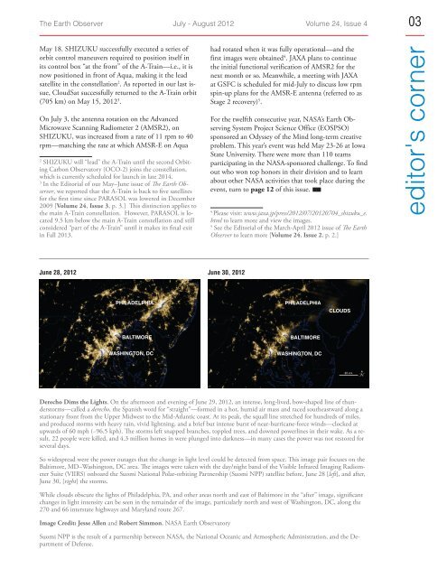
June 28, 2012 June 30, 2012<br />
philadelphia<br />
philadelphia<br />
clouds<br />
baltimore<br />
baltimore<br />
Washington, dc<br />
Washington, dc<br />
Derecho Dims the Lights. On the afternoon and evening of June 29, 2012, an intense, long-lived, bow-shaped line of thunderstorms—called<br />
a derecho, the Spanish word for “straight”—formed in a hot, humid air mass and raced southeastward along a<br />
stationary front from the Upper Midwest to the Mid-Atlantic coast. At its peak, the squall line stretched for hundreds of miles,<br />
and produced storms with heavy rain, vivid lightning, and a brief but intense burst of near-hurricane-force winds—clocked at<br />
upwards of 60 mph (~96.5 kph). The storms left snapped branches, toppled trees, and downed powerlines in their wake. As a result,<br />
22 people were killed, and 4.3 million homes in were plunged into darkness—in many cases the power was not restored for<br />
several days.<br />
So widespread were the power outages that the change in light level could be detected from space. This image pair focuses on the<br />
Baltimore, MD–Washington, DC area. The images were taken with the day/night band of the Visible Infrared Imaging Radiometer<br />
Suite (VIIRS) onboard the Suomi National Polar-orbiting Partnership (Suomi NPP) satellite before, June 28 [left], and after,<br />
June 30, [right] the storms.<br />
While clouds obscure the lights of Philadelphia, PA, and other areas north and east of Baltimore in the “after” image, significant<br />
changes in light intensity can be seen in the remainder of the image, particularly north and west of Washington, DC, along the<br />
270 and 66 interstate highways and Maryland route 267.<br />
Image Credit: Jesse Allen and Robert Simmon, NASA <strong>Earth</strong> Observatory<br />
Suomi NPP is the result of a partnership between NASA, the National Oceanic and Atmospheric Administration, and the Department<br />
of Defense.