SITE PLAN CHECKLIST X = Required M = May be required to ...
SITE PLAN CHECKLIST X = Required M = May be required to ...
SITE PLAN CHECKLIST X = Required M = May be required to ...

Create successful ePaper yourself
Turn your PDF publications into a flip-book with our unique Google optimized e-Paper software.
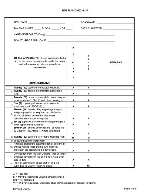
<strong>SITE</strong> <strong>PLAN</strong> <strong>CHECKLIST</strong><br />
APPLICANT: ___________________________<br />
TAX MAP SHEET: _____ BLOCK: ______ LOT _____<br />
ROAD NAME: ___________________________<br />
DATE SUBMITTED: ______________________<br />
NAME OF PROJECT (if any) ___________________________________________________<br />
SIGNATURE OF APPLICANT: __________________________________________________<br />
TO ALL APPLICANTS: If your application lacks<br />
any of the <strong>be</strong>low requirements, circle the items<br />
and in the remarks column, provide an<br />
explanation<br />
P<br />
r<br />
e<br />
l<br />
i<br />
m<br />
i<br />
n<br />
a<br />
r<br />
y<br />
F<br />
i<br />
n<br />
a<br />
l<br />
REMARKS<br />
ADMINISTRATIVE<br />
1 Twenty (20) copies of completed checklist. X X<br />
Twenty (20) copies of completed application<br />
2<br />
form. X X<br />
Twenty (20) paper prints of plats conforming <strong>to</strong><br />
3<br />
requirements of 132-110 and other drawings X X<br />
One (1) copy of plat in electronic format in<br />
4<br />
accordance with 132-110(H), X X<br />
Sixteen (16) copies of hydrogeological report<br />
and pump testing as <strong>required</strong> by 153-29 and<br />
5<br />
153-30 of Board of Health Code where<br />
construction of a well is <strong>required</strong> X X<br />
Six (6) copies of S<strong>to</strong>rmwater management plan<br />
6<br />
and supporting calculations X X<br />
Sixteen (16) copies of well testing, as <strong>required</strong><br />
7 by Chapter 153, Article II, where applicable<br />
X<br />
X<br />
8 Twenty (20) copies of Affordable Housing Plan M M<br />
9 Executed Escrow Agreement X X<br />
Financial disclosure statement for all persons or<br />
10 entities having more than a 10% financial<br />
interest in the property <strong>to</strong> <strong>be</strong> developed. X X<br />
Certification from the Tax Collec<strong>to</strong>r that all taxes<br />
11 and assessments on the entire tract have <strong>be</strong>en<br />
paid <strong>to</strong> date X X<br />
Proof of submission of application and fee<br />
12<br />
submitted <strong>to</strong> County Planning Board X NR<br />
X = <strong>Required</strong><br />
M = <strong>May</strong> <strong>be</strong> <strong>required</strong> <strong>to</strong> unusual circumstances<br />
NR = Not <strong>Required</strong><br />
W = Waiver requested. Applicant shall provide reason for request in writing.<br />
Revised 9/2009 Page 1 of 5
<strong>SITE</strong> <strong>PLAN</strong> <strong>CHECKLIST</strong><br />
TO ALL APPLICANTS: If your application lacks<br />
any of the <strong>be</strong>low requirements, circle the items<br />
and in the remarks column, provide an<br />
explanation<br />
P<br />
r<br />
e<br />
l<br />
i<br />
m<br />
i<br />
n<br />
a<br />
r<br />
y<br />
F<br />
i<br />
n<br />
a<br />
l<br />
REMARKS<br />
Proof of submission of application and fee <strong>to</strong><br />
New Jersey Department of Environmental<br />
13 Protection for Freshwater Wetlands Letter of<br />
Interpretation or Presence/Absence<br />
determination X X<br />
Proof of submission of application and fee<br />
14 submitted <strong>to</strong> County Soil Conservation District<br />
X<br />
X<br />
Certification as <strong>to</strong> D & R Canal Review Zone or<br />
15<br />
that property is exempt X X<br />
Copies of any existing or proposed convenants<br />
16 and deed restrictions intended <strong>to</strong> cover any of<br />
the development site X X<br />
Written requests for individual waivers and/or<br />
17<br />
variances X X<br />
<strong>PLAN</strong> REQUIREMENTS<br />
1 Site Plan size: 24 x 36 X X<br />
2 Scale: Not more than 1 inch =50 feet (written<br />
and graphic) and not less than 1 inch=20 feet<br />
(written and graphic) X X<br />
3 Key Map: site, streets, zones. Conforming <strong>to</strong><br />
requirements of 132-110 (north arrow <strong>to</strong> have<br />
same orientation as site plan) X X<br />
4 Prepared and sealed by licensed New Jersey<br />
professional engineer and/or land surveyor as<br />
appropriate X X<br />
5 CertifIcations per Map Filing Law X X<br />
6 Based on current survey prepared by licensed<br />
New Jersey land surveyor X X<br />
7 Bearings in degrees, minutes and seconds X X<br />
8 Title block giving names of site plan,<br />
applicant(s), owner(s) and preparer X X<br />
9 Current Tax Map sheet, block & lot num<strong>be</strong>r X X<br />
10 North arrow with reference meridian (same<br />
direction on all sheets) X X<br />
11 Date or original site plan and date & nature of<br />
each revision X X<br />
X = <strong>Required</strong><br />
M = <strong>May</strong> <strong>be</strong> <strong>required</strong> <strong>to</strong> unusual circumstances<br />
NR = Not <strong>Required</strong><br />
W = Waiver requested. Applicant shall provide reason for request in writing.<br />
Revised 9/2009 Page 2 of 5
<strong>SITE</strong> <strong>PLAN</strong> <strong>CHECKLIST</strong><br />
TO ALL APPLICANTS: If your application lacks<br />
any of the <strong>be</strong>low requirements, circle the items<br />
and in the remarks column, provide an<br />
explanation<br />
P<br />
r<br />
e<br />
l<br />
i<br />
m<br />
i<br />
n<br />
a<br />
r<br />
y<br />
F<br />
i<br />
n<br />
a<br />
l<br />
REMARKS<br />
12 Name(s) of the owners(s) of all propety within<br />
200 feet of the property <strong>be</strong>ing developed as<br />
disclosed by the most recent municipal tax<br />
records and certified by the municipal tax<br />
assessor X X<br />
13 All existing, proposed and <strong>required</strong> setback<br />
dimensions X X<br />
14 Location of existing and proposed property lines<br />
with dimensions <strong>to</strong> nearest 0.01 foot X NR<br />
15 Acreage of tract <strong>to</strong> nearest 0.01 acre X X<br />
16 Con<strong>to</strong>urs and <strong>to</strong>pography covering the property<br />
and surrounding area within 10 feet, maximum<br />
con<strong>to</strong>ur interval of 2 feet X X<br />
17 Existing & proposed drainage facilities on tract<br />
and within 200' (e.g., culverts, marshes, ponds,<br />
streams and floodplains) X X<br />
18 Location and type of existing and proposed<br />
easements or rights-of-way and utility<br />
structures, including ponds, drainage, sewer,<br />
water, sight rights, power, telephone & gas. X X<br />
19 Depiction of freshwater wetlands within 150 feet<br />
of the property. X X<br />
20 Documentation of feasibility of an adequate<br />
method of sewage disposal & reserve site X X<br />
21 Location and line of all existing streets & roads<br />
and areas dedicated <strong>to</strong> public use within 200'<br />
22 Location of existing and proposed buildings with<br />
dimensions showing X X<br />
23 Indicate the location of all existing and proposed<br />
structures, i.e., walls, fences, culverts, bridges,<br />
roadways, etc., with grade elevations<br />
X<br />
X<br />
24 Indicate existing zones of the development site<br />
and of any different zones within 200' X X<br />
25 The distance from the property line <strong>to</strong> the<br />
nearest intersection X X<br />
X = <strong>Required</strong><br />
M = <strong>May</strong> <strong>be</strong> <strong>required</strong> <strong>to</strong> unusual circumstances<br />
NR = Not <strong>Required</strong><br />
W = Waiver requested. Applicant shall provide reason for request in writing.<br />
Revised 9/2009 Page 3 of 5
<strong>SITE</strong> <strong>PLAN</strong> <strong>CHECKLIST</strong><br />
TO ALL APPLICANTS: If your application lacks<br />
any of the <strong>be</strong>low requirements, circle the items<br />
and in the remarks column, provide an<br />
explanation<br />
P<br />
r<br />
e<br />
l<br />
i<br />
m<br />
i<br />
n<br />
a<br />
r<br />
y<br />
F<br />
i<br />
n<br />
a<br />
l<br />
REMARKS<br />
26 Location, size and nature of the entire lot or lots<br />
in question or contigous lots owned by the<br />
applicant or owner of record or in which the<br />
applicant has a direct interest X X<br />
27 Identify all means of vehicular ingress and<br />
egress <strong>to</strong> and from the site on<strong>to</strong> public streets,<br />
showing the size and location of driveways, curb<br />
cuts and curbing, sight lines and radii X X<br />
28 Location and design of off-street parking areas<br />
X<br />
X<br />
29 Location, arrangement and dimensions of truck<br />
loading and unloading platforms and docks<br />
X<br />
X<br />
30 Indicate provisions for refuse and garbage<br />
disposal X X<br />
31 Show provisions for screening s<strong>to</strong>rage of<br />
equipment, attached or separate from buildings<br />
X<br />
X<br />
32 Indicate all existing or proposed exterior lighting,<br />
including foot-candle distribution X X<br />
33 Show all existing and proposed signs and their<br />
sizes X X<br />
34 Indication locations, dimensions and<br />
construction of off-site sidewalks, on-site walks<br />
and sidewalks X X<br />
35 Show proposed screening, green areas,<br />
landscaping and fencing, including a planting<br />
plan and schedule X X<br />
36 Show improvements <strong>to</strong> adjoining streets and<br />
roads and traffic control devices necessary in<br />
streets or highways X X<br />
37 Submit twenty (20) copies of elevations,<br />
sketches renderings or pictures of any new<br />
buildings, structures or alterations X X<br />
38 Show fire service lines, hydrants, siamese<br />
connections, au<strong>to</strong>matic sprinkler systems, fire<br />
zones, no-parking fire zones and pavement and<br />
wall signs X M<br />
X = <strong>Required</strong><br />
M = <strong>May</strong> <strong>be</strong> <strong>required</strong> <strong>to</strong> unusual circumstances<br />
NR = Not <strong>Required</strong><br />
W = Waiver requested. Applicant shall provide reason for request in writing.<br />
Revised 9/2009 Page 4 of 5
<strong>SITE</strong> <strong>PLAN</strong> <strong>CHECKLIST</strong><br />
TO ALL APPLICANTS: If your application lacks<br />
any of the <strong>be</strong>low requirements, circle the items<br />
and in the remarks column, provide an<br />
explanation<br />
P<br />
r<br />
e<br />
l<br />
i<br />
m<br />
i<br />
n<br />
a<br />
r<br />
y<br />
F<br />
i<br />
n<br />
a<br />
l<br />
REMARKS<br />
39 Complete construction plans (plans, profiles and<br />
cross sections at fifty-foot intervals and details)<br />
for all improvements, including roads, fences,<br />
drainage, water, sewer and surface water<br />
management facilities X X<br />
40 Lot grading plans, including proposed spot<br />
elevations, grade at building, floor elevations,<br />
proposed drainage patterns, etc. X X<br />
41 Location of natural features <strong>to</strong> <strong>be</strong> preserved,<br />
including conservation easements X X<br />
42 Soil erosion and sediment control plan in<br />
accordance with Chapter 103, Soil Erosion X X<br />
43 Calculations demonstrating the adequacy of<br />
existing and/or proposed drainage and/or<br />
surface water management facilties X X<br />
44 Mapping of Steep Slopes in accordance with<br />
114-3. X X<br />
45 Delineation of floodplain zones as <strong>required</strong> by<br />
132-115E X X NR<br />
46 Completed Constrained Area Maximum Tract<br />
Yield Calculation Form <strong>to</strong> <strong>be</strong> shown on Site Plan X X<br />
47 Depiction of Category One streams and<br />
tributaries within 300 feet of property X X<br />
48 Depiction of Septic systems and wells within<br />
100 feet of property X X<br />
49 Street address of each property shall <strong>be</strong><br />
indicated on all plats X X<br />
X = <strong>Required</strong><br />
M = <strong>May</strong> <strong>be</strong> <strong>required</strong> <strong>to</strong> unusual circumstances<br />
NR = Not <strong>Required</strong><br />
W = Waiver requested. Applicant shall provide reason for request in writing.<br />
Revised 9/2009 Page 5 of 5