A Technical Manual for Landowners, Loggers, and ... - Forestry
A Technical Manual for Landowners, Loggers, and ... - Forestry
A Technical Manual for Landowners, Loggers, and ... - Forestry

Create successful ePaper yourself
Turn your PDF publications into a flip-book with our unique Google optimized e-Paper software.
P R E- HA RV E S T<br />
P L A N N I NG<br />
■ Plan <strong>for</strong> the treatment of slash, site preparation, regeneration <strong>and</strong><br />
revegetation prior to harvesting.<br />
■ Carefully plan road layout along with l<strong>and</strong>ings, skid trails, stream<br />
crossings <strong>and</strong> drainage structures.<br />
N O T E S:<br />
A l ways dete rmine if a permit is re qu i red befo re beginning any fo re st manage m e n t<br />
activities. See Pe rmits <strong>and</strong> Regulations in the appendix of this publication <strong>for</strong> more<br />
i n fo rm a t i o n .<br />
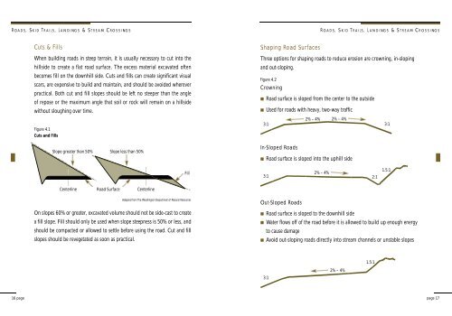
S T R E A M S I D E M A N A G E M E N T Z O N E<br />
The Streamside Management Zone (SMZ) is an area or strip of l<strong>and</strong> adjacent to<br />
a stream or other body of water where management practices are designed to<br />
p rotect water quality, aquatic wildlife <strong>and</strong> wildlife habitat. Trees <strong>and</strong> vegetation<br />
within the SMZ act as a natural filter to keep sediment out of streams, re d u c e<br />
soil erosion <strong>and</strong> act as a buffer to protect the stream from degradation caused<br />
by nearby activities. The SMZ is n o t a zone of exclusion where silvicultural<br />
activities are not permitted. Because of the need to protect water quality <strong>and</strong><br />
other important values, the SMZ is an area where silvicultural activities should<br />
be closely <strong>and</strong> carefully managed.<br />
Figure 3.1 Streamside Management Zone<br />
Adapted from The Bureau of <strong>Forestry</strong>, Wisconsin Department of Natural Resources<br />
100'<br />
C l a s s i fication cate g o ries used in dete rmining SMZ locations are :<br />
Class I St re a m<br />
S t reams or other bodies of water used <strong>for</strong> domestic water supply <strong>and</strong>/or<br />
the spawning, rearing, <strong>and</strong> migration of fish, including impacted stre a m s<br />
with recovery potential <strong>for</strong> a fishery. Also included are perennial streams that<br />
contribute significant flow to downstream fisheries. The width of the SMZ <strong>for</strong><br />
a Class I Stream is measured from the Ordinary High Water Mark on each<br />
side of the stream.<br />
8 page<br />
page 9