Integration of measurements and model simulations to ... - NILU
Integration of measurements and model simulations to ... - NILU
Integration of measurements and model simulations to ... - NILU

Create successful ePaper yourself
Turn your PDF publications into a flip-book with our unique Google optimized e-Paper software.
Atmos. Chem. Phys., 12, 10001–10013, 2012<br />
www.atmos-chem-phys.net/12/10001/2012/<br />
doi:10.5194/acp-12-10001-2012<br />
© Author(s) 2012. CC Attribution 3.0 License.<br />
Atmospheric<br />
Chemistry<br />
<strong>and</strong> Physics<br />
<strong>Integration</strong> <strong>of</strong> <strong>measurements</strong> <strong>and</strong> <strong>model</strong> <strong>simulations</strong> <strong>to</strong> characterize<br />
Eyjafjallajökull volcanic aerosols over south-eastern Italy<br />
M. R. Perrone 1 , F. De Tomasi 1 , A. S<strong>to</strong>hl 2 , <strong>and</strong> N. I. Kristiansen 2<br />
1 Physics Department, University <strong>of</strong> Salen<strong>to</strong>, Lecce, Italy<br />
2 <strong>NILU</strong>-Norwegian Institute for Air Research, Kjeller, Norway<br />
Correspondence <strong>to</strong>: M. R. Perrone (perrone@le.infn.it)<br />
Received: 21 May 2012 – Published in Atmos. Chem. Phys. Discuss.: 15 June 2012<br />
Revised: 26 September 2012 – Accepted: 1 Oc<strong>to</strong>ber 2012 – Published: 30 Oc<strong>to</strong>ber 2012<br />
Abstract. Volcanic aerosols resulting from the Eyjafjallajökull<br />
eruption were detected in south-eastern Italy from<br />
20 <strong>to</strong> 22 April 2010, at a distance <strong>of</strong> approximately 4000 km<br />
from the volcano, <strong>and</strong> have been characterized by lidar,<br />
sun/sky pho<strong>to</strong>meter, <strong>and</strong> surface in-situ <strong>measurements</strong>. Volcanic<br />
particles added <strong>to</strong> the pre-existing aerosol load <strong>and</strong><br />
measurement data allow quantifying the impact <strong>of</strong> volcanic<br />
particles on the aerosol vertical distribution, lidar<br />
ratios, the aerosol size distribution, <strong>and</strong> the ground-level<br />
particulate-matter concentrations. Lidar <strong>measurements</strong> reveal<br />
that backscatter coefficients by volcanic particles were<br />
about one order <strong>of</strong> magnitude smaller over south-eastern<br />
Italy than over Central Europe. Mean lidar ratios at 355 nm<br />
were equal <strong>to</strong> 64 ± 5 sr inside the volcanic aerosol layer <strong>and</strong><br />
were characterized by smaller values (47 ±2 sr) in the underlying<br />
layer on 20 April, 19:30 UTC. Lidar ratios <strong>and</strong> their<br />
dependence with the height reduced in the following days,<br />
mainly because <strong>of</strong> the variability <strong>of</strong> the volcanic particle contributions.<br />
Size distributions from sun/sky pho<strong>to</strong>meter <strong>measurements</strong><br />
reveal the presence <strong>of</strong> volcanic particles with radii<br />
r > 0.5 µm on 21 April <strong>and</strong> that the contribution <strong>of</strong> coarse<br />
volcanic particles increased from 20 <strong>to</strong> 22 April. The aerosol<br />
fine mode fraction from sun/sky pho<strong>to</strong>meter <strong>measurements</strong><br />
varied between values <strong>of</strong> 0.85 <strong>and</strong> 0.94 on 20 April <strong>and</strong> decreased<br />
<strong>to</strong> values between 0.25 <strong>and</strong> 0.82 on 22 April. Surface<br />
<strong>measurements</strong> <strong>of</strong> particle size distributions were in good<br />
accordance with column averaged particle size distributions<br />
from sun/sky pho<strong>to</strong>meter <strong>measurements</strong>. PM 1 /PM 2.5 mass<br />
concentration ratios <strong>of</strong> 0.69, 0.66, <strong>and</strong> 0.60 on 20, 21, <strong>and</strong> 22<br />
April, respectively, support the increase <strong>of</strong> super-micron particles<br />
at ground. Measurements from the Regional Air Quality<br />
Agency show that PM 10 mass concentrations on 20, 21,<br />
<strong>and</strong> 22 April 2010 were enhanced in the entire Apulia Region.<br />
More specifically, PM 10 mass concentrations have on<br />
average increased over Apulia Region 22 %, 50 %, <strong>and</strong> 28 %<br />
on 20, 21, <strong>and</strong> 22 April, respectively, compared <strong>to</strong> values on<br />
19 April. Finally, the comparison <strong>of</strong> measurement data with<br />
numerical <strong>simulations</strong> by the FLEXPART dispersion <strong>model</strong><br />
demonstrates the ability <strong>of</strong> FLEXPART <strong>to</strong> <strong>model</strong> the advection<br />
<strong>of</strong> the volcanic ash over the 4000 km from the Eyjafjallajökull<br />
volcano <strong>to</strong> Southern Italy.<br />
1 Introduction<br />
The eruption <strong>of</strong> the Eyjafjallajökull volcano in Icel<strong>and</strong> entered<br />
a phase <strong>of</strong> strong ash ejection <strong>to</strong> the atmosphere on 14<br />
April 2010, which lasted for several days. During the initial<br />
explosive phase, the eruption ejected volcanic ash <strong>to</strong> altitudes<br />
as high as 10 km above sea level (a.s.l.), as reported by the<br />
Institute <strong>of</strong> Earth Sciences (IES, http://www.earthice.hi.is).<br />
The westerly winds over Icel<strong>and</strong> transported the volcanic<br />
emissions first <strong>to</strong>ward northern Europe (starting with UK<br />
<strong>and</strong> Norway) (Petersen, 2010), <strong>and</strong> then <strong>to</strong>wards Central <strong>and</strong><br />
Southern Europe. Emeis et al. (2011) found from remote<br />
sensing data <strong>and</strong> numerical <strong>simulations</strong> that the first volcanic<br />
ash layer reached Germany on 16 April. The volcanic ash<br />
was detected in clear layers above Switzerl<strong>and</strong> starting from<br />
17 April (Bukowiecki et al., 2011), above southern Italy from<br />
19 April (Madonna et al., 2010; Mona et al., 2012), <strong>and</strong> over<br />
Greece after 21 April (Papayannis et al., 2012). The spatiotemporal<br />
distribution <strong>of</strong> the volcanic ash over Europe has<br />
been investigated extensively by EARLINET, the European<br />
Aerosol Research LIdar NETwork, which performed almost<br />
Published by Copernicus Publications on behalf <strong>of</strong> the European Geosciences Union.
10002 M. R. Perrone et al.: April 2010 Eyjafjallajökull volcanic aerosols over south-eastern Italy<br />
continuous <strong>measurements</strong> from 15 April <strong>to</strong> 22 May 2010<br />
(e.g. Ansmann et al., 2010; Wiegner et al., 2012; Gasteiger<br />
et al., 2011; Groß et al., 2011; Mona et al., 2012; Papayannis<br />
et al., 2012). Lidar instruments are well suited <strong>to</strong> observe<br />
aerosol layers at higher altitudes <strong>and</strong> can provide information<br />
about their vertical structure <strong>and</strong> development with time.<br />
In addition <strong>to</strong> lidars, different ground-based, airborne <strong>and</strong><br />
space-borne instruments have been used <strong>to</strong> characterize the<br />
physical <strong>and</strong> optical properties <strong>of</strong> the volcanic aerosols resulting<br />
from the Eyjfjallajökull eruption (e.g. Bukowiecki et<br />
al., 2011; Schäfer et al., 2011; Revuelta et al., 2012; Campanelli<br />
et al., 2012; Schumann et al., 2011, Toledano et al.,<br />
2012; Rossini et al., 2012).<br />
This paper focuses firstly on the integration <strong>of</strong> different<br />
<strong>measurements</strong> techniques <strong>to</strong> characterize aged volcanic<br />
aerosols at Lecce (40.4 ◦ N; 18.1 ◦ E), in south-eastern Italy,<br />
approximately 4000 km away from the Eyjafjallajökull volcano.<br />
After advection over so long distances, the volcanic<br />
ash is highly dispersed <strong>and</strong> the particle surfaces can be modified<br />
by condensation <strong>and</strong> coagulation processes upon contact<br />
with atmospheric trace gases <strong>and</strong> aerosols (Langmann<br />
et al., 2012). Therefore, the use <strong>of</strong> different remote sensing<br />
<strong>and</strong> in-situ sampling devices <strong>to</strong> characterize aged volcanic<br />
particles represents one <strong>of</strong> the main objectives <strong>of</strong> this study.<br />
Lidar <strong>measurements</strong> performed within EARLINET captured<br />
the spatiotemporal evolution <strong>of</strong> the volcanic aerosol plume<br />
over Lecce. Sun/sky pho<strong>to</strong>meter <strong>measurements</strong> performed<br />
within AERONET (Holben et al., 1998) at the lidar site<br />
allowed studying the volcanic aerosol effects on the main<br />
column-averaged aerosol optical <strong>and</strong> microphysical properties.<br />
Surface in-situ <strong>measurements</strong> showed how the volcanic<br />
ash influenced the particle size distribution <strong>and</strong> impacted the<br />
mass concentration <strong>of</strong> PM 1 <strong>and</strong> PM 2.5 particles. Finally, insitu<br />
SO 2 <strong>and</strong> PM 10 <strong>measurements</strong> performed by the Regional<br />
Air Quality Agency (www.arpa.puglia.it/web/guest/qariainq)<br />
have been analyzed <strong>to</strong> study the impact <strong>of</strong> volcanic aerosols<br />
on regional air quality in the entire Apulia Region. Synoptic<br />
meteorological maps <strong>and</strong> analytical back trajec<strong>to</strong>ries have<br />
mainly been used <strong>to</strong> infer the advection <strong>of</strong> volcanic aerosols<br />
<strong>to</strong> the moni<strong>to</strong>ring site. Aerosol observations performed thous<strong>and</strong>s<br />
<strong>of</strong> kilometres away from source regions are also important<br />
for the validation <strong>of</strong> volcanic ash transport <strong>model</strong>s.<br />
Therefore, measurement data have been compared with results<br />
from the dispersion <strong>model</strong> FLEXPART.<br />
An overview <strong>of</strong> the instrumentation <strong>and</strong> a brief description<br />
<strong>of</strong> the FLEXPART dispersion <strong>model</strong> are given in Sect. 2. Results<br />
<strong>and</strong> discussion are reported in Sect. 3. Main conclusions<br />
<strong>and</strong> caveats are presented in Sect. 4.<br />
2 Instrumentation <strong>and</strong> FLEXPART <strong>model</strong><br />
2.1 Experimental devices<br />
Remote sensing <strong>and</strong> surface in-situ <strong>measurements</strong> were conducted<br />
at the Physics Department <strong>of</strong> the University <strong>of</strong> Salen<strong>to</strong><br />
(40.4 ◦ N; 18.1 ◦ E), which is located 6 km away from the <strong>to</strong>wn<br />
<strong>of</strong> Lecce, in south-eastern Italy, <strong>and</strong> approximately 4000 km<br />
away from Icel<strong>and</strong>. Measurements are regularly performed<br />
there with a Raman lidar identified as UNILE (UNIversity <strong>of</strong><br />
LEcce) lidar. The lidar has been operative since the beginning<br />
<strong>of</strong> the European Aerosol Research LIdar NETwork (EAR-<br />
LINET) in May 2000 (Matthias et al., 2004) <strong>and</strong> nowadays<br />
employs an f/4 New<strong>to</strong>n telescope with a 30-cm-diameter mirror<br />
<strong>and</strong> a frequency-tripled Nd-YAG laser (355 nm) that delivers<br />
pulses <strong>of</strong> ∼ 350 mJ <strong>of</strong> energy at a repetition rate <strong>of</strong><br />
30 Hz. The UNILE lidar has been designed <strong>to</strong> derive vertical<br />
pr<strong>of</strong>iles <strong>of</strong> aerosol extinction (α(z)) <strong>and</strong> backscatter (β(z))<br />
coefficients <strong>and</strong> lidar ratios (LR(z)) during nighttime <strong>and</strong><br />
aerosol backscatter coefficients during daytime at a wavelength<br />
<strong>of</strong> 355 nm. Details on experimental apparatus <strong>and</strong> data<br />
analysis are reported in De Tomasi <strong>and</strong> Perrone (2003) <strong>and</strong><br />
De Tomasi et al. (2003, 2006). The statistical uncertainties <strong>of</strong><br />
β(z) are calculated from the error propagation law by assuming<br />
a Poisson noise on the lidar signals. The aerosol extinction<br />
coefficient is calculated by a linear fit <strong>of</strong> the derivative<br />
<strong>of</strong> the logarithm <strong>of</strong> the nitrogen Raman signal with respect<br />
<strong>to</strong> the range (Ansmann et al., 1992), <strong>and</strong> its uncertainties are<br />
set as the uncertainties associated <strong>to</strong> the slope <strong>of</strong> the fitting<br />
straight lines. Lidar ratio (LR(z) = α(z)/(β(z)) uncertainties<br />
are calculated using st<strong>and</strong>ard propagation techniques (Beving<strong>to</strong>n<br />
<strong>and</strong> Robinson, 2003). The lidar system is estimated<br />
<strong>to</strong> achieve full overlap between 0.3–0.5 km (Matthias et al.,<br />
2004).<br />
An AERONET sun/sky radiometer has been operative at<br />
the lidar site since March 2003. AERONET is a federated<br />
international network <strong>of</strong> sun/sky radiometers established in<br />
1993 (Holben et al., 1998). Data are publicly available online<br />
in near real-time mode (http://aeronet.gsfc.nasa.gov).<br />
The sun/sky radiometer measures direct sun radiance in<br />
eight spectral channels between 340 <strong>and</strong> 1020 nm (340, 380,<br />
440, 500, 670, 870, 940 <strong>and</strong> 1020 nm). Sky <strong>measurements</strong><br />
are performed at 440, 670, 870 <strong>and</strong> 1020 nm wavelengths<br />
through a wide range <strong>of</strong> scattering angles from the Sun (Holben<br />
et al., 1998). An au<strong>to</strong>mated cloud-screening algorithm<br />
(Smirnov et al., 2000) is applied <strong>to</strong> AOT direct-sun <strong>measurements</strong>.<br />
Aerosol microphysical parameters are retrieved<br />
from direct sun <strong>and</strong> diffuse sky radiance <strong>measurements</strong> by<br />
a flexible inversion algorithm, developed by Dubovik <strong>and</strong><br />
King (2000). A discussion on the accuracy <strong>of</strong> individual retrievals<br />
was reported in Dubovik et al. (2000). Quality assured<br />
(au<strong>to</strong>matically cloud cleared <strong>and</strong> manually inspected)<br />
level 2 AERONET data retrieved from <strong>measurements</strong> performed<br />
between 19 <strong>and</strong> 22 April 2010 were used in this<br />
study.<br />
Atmos. Chem. Phys., 12, 10001–10013, 2012<br />
www.atmos-chem-phys.net/12/10001/2012/
M. R. Perrone et al.: April 2010 Eyjafjallajökull volcanic aerosols over south-eastern Italy 10003<br />
For continuous aerosol size distribution <strong>measurements</strong> at<br />
about 10 m from the ground, a TSI Aerodynamic Particle<br />
Sizer (APS) 3321 with 51 channels <strong>of</strong> equal logarithmic<br />
width <strong>of</strong> 0.031 within the diameter size range <strong>of</strong> 0.54–<br />
20.0 µm was deployed. The APS <strong>measurements</strong> started on<br />
21 April at midday. Particulate matter (PM) samples have<br />
also been collected at ∼ 10 m above the ground level (a.g.l.)<br />
with a low volume (2.3 m 3 h −1 ) HYDRA-FAI dual sampler<br />
that allowed 24-h simultaneous collection <strong>of</strong> PM 2.5 <strong>and</strong> PM 1<br />
samples on 47-mm-diameter preheated filters (PALLFLEX,<br />
Tissuquartz). The filters were conditioned for 48 h (25 ◦ C <strong>and</strong><br />
50 % humidity) before <strong>and</strong> after sampling, <strong>and</strong> PM mass concentrations<br />
were determined by the gravimetric method. Uncertainties<br />
<strong>of</strong> the mass concentrations are below 5 %.<br />
2.2 The FLEXPART dispersion <strong>model</strong><br />
The Lagrangian particle dispersion <strong>model</strong> FLEXPART<br />
(S<strong>to</strong>hl et al., 1998, 2005) was used <strong>to</strong> simulate the transport<br />
<strong>of</strong> volcanic ash. FLEXPART was run in forward mode<br />
<strong>and</strong> driven with meteorological data from the European Centre<br />
for Medium-Range Weather Forecasts (ECMWF) analyses<br />
with 0.18 ◦ × 0.18 ◦ horizontal resolution <strong>and</strong> 91 vertical<br />
<strong>model</strong> levels. The simulation accounted for gravitational<br />
particle settling as well as dry <strong>and</strong> wet deposition, but not<br />
for ash aggregation processes. Formation <strong>of</strong> sulphate particles<br />
was also not simulated. Ash emission rates as a function<br />
<strong>of</strong> time <strong>and</strong> height, determined previously using an inversion<br />
scheme that coupled a priori source information <strong>and</strong> FLEX-<br />
PART <strong>model</strong> results with satellite data (S<strong>to</strong>hl et al., 2011),<br />
were used as a source term for this study. The ash particle<br />
size distribution included 25 particle size classes from 0.25–<br />
250 µm diameter. The <strong>model</strong> output had a horizontal resolution<br />
<strong>of</strong> 0.25 ◦ × 0.25 ◦ <strong>and</strong> a vertical resolution <strong>of</strong> 250 m.<br />
3 Results <strong>and</strong> discussion<br />
3.1 The advection <strong>of</strong> volcanic aerosols <strong>to</strong> south-eastern<br />
Italy<br />
The synoptic meteorological situation on 14–15 April, with<br />
a high located south <strong>of</strong> Icel<strong>and</strong> <strong>and</strong> a trough over northern<br />
Sc<strong>and</strong>inavia, favoured the transport <strong>of</strong> ash first over Norway<br />
<strong>and</strong> later over Southern Engl<strong>and</strong>, Denmark <strong>and</strong> Central<br />
Europe (e.g. Peterson, 2010; Folch et al., 2012). Stagnant<br />
conditions over Central Europe during the following days<br />
favoured a long residence time <strong>of</strong> the ash over Europe, associated<br />
with slow subsidence <strong>of</strong> the ash layers <strong>and</strong> settling<br />
<strong>of</strong> larger particles. The situation changed on 20 April when<br />
north-westerly winds transported parts <strong>of</strong> the volcanic ash<br />
plume first over south-eastern Europe <strong>and</strong> then over Eastern<br />
Europe on 23 April (Fig. 1 <strong>of</strong> the paper by Folch et al.,<br />
2012). Eight-day analytical back trajec<strong>to</strong>ries from the Hybrid<br />
Single Particle Lagrangian Integrated Trajec<strong>to</strong>ry Model<br />
(HYSPLIT) (Draxler <strong>and</strong> Rolph, 2010) have been analyzed<br />
in this study <strong>to</strong> infer the arrival <strong>of</strong> volcanic particles over<br />
Lecce. We found that air masses from south-eastern Europe<br />
<strong>and</strong> north-western Africa were mainly advected over<br />
south-eastern Italy up <strong>to</strong> ∼ 3 km a.s.l. on the diurnal hours<br />
<strong>of</strong> 19 April. Back trajec<strong>to</strong>ries with an origin over Central Europe<br />
arrived in south-eastern Italy up <strong>to</strong> ∼ 3 km a.s.l. on the<br />
morning <strong>of</strong> 20 April, in accordance with the synoptic meteorological<br />
situation (Folch et al., 2012). The arrival over<br />
the moni<strong>to</strong>ring site <strong>of</strong> this study <strong>of</strong> air masses which had<br />
previously travelled across Icel<strong>and</strong> started on the afternoon<br />
<strong>of</strong> 20 April. Figure 1a shows the 8-day back trajec<strong>to</strong>ries<br />
ending at the Physics Department <strong>of</strong> the Salen<strong>to</strong> University<br />
on 20 April at 18:00 UTC. The back trajec<strong>to</strong>ry ending<br />
at ∼ 0.5 km a.s.l. crossed Icel<strong>and</strong> before reaching the moni<strong>to</strong>ring<br />
site. The back trajec<strong>to</strong>ries ending at ∼ 2 <strong>and</strong> 3 km a.s.l.<br />
originated over Central Europe. However, they had then travelled<br />
over European regions known <strong>to</strong> have been affected by<br />
volcanic ash before reaching Lecce, <strong>and</strong> as a consequence<br />
may have been responsible for the advection <strong>of</strong> volcanic particles<br />
at altitudes larger than few kms a.s.l. Figure 1b shows<br />
the pathway <strong>of</strong> the back trajec<strong>to</strong>ries arriving over Lecce on<br />
21 April at 06:00 UTC. Both the 2 km- <strong>and</strong> the 3 km-arrivalheight<br />
back trajec<strong>to</strong>ries had travelled across Icel<strong>and</strong> before<br />
reaching Lecce. Figure 1c <strong>and</strong> d shows the pathways <strong>of</strong> back<br />
trajec<strong>to</strong>ries arriving over Lecce on 21 April at 18:00 UTC<br />
<strong>and</strong> on 22 April at 12:00 UTC. Air masses from northern<br />
Europe at lower altitudes <strong>and</strong> from north-western Africa at<br />
higher altitudes were transported <strong>to</strong> Lecce on 23 April. Thus,<br />
the transport <strong>of</strong> volcanic particles <strong>to</strong> south-eastern Italy was<br />
most likely on 20, 21, <strong>and</strong> 22 April according <strong>to</strong> HYSPLIT<br />
back trajec<strong>to</strong>ries. Analytical back trajec<strong>to</strong>ries provided by<br />
NASA (http://croc.gsfc.nasa.gov/aeronet/index.html) for the<br />
moni<strong>to</strong>ring site <strong>of</strong> this study, which are based on a kinetic<br />
trajec<strong>to</strong>ry analysis using NASA GMAO assimilated gridded<br />
data, were generally similar. It is also worth noting,<br />
that from 20 April, 21:00 UTC until 22 April, 03:09 UTC,<br />
volcanic particles were detected in the free troposphere at<br />
the CNR-IMAA Labora<strong>to</strong>ry in Potenza (40 ◦ 36 ′ N, 15 ◦ 44 ′ E,<br />
760 m a.s.l.), which is ∼ 250 km away from the moni<strong>to</strong>ring<br />
site <strong>of</strong> this study (Mona et al., 2012).<br />
Plots <strong>of</strong> volcanic-ash column-integrated mass concentrations<br />
over Europe from FLEXPART (Fig. 2) confirm the advection<br />
<strong>of</strong> volcanic aerosol over southeastern Italy from 20<br />
<strong>to</strong> 22 April. The green dot in Fig. 2 represents the lidar site.<br />
Simulated ash columnar mass concentrations at Lecce are<br />
higher than a few mg m −2 after the afternoon <strong>of</strong> 20 April.<br />
They reach the highest values <strong>of</strong> nearly 200 mg m −2 during<br />
the night <strong>of</strong> 20/21 April <strong>and</strong> subsequently decrease <strong>to</strong> rather<br />
low levels in the afternoon <strong>of</strong> 22 April. Notice that even the<br />
largest ash column loadings over Lecce are about one order<br />
<strong>of</strong> magnitude lower compared <strong>to</strong> those simulated by FLEX-<br />
PART over Central Europe on 16 April (S<strong>to</strong>hl et al., 2011).<br />
Thus, while some volcanic ash reached south-eastern Italy, it<br />
is much more diluted than earlier over Central Europe. Simulations<br />
<strong>of</strong> the Eyjafjallajökull volcanic ash dispersal over<br />
www.atmos-chem-phys.net/12/10001/2012/ Atmos. Chem. Phys., 12, 10001–10013, 2012
10004 M. R. Perrone et al.: April 2010 Eyjafjallajökull volcanic aerosols over south-eastern Italy<br />
April 20, 18:00 UTC<br />
(a) (b)<br />
April 21, 06 UTC<br />
6000<br />
4000<br />
2000<br />
0<br />
04/19 04/17 04/15 04/13<br />
8000<br />
4000<br />
0<br />
04/21 04/19 04/17 04/15<br />
April 21, 18:00 UTC<br />
(c) (d)<br />
April 22, 12:00 UTC<br />
6000<br />
4000<br />
2000<br />
0<br />
04/21 04/19 04/17 04/15<br />
6000<br />
4000<br />
2000<br />
0<br />
04/21 04/19 04/17 04/15<br />
Fig. 1. 8-day back trajec<strong>to</strong>ries from the Hybrid Single Particle Lagrangian Integrated Trajec<strong>to</strong>ry Model (HYSPLIT) <strong>of</strong> air masses ending at<br />
the Physics Department <strong>of</strong> the Salen<strong>to</strong> University, Lecce (Italy), (a) on 20 April at 18:00 UTC, (b) on 21 April at 06:00 UTC, (c) on 21 April<br />
at 18:00 UTC, <strong>and</strong> (d) on 22 April at 12:00 UTC.<br />
Figure 1 (M. R. Perrone et al.)<br />
Europe using COSMO-MUSCAT also revealed the advection<br />
<strong>of</strong> diluted ash over south-eastern Italy on 21 April (Fig. 4<br />
<strong>of</strong> the paper by Heinold et al., 2012).<br />
3.2 UNILE lidar <strong>measurements</strong><br />
Figure 3 (solid lines) shows the backscatter coefficient (β)<br />
pr<strong>of</strong>iles at 355 nm retrieved from lidar <strong>measurements</strong> performed<br />
from 20 April until 22 April. β-pr<strong>of</strong>iles have been<br />
retrieved from one-hour-average lidar <strong>measurements</strong>. More<br />
specifically, the pr<strong>of</strong>ile at 05:30 UTC was calculated by averaging<br />
lidar <strong>measurements</strong> from 05:00 <strong>to</strong> 06:00 UTC. Aerosol<br />
optical thicknesses (AOTs) at 355 nm, calculated from lidar<br />
pr<strong>of</strong>iles, are also reported in each plot <strong>of</strong> Fig. 3. To this<br />
end, we have assumed that extinction pr<strong>of</strong>iles did not vary<br />
with altitude in the lowermost aerosol layer, whose height<br />
is <strong>of</strong> the order <strong>of</strong> the planetary boundary layer (PBL) height<br />
(De Tomasi <strong>and</strong> Perrone, 2006). Then, we can assume that<br />
aerosol particles are well mixed within the PBL.<br />
Figure 3a shows that aerosol particles moni<strong>to</strong>red by the lidar<br />
were mainly located below 3 km from the ground level<br />
at 05:30 UTC on 20 April. The24<br />
aerosol-load-height increased<br />
with the time <strong>of</strong> day <strong>and</strong> the comparison <strong>of</strong> Fig. 3a <strong>and</strong> b<br />
shows that at 17:30 UTC, backscatter coefficients were characterized<br />
by larger values ( ∼ = 1.5 Mm −1 sr −1 ) mainly within<br />
the 2.5–3.0 km altitude range. We believe that the advection<br />
<strong>of</strong> volcanic aerosol has likely contributed <strong>to</strong> the increase <strong>of</strong><br />
β-values above 2.5 km a.s.l., in accordance with back trajec<strong>to</strong>ry<br />
pathways. The gradually descending layers <strong>of</strong> volcanic<br />
particles that were observed at the CNR-IMAA Labora<strong>to</strong>ry<br />
(Mona et al., 2012) from 20 April, 21:00 UTC, <strong>and</strong> 21<br />
April, 12:00 UTC, between about 4 km a.s.l. <strong>and</strong> the onset <strong>of</strong><br />
the PBL, support this. Notice that the β-values at 1064 nm<br />
retrieved at the CNR-IMAA Labora<strong>to</strong>ry varied within the<br />
0.05–2.0 Mm −1 sr −1 range within volcanic ash layers. Extinction<br />
(α) <strong>and</strong> lidar ratio (LR) pr<strong>of</strong>iles retrieved at Lecce<br />
from nighttime Raman lidar <strong>measurements</strong> (De Tomasi et<br />
Atmos. Chem. Phys., 12, 10001–10013, 2012<br />
www.atmos-chem-phys.net/12/10001/2012/
M. R. Perrone et al.: April 2010 Eyjafjallajökull volcanic aerosols over south-eastern Italy 10005<br />
(a)<br />
(b)<br />
(c)<br />
(d)<br />
(e)<br />
(f)<br />
Fig. 2. FLEXPART <strong>simulations</strong> <strong>of</strong> the Eyjafjallajökull volcanic ash (<strong>to</strong>tal atmospheric columns in mg m −2 , integrated over all 25 particle<br />
size classes) on 20 April at (a) 06:00 UTC, (b) 18:00 UTC, (c) 24:00 UTC, on 21 April at (d) 18:00 UTC, (e) 24:00 UTC, <strong>and</strong> on 22 April at<br />
(f) 18:00 UTC. The green dot marks the moni<strong>to</strong>ring site.<br />
al., 2006) are plotted in Fig. 4. The lidar ratio pr<strong>of</strong>ile at<br />
19:30 UTC on 20 April (Fig. 4a, dots) allows inferring two<br />
main aerosol layers: one extends up <strong>to</strong> about 1.8 km a.s.l.<br />
<strong>and</strong> is characterized by LRs = 47 ± 2 sr, <strong>and</strong> the other extends<br />
over the 2.1–3.3 km range <strong>and</strong> is characterized by lidar<br />
ratios spanning the 65–71 sr range (Table 1). The lower<br />
LR values retrieved up <strong>to</strong> 2 km a.s.l. (Fig. 4a, dots) are affected<br />
by the contribution <strong>of</strong> pre-existing aerosol particles,<br />
which are not <strong>of</strong> volcanic origin. We believe that the larger<br />
LRs retrieved within the upper aerosol layer are likely due<br />
<strong>to</strong> the contribution <strong>of</strong> volcanic aerosol: air masses from Central<br />
European regions known <strong>to</strong> have been affected by volcanic<br />
ash arrived at Lecce at altitudes larger than 2 km a.s.l.<br />
on the evening <strong>of</strong> 20 April. Notice that Ansmann et al. (2010)<br />
found that the volcanic ash plume moni<strong>to</strong>red on 16 April<br />
(14:15–15:30 UTC) at Leipzig (Germany) was characterized<br />
by lidar ratios at 355 nm <strong>of</strong> 55–65 sr (Table 1). Papayannis<br />
et al. (2012) found lidar ratios at 355 nm <strong>of</strong> 55–76 sr in volcanic<br />
aerosol layers 2.0–4.8 km a.s.l. moni<strong>to</strong>red over Greece<br />
<strong>and</strong> Turkey. Mean LR values at 355 nm retrieved at Lecce<br />
for different altitude ranges are compared in Table 1 with<br />
the corresponding ones retrieved at Potenza from 20 <strong>to</strong> 22<br />
www.atmos-chem-phys.net/12/10001/2012/ Atmos. Chem. Phys., 12, 10001–10013, 2012
10006 M. R. Perrone et al.: April 2010 Eyjafjallajökull volcanic aerosols over south-eastern Italy<br />
Altitude (km)<br />
6<br />
5<br />
4<br />
3<br />
2<br />
1<br />
0<br />
6<br />
5<br />
4<br />
3<br />
2<br />
1<br />
0<br />
0<br />
0<br />
2<br />
4<br />
20/04<br />
05:30 UTC<br />
AOT= 0.31<br />
Ash<br />
β<br />
6 0<br />
(a)<br />
21/04<br />
17:30 UTC<br />
AOT= 0.30<br />
(f)<br />
150<br />
0<br />
2<br />
4<br />
20/04<br />
17:30 UTC<br />
AOT= 0.41<br />
6 0<br />
(b)<br />
21/04<br />
23:30 UTC<br />
AOT= 0.25<br />
150<br />
β (Mm-sr) -1<br />
(g)<br />
0<br />
2<br />
4<br />
20/04<br />
23:30 UTC<br />
AOT= 0.32<br />
6 0<br />
(c)<br />
22/04<br />
02:30 UTC<br />
AOT= 0.32<br />
(h)<br />
150<br />
0<br />
2<br />
4<br />
21/04<br />
02:30 UTC<br />
AOT= 0.33<br />
6 0<br />
(d)<br />
22/04<br />
05:30 UTC<br />
AOT= 0.30<br />
Ash mass concentration (µg/m 3 )<br />
(i)<br />
150<br />
0<br />
2<br />
4<br />
21/04<br />
14:30 UTC<br />
AOT= 0.40<br />
6<br />
(e)<br />
22/04<br />
17:30 UTC<br />
AOT= 0.13<br />
Fig. 3. Vertical pr<strong>of</strong>iles <strong>of</strong> the aerosol backscatter coefficient at<br />
355 nm (solid line) <strong>and</strong> <strong>of</strong> the volcanic ash mass Figure concentration 3 (M. R. Perrone simulated<br />
by FLEXPART (dotted line) at different hours on 20, 21, <strong>and</strong><br />
et al.)<br />
22 April 2010.<br />
Altitude (km)<br />
4<br />
3<br />
2<br />
1<br />
0<br />
0<br />
0.0<br />
(a)<br />
20<br />
40<br />
0.2<br />
60<br />
Extinction<br />
LR<br />
80<br />
20/04<br />
19:30 UTC<br />
0<br />
0.4 0.0<br />
20<br />
(b)<br />
40<br />
0.2<br />
Lidar Ratio (sr)<br />
60<br />
80<br />
20/04<br />
23:30 UTC<br />
0<br />
0.4 0.0<br />
(c)<br />
20<br />
40<br />
0.2<br />
Extinction (km -1 )<br />
60<br />
80<br />
21/04<br />
02:30 UTC<br />
0<br />
0.4 0.0<br />
20<br />
(d)<br />
40<br />
0.2<br />
60<br />
(l)<br />
150<br />
80<br />
22/04<br />
02:30 UTC<br />
Fig. 4. Vertical pr<strong>of</strong>iles <strong>of</strong> the aerosol extinction coefficient (solid<br />
line) <strong>and</strong> <strong>of</strong> the lidar ratio (full dots) retrieved from nighttimes Figure 4 (M. lidar R. Perrone et al.)<br />
<strong>measurements</strong> at different hours on 20, 21, <strong>and</strong> 22 April 2010.<br />
April (Mona et al., 2012) <strong>and</strong> the one provided by Ansmann<br />
et al. (2010). It is worth noting that LR values retrieved at<br />
Lecce at 23:30 UTC on 20 April are in good accordance with<br />
the ones retrieved at Potenza within the same altitude range.<br />
The lidar <strong>measurements</strong> at 02:30 on 21 April (Fig. 4c, dots)<br />
shows that LR values were less dependent on altitude than<br />
for the earlier <strong>measurements</strong> (Table 1). The mixing <strong>of</strong> volcanic<br />
aerosols with underlying aerosol particles as a consequence<br />
<strong>of</strong> particle sedimentation, subsidence, <strong>and</strong>/or the spa-<br />
0.4<br />
Table 1. Mean values <strong>and</strong> st<strong>and</strong>ard deviations <strong>of</strong> the lidar ratios at<br />
355 nm retrieved at Lecce, Potenza, <strong>and</strong> Leipzig on different days<br />
<strong>and</strong> hours <strong>and</strong> at different altitude ranges.<br />
26<br />
Time Altitude LR 355nm<br />
(UTC) (km a.s.l.) (sr)<br />
16 April, 14:15–15:30 2.5.4.0 60 ± 5<br />
Ansmann et al. (2010)<br />
20 April, 19:00–20:00 0.6–1.8 47 ± 2<br />
2.1–3.3 64 ± 5<br />
20 April, 23:00–24:00 0.7–1.9 40 ± 3<br />
2.3–2.7 57 ± 3<br />
20 April, 21:00–23:05 2.0–3.0 42 ± 2<br />
Mona et al. (2012) 3.1–4.0 38 ± 6<br />
21 April, 02:00–03:00 0.6–2.1 45 ± 3<br />
2.4–3.1 53 ± 6<br />
22 April, 02:00–03:00 0.6–2.1 35 ± 3<br />
2.0–3.0 45 ± 5<br />
21–22 April, 19:07–03.09 1.6–3.4 80 ± 12<br />
Mona et al. (2012)<br />
tiotemporal variability <strong>of</strong> the volcanic aerosol contribution<br />
were likely responsible for this result.<br />
Aerosol particles up <strong>to</strong> about 4 km a.s.l. were detected by<br />
the lidar at 23:30 UTC on 20 April (Fig. 3c). The aerosol load<br />
<strong>and</strong> the maximum height where aerosols were detected by<br />
the lidar decreased with time on 21 April. These results are<br />
due <strong>to</strong> smaller contributions <strong>of</strong> both volcanic aerosols <strong>and</strong><br />
non-volcanic particles. Aerosol particles were located up <strong>to</strong><br />
∼ 3.2 km a.s.l. <strong>and</strong> lidar ratios spanned the 32–50 sr range at<br />
02:30 UTC on 22 April (Figs. 3g <strong>and</strong> 4d). Significantly larger<br />
LRs were retrieved on 21–22 April, 19:07–03:09 at Potenza.<br />
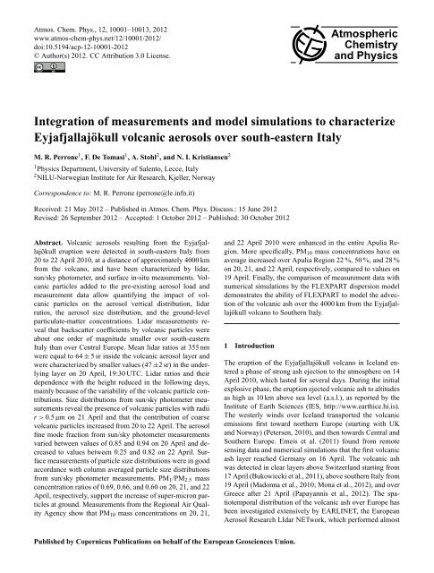
Figure 5 shows the time evolution from 20 <strong>to</strong> 22 April<br />
2010 <strong>of</strong> the aerosol optical thickness at 355 nm (open dots)<br />
retrieved from lidar <strong>measurements</strong>. Notice that non-volcanic<br />
aerosols likely contributed <strong>to</strong> the rather high AOTs retrieved<br />
from lidar <strong>measurements</strong> performed during the daytime<br />
hours <strong>of</strong> 20 April, if we assume that the advection <strong>of</strong><br />
volcanic particles over south-eastern Italy mainly occurred<br />
starting the evening <strong>of</strong> 20 April, in accordance with HYS-<br />
PLIT backtrajec<strong>to</strong>ries. AOT values vary significantly with<br />
time: they reach a peak value at ∼ 15:30 UTC on 21 April,<br />
then decrease, <strong>and</strong> then a peak value is again observed at<br />
about 03:00 UTC on 22 April. The advection over the moni<strong>to</strong>ring<br />
site <strong>of</strong> this study <strong>of</strong> an inhomogeneous cloud <strong>of</strong> volcanic<br />
particles was likely responsible for these results. In<br />
fact, Figs. 3 <strong>and</strong> 4 show that both the aerosol backscatter coefficient<br />
<strong>and</strong> lidar ratios varied with time <strong>and</strong> height from 20<br />
<strong>to</strong> 22 April.<br />
Atmos. Chem. Phys., 12, 10001–10013, 2012<br />
www.atmos-chem-phys.net/12/10001/2012/
M. R. Perrone et al.: April 2010 Eyjafjallajökull volcanic aerosols over south-eastern Italy 10007<br />
0.5<br />
0.4<br />
AOT (lidar, 355 nm)<br />
AOT (AERONET, 340 nm)<br />
Ma<br />
1.5<br />
0.4<br />
1.0<br />
0.8<br />
AOT<br />
0.3<br />
0.2<br />
0.1<br />
1.0<br />
0.5<br />
Ma ( 10 5 µg/m 2 )<br />
AOT (500 nm)<br />
0.3<br />
0.2<br />
0.6<br />
0.4<br />
0.2<br />
Fine fraction<br />
0.0<br />
00:00<br />
20/04<br />
12:00 00:00<br />
21/04<br />
12:00 00:00<br />
22/04<br />
Time (UTC)<br />
12:00 00:00<br />
23/04<br />
0.0<br />
Fig. 5. Time series <strong>of</strong> the aerosol optical thickness (AOT) at 355 nm<br />
Fig. 6. Time evolution from 20 <strong>to</strong> 22 April 2010 <strong>of</strong> Figure the aerosol 6 (M. R. optical<br />
thickness (AOT) at 500 nm (full dots) <strong>and</strong> <strong>of</strong> the fine mode<br />
Perrone)<br />
from lidar <strong>measurements</strong> (open dots) <strong>and</strong> <strong>of</strong> the Figure ash 5 <strong>to</strong>tal (M. R. column Perrone et al.)<br />
(Ma) simulated by FLEXPART at the lidar site (full triangles).<br />
fraction (open triangles) from AERONET sun/sky pho<strong>to</strong>meter <strong>measurements</strong>.<br />
Full dots represent the aerosol optical thickness at 340 nm from<br />
AERONET sun/sky pho<strong>to</strong>meter <strong>measurements</strong>.<br />
0.1<br />
00:00<br />
20/04<br />
12:00 00:00<br />
21/04<br />
12:00 00:00<br />
22/04<br />
Time (UTC)<br />
12:00 00:00<br />
23/04<br />
0.0<br />
3.3 AERONET sun/sky pho<strong>to</strong>meter <strong>measurements</strong><br />
AERONET aerosol products (Version 2, Level 2 data) are<br />
lacking for the moni<strong>to</strong>ring site <strong>of</strong> this study from 12 <strong>to</strong> 19<br />
April. In addition, only some aerosol products are available<br />
from 14:15 UTC on 20 April until 16:11 UTC on 21<br />
April. In particular, refractive index <strong>and</strong> single scattering<br />
albedo values have not been provided for these two days.<br />
The AERONET values <strong>of</strong> the AOT at 340 nm retrieved from<br />
sun/sky pho<strong>to</strong>meter <strong>measurements</strong> performed from 20 <strong>to</strong> 22<br />
April 2010 are plotted in Fig. 5 (full circles). We observe that<br />
the few available AERONET-AOTs at 340 nm are in satisfac<strong>to</strong>ry<br />
agreement with lidar AOTs at 355 nm. Figure 6 shows<br />
the evolution with time <strong>of</strong> the AOT at 500 nm (full dots)<br />
<strong>and</strong> the fine mode fraction η (open triangles) from 20 <strong>to</strong> 22<br />
April (Spectral Deconvolution Algorithm, Version 4.1, Level<br />
2 data). η represents the ratio <strong>of</strong> the AOT due <strong>to</strong> fine mode<br />
particles with a radius r smaller than 0.4–0.5 µm, <strong>to</strong> the <strong>to</strong>tal<br />
AOT. Figure 6 shows that AOT (500 nm) values on average<br />
decrease from 20 <strong>to</strong> 22 April, in accordance with lidar-AOTs<br />
(355 nm). 500 nm-AOTs also vary significantly with time <strong>and</strong><br />
reach a peak value at ∼ 15:30 UTC on 21 April, in accordance<br />
with lidar-AOTs (Fig. 5, open circles). The fine mode<br />
fraction decreases from 20 <strong>to</strong> 22 April (Fig. 6, open triangles),<br />
indicating that the contribution <strong>of</strong> coarse mode particles<br />
increases. The columnar volume size distribution pr<strong>of</strong>iles<br />
retrieved on 20 <strong>and</strong> 21 April from AERONET sun/sky<br />
pho<strong>to</strong>meter <strong>measurements</strong> are plotted in Fig. 7a <strong>and</strong> b. No<br />
data are available for 19 <strong>and</strong> 22 April. If we assume that<br />
the differences on the aerosol load moni<strong>to</strong>red on 20 <strong>and</strong> 21<br />
April are mainly due <strong>to</strong> the contribution <strong>of</strong> volcanic particles,<br />
we can use the differences between the volume size distribution<br />
retrieved on 21 April at 14:49 UTC ((dV (r)/dln r) A ), <strong>and</strong><br />
the one retrieved on 20 April at 14:15 UTC ((dV (r)/dln r) B ),<br />
<strong>to</strong> determine the size distribution <strong>of</strong> volcanic aerosols on 21<br />
April, 14:49 UTC. Figure 8 (solid line) shows the mass size<br />
distribution calculated in accordance with the following relationship:<br />
dM A−B /dLog(r) = ((dV (r)/dlnr) A − (dV (r)/dlnr) B ) · ln10 · ρ,<br />
where ρ = 3.0 g cm −3 represents the particle density for volcanic<br />
ash, according <strong>to</strong> Kristiansen et al. (2012). Positive<br />
dM A−B /dLog(r) values are found for the 0.05–0.11 µm radius<br />
range <strong>and</strong> for radii r > 0.5 µm (Fig. 8, solid line). While<br />
the difference for the small radii can be explained by the nucleation<br />
<strong>and</strong> subsequent growth <strong>of</strong> sulphate particles from<br />
volcanic SO 2 emissions, the difference for particles with radius<br />
r > 0.5 µm is very likely due <strong>to</strong> coarse volcanic particles.<br />
This result is consistent with <strong>measurements</strong> performed<br />
over Central Europe (e.g. Emeis et al., 2011; Petäjä et al.,<br />
2012). A drastic increase <strong>of</strong> particles with diameter greater<br />
28<br />
than 1 µm was observed at Augsburg, Germany, during the<br />
volcanic ash plume impact episode (Pitz et al., 2011). Moreover,<br />
size distribution <strong>measurements</strong> during aircraft flights<br />
over Central Europe also revealed the dominance <strong>of</strong> coarse<br />
particles <strong>to</strong> the <strong>to</strong>tal particulate mass in the volcanic ash<br />
plume (e.g. Schumann et al., 2011; Kristiansen et al., 2012).<br />
3.4 Surface in situ <strong>measurements</strong><br />
Figure 7c shows the volume size distributions from TSI-<br />
APS (3321) <strong>measurements</strong> performed at the lidar site<br />
(∼ 10 m a.s.l.) on 21 April at 14:49 <strong>and</strong> 16:11 UTC, respectively.<br />
Volume size distributions near the ground reach minimum<br />
values at a radius r ∼ = 0.46 µm <strong>and</strong> are characterized by<br />
a coarse mode peaking at r ∼ = 1.4 µm, in satisfac<strong>to</strong>ry agreement<br />
<strong>to</strong> the AERONET-volume size distributions retrieved<br />
at 14:49 <strong>and</strong> 16:11 UTC, respectively (Fig. 7b). The volume<br />
concentration <strong>of</strong> both the column-integrated <strong>and</strong> the groundbased<br />
distribution was larger at 16:11 than at 14:49 UTC.<br />
Hence, the significant contribution <strong>of</strong> particles with radius<br />
29<br />
www.atmos-chem-phys.net/12/10001/2012/ Atmos. Chem. Phys., 12, 10001–10013, 2012
10008 M. R. Perrone et al.: April 2010 Eyjafjallajökull volcanic aerosols over south-eastern Italy<br />
dV(r)/dln r (µm 3 /µm 2 )<br />
0.05<br />
0.04<br />
0.03<br />
0.02<br />
0.01<br />
20/04<br />
14:15 UTC<br />
15:43 UTC<br />
(a)<br />
dM/dLog(r) ( 10 5 µg/m 2 )<br />
1.0<br />
0.8<br />
0.6<br />
0.4<br />
0.2<br />
FLEXPART<br />
11:30 UTC<br />
14:30 UTC<br />
dM A-B /dLog(r)<br />
14:49 UTC<br />
0.00<br />
5 6 7 8 9<br />
0.1<br />
2 3 4 5 6 7 8 9<br />
1<br />
2 3 4 5 6 7 8 9<br />
10<br />
0.0<br />
5 6 7 8 9<br />
0.1<br />
2 3 4 5 6 7 8 9<br />
1<br />
2 3 4 5 6 7 8 9<br />
10<br />
dV(r)/dln r (µm 3 /µm 2 )<br />
0.05<br />
0.04<br />
0.03<br />
0.02<br />
0.01<br />
21/04<br />
06:46 UTC<br />
14:49 UTC<br />
16:11 UTC<br />
(b)<br />
Radius (µm)<br />
Figure 8 (M. R. Perrone et al.)<br />
Fig. 8. Columnar mass size distribution <strong>of</strong> volcanic particles inferred<br />
from the AERONET volume size distribution retrieved at<br />
14:49 UTC on 21 April, by setting the particle mass density for<br />
volcanic particles ρ = 3.0 g cm −3 (solid line). Columnar mass<br />
size distribution <strong>of</strong> volcanic ash from FLEXPART <strong>simulations</strong> at<br />
11:30 UTC (dotted line) <strong>and</strong> 14:30 UTC (dashed line) on 21 April<br />
2010.<br />
dV(r)/dln r (µm 3 /cm 3 )<br />
0.00<br />
14<br />
12<br />
10<br />
8<br />
6<br />
4<br />
2<br />
0<br />
5 6 7 8 9<br />
0.1<br />
2 3 4 5 6 7 8 9<br />
1<br />
2 3 4 5 6 7 8 9<br />
10<br />
Radius ( µm)<br />
5 6 7 8 9<br />
0.1<br />
2 3 4 5 6 7 8 9<br />
1<br />
2 3 4 5 6 7 8 9<br />
10<br />
Radius ( µm)<br />
21/04<br />
16:11 UTC<br />
14:49 UTC<br />
Fig. 7. Volume size distributions retrieved from AERONET sun/sky<br />
pho<strong>to</strong>meter <strong>measurements</strong> performed at different daytime hours <strong>of</strong><br />
(a) 20 <strong>and</strong> (b) 21 April 2010. (c) Volume size distributions retrieved<br />
at the ground level from Aerodynamic Particle Sizer (APS 3321,<br />
TSI) <strong>measurements</strong> performed on 21 April 2010 at different daytime<br />
hours.<br />
r > 1 µm revealed by Fig. 7c was likely due <strong>to</strong> the impact <strong>of</strong><br />
volcanic aerosol at ground. In situ <strong>measurements</strong> performed<br />
by Lettino et al. (2012) over southern Italy <strong>and</strong> by Rossini<br />
et al. (2012) over central Italy have also revealed the surface<br />
impact <strong>of</strong> volcanic particles with radius r > 1 µm.<br />
PM 1 (particles with an aerodynamic diameter ≤ 1 µm) <strong>and</strong><br />
PM 2.5 (particles with an aerodynamic diameter ≤ 2.5 µm)<br />
samples were also collected at the lidar site from 21 <strong>to</strong> 24<br />
April. Mass concentrations <strong>of</strong> daily PM 1 <strong>and</strong> PM 2.5 samples<br />
revealed that the PM 1 /PM 2.5 mass ratios were 0.69, 0.66, <strong>and</strong><br />
0.60 on 20, 21, <strong>and</strong> 22 April, respectively, indicating that the<br />
contribution <strong>of</strong> particles with radius > 1 µm increased from<br />
21 <strong>to</strong> 22 April, in accordance with the daily evolution <strong>of</strong> the<br />
AERONET fine mode fraction.<br />
(c)<br />
Surface in situ SO 2 <strong>and</strong> PM 10 <strong>measurements</strong> performed by<br />
the Regional Air Quality Agency (http://www.arpa.puglia.it/<br />
web/guest/qariainq) have been analyzed <strong>to</strong> infer the volcanic<br />
aerosol effects on regional scale. Enhanced PM 10 <strong>and</strong> SO 2<br />
concentrations were moni<strong>to</strong>red all over south-eastern Italy<br />
from 20 <strong>to</strong> 22 April 2010. Table 2 reports the daily PM 10<br />
mass concentrations moni<strong>to</strong>red from 19 <strong>to</strong> 23 April 2010, at<br />
10 sites <strong>of</strong> the 400 km long Apulia Region (Fig. 9), in addition<br />
<strong>to</strong> the average value (avg) over all sites. Uncertainties <strong>of</strong><br />
PM 10 values are smaller than 5 %. Yearly mean (Y-M) mass<br />
Figure 7 (M. R. concentrations Perrone et al.) ± 1 st<strong>and</strong>ard deviation (SD) <strong>and</strong> site type definition<br />
are also provided in the last two columns <strong>of</strong> Table 2.<br />
The largest PM 10 mass concentrations were moni<strong>to</strong>red on 21<br />
April at all sites (within experimental uncertainties), with the<br />
30<br />
exception <strong>of</strong> site A, the site furthest in the north, where the<br />
largest PM 10 level was reached on 20 April. These results<br />
suggest that the PM 10 enhancement was very likely due <strong>to</strong><br />
a large-scale pollution event, consistent with the arrival <strong>of</strong><br />
volcanic particles (Sect. 3.1). PM 10 levels larger than corresponding<br />
yearly-means were reached at most <strong>of</strong> the sites<br />
on 20 or 21 April. The inhomogeneous structure <strong>of</strong> the volcanic<br />
particle cloud was likely responsible for the variability<br />
<strong>of</strong> the PM 10 enhancement found at different sites. Enhanced<br />
PM 10 mass concentrations were found all over Europe when<br />
the volcanic ash cloud was present (e.g. Schäfer et al., 2011;<br />
Emeis et al., 2011). PM 10 averaged values reported in Table<br />
2 show that the mean PM 10 mass concentrations in the<br />
Apulia region increased by 4, 9, <strong>and</strong> 5 µg m −3 (or by 22, 50,<br />
31<br />
Atmos. Chem. Phys., 12, 10001–10013, 2012<br />
www.atmos-chem-phys.net/12/10001/2012/
M. R. Perrone et al.: April 2010 Eyjafjallajökull volcanic aerosols over south-eastern Italy 10009<br />
Table 2. PM 10 mass concentrations (µg m −3 ) measured at different sites in the Apulia Region (shown in Fig. 9) from 19 <strong>to</strong> 23 April 2010.<br />
Yearly-mean (Y-M) mass concentrations ± 1 st<strong>and</strong>ard deviation (SD) <strong>and</strong> site type definition are provided in the last two columns.<br />
Site 19 April 20 April 21 April 22 April 23 April Y-M ± SD Site<br />
(µg m −3 ) (µg m −3 ) (µg m −3 ) (µg m −3 ) (µg m −3 ) (µg m −3 ) Type<br />
A 26 33 28 22 20 19 ± 11 rural<br />
B 15 20 27 21 21 23 ± 9 suburban<br />
C 23 23 44 26 36 29 ± 18 suburban<br />
D 20 24 27 24 21 25 ± 16 suburban<br />
E 18 21 24 24 20 16 ± 14 suburban<br />
F 13 21 25 25 19 21 ± 10 suburban<br />
G 12 17 25 20 20 20 ± 12 rural<br />
H 18 19 24 25 22 25 ± 13 suburban<br />
I 18 22 24 23 19 26 ± 13 suburban<br />
L 15 18 20 20 19 23 ± 15 suburban<br />
Avg 18 22 27 23 22<br />
6.0<br />
5.5<br />
(a)<br />
Site C<br />
SO 2<br />
PM10<br />
120<br />
100<br />
SO 2 Mass Concentration (µg/m 3 )<br />
5.0<br />
4.5<br />
4.0<br />
3.5<br />
3.0<br />
10<br />
8<br />
6<br />
4<br />
2<br />
(b)<br />
Site G<br />
80<br />
60<br />
40<br />
20<br />
0<br />
50<br />
40<br />
30<br />
20<br />
10<br />
PM10 Mass Concentration (µg/m 3 )<br />
0<br />
00:00<br />
04/19<br />
32<br />
12:00 00:00<br />
04/20<br />
12:00 00:00<br />
04/21<br />
12:00 00:00<br />
04/22<br />
Time (UTC)<br />
12:00 00:00 12:00 00:00<br />
04/23 04/24<br />
Fig. 10. Time series <strong>of</strong> PM 10 <strong>and</strong> SO 2 mass concentrations at sites<br />
C <strong>and</strong> G (locations are shown in Fig. 9). Figure 10 (M. R. Perrone et al.)<br />
Fig. 9. Geographical locations <strong>of</strong> selected sites <strong>of</strong> the Air Quality<br />
Agency <strong>of</strong> the Apulia Region in south-eastern Italy <strong>and</strong> <strong>of</strong> the lidar<br />
site.<br />
Figure 9 (M. R. Perrone et al.)<br />
also emitted by the volcano. Correlations between particulate<br />
matter <strong>and</strong> SO 2 in the Eyjafjallajökull plume have been<br />
observed earlier both by aircraft (Schumann et al., 2011) as<br />
<strong>and</strong> 28 %) on 20, 21, <strong>and</strong> 22 April, respectively, relative <strong>to</strong> well as from the ground (e.g. Emeis et al., 2011). Figure 10b<br />
the mean PM 10 level on 19 April. The PM 10 enhancements reveals that a fast increase <strong>of</strong> PM 10 <strong>and</strong> SO 2 mass concentrations<br />
occurred at ∼ 06:00 UTC on 20 April <strong>and</strong> that high<br />
at site I (∼ 500 m away from the lidar site) were 4, 6, <strong>and</strong><br />
5 µg m −3 on 20, 21, <strong>and</strong> 22 April, respectively.<br />
peak SO 2 mass concentrations were reached earlier at site G<br />
Figure 10 shows the time series <strong>of</strong> PM 10 <strong>and</strong> SO 2 mass than at site C, even though site G is further south than site C.<br />
concentrations at sites G <strong>and</strong> C (Fig. 9), which are approximately<br />
one hundred <strong>and</strong> two hundred kms away from cloud <strong>of</strong> volcanic particles was likely responsible for these<br />
The advection over south-eastern Italy <strong>of</strong> an inhomogeneous<br />
the lidar site. The correlation between PM 10 <strong>and</strong> SO 2 mass results. Volcanic particles were detected at the CNR-IMAA<br />
33<br />
concentrations, especially at site C, is also suggestive <strong>of</strong> a Labora<strong>to</strong>ry which is ∼ 150 km away from site G, since the<br />
volcanic source <strong>of</strong> the PM 10 enhancements, since SO 2 is night <strong>of</strong> 19 April (Madonna et al., 2010; Mona et al., 2012)<br />
www.atmos-chem-phys.net/12/10001/2012/ Atmos. Chem. Phys., 12, 10001–10013, 2012<br />
0
10010 M. R. Perrone et al.: April 2010 Eyjafjallajökull volcanic aerosols over south-eastern Italy<br />
<strong>and</strong> back trajec<strong>to</strong>ry pathways reveal that the back trajec<strong>to</strong>ry<br />
ending on 20 April, 06:00 UTC at 100 m a.s.l. crossed the<br />
CNR IMAA Labora<strong>to</strong>ry area before reaching site G.<br />
3.5 Measurements <strong>and</strong> FLEXPART <strong>simulations</strong><br />
Experimental results are compared in this section with numerical<br />
results from the dispersion <strong>model</strong> FLEXPART <strong>to</strong><br />
contribute <strong>to</strong> the validation <strong>of</strong> the <strong>model</strong> abilities at a distance<br />
<strong>of</strong> approximately 4000 km from the volcano site. Dotted lines<br />
in Fig. 3 represent one-hour average vertical pr<strong>of</strong>iles <strong>of</strong> the<br />
volcanic ash mass concentration at the lidar site from FLEX-<br />
PART <strong>simulations</strong>. The comparison <strong>of</strong> solid <strong>and</strong> dotted lines<br />
in Fig. 3 reveals the ability <strong>of</strong> the <strong>model</strong> <strong>to</strong> catch, at least in<br />
some cases, main features <strong>of</strong> the aerosol vertical distribution<br />
retrieved from lidar <strong>measurements</strong>. One must be aware that<br />
volcanic ash mass concentration pr<strong>of</strong>iles from FLEXPART<br />
cannot be directly compared <strong>to</strong> lidar pr<strong>of</strong>iles, since FLEX-<br />
PART pr<strong>of</strong>iles are only representative <strong>of</strong> volcanic ash particles,<br />
while non-volcanic particles have also contributed <strong>to</strong> the<br />
retrieved lidar pr<strong>of</strong>iles.<br />
Notice that FLEXPART predicts the arrival <strong>of</strong> ash on 20<br />
April, 17:30 UTC (Fig. 3b, dotted line) within the altitude<br />
range for which backscatter coefficient values (Fig. 3b, solid<br />
line) were ascribed <strong>to</strong> a larger contribution <strong>of</strong> volcanic particles,<br />
in accordance with the discussion reported in Sect. 3.2.<br />
Aerosol particles up <strong>to</strong> about 4 km have been detected by<br />
the lidar at 23:30 UTC on 20 April <strong>and</strong> the vertical structure<br />
<strong>of</strong> β (Fig. 3c, solid line) <strong>and</strong> LR (Fig. 4b, full dots) have<br />
allowed inferring the presence <strong>of</strong> two aerosol layers, with<br />
the upper layer (2.1–3.3 km a.s.l.) characterized by larger LR<br />
values (64 ± 5 sr) due <strong>to</strong> a larger contribution <strong>of</strong> volcanic particles<br />
(Ansmann et al., 2010). Accordingly, the FLEXPART<br />
pr<strong>of</strong>ile at 23:30 UTC (Fig. 3c, dotted line) shows that a volcanic<br />
ash layer extends from ∼ 2 km up <strong>to</strong> 3.7 km a.s.l. The<br />
highest concentrations <strong>of</strong> about 170 µg m −3 at ∼ 3 km a.s.l.<br />
are about a fac<strong>to</strong>r <strong>of</strong> 7 lower than the highest values on 16<br />
April over Leipzig. This suggests that the volcanic ash over<br />
south-eastern Italy was strongly diluted. Notice that on 16<br />
April, Asmann et al. (2010) found from lidar <strong>measurements</strong><br />
at 355 nm performed over Leipzig, that backscatter <strong>and</strong> extinction<br />
coefficients reached peak values <strong>of</strong> 7.5 Mm −1 sr −1<br />
<strong>and</strong> 370 Mm −1 , respectively in the center <strong>of</strong> the ash plume.<br />
Figure 3c (solid line) <strong>and</strong> Fig. 4b (solid line) show that at<br />
23:30 UTC on 20 April backscatter <strong>and</strong> extinction coefficients<br />
reached values up <strong>to</strong> 0.7 Mm −1 sr −1 <strong>and</strong> 30 Mm −1 ,<br />
respectively, within 3–4 km a.s.l. We have assumed that the<br />
aerosol load located above 3 km from the ground was mainly<br />
due <strong>to</strong> volcanic aerosol. Hence, extinction <strong>and</strong> backscatter<br />
coefficients over Lecce in the volcanic aerosol layer were<br />
about a fac<strong>to</strong>r <strong>of</strong> 10 lower than the highest values moni<strong>to</strong>red<br />
at Leipzig on 16 April. This is in reasonable accordance<br />
with FLEXPART ratios <strong>of</strong> peak ash mass concentrations at<br />
Leipzig (16 April) <strong>and</strong> Lecce (20 April).<br />
Figure 3g (dotted line) shows that the simulated volcanic<br />
ash was mainly located from the ground up <strong>to</strong> ∼ 1.2 km<br />
<strong>and</strong> from 2 up <strong>to</strong> ∼ 3.7 km at 23:30 UTC on 21 April, in<br />
satisfac<strong>to</strong>ry accordance with lidar <strong>measurements</strong> which detected<br />
aerosol particles up <strong>to</strong> ∼ 3.7 km a.s.l. (Fig. 3g, solid<br />
line). Both the backscatter coefficient values (solid line) <strong>and</strong><br />
the simulated volcanic ash mass concentrations (dotted line)<br />
were characterized by rather low values at 17:30 UTC on 22<br />
April (Fig. 3l), suggesting an end <strong>of</strong> the volcanic ash episode.<br />
Figure 5 shows the time evolution from 20 <strong>to</strong> 22 April<br />
2010 <strong>of</strong> the ash <strong>to</strong>tal column mass concentration from FLEX-<br />
PART (Ma, full triangles) above the lidar site, in addition <strong>to</strong><br />
the aerosol optical thickness at 355 nm (open dots) retrieved<br />
from lidar <strong>measurements</strong>. Ash <strong>to</strong>tal column mass concentration<br />
values vary significantly with time <strong>and</strong> reach rather<br />
low values after midday on 22 April. Accordingly, we have<br />
found that AOT values also were quite dependent on moni<strong>to</strong>ring<br />
time <strong>and</strong> reached rather low values after midday on<br />
22 April. Ma <strong>and</strong> AOT reach high peak values at different<br />
times. Uncertainties in the <strong>model</strong> <strong>simulations</strong> which grow as<br />
the ash cloud is transported far from its source <strong>and</strong> over complex<br />
<strong>to</strong>pography (e.g., the Alps) (Kristiansen et al., 2012) are<br />
expected <strong>to</strong> lead <strong>to</strong> some discrepancies between the <strong>model</strong><br />
<strong>and</strong> <strong>measurements</strong> for the diluted ash cloud over Southern<br />
Italy. Kristiansen et al. (2012) found a time delay between the<br />
<strong>model</strong>led <strong>and</strong> measured PM 10 peak values at the Jungfraujoch<br />
station (Swiss Alps). However, one must be aware that<br />
changes <strong>of</strong> the contribution by volcanic <strong>and</strong> non-volcanic<br />
particles have contributed <strong>to</strong> the variability with time <strong>of</strong> the<br />
AOT, while Ma was only due <strong>to</strong> volcanic ash.<br />
The FLEXPART mass size distributions (dM/dLog(r)) for<br />
the moni<strong>to</strong>ring site <strong>of</strong> this study are plotted in Fig. 11a–<br />
c at different daytime hours <strong>of</strong> 20, 21, <strong>and</strong> 22 April. Mass<br />
size distribution pr<strong>of</strong>iles <strong>of</strong> Fig. 11 represent 1-hour-average<br />
pr<strong>of</strong>iles. Please note that the dM/dlog(r) data points <strong>of</strong> the<br />
20 April pr<strong>of</strong>ile at 23:30 UTC (Fig. 11a) must be multiplied<br />
by a fac<strong>to</strong>r <strong>of</strong> 2: volcanic ash mass concentrations reached<br />
the highest values on the night <strong>of</strong> 20 April over southeastern<br />
Italy. Figure 11 shows that <strong>model</strong>led mass size distributions<br />
are dominated by particles with radius r > 1 µm.<br />
Dotted <strong>and</strong> dashed lines in Fig. 8 show for comparison the<br />
FLEXPART mass size distributions referring <strong>to</strong> 11:30 <strong>and</strong><br />
14:30 UTC, respectively, on 21 April. Hence, experimentally<br />
determined dM A−B /dlog(r) values are in reasonable agreement<br />
with FLEXPART mass size distributions, within the<br />
<strong>model</strong> expected uncertainties: both the experimentally determined<br />
<strong>and</strong> the FLEXPART size distributions reveal the significant<br />
contribution <strong>of</strong> particles within the 0.6–4 µm radius<br />
range, even though peak values are reached at different radii.<br />
Again, one must be aware that FLEXPART particle size distributions<br />
cannot be directly compared <strong>to</strong> AERONET columnar<br />
volume size distributions, since non-volcanic particles as<br />
well as sulphate particles <strong>of</strong> volcanic origin may have contributed<br />
<strong>to</strong> the retrieved AERONET pr<strong>of</strong>iles. It is worth noting<br />
from Fig. 11 that the <strong>model</strong>ed mass size distributions for<br />
Atmos. Chem. Phys., 12, 10001–10013, 2012<br />
www.atmos-chem-phys.net/12/10001/2012/
M. R. Perrone et al.: April 2010 Eyjafjallajökull volcanic aerosols over south-eastern Italy 10011<br />
2.5<br />
2.0<br />
1.5<br />
1.0<br />
20/04<br />
17:30 UTC<br />
20:30 UTC<br />
23:30 UTC (x 0.5)<br />
(a)<br />
sonable accordance with the <strong>measurements</strong> at site I, which is<br />
only a few hundred meters away from the lidar site. There,<br />
the PM 10 enhancements were 4, 6, <strong>and</strong> 5 µg m −3 on 20, 21,<br />
<strong>and</strong> 22 April, respectively (Table 2).<br />
dM/dLog(r) (10 5 µg/m 2 )<br />
0.5<br />
0.0<br />
2.5<br />
2.0<br />
1.5<br />
1.0<br />
0.5<br />
0.0<br />
2.5<br />
2.0<br />
1.5<br />
1.0<br />
0.5<br />
0.0<br />
5 6 7 8 9<br />
0.1<br />
2 3 4 5 6 7 8 9<br />
1<br />
2 3 4 5 6 7 8 9<br />
10<br />
21/04<br />
02:30 UTC<br />
14:30 UTC<br />
23:30 UTC<br />
5 6 7 8 9<br />
0.1<br />
2 3 4 5 6 7 8 9<br />
1<br />
2 3 4 5 6 7 8 9<br />
10<br />
22/04<br />
02:30 UTC<br />
05:30 UTC<br />
17:30 UTC<br />
5 6 7 8 9<br />
0.1<br />
2 3 4 5 6 7 8 9<br />
1<br />
2 3 4 5 6 7 8 9<br />
10<br />
Radius (µm)<br />
(b)<br />
(c)<br />
Figura 11 (M. R. Perrone et al.)<br />
Fig. 11. Columnar mass size distribution <strong>of</strong> volcanic ash from<br />
FLEXPART <strong>simulations</strong> at different hours on (a) 20, (b) 21, <strong>and</strong><br />
(c) 22 April 2010.<br />
Figure 12 (M. R. Perrone et al.)<br />
Fig. 12. Time evolution at the lidar site <strong>of</strong> the volcanic ash mass<br />
concentration (µg m −3 ) at ∼ 150 m a.s.l. from FLEXPART <strong>simulations</strong>.<br />
Daily means on 20, 21, <strong>and</strong> 22 April are also provided.<br />
22 April (Fig. 11c) are shifted <strong>to</strong> larger particle sizes than<br />
the ones for 20 April (Fig. 11a). This result is in accordance<br />
with both the AERONET fine-mode-fraction means that decreased<br />
from 20 <strong>to</strong> 22 April (Fig. 6, open triangles) <strong>and</strong> the<br />
ground <strong>measurements</strong> <strong>of</strong> size segregated mass concentrations<br />
(Fig. 7c).<br />
Figure 12 shows the time evolution <strong>of</strong> the volcanic ash<br />
mass concentrations (µg m −3 ) from FLEXPART <strong>simulations</strong><br />
at the lidar site <strong>and</strong> at ∼ 150 m a.s.l. Daily means <strong>of</strong> the volcanic<br />
ash mass concentration are 0.7, 4.5, <strong>and</strong> 3.8 µg m −3 on<br />
20, 21, <strong>and</strong> 22 April, respectively. These results are in rea-<br />
4 Summary <strong>and</strong> conclusion<br />
Results on the characterization <strong>of</strong> aged volcanic aerosol by lidar,<br />
sun/sky pho<strong>to</strong>meter, <strong>and</strong> surface in-situ <strong>measurements</strong> at<br />
a south-eastern Italian site, which is approximately 4000 km<br />
away from the Eyjfjallajökull volcano, have been reported.<br />
Meteorological synoptic maps <strong>and</strong> analytical back trajec<strong>to</strong>ries<br />
have revealed that southern Italy was mainly affected<br />
by volcanic ash particles from 20 <strong>to</strong> 22 April 2010, in accordance<br />
with other published studies. However, the volcanic<br />
ash over southeastern Italy was strongly diluted. The<br />
extinction <strong>and</strong> backscatter coefficients retrieved in volcanic<br />
aerosol layers at Lecce were about a fac<strong>to</strong>r <strong>of</strong> 10 lower than<br />
the highest values moni<strong>to</strong>red at Leipzig on 16 April. Lidar<br />
<strong>measurements</strong> performed at the Physics Department <strong>of</strong><br />
the University <strong>of</strong> Salen<strong>to</strong> within EARLINET showed that<br />
at 19:30 UTC on 20 April, volcanic particles were located<br />
near 2.1–3.3 km a.g.l. Mean lidar ratios (LRs) at 355 nm were<br />
64 ± 5 sr inside the volcanic aerosol layer, but only about<br />
47 ± 2 sr at lower altitudes. The dependence <strong>of</strong> LR values<br />
on altitude decreased with time mainly because <strong>of</strong> the high<br />
variability <strong>of</strong> the volcanic particle contributions. In fact, the<br />
vertical structure <strong>of</strong> the lidar backscatter coefficient <strong>and</strong> <strong>of</strong><br />
the AOT at 355 nm varied significantly on 20, 21, <strong>and</strong> 22<br />
April.<br />
AERONET sun/sky pho<strong>to</strong>meter <strong>measurements</strong> revealed<br />
that volcanic particles with radius r > 0.5 µm arrived over<br />
south-eastern Italy <strong>and</strong> that the contribution <strong>of</strong> coarse particles<br />
increased with time: the aerosol fine mode fraction varied<br />
from 0.85 <strong>to</strong> 0.94 on 20 April <strong>and</strong> from 0.25 <strong>to</strong> 0.82 on 22<br />
34<br />
April. Ground-level in-situ <strong>measurements</strong> <strong>of</strong> the aerosol size<br />
distribution were in satisfac<strong>to</strong>ry accordance with columnaraverage<br />
size distributions from sun/sky pho<strong>to</strong>meter <strong>measurements</strong>.<br />
Daily PM 1 <strong>and</strong> PM 2.5 mass concentrations showed<br />
that the PM 1 /PM 2.5 ratio was 0.69, 0.66, <strong>and</strong> 0.60 on 20,<br />
21, <strong>and</strong> 22 April, again suggesting the advection <strong>of</strong> volcanic<br />
particles with aerodynamic radius r > 0.5 µm, in accordance<br />
with AERONET sun/sky pho<strong>to</strong>meter <strong>measurements</strong>.<br />
Enhanced PM 10 <strong>and</strong> SO 2 concentrations were also found all<br />
over a 400 km long area <strong>of</strong> southern Italy from 20 <strong>to</strong> 22 April<br />
2010. In particular, PM 10 mass concentrations averaged over<br />
all <strong>measurements</strong> in the Apulia Region increased by 22 %,<br />
50 %, <strong>and</strong> 28 % on 20, 21, <strong>and</strong> 22 April, respectively, compared<br />
<strong>to</strong> values on 19 April.<br />
The comparison <strong>of</strong> experimental <strong>measurements</strong> with numerical<br />
<strong>simulations</strong> by the FLEXPART dispersion <strong>model</strong> revealed<br />
that FLEXPART<br />
– could capture the arrival <strong>of</strong> volcanic ash particles over<br />
south-eastern Italy from 20 <strong>to</strong> 22 April;<br />
www.atmos-chem-phys.net/12/10001/2012/<br />
35<br />
Atmos. Chem. Phys., 12, 10001–10013, 2012
10012 M. R. Perrone et al.: April 2010 Eyjafjallajökull volcanic aerosols over south-eastern Italy<br />
– caught the high variability with altitude <strong>and</strong> time <strong>of</strong> volcanic<br />
particles advected ∼ 4000 km away from the volcano<br />
site;<br />
– was able <strong>to</strong> <strong>model</strong> the size distribution <strong>of</strong> volcanic particles<br />
<strong>and</strong> the increase <strong>of</strong> average particle size with time;<br />
– captured the enhancement <strong>of</strong> PM 10 levels at our moni<strong>to</strong>ring<br />
site.<br />
In conclusion, the paper shows that the integrated use <strong>of</strong><br />
different remote sensing <strong>and</strong> in situ sampling devices allow<br />
characterizing some optical <strong>and</strong> microphysical properties <strong>of</strong><br />
aged volcanic particles even in a plume that was very dilute<br />
compared <strong>to</strong> the ash plume observed over Central Europe a<br />
few days earlier. The paper also contributes <strong>to</strong> the validation<br />
<strong>of</strong> the FLEXPART dispersion <strong>model</strong>. It is rather important<br />
<strong>to</strong> test advanced dispersion <strong>model</strong>s <strong>to</strong> better evaluate in the<br />
future the hazard <strong>to</strong> aviation due <strong>to</strong> volcanic ash <strong>and</strong>, more<br />
generally, <strong>to</strong> better evaluate the impact <strong>of</strong> volcanic ash emissions<br />
on the environment.<br />
Acknowledgements. The financial support <strong>of</strong> the EARLINET-<br />
ASOS Network by the European Commission under grant<br />
RICA-025991 is gratefully acknowledged. The authors would<br />
like <strong>to</strong> thank the NOAA Air Resource Labora<strong>to</strong>ry for providing<br />
HYSPLIT back trajec<strong>to</strong>ries <strong>and</strong> the Regional Air Quality Agency<br />
<strong>of</strong> Apulia Region for provideng PM 10 <strong>and</strong> SO 2 data.<br />
Edited by: C. Bay Hasager<br />
References<br />
Ansmann, A., Riebesell, M., W<strong>and</strong>inger, U., Weitkamp, C., Voss,<br />
E., Lahmann, W., <strong>and</strong> Michaelis, W.: Combined Raman Elastic-<br />
Backscatter LIDAR for Vertical Pr<strong>of</strong>iling <strong>of</strong> Moisture, Aerosol<br />
Extinction, Backscatter, <strong>and</strong> LIDAR Ratio, Appl. Phys., B55,<br />
18–28, 1992.<br />
Ansmann, A., Tesche, M., Gross, S., Freudenthaler, V., Seifery, P.,<br />
Hiebsch, A., Schmidt, J., W<strong>and</strong>inger, U., Mattis, I., <strong>and</strong> Wiegner,<br />
M.: The 16 April 2010 major volcanic ash plume over central<br />
Europe: EARLINET lidar <strong>and</strong> AERONET pho<strong>to</strong>meter observations<br />
at Leipzig <strong>and</strong> Munich, Germany, Geophys. Res. Lett., 37,<br />
L13810, doi:10.1029/2010GL043809, 2010.<br />
Beving<strong>to</strong>n, P. R. <strong>and</strong> Robinson, K. D.: Data reduction <strong>and</strong> error<br />
analysis for the physical sciences, 3rd Edn., Bos<strong>to</strong>n, MA,<br />
McGraw-Hill, ISBN 0-07-247227-8, 2003.<br />
Bukowiecki, N., Zieger, P., Weingartner, E., Jurányi, Z., Gysel, M.,<br />
Neininger, B., Schneider, B., Hueglin, C., Ulrich, A., Wichser,<br />
A., Henne, S., Brunner, D., Kaegi, R., Schwikowski, M., Tobler,<br />
L., Wienhold, F. G., Engel, I., Buchmann, B., Peter, T., <strong>and</strong><br />
Baltensperger, U.: Ground-based <strong>and</strong> airborne in-situ <strong>measurements</strong><br />
<strong>of</strong> the Eyjafjallajökull volcanic aerosol plume in Switzerl<strong>and</strong><br />
in spring 2010, Atmos. Chem. Phys., 11, 10011–10030,<br />
doi:10.5194/acp-11-10011-2011, 2011.<br />
Campanelli, M., Estelles, V., Smyth, T., Tomasi, C., Martìnez-<br />
Lozano, M. P., Clax<strong>to</strong>n, B., Muller, P., Pappalardo, G.,<br />
Pietruczuk, A., Shanklin, J., Colwell, S., Wrench, C., Lupi, A.,<br />
Mazzola, M., Lanconelli, C., Vitale, V., Congeduti, F., Dionisi,<br />
D., Cardillo, F., Cacciani, M., Casasanta, G., <strong>and</strong> Nakajima, T.:<br />
Moni<strong>to</strong>ring <strong>of</strong> Eyjafjallajökull volcanic aerosol by the new European<br />
Skynet Radiometers (ESR) network, Atmos. Environ., 48,<br />
33–45, doi:10.1016/j.atmosenv.2011.09.070, 2012.<br />
De Tomasi, F. <strong>and</strong> Perrone, M. R.: Lidar <strong>measurements</strong> <strong>of</strong> tropospheric<br />
water vapor <strong>and</strong> aerosol pr<strong>of</strong>iles over south-eastern Italy,<br />
J. Geophys. Res., 108, 4286–4297, 2003.<br />
De Tomasi, F. <strong>and</strong> Perrone, M. R.: PBL <strong>and</strong> dust layer seasonal evolution<br />
by lidar <strong>and</strong> radiosounding <strong>measurements</strong> over a peninsular<br />
site, Atmos. Res., 80, 86–103, 2006.<br />
De Tomasi, F., Blanco, A., <strong>and</strong> Perrone, M. R.: Raman lidar moni<strong>to</strong>ring<br />
<strong>of</strong> extinction <strong>and</strong> backscattering <strong>of</strong> African dust layer <strong>and</strong><br />
dust characterization, Appl. Optics, 42, 1699–1709, 2003.<br />
De Tomasi, F., Tafuro, A. M., <strong>and</strong> Perrone, M. R.: Height<br />
<strong>and</strong> seasonal dependence <strong>of</strong> aerosol optical properties<br />
over south-east Italy, J. Geophys. Res., 111, D10203,<br />
doi:10.1029/2005JD006779, 2006.<br />
Draxler, R. R. <strong>and</strong> Rolph, G. D.: HYSPLIT (HYbrid Single-Particle<br />
Lagrangian Integrated Trajec<strong>to</strong>ry) Model access via NOAA<br />
ARL READY Website (http://ready.arl.noaa.gov/HYSPLIT.<br />
php), NOAA Air Resources Labora<strong>to</strong>ry, Silver Spring, MD,<br />
2010.<br />
Dubovik, O. <strong>and</strong> King, M. D.: A flexible inversion algorithm<br />
for retrieval <strong>of</strong> aerosol optical properties from Sun <strong>and</strong> sky<br />
radiance <strong>measurements</strong>, J. Geophys. Res., 105, 20673–20696,<br />
doi:10.1029/2000JD900282, 2000.<br />
Dubovik, O., Smirnov, A., Holben, B. N., King, M. D., Kaufman,<br />
Y. J., Eck, T. F., <strong>and</strong> Slutsker, I.: Accuracy assessments <strong>of</strong><br />
aerosol optical properties retrieved from Aerosol Robotic Network<br />
(AERONET) Sun <strong>and</strong> sky radiance <strong>measurements</strong>, J. Geophys.<br />
Res., 105, 9791–9806, doi:10.1029/2000JD900040, 2000.<br />
Emeis, S., Forkel, R., Junkermann, W., Schäfer, K., Flentje, H.,<br />
Gilge, S., Fricke, W., Wiegner, M., Freudenthaler, V., Groß,<br />
S., Ries, L., Meinhardt, F., Birmili, W., Münkel, C., Obleitner,<br />
F., <strong>and</strong> Suppan, P.: Measurement <strong>and</strong> simulation <strong>of</strong> the 16/17<br />
April 2010 Eyjafjallajökull volcanic ash layer dispersion in the<br />
northern Alpine region, Atmos. Chem. Phys., 11, 2689–2701,<br />
doi:10.5194/acp-11-2689-2011, 2011.<br />
Folch, A., Costa, A., <strong>and</strong> Basart, S.: Validation <strong>of</strong> the FALL3D<br />
ash dispersion <strong>model</strong> using observations <strong>of</strong> the 2010 Eyjafjallajökull<br />
volcanic ash clouds, Atm. Env., 48, 165–183,<br />
doi:10.1016/j.atmosenv.2011.06.072, 2012.<br />
Gasteiger, J., Groß, S., Freudenthaler, V., <strong>and</strong> Wiegner, M.: Volcanic<br />
ash from Icel<strong>and</strong> over Munich: mass concentration retrieved<br />
from ground-based remote sensing <strong>measurements</strong>, Atmos.<br />
Chem. Phys., 11, 2209–2223, doi:10.5194/acp-11-2209-<br />
2011, 2011.<br />
Groß, S., Freudenthaler, V., Wiegner, M., Gasteiger, J., Geiß, A.,<br />
<strong>and</strong> Schnell, F.: Dual-wavelength linear depolarization ratio <strong>of</strong><br />
volcanic aerosols: lidar <strong>measurements</strong> <strong>of</strong> the Eyjafjallajökull<br />
plume over Maisach, Germany, Atmos. Environ., 48, 85–96,<br />
doi:10.1016/j.atmosenv.2011.06.017, 2011.<br />
Heinold, B., Tegen, I., Wolke, R., Ansmann, A., Mattis, I.,<br />
Minikin, A., Schumann, U., <strong>and</strong> Weinzierl, B.: Simulations <strong>of</strong><br />
the 2010 Eyjafjallajökull volcanic ash dispersal over Europe using<br />
COSMO-MUSCAT, Atmos. Environ., 48, 195–204, 2012.<br />
Holben, B. N., Eck, T. F., Slutsker, I., Tanré, D., Buis, J. P., Setzer,<br />
A., Vermote, E., Reagan, J. A., Kaufman, Y. J., Nakajima,<br />
Atmos. Chem. Phys., 12, 10001–10013, 2012<br />
www.atmos-chem-phys.net/12/10001/2012/
M. R. Perrone et al.: April 2010 Eyjafjallajökull volcanic aerosols over south-eastern Italy 10013<br />
T., Lavenu, F., Jankowiak, I., <strong>and</strong> Smirnov, A.: AERONET – A<br />
federate instrument network <strong>and</strong> data archive for aerosol characterization,<br />
Remote Sens. Environ., 66, 1–16, 1998.<br />
Kristiansen, N. I., S<strong>to</strong>hl, A., Prata, A. J., Bukowiecki, N., Dacre, H.,<br />
Eckhardt, S., Henne, S., Hort, M. C., Johnson, B. T., Marenco, F.,<br />
Neininger, B., Reitebuch, O., Seibert, P., Thomson, D. J., Webster,<br />
H. N., <strong>and</strong> Weinzierl, B.: Performance assessment <strong>of</strong> a volcanic<br />
ash transport <strong>model</strong> mini-ensemble used for inverse <strong>model</strong>ling<br />
<strong>of</strong> the 2010 Eyjafjallajökull eruption, J. Geophys. Res.,<br />
117, D00U11, doi:10.1029/2011JD016844, 2012.<br />
Langmann, B., Folch, A., Hensch, M., <strong>and</strong> Matthias, V.: Volcanic<br />
ash over Europe during the eruption <strong>of</strong> Eyjafjallajökull<br />
on Icel<strong>and</strong>, April–May 2010, Atmos. Environ., 48, 1–8,<br />
doi:10.1016/j.atmosenv.2011.03.054, 2012.<br />
Lettino, A., Caggiano, R., Fiore, S., Macchia<strong>to</strong>, M., Sabia, S., <strong>and</strong><br />
Trippetta, S.: Eyjafjallajökull volcanic ash in southern Italy, Atmos.<br />
Environ., 48, 97–103, doi:10.1016/j.atmosenv.2011.05.037,<br />
2012.<br />
Madonna, F., Amodeo, A., D’Amico, G., Mona, L., <strong>and</strong> Pappalardo<br />
G.: Observation <strong>of</strong> non-spherical ultragiant aerosol<br />
using a microwave radar, Geophys. Res. Lett., 37, L21814,<br />
doi:10.1029/2010GL044999, 2010.<br />
Matthias, V., Freudenthaler, V., Amodeo, A., Balis, D., Boesenberg,<br />
J., Chaikovsky, A., Chourdakis, G., Comeron, A., Delaval, A.,<br />
De Tomasi, F., Eixmann, R., Hagard, A., Komguem, L. , Kreipl,<br />
S., Matthey, R., Rizi, V., Rodrigues, J. A., W<strong>and</strong>inger, U., <strong>and</strong><br />
Wang, X.: Aerosol lidar intercomparison in the framework <strong>of</strong> the<br />
EARLINET project: 1. Instrument, Appl. Optics, 43, 961–976,<br />
2004.<br />
Mona, L., Amodeo, A., D’Amico, G., Giunta, A., Madonna, F., <strong>and</strong><br />
Pappalardo, G.: Multi-wavelength Raman lidar observations <strong>of</strong><br />
the Eyjafjallajökull volcanic cloud over Potenza, southern Italy,<br />
Atmos. Chem. Phys., 12, 2229–2244, doi:10.5194/acp-12-2229-<br />
2012, 2012.<br />
Papayannis, A., Mamouri, R. E., Amiridis, V., Giannakaki, E.,<br />
Veselovskii, I., Kokkalis, P., Tsaknakis, G., Balis, D., Kristiansen,<br />
N. I., S<strong>to</strong>hl, A., Korenskiy, M., Allaakhverdiev, K.,<br />
Huseyinoglu, M. F., <strong>and</strong> Baykara, T.: Optical properties <strong>and</strong> vertical<br />
extension <strong>of</strong> aged ash layers over Eastern Mediterranean as<br />
observed by Raman lidars during Eyjafjallajökull eruption, Atmos.<br />
Environ., 48, 56–65, 2012.<br />
Petäjä, T., Laakso, L., Grönholm, T., Launiainen, S., Evele-<br />
Pel<strong>to</strong>niemi, I., Virkkula, A., Leskinen, A., Backman, J., Manninen,<br />
H. E., Sipilä, M., Haapanala, S., Hämeri, K., Vanhala, E.,<br />
Tuomi, T., Paatero, J., Aurela, M., Hakola, H., Makkonen, U.,<br />
Hellén, H., Hillamo, R., Vira, J., Prank, M., S<strong>of</strong>iev, M., Siitari-<br />
Kauppi, M., Laaksonen, A., Lehtinen, K. E. J., Kulmala, M., Viisanen,<br />
Y., <strong>and</strong> Kerminen, V.-M.: In-situ observations <strong>of</strong> Eyjafjallajökull<br />
ash particles by hot-air balloon, Atmos. Environ., 48,<br />
104–112, doi:10.1016/j.atmosenv.2011.08.046, 2012.<br />
Petersen, G. N.: A short meteorological overview <strong>of</strong> the Eyjafjallajökull<br />
eruption 14 April–23 May 2010, Weather, 65, 203–207,<br />
2010.<br />
Pitz, M., Gu, J., Soentgen, J., Peters, A., <strong>and</strong> Cyrys, J.: Particle<br />
size distribution fac<strong>to</strong>r as an indica<strong>to</strong>r for the impact <strong>of</strong> the Eyjafjallajökull<br />
ash plume at ground level in Augsburg, Germany,<br />
Atmos. Chem. Phys., 11, 9367–9374, doi:10.5194/acp-11-9367-<br />
2011, 2011.<br />
Revuelta, M. A., Sastre, M., Fernández, A. J., Martín, L., García,<br />
R., Gómez-Moreno, F. J., Artíñano, B., Pujadas, M., <strong>and</strong><br />
Molero, F.: Characterization <strong>of</strong> the Eyjafjallajökull volcanic<br />
plume over the Iberian Peninsula by lidar remote sensing<br />
<strong>and</strong> ground-level data collection, Atmos. Environ., 48, 46–55,<br />
doi:10.1016/j.atmosenv.2011.05.033, 2012.<br />
Rossini, P., Molinaroli, E., De Falco, G., Fiesoletti, F., Papa,<br />
S., Pari, E., Renzulli, A., Ten<strong>to</strong>ni, P., Tes<strong>to</strong>ni, A., Valentini,<br />
L., <strong>and</strong> Matteucci, G.: April–May 2010 Eyjafjallajökull volcanic<br />
fallout over Rimini, Italy, Atmos. Environ., 48, 122–128,<br />
doi:10.1016/j.atmosenv.2011.05.018, 2012.<br />
Schäfer, K., Thomas, W., Peters, A., Ries, L., Obleitner, F.,<br />
Schnelle-Kreis, J., Birmili, W., Diemer, J., Fricke, W., Junkermann,<br />
W., Pitz, M., Emeis, S., Forkel, R., Suppan, P., Flentje,<br />
H., Gilge, S., Wichmann, H. E., Meinhardt, F., Zimmermann, R.,<br />
Weinhold, K., Soentgen, J., Münkel, C., Freuer, C., <strong>and</strong> Cyrys,<br />
J.: Influences <strong>of</strong> the 2010 Eyjafjallajökull volcanic plume on air<br />
quality in the northern Alpine region, Atmos. Chem. Phys., 11,<br />
8555–8575, doi:10.5194/acp-11-8555-2011, 2011.<br />
Schumann, U., Weinzierl, B., Reitebuch, O., Schlager, H., Minikin,<br />
A., Forster, C., Baumann, R., Sailer, T., Graf, K., Mannstein, H.,<br />
Voigt, C., Rahm, S., Simmet, R., Scheibe, M., Lichtenstern, M.,<br />
S<strong>to</strong>ck, P., Rüba, H., Schäuble, D., Tafferner, A., Rautenhaus, M.,<br />
Gerz, T., Ziereis, H., Krautstrunk, M., Mallaun, C., Gayet, J.-<br />
F., Lieke, K., K<strong>and</strong>ler, K., Ebert, M., Weinbruch, S., S<strong>to</strong>hl, A.,<br />
Gasteiger, J., Groß, S., Freudenthaler, V., Wiegner, M., Ansmann,<br />
A., Tesche, M., Olafsson, H., <strong>and</strong> Sturm, K.: Airborne observations<br />
<strong>of</strong> the Eyjafjalla volcano ash cloud over Europe during air<br />
space closure in April <strong>and</strong> May 2010, Atmos. Chem. Phys., 11,<br />
2245–2279, doi:10.5194/acp-11-2245-2011, 2011.<br />
Smirnov, A., Holben, B. N., Eck, T. F., Dubovik, O., <strong>and</strong> Slutsker,<br />
I.: Cloud screening <strong>and</strong> quality control algorithms for the<br />
AERONET database, Remote Sens. Environ., 73, 337–349,<br />
2000.<br />
S<strong>to</strong>hl, A.: Computation, accuracy <strong>and</strong> application <strong>of</strong> trajec<strong>to</strong>ries-a<br />
review <strong>and</strong> bibliography. Atmos. Environ., 32, 947–966, 1998.<br />
S<strong>to</strong>hl, A., Forster, C., Frank, A., Seibert, P., <strong>and</strong> Wotawa, G.:<br />
Technical note: The Lagrangian particle dispersion <strong>model</strong><br />
FLEXPART version 6.2, Atmos. Chem. Phys., 5, 2461–2474,<br />
doi:10.5194/acp-5-2461-2005, 2005.<br />
S<strong>to</strong>hl, A., Prata, A. J., Eckhardt, S., Clarisse, L., Durant, A., Henne,<br />
S., Kristiansen, N. I., Minikin, A., Schumann, U., Seibert, P.,<br />
Stebel, K., Thomas, H. E., Thorsteinsson, T., Tørseth, K., <strong>and</strong><br />
Weinzierl, B.: Determination <strong>of</strong> time- <strong>and</strong> height-resolved volcanic<br />
ash emissions <strong>and</strong> their use for quantitative ash dispersion<br />
<strong>model</strong>ing: the 2010 Eyjafjallajökull eruption, Atmos. Chem.<br />
Phys., 11, 4333–4351, doi:10.5194/acp-11-4333-2011, 2011.<br />
Toledano, C., Bennouna, Y., Cachorro, V., Ortiz de Galisteo,<br />
J. P., S<strong>to</strong>hl, A., Stebel, K., Kristiansen, N. I., Olmo,<br />
F. J., Lyamani, H., Obregón, M. A., Estellés, V., Wagner,<br />
F., Baldasano, J. M., González-Castanedo, V, Clarisse, L.,<br />
<strong>and</strong> de Fru<strong>to</strong>s, A. M.: Aerosol properties <strong>of</strong> the Eyjafjallajökull<br />
ash derived from sun pho<strong>to</strong>meter <strong>and</strong> satellite observations<br />
over the Iberian Peninsula, Atmos. Environ., 48, 22–32,<br />
doi:10.1016/j.atmosenv.2011.09.072, 2012.<br />
Wiegner, M., Gasteiger, J., Groß, S., Schnell, F., Freudenthaler,<br />
V., <strong>and</strong> Forkel, R.: Characterization <strong>of</strong> the Eyjafjallajökull ashplume:<br />
Potential <strong>of</strong> lidar remote sensing, Phys. Chem. Earth, 45–<br />
46, 79–86, doi:10.1016/j.pce.2011.01.006, 2012.<br />
www.atmos-chem-phys.net/12/10001/2012/ Atmos. Chem. Phys., 12, 10001–10013, 2012