

Landscape and Amenities.pdf - Offaly County Council
Landscape and Amenities.pdf - Offaly County Council
Landscape and Amenities.pdf - Offaly County Council

Create successful ePaper yourself
Turn your PDF publications into a flip-book with our unique Google optimized e-Paper software.
OFFALY COUNTY DEVELOPMENT PLAN 2009 - 2015<br />
Volume 1 - Written Statement<br />
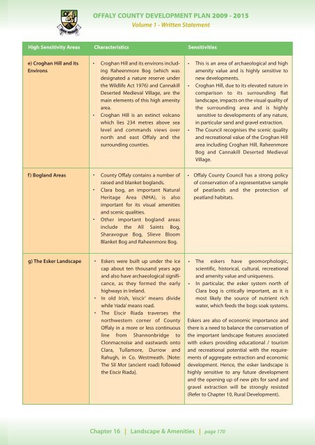
High Sensitivity Areas Characteristics Sensitivities<br />
e) Croghan Hill <strong>and</strong> its<br />
Environs<br />
•<br />
•<br />
Croghan Hill <strong>and</strong> its environs including<br />
Raheenmore Bog (which was<br />
designated a nature reserve under<br />
the Wildlife Act 1976) <strong>and</strong> Cannakill<br />
Deserted Medieval Village, are the<br />
main elements of this high amenity<br />
area.<br />
Croghan Hill is an extinct volcano<br />
which lies 234 metres above sea<br />
level <strong>and</strong> comm<strong>and</strong>s views over<br />
north <strong>and</strong> east <strong>Offaly</strong> <strong>and</strong> the<br />
surrounding counties.<br />
•<br />
•<br />
•<br />
This is an area of archaeological <strong>and</strong> high<br />
amenity value <strong>and</strong> is highly sensitive to<br />
new developments.<br />
Croghan Hill, due to its elevated nature in<br />
comparison to its surrounding flat<br />
l<strong>and</strong>scape, impacts on the visual quality of<br />
the surrounding area <strong>and</strong> is highly<br />
sensitive to developments of any nature,<br />
in particular s<strong>and</strong> <strong>and</strong> gravel extraction.<br />
The <strong>Council</strong> recognises the scenic quality<br />
<strong>and</strong> recreational value of the Croghan Hill<br />
area including Croghan Hill, Raheenmore<br />
Bog <strong>and</strong> Cannakill Deserted Medieval<br />
Village.<br />
f) Bogl<strong>and</strong> Areas •<br />
•<br />
<strong>County</strong> <strong>Offaly</strong> contains a number of<br />
raised <strong>and</strong> blanket bogl<strong>and</strong>s.<br />
Clara bog, an important Natural<br />
Heritage Area (NHA), is also<br />
important for its visual amenities<br />
<strong>and</strong> scenic qualities.<br />
• Other important bogl<strong>and</strong> areas<br />
include the All Saints Bog,<br />
Sharavogue Bog, Slieve Bloom<br />
Blanket Bog <strong>and</strong> Raheenmore Bog.<br />
• <strong>Offaly</strong> <strong>County</strong> <strong>Council</strong> has a strong policy<br />
of conservation of a representative sample<br />
of peatl<strong>and</strong>s <strong>and</strong> the protection of<br />
peatl<strong>and</strong> habitats.<br />
g) The Esker <strong>L<strong>and</strong>scape</strong> •<br />
•<br />
•<br />
Eskers were built up under the ice<br />
cap about ten thous<strong>and</strong> years ago<br />
<strong>and</strong> also have archaeological significance,<br />
as they formed the early<br />
highways in Irel<strong>and</strong>.<br />
In old Irish, ‘eiscir’ means divide<br />
while ‘riada’ means road.<br />
The Eiscir Riada traverses the<br />
northwestern corner of <strong>County</strong><br />
<strong>Offaly</strong> in a more or less continuous<br />
line from Shannonbridge to<br />
Clonmacnoise <strong>and</strong> eastwards onto<br />
Clara, Tullamore, Durrow <strong>and</strong><br />
Rahugh, in Co. Westmeath. [Note:<br />
The Slí Mor (ancient road) followed<br />
the Eiscir Riada].<br />
• The eskers have geomorphologic,<br />
scientific, historical, cultural, recreational<br />
<strong>and</strong> amenity value <strong>and</strong> uniqueness.<br />
• In particular, the esker system north of<br />
Clara bog is critically important, as it is<br />
most likely the source of nutrient rich<br />
water, which feeds the bogs soak systems.<br />
Eskers are also of economic importance <strong>and</strong><br />
there is a need to balance the conservation of<br />
the important l<strong>and</strong>scape features associated<br />
with eskers providing educational / tourism<br />
<strong>and</strong> recreational potential with the requirements<br />
of aggregate extraction <strong>and</strong> economic<br />
development. Hence, the esker l<strong>and</strong>scape is<br />
highly sensitive to any future development<br />
<strong>and</strong> the opening up of new pits for s<strong>and</strong> <strong>and</strong><br />
gravel extraction will be strongly resisted<br />
(Refer to Chapter 10, Rural Development).<br />
Chapter 16 | <strong>L<strong>and</strong>scape</strong> & <strong>Amenities</strong> | page 170


