SFRA Appendix K Figures - Runnymede Borough Council
SFRA Appendix K Figures - Runnymede Borough Council
SFRA Appendix K Figures - Runnymede Borough Council

Create successful ePaper yourself
Turn your PDF publications into a flip-book with our unique Google optimized e-Paper software.
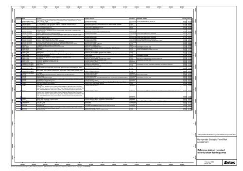
495000 496000 497000 498000 499000 500000 501000 502000 503000 504000 505000 506000 507000 508000 509000<br />
161000 162000 163000 164000 165000 166000 167000 168000 169000 170000 171000 172000 173000 174000<br />
Reference Ward Location Flooding_Source Category Remedial_Works StartX StartY<br />
Ottershaw (Murray Road, Slade Road, Wheatsheaf Close, Roefield Gardens,Fletcher<br />
0 Addlestone Bournside Road, Fletcher Close) Unnamed watercourse Watercourse Some alleviation works carried out 502842 163794<br />
1 Chertsey Meads to Addlesto Green ne Lane/Little Green Lane/beneath M25 Watercourse - culvert Watercourse 503738 165334<br />
2 Chertsey Meads N & S of Hanworth Lane Ind Estate, Hamilton Close (esp. northern branch) Watercourse backing up and flooding surface water/highway drainage Runoff 503826 166180<br />
3 Chertsey Meads Eastworth and Fordwater Roads Infiltration into foul sewers Foul sewer 504494 166363<br />
4 Chertsey South and Rowtow Rose n Park Mobile Home site<br />
5 Chertsey South and Rowtow Hare n Hill/Rowton highway junction<br />
Rutherwyck Road, Brookside, Pyrcroft Road, Chilsey Green Road, Frithwauld Road,<br />
Fluvial flooding, Addlestone Bourne<br />
Watercourse/land drainage<br />
Fluvial<br />
Runoff<br />
506549 162866<br />
503898 163634<br />
6 Chertsey St Annes Cowley Avenue Watercourse (unnamed trib of Chertsey Bourne) Watercourse 503422 166783<br />
7 Chertsey St Annes Guildford Road (St Peter's hospital entrance) Unnamed watercourse Watercourse Some capacity problems addressed 502751 164975<br />
A320 Guildford Road (junction of Holloway Hill and Green Lane, and adjacent to M25<br />
8 Chertsey St Annes overpass) Unnamed watercourse Watercourse Some capacity problems addressed 503025 165602<br />
9 Chertsey St Annes Guildford Road (at M25) Unnamed watercourse Watercourse Some capacity problems addressed 503222 166027<br />
10 Chertsey St Annes Guildford Road (Barrsbrook Farm Road) Unnamed watercourse Watercourse Some capacity problems addressed 503454 166270<br />
11 Chertsey St Annes Chertsey, btwn Chertsey Rec and Curfew Bell Road Unnamed watercourse Watercourse Flooding alleviated through revitalisation of area 503698 166457<br />
12 Chertsey St Annes Chertsey (Chertsey Rec and Sir William Perkins School playing fields) Unnamed watercourse Watercourse 503465 166414<br />
13 Chertsey St Annes Brookside, Chilsey Green Road, Erkenwald Close and Gogmore Farm Close M25 drainage (outfalls to Bourne) Runoff 503467 166965<br />
14 Chertsey Chaseside Gardens (N side of Bridge Road) Fluvial flooding, Abbey River Fluvial 504810 166893<br />
15 Egham Hythe Vicarage Road, Vicarage Crescent and Green Lane Backing up from Meadlake ditch Watercourse Unspecified remedial work 501725 171406<br />
16 Egham Hythe Albany Place Backing up along highway drainage from Meadlake Ditch/ Thames Runoff Unspecified remedial work 501530 171543<br />
17 Egham Hythe Roundway Surface runoff Runoff Pump installed but not always sufficient 502371 171073<br />
18 Egham Hythe Vicarage Crescent, Green Lane, Holbrook Meadows Infiltration into foul sewers Foul sewer 501725 171406<br />
19 Egham Town Albany Place Backing up along highway drainage from Thames Runoff 501725 171406<br />
20 Egham Town Ripley Springs area (esp. The Crescent, Ripley Avenue, Nobles Way) Springs and piped ditches. Siltation next to playing fields causing blockages. Highway Runoff drainage<br />
500478 170844<br />
21 Egham Town Milton Road, Limes Road Surface water Runoff Soakaways installed 500656 171180<br />
22 Egham Town A30 at bottom of Egham Hill, Egham Bypass and Langham Place Surface water sewer capacity Runoff 500637 171302<br />
23 Egham Town The Avenue Backing up along highway drainage from Thames Runoff Non-return valve installed to prevent backing up 501704 171722<br />
24 Egham Town Junction of Whitehall Lane and Prune Hill Unnamed watercourse and surface runoff Runoff Unspecified remedial work 500411 170185<br />
25 Egham Town Junction of Whitehall Lane and Prune Hill Infiltration into foul sewers Foul sewer 500411 170185<br />
26 Englefield Green East Highway in Tite flooding from piped section of unnamed watercourse Watercourse 499805 171280<br />
27 Englefield Green East Alder Close Highway drainage capacity Runoff Unspecified remedial work being undertaken by Highways Authority 500305 171233<br />
28 Englefield Green East Falaise Piped drainage system capacity Runoff 500481 171259<br />
Harvest Road, Parsonage Road, South Road, Alexandra Rod, Armstrong Road, Albert<br />
29 Englefield Green East Road Highway drainage capacity Runoff 499603 170942<br />
Bond Street, Vegal Crescent, Magna Road, Blays Close, Firbank Place, Schroder Court<br />
30 Englefield Green West<br />
Surface runoff from highway Runoff 498942 171070<br />
31 Englefield Green West The Green Infiltration into foul sewers Foul sewer 499175 170760<br />
32 Foxhills Slade Road and Wheatsheaf Close to Fletcher Close and Bousely Farm Unnamed watercourse Watercourse Improvement works 502951 163701<br />
33 Foxhills Foxhills Road Unnamed watercourse Watercourse 502009 164006<br />
34 Foxhills gardens in Stonehill Crescent unnamed watercourse along Stonehill Road. Can contribute to foul sewer flooding Foul sewer Unspecified remedial work 500091 163549<br />
35 Foxhills highway and gardens on Stonehill Rd at junction with Longcross Road and Holloway Hill Piped watercourse Watercourse 502172 165323<br />
36 Foxhills Almners Road and Hardwick Lane Infiltration into foul sewers Foul sewer 502347 166706<br />
37 Thorpe Mill House Lane, Mill Lane, Green Lane Fluvial flooding (Thames, Chertsey Bourne, Meadlake Ditch, Moat, Hurst Ditch) Fluvial 502014 168336<br />
38 Thorpe Delta Way (highway and carparks) Private surface water sewer capacity Runoff 502201 169586<br />
39 Thorpe Delta Way Infiltration into foul sewers Foul sewer 502201 169586<br />
Chertsey Lane, Norlands Lane, Holland Garden, Redwood, Blackett Close, Thorpside<br />
Close, Temple Gardens, Aymer Driver, Clyve Way, Mayfield Gardens, Bundies Way, TIms<br />
WAy, Ayebridges Avenue, Park Avenue, South Avenue, Warwick Avenue (And others)<br />
40 Thorpe<br />
Infiltration into foul sewers Foul sewer Improvements to Chertsey Lane South foul water pumping station and rising main 503393 169137<br />
Chertsey Lane, Norlands Lane, Holland Garden, Redwood, Blackett Close, Thorpside<br />
Close, Temple Gardens, Aymer Driver, Clyve Way, Mayfield Gardens, Bundies Way, TIms<br />
WAy, Ayebridges Avenue, Park Avenue, South Avenue, Warwick Avenue (And others)<br />
41<br />
Foul sewer 502302 170462<br />
42 Thorpe Penton Park Infiltration into foul sewers, and public sewer capacity d/s Foul sewer 504419 168680<br />
43 Thorpe Penton Hook, Riverside, Laleham Reach Infiltration into foul severs, and failure of pump system Foul sewer 504591 169027<br />
44 Virginia Water Tithe Meadows, Knoll Grove Foul sewer and highway flooding Foul sewer Surrey CC and Thames Water have undertaken works 499447 167043<br />
45 Virginia Water Oak Tree Close Unspecified Unspecified 499600 167053<br />
46 New Haw New Haw Road Groundwater Groundwater 505379 164025<br />
47 New Haw Wey Meadows Foul sewer flooding during heavy rain and high river levels Foul sewer 506385 164032<br />
Woodham Broadway, Woodham Lane, Kingston Rise, Scotland Bridge Road, Braeside,<br />
48 Woodham<br />
Lindsay Road, Kings Road, Farleigh Road Surface water sewer capacity Runoff 504451 161997<br />
49 Woodham Woodham Lock Watercourse (the Rive Ditch)/ surface runoff Runoff 503973 161296<br />
161000 162000 163000 164000 165000 166000 167000 168000 169000 170000 171000 172000 173000 174000<br />
H:\Projects\HM-255\23616 <strong>Runnymede</strong> <strong>SFRA</strong>\Drawings\ArcGIS\MXD<br />
<strong>Runnymede</strong> Strategic Flood Risk<br />
Assessment<br />
Reference table of recorded<br />
historic/urban flooding zones<br />
495000 496000 497000 498000 499000 500000 501000 502000 503000 504000 505000 506000 507000 508000 509000<br />
Based upon the Ordnance Survey Map with the permission of the Controller of Her Majesty's Stationery Office. © Crown Copyright. AL100006086<br />
February 2009<br />
23616- fiell