The unique Emu Bay Shale biota Special Report - Geological ...
The unique Emu Bay Shale biota Special Report - Geological ...
The unique Emu Bay Shale biota Special Report - Geological ...

You also want an ePaper? Increase the reach of your titles
YUMPU automatically turns print PDFs into web optimized ePapers that Google loves.
<strong>The</strong> <strong>Geological</strong> Society<br />
of Australia Inc<br />
tag<br />
Newsletter Number 153<br />
December 2009<br />
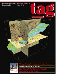
Feature: <strong>The</strong> <strong>unique</strong> <strong>Emu</strong> <strong>Bay</strong> <strong>Shale</strong> <strong>biota</strong><br />
<strong>Special</strong> <strong>Report</strong>: <strong>Geological</strong> wonders of Mars<br />
Geochronology: a personal perspective<br />
Get ready for AESC 2010
<strong>The</strong> Australian Geologist<br />
Newsletter 153, December 2009<br />
Registered by Australia Post<br />
Publication No. PP243459/00091<br />
ISSN 0312 4711<br />
Managing Editor: Sue Fletcher<br />
Technical Editor: Bill Birch<br />
Production Editor: Heather Catchpole<br />
Send contributions to: tag@gsa.org.au<br />
Central Business Office<br />
Executive Director: Sue Fletcher<br />
Suite 61, 104 Bathurst Street,<br />
Sydney NSW 2000<br />
Tel: (02) 9290 2194<br />
Fax: (02) 9290 2198<br />
Email: info@gsa.org.au<br />
GSA website: www.gsa.org.au<br />
22 From the President<br />
23 Guest Editor’s Comment<br />
24 Society Update<br />
Business <strong>Report</strong><br />
Membership Update<br />
From the AJES Editor’s Desk<br />
Education & Outreach<br />
Stratigraphic Column<br />
Heritage Matters<br />
Data Metallogenica<br />
11 AESC 2010 programme<br />
Design and typesetting <strong>The</strong> Visible Word Pty Ltd<br />
Printed by Ligare Pty Ltd<br />
Distributed by Trade Mailing & Fulfilment Pty Ltd<br />
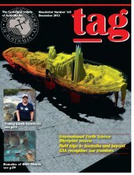
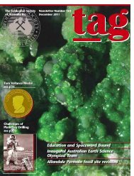
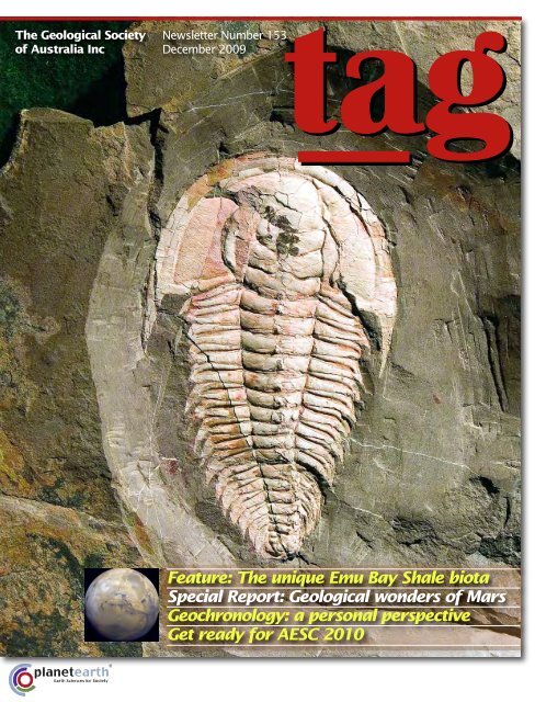
<strong>The</strong> trilobite Redlichia<br />
takooensis from the <strong>Emu</strong><br />
<strong>Bay</strong> <strong>Shale</strong>, Kangaroo<br />
Island. Specimens of this<br />
species are known to<br />
reach up to 25 cm in<br />
length. This particular<br />
specimen is 12.5 cm in<br />
length. Image courtesy<br />
John Paterson.<br />
14 News from the Divisions<br />
17 News from the <strong>Special</strong>ist Groups<br />
18 News<br />
24 Feature: <strong>The</strong> <strong>Emu</strong> <strong>Bay</strong> <strong>Shale</strong> <strong>biota</strong><br />
27 <strong>Special</strong> <strong>Report</strong>: Beyond Earth: geological wonders of Mars<br />
30 Forum: Geochronology — a personal perspective<br />
33 Book Reviews<br />
39 Letters to the Editor<br />
43 Obituaries<br />
46 Calendar<br />
47 Office Bearers<br />
48 Publishing Details
From the President<br />
Where to from here:<br />
the economy, merger and<br />
Position Statement<br />
Over the last few months there have been numerous reports from<br />
government and media sources about the strength of the<br />
Australian economy and that the worst of the global financial crisis<br />
is behind us. Australia has survived the GFC relatively unscathed: our economy<br />
managed to avoid a technical recession, unemployment has not reached<br />
the heights predicted, and consumer and business confidence (and spending)<br />
has remained remarkably buoyant. <strong>The</strong> Federal Government claims credit and<br />
undoubtedly its stimulus package reduced the impact of the financial crisis.<br />
Importantly, the national economy was in a relatively strong position at<br />
the start of the GFC (unlike countries such as the US and UK), as reflected in<br />
the Federal government budget surpluses for the last half-dozen years or so.<br />
Although the merits of these surpluses relative to limited infrastructure<br />
investment can be debated, in a large part they were built upon the strength<br />
of Australia’s fortunate geological endowment in natural resources. <strong>The</strong><br />
presence and development of these resources coincided with the rise of the<br />
emerging economies of Asia, notably China, and their almost insatiable<br />
demand for resources to satisfy both internal consumer needs and for<br />
processing into the cheap consumer goods we buy.<br />
An interesting consequence of this demand is that it has driven up<br />
commodity prices and created a scarcity of supply, resulting in activity by<br />
companies to develop the next tier down of lower-quality deposits. However,<br />
increased commodity prices within a strong economic cycle are offset by<br />
increased labour and infrastructure costs and such second-tier deposits may<br />
well remain sub-economic. GSA Executive member Jon Hronsky, in a recent<br />
article in the Business Section of <strong>The</strong> Australian newspaper ('Our prosperity<br />
depends on finding fresh resources', 12 October 2009) pointed out that our<br />
future prosperity, and hence our ability to navigate the next GFC, requires<br />
fresh resources. He noted that “the most important engine of innovation in<br />
the mining industry is greenfields exploration — the search for new worldclass<br />
mines away from current areas of production and, with this, the discovery<br />
of new, high-quality resources that can be extracted at lower costs — in<br />
terms of both capital and operating expenditure and environmental impact”.<br />
Thus, scarcity of resources leads to innovation and discovery of new, lowercost<br />
sources of mineral production. We need ongoing greenfields exploration<br />
if we are to maintain in the long term our national economic prosperity.<br />
<strong>The</strong> Position Statement by the GSA Executive Committee on climate change<br />
(TAG 152, p 31 and www.gsa.org.au/pdfdocuments/management/Greenhouse<br />
GasEmissions&ClimateChange_GSAPositionStatement_July2009.pdf) has<br />
generated a robust debate amongst our membership (see Letters section p 39).<br />
<strong>The</strong> executive has a diverse set of opinions on this issue and the document was<br />
crafted to meet that diversity. In society we are often told not to mention sex,<br />
politics and religion to avoid controversy and confrontation. Climate change is a<br />
topic that is increasingly debated with religious zeal by the protagonists and<br />
is also generating a raging national and international political debate. <strong>The</strong><br />
executive recognises that this is an emotive issue<br />
but also that it is an issue that directly relates to<br />
the Earth Sciences and that the GSA needs to be<br />
part of the debate. Importantly, we emphasised<br />
that the Earth Sciences have a pivotal role to play in better understanding the<br />
past long-term record of the Earth and that the “GSA has insufficient<br />
expertise to advise on the complex matter of short-term climate impacts”.<br />
But we also stated that we are concerned at the increasing levels of CO 2<br />
and that action should be taken to reduce output. A number of groups have<br />
made similar statements, including the Australian Academy of Science<br />
(www.science.org.au/policy/climatechange-g8+5.htm), which has endorsed<br />
the findings in the Fourth Assessment <strong>Report</strong> of the IPCC that “the increases<br />
in global average temperature and sea level are unambiguous and are almost<br />
certainly primarily due to greenhouse gas emissions”, and the American<br />
Association for the Advancement of Science (see Letters section, this<br />
issue p 39).<br />
Finally, as the majority of GSA members will now realise, the AIG<br />
Executive Council at its 16 September meeting decided to "discontinue<br />
pursuing a merger with the GSA". AIG President Martin Robinson cited the<br />
lack of support from their members in response to the circulated merger<br />
documents.<br />
I am disappointed in this outcome as I strongly believe that a merger was<br />
in the best interests of both our members and our profession. Membership by<br />
Earth Scientists is currently dispersed amongst many professional societies<br />
and represented by many societies, with the Australian Geoscience Council<br />
providing an overarching forum. This means that we do not speak with a<br />
coherent voice and I believe have considerably less influence than other more<br />
coherent groups in political and policy influence.<br />
<strong>The</strong> merger negotiations have provided an opportunity for the GSA to<br />
review its procedures and operations and the National Executive will now be<br />
using this information to evaluate the services we provide in meeting the<br />
needs of you, the members.<br />
I would like to thank my co-members of the merger committee; Andy<br />
Gleadow, Jon Hronsky and Jim Ross, who along with the society’s Executive<br />
Director, Sue Fletcher, committed a tremendous amount of time and effort<br />
towards facilitating the merger.<br />
PETER CAWOOD<br />
President<br />
2 | TAG December 2009
Guest Editor’s Comment<br />
Come to Canberra<br />
‘Come to Canberra’ is the invitation that I extend to all<br />
GSA members, indeed to all Earth Scientists, when the<br />
Australian Earth Sciences Convention is held in Canberra<br />
from 4–8 July next year.<br />
<strong>The</strong> conference will be held at the Canberra Convention<br />
Centre, in the heart of the city, within easy walking distance of<br />
a wide range of accommodation and dining options. Even the<br />
airport is only a 15 minute drive!<br />
<strong>The</strong> scientific program is organised around a similar group of<br />
themes to those used at the AECS2008 in Perth:<br />
■ Resource Security: Supporting the Nation;<br />
■ Earth’s Environments: Past, Present and Future;<br />
■ Geoscience in the Service of Society;<br />
■ <strong>The</strong> Dynamic Earth — From Crust to Core;<br />
■ Life and the Solar System;<br />
■ Topical Symposia, including <strong>Special</strong>ist Groups.<br />
Each day will begin with a high-profile Plenary Speaker, including<br />
the Mawson Lecturer. <strong>The</strong>n the program will run as six<br />
parallel sessions of oral presentations, one for each of the<br />
themes above.<br />
Program clashes are an annoying feature of some large<br />
conferences with many parallel sessions. So, we have devised a<br />
program structure that is aimed at minimising such clashes by<br />
reducing the number of parallel sessions and by scheduling<br />
keynote speakers at different times throughout the day, in<br />
each session.<br />
By reducing the number of oral presentations, poster presentations<br />
will be much more prominent in the program which is<br />
also the trend at most large international conferences these<br />
days. Authors will be allowed just one oral presentation but<br />
unlimited poster presentations. Personally, I often find posters<br />
much more rewarding than oral presentations, because there<br />
is time to take in the content in a more relaxed manner and<br />
also to discuss the poster with the author(s). Posters will be<br />
available for viewing during lunch and tea breaks, as well as in<br />
designated poster sessions.<br />
We will have the usual array of social activities, including an<br />
icebreaker on the first evening, a student event at Geoscience<br />
Australia and a Geotrivia night. A highlight of the social<br />
program will be the conference dinner, to be held in ANZAC Hall<br />
at the Australian War Memorial. ANZAC Hall houses some of the<br />
largest exhibits at the AWM, including the famous G for George<br />
Lancaster bomber, and will be a memorable dinner venue.<br />
We will also be showcasing a range of excellent local wines at<br />
the dinner.<br />
AESC2010 is offering a range of local and regional fieldtrips,<br />
including the rare opportunity to go underground at Parliament<br />
House. Or perhaps a half day trip to enigmatic Lake George<br />
(where does the water go), with a visit to nearby wineries, is<br />
more your style<br />
Early-bird registration and submission of abstracts are now<br />
open. <strong>The</strong> deadline for abstract submissions is 15 January 2010,<br />
but don’t wait until the last minute — get your abstract in now!<br />
For full details please visit the convention website:<br />
www.aesc2010.gsa.org.au<br />
BRAD PILLANS<br />
Chair, AESC2010 Organising Committee<br />
Parliament House, Canberra. Image courtesy Brad Pillans.<br />
TAG December 2009|3
SocietyUpdate<br />
Business <strong>Report</strong><br />
By now you will have received your membership renewal<br />
notice which included a 2010 member update and bonus<br />
book sale. If you haven’t received your member renewal<br />
pack or misplaced it please contact the office — the book sale<br />
is one you do not want to miss, including 50% off most of the<br />
AAP Memoirs series.<br />
Starting with the cover image I expect many palaeontologists<br />
are pleased to see the spectacular trilobite on the cover.<br />
This issue of TAG covers some of the great variety of Earth<br />
Science disciplines. <strong>The</strong> feature: <strong>Emu</strong> <strong>Bay</strong> <strong>Shale</strong> <strong>biota</strong>, Kangaroo<br />
Island: Australia’s <strong>unique</strong> window into the Cambrian world by<br />
John Paterson and Jim Jago is a change of pace for TAG; while<br />
Graziella Caprarelli’s <strong>Special</strong> <strong>Report</strong>: Beyond Earth: geological<br />
wonders of Mars will take you beyond our planet; and Alec<br />
Trendall’s personal perspective on Geochronology is sure to<br />
inspire musings, nods and possibly the odd letter to TAG.<br />
This issue the guest editor's column is from Brad Pillans,<br />
inviting you to Canberra for the upcoming AESC 2010 — don’t<br />
miss out, abstracts are now being accepted.<br />
Towards the end of the year the Divisions are active with<br />
field trips, symposia, dinners and awards. <strong>The</strong> Queensland<br />
Division are to be congratulated for their massive effort this year<br />
and for continuing to keep other GSA members outside<br />
Queensland informed — congratulations also for another truly<br />
inspirational addition to their published works with release of<br />
the Rocks and Landscapes of the National Parks of North<br />
Queensland, sure to be another hit with geologists, naturalists,<br />
bushwalkers, tourists, teachers and students. This guidebook is<br />
available for sale from the Queensland Division or the GSA office.<br />
<strong>The</strong> Victorian Division held<br />
another highly successful Selwyn<br />
symposium and if you still don’t<br />
know who was awarded the<br />
coveted Selwyn Award, read about<br />
it in this issue — a deserving recipient if ever there was one!<br />
At the time of writing, the South Australia Division in<br />
collaboration with the AIG, AusIMM and ASESG were finalising<br />
the South Australia Explorers’ Conference, an event that many<br />
members and non-members praise as an essential calendar<br />
activity. <strong>The</strong> South Australian’s also held their dinner and<br />
Awards night recently.<br />
For you other Divisions — we know you have news, we<br />
know you have been holding talks and other activities, and<br />
I encourage you to share your news with the other members —<br />
they really do want to know what you are doing. Perhaps you<br />
could send a short news item or report for the March issue,<br />
during the January downtime<br />
<strong>The</strong>re are many GSA members who shape the GSA through<br />
participation on committees, sharing knowledge and giving<br />
lectures and attending talks. You practice in similar and<br />
different disciplines, you agree and disagree, and you challenge<br />
and inspire young scientists. Well done GSA members; you are<br />
part of a very special community.<br />
Enjoy the end of year break, read a book, write a review, go<br />
into the field and remember to renew your membership so you<br />
can stay connected.<br />
Best wishes for the Season.<br />
SUE FLETCHER<br />
Executive Director<br />
ISSUE COPY FINISHED INSERTS<br />
ART<br />
MARCH 2010 29 Jan 5 Feb 8 Mar<br />
JUNE 2010 30 Apr 5 May 25 May<br />
SEPTEMBER 2010 31 Jul 8 Aug 16 Aug<br />
DECEMBER 2010 29 Oct 5 Nov 12 Nov<br />
4 | TAG December 2009
New members<br />
<strong>The</strong> GSA welcomes the<br />
following new members to<br />
the Society. May you all<br />
have a long and beneficial<br />
association with the GSA:<br />
ACT<br />
M EMBER<br />
John Mavrogenes<br />
Steven Tatham<br />
S TUDENT<br />
Brendan Hanger<br />
Oleg Koudashev<br />
NSW<br />
M EMBER<br />
Ashley Bennett<br />
Ryan Weller<br />
Ulrike Krause<br />
J OINT M EMBER<br />
Tracy Rushmer<br />
S TUDENT<br />
Claire Courtney<br />
Dylan Hvasanov<br />
Eleanor Hobley<br />
Elizabeth Teague<br />
Glen Cathers<br />
Matthew Pankhurst<br />
Thomas Bell<br />
NT<br />
S TUDENT<br />
Lee Ryal<br />
QLD<br />
M EMBER<br />
Cassie Porter<br />
Catherine Molloy<br />
Daniel James<br />
Danique Bax<br />
Derek Hatcher<br />
Graig Weston<br />
James Shulmeister<br />
Kendall Aleckson<br />
Leopoldo De Silva<br />
Matthew Davies<br />
Oscar Clark<br />
Sathan Sukumaran<br />
G R A D U AT E<br />
Alexander Willliams<br />
Brendan Mitchell<br />
Bronwyn Jones<br />
Geoffrey Cork<br />
Shannon Harris<br />
S TUDENT<br />
Andrew Kleeman<br />
Brendan Butler<br />
Peter Dean<br />
A S S O C I AT E M EMBER<br />
Anup Kujur<br />
SA<br />
S TUDENT<br />
Amanda Hopkinson<br />
Jye Kluske<br />
Shari Rankin<br />
Verity Normington<br />
TAS<br />
G R A D U AT E<br />
Thomas Jenkins<br />
VIC<br />
M EMBER<br />
Mark Rynhoud<br />
Peter Arditto<br />
S TUDENT<br />
Jozua van Otterloo<br />
Leonor Sorrentino-Mariconda<br />
Selene De Bree<br />
WA<br />
M EMBER<br />
David Tsiokos<br />
Kate Wright<br />
Max Rohrman<br />
Sarah McKie<br />
S TUDENT<br />
Alyssa Josephs<br />
Andrew Rowsell<br />
Anna Perry<br />
Bianca From<br />
Carmen Harris<br />
Casey Miller<br />
Chris Piggott<br />
Christopher Oorschot<br />
Dale Annison<br />
Daniel Bull<br />
Darren Hunt<br />
Glen Plummer<br />
Natalie Nguyen<br />
Ryan Johan<br />
Scott Drummond<br />
Shaun Davis<br />
A F F I L I AT E<br />
Albert Sequeira (AAP)<br />
Lost members<br />
For following members’ mail<br />
is being returned to the GSA<br />
office ‘return to sender/not<br />
known at this address’. Thank<br />
you to members in advance<br />
for assisting uniting members<br />
and their GSA mail.<br />
Amanda Stoltze (ACT)<br />
John Smith (VIC)<br />
Peter Henderson (QLD)<br />
Robert Morrison (SA)<br />
<br />
<br />
<br />
<br />
<br />
<br />
<br />
<br />
<br />
<br />
<br />
<br />
<br />
<br />
<br />
<br />
<br />
<br />
<br />
<br />
<br />
<br />
<br />
<br />
<br />
<br />
<br />
<br />
<br />
<br />
<br />
<br />
<br />
<br />
<br />
<br />
<br />
<br />
<br />
<br />
<br />
<br />
<br />
<br />
<br />
<br />
<br />
<br />
<br />
<br />
<br />
TAG December 2009|5
SocietyUpdate<br />
From the AJES Hon Editor’s Desk<br />
Geology and music<br />
While the Greeks regard proportions in the movements of<br />
celestial bodies — the Sun, Moon, and planets — as a<br />
form of music, I am not sure that anyone has explored<br />
the relationship between geology and music, although Gustav<br />
Holst’s suite <strong>The</strong> Planets may link the two. I imagine that rock music<br />
doesn’t count, as the rock was probably rocking to and fro, perhaps<br />
under the influence of more than just the music. <strong>The</strong> Rolling Stones<br />
also do not count as they might have rolled but were not stones —<br />
with a sphericity and roundness that you could measure. Heavy<br />
metal has more to do with massive sound than massive sulfides. So<br />
where does that leave music and geology Here are four examples.<br />
<strong>The</strong> first is a modern one. Peter Zinovieff is a pioneer of electronic<br />
and computer music. He is also a geologist who produced the<br />
first geological map of the Cuillins mountains in Skye. His EMS<br />
company made the famous VCS3 synthesiser in the late 1960s,<br />
which was used by many early progressive rock bands. He also<br />
wrote the libretto for Harrison Birtwistle's opera <strong>The</strong> Mask of<br />
Orpheus. In a talk he gave recently he tried to show that these<br />
wildly different endeavours are not so dissimilar when it comes<br />
down to the nuts and bolts of their actual creation.<br />
My second example goes back much further: <strong>The</strong> Song of a<br />
Geologist by Robert Dick (1811–1866), who was a ‘baker of<br />
Thurso’, as well as a geologist and botanist. He was a great fossil<br />
hunter and collector and wrote extensively on the fossil fish in the<br />
Old Red Sandstone. His poem was published in the John O’Groats<br />
Journal, and so pleased Sir Roderick Murchison and the eminent<br />
band of geologists belonging to the ‘Red Lion Club’ that it was<br />
sung at their annual meetings. I have no idea what the tune<br />
was — so perhaps this counts as geology and poetry rather than<br />
geology and music!<br />
Song of a geologist<br />
Hammers an’ chisels an’ a’,<br />
Chisels an’ fossils an’ a’;<br />
Sir Rory’s the boy o’ the right sort o’ stuff,<br />
Hurrah! for the hammers sae braw.<br />
It’s good to be breakin’ a stone,<br />
<strong>The</strong> work now is lucky an’ braw;<br />
It’s grand to be findin’ a bone—<br />
A fish-bone the grandest of a’.<br />
Hammers an’ chisels an’ a’,<br />
Chisels an’ fossils an’ a’;<br />
Resurrection’s our trade; by raising the dead<br />
We’ve grandeur an’ honour an’ a’.<br />
May labour be crown’d wi’ success<br />
May prudence promulgate the story<br />
May scoffers grow every day less,<br />
Till the rocks are a mountain o’ glory.<br />
Hammers an’ chisels an’ a’,<br />
Chisels an’ fossils an’ a’;<br />
<strong>The</strong> deeper we go, the more we shall know<br />
Of the past an’ the recent an’ a’.<br />
Here’s freedom to dig and to learn—<br />
Here’s freedom to think an’ to speak;<br />
<strong>The</strong>re’s nane ever grumbled to look at a stone,<br />
Aye but creatures ’baith stupid an’ weak.<br />
Hammers an’ chisels an’ a’,<br />
Chisels an’ fossils an’ a’;<br />
In spite of the devil we’ll dig as we’re able<br />
Hurrah! for the hammers sae braw.<br />
My third example truly qualifies as geology and music (or geophysics<br />
and music if you prefer). Earthquake Quartet #1 for voice, trombone,<br />
cello and seismograms, was composed by Andrew Michael. He<br />
describes it as an outgrowth of a lecture he has been giving since<br />
1997 entitled ’<strong>The</strong> music of earthquakes’, which mixes performance<br />
and lecture, music and science, acoustic instruments and computergenerated<br />
sounds. This piece had its premiere on 16 December 1999<br />
at the annual Fall meeting of the American Geophysical Union. <strong>The</strong><br />
musicians at the premiere were soprano and USGS geophysicist<br />
Stephanie Ross, cellist and Stanford University geophysics graduate<br />
student David Schaff, and trombonist and USGS geophysicist Andrew<br />
Michael — truly mixing geology and music.<br />
Finally, a home-grown example. At the beginning of the<br />
International Year of Planet Earth (IYPE) students from 18 to 27 years<br />
of age were invited to participate in the IYPE Student Contest to produce<br />
an original written work (English or French) such as an article,<br />
essay or poem related to the IYPE theme ‘Earth Science for Society’ or<br />
to any of the ten IYPE topics. In February 2008, Lachlan O'Brien was<br />
selected as Australia's winner of the contest for his musical piece,<br />
Rondo Symbiosis — <strong>The</strong> rhythm of life. Lachlan attended the official<br />
international launch of IYPE in Paris, along with leading scientists and<br />
government representatives from 191 United Nations member<br />
countries. You can listen to the music on the GSA website (go to<br />
www.gsa.org.au/recognition/geo-awards.html and click on downloads<br />
under IYPE) and you will get the mp3 file and an accompanying<br />
document explaining the piece. Lachlan describes his composition as<br />
“An avant-garde piece of orchestral music serving as a metaphysical<br />
representation of the origin and evolution of life on the planet Earth.”<br />
TONY COCKBAIN<br />
Hon Editor AJES<br />
6 | TAG December 2009
SocietyUpdate<br />
Education&Outreach<br />
This year is rapidly drawing to a close, and in heralding<br />
in the new year, I would like to observe that 2010<br />
should be a memorable one for Earth Sciences in<br />
Australian schools. <strong>The</strong> first review of the proposed Year 11–12<br />
science curriculum draft has been conducted and the GSA was<br />
part of this review, ably represented by long-time member and<br />
member of the GSA Education <strong>Special</strong>ist Group, Len Altman.<br />
Len was of the opinion that the first draft was something of a<br />
backward step for the Earth Sciences as they are taught in<br />
South Australia, where he teaches, although a big improvement<br />
for States that teach nothing at all at the senior level.<br />
However, it is also clear that a nationally recognised Year<br />
11–12 Earth and Environmental Science course is a major step<br />
forward for us all. As the Australian Curriculum, Assessment<br />
and <strong>Report</strong>ing Authority (ACARA) listens to the opinions of the<br />
GSA and addresses all the concerns raised in stakeholder meetings,<br />
2010 promises to be the best year yet for reversing the<br />
drift away from Earth Science teaching at senior level in<br />
schools. Just how much Earth Science will be in the mix, and<br />
whether it satisfies those already teaching Earth Science at<br />
senior level in South Australia remains to be seen.<br />
<strong>The</strong> Prime Minister’s Science<br />
Prize for Excellence in Teaching in<br />
Secondary Schools<br />
In mentioning the assistance the GSA received from Len<br />
Altman in reviewing the senior curriculum draft, I have already<br />
introduced the reader to a true champion of the Earth<br />
Sciences. Len, an experienced geologist, has been a dedicated<br />
teacher of Earth Sciences in South Australia for many years.<br />
He has also been very active in promoting the discipline<br />
and the career pathways it provides in many innovative ways,<br />
including the establishment of the Geoscience Pathways website<br />
and his coordination of the South Australian operations of<br />
the Teacher Earth Science Education Programme (TESEP), both<br />
of which the GSA has proudly supported in recent years.<br />
It is therefore with great pleasure that I relay to the GSA<br />
membership and Len’s peers the fact that Len has recently been<br />
recognised for his efforts and awarded with the Prime<br />
Minister’s Science Prize for Excellence in Teaching in<br />
Secondary Schools, made annually to a teacher who has made<br />
an outstanding contribution to science education in Australia.<br />
<strong>The</strong> award, presented to Len by the Prime Minister in Canberra,<br />
could not have gone to a more deserving recipient. Len exemplifies<br />
everything we as a community need in a teacher, and<br />
this has been recognised by his own community for some time.<br />
At his own school, Marden Senior College, there are now more<br />
students in geology and geoscience than any other school in<br />
South Australia. <strong>The</strong> award not<br />
only comes with a medallion and its<br />
associated kudos but also with a<br />
$50 000 grant. Congratulations Len!<br />
Len also acts as a mentor to trainee<br />
teachers and it is this cohort of teachers, entering the<br />
profession for the first time, that we must nurture and support.<br />
Len is leading by example, both as a geologist and a teacher,<br />
and I encourage all GSA members to follow Len's lead and<br />
assist teachers in your own community to teach science and<br />
especially Earth Science. Without teachers of the highest<br />
calibre, students will further disengage from science and the<br />
Earth Sciences will be the poorer for it.<br />
See https://grants.innovation.gov.au/SciencePrize/Pages/Doc.<br />
aspxname=previous_winners/PM2009Altman.htm for full<br />
details of the award.<br />
GREG McNAMARA<br />
Education and Outreach<br />
Send all comments to Greg McNamara at<br />
outreach@gsa.org.au<br />
<strong>The</strong> Australian Journal of Earth<br />
Sciences seeks new Editor<br />
After many years of stewardship Tony Cockbain is<br />
stepping down as Editor-in-Chief of AJES.<br />
AJES is the GSA’s flagship publication, comprising<br />
eight issues per year. AJES has an Editorial Board,<br />
consisting of the GSA President, Vice-President, a<br />
senior Earth Scientist and the Editor-in-Chief, and<br />
up to 24 associate editors who serve three-year<br />
terms.<br />
<strong>The</strong> journal will soon move to an online submission<br />
environment and greater use of technology will be<br />
introduced and supported through the Sydney office.<br />
This will be an exciting new chapter in the development<br />
of AJES — the premier international geoscience<br />
journal produced in Australia.<br />
If you are interested please contact Peter Cawood<br />
for a position description.<br />
pcawood@fnas.uwa.edu.au<br />
TAG December 2009|7
SocietyUpdate<br />
Stratigraphic Column<br />
Defining Igneous Units and other things<br />
In October I was invited to a New South Wales <strong>Geological</strong><br />
Survey mapping workshop in Orange to talk about how we<br />
define lithostratigraphic units in Australia. Of course, this<br />
was mostly revision for the Survey geologists, but it was also a<br />
great opportunity for me to see some rocks and regolith first<br />
hand, and to see how geologists operate in the digital age. We<br />
were able to look at examples and discuss as a group how to<br />
deal with various aspects of defining units. I’d like to share<br />
some of the discussion with TAG readers.<br />
Firstly, a reminder or three:<br />
■ lithostratigraphy is the element of stratigraphy that deals<br />
with the description and systematic organisation of rock<br />
bodies into units, on the basis of lithological properties<br />
(Salvador (Ed) 1994, International Stratigraphic Guide).<br />
This applies to any kind of rock body, not just sediments;<br />
■ any existing defined unit can be redefined to take account<br />
of new data (geophysical, drill core, fossil or radiometric<br />
dating etc), and if there are undefined units in common<br />
use in an area you are mapping, you can define them<br />
(acknowledging the previous work done);<br />
■ the guidelines, definition form and approval process for<br />
defining units are there to help you communicate your very<br />
valuable observations as clearly as possible. <strong>The</strong>y are intended<br />
to provide advice and peer review rather than a bureaucratic<br />
hurdle.<br />
We spent some time talking about the importance of type sections<br />
and type areas, and how useful they are as typical examples<br />
for geologists new to an area, and how the lack of a type<br />
section can lead to confusion and contention. <strong>The</strong> various uses of<br />
Adaminaby over the years and over various map sheets and State<br />
borders was raised. Splitters and lumpers will have different<br />
views, but good unit definitions should make consensus easier.<br />
Other discussion points included:<br />
■ the value of making definitions available for digital download<br />
through the Australian Stratigraphic Units Database, as<br />
well as in a publication. Any published source will always be<br />
acknowledged in the database;<br />
■ why it is important to give reasons for the age of a unit, or<br />
provide reference details for more information, rather than<br />
just baldly state an age;<br />
■ when to use lithological terms vs Formation When there is<br />
a dominant lithology.<br />
We also covered various aspects of igneous units such as:<br />
■ do existing names have to be changed to conform with IUGS<br />
nomenclature Only if misleading, or if redefining the unit,<br />
but new unit names should certainly follow current IUGS<br />
guidelines;<br />
■ what proportion of volcaniclastics can you have in a Volcanic<br />
Group It depends on whether they are demonstrably primary<br />
volcanics or not. If not, they should only be a minor component;<br />
■ can you include high-level intrusives in volcanics Yes, it has<br />
been done in NSW;<br />
■ how is a suite defined An igneous suite is a group of<br />
igneous units with common textural, mineralogical and<br />
compositional characteristics, or a sequence of such<br />
characteristics, based initially on field, then on petrographic,<br />
and finally on compositional data. It is the analogue of a<br />
lithostratigraphic group, except that one of the constituents<br />
is designated the ‘type’ for a suite (or supersuite). <strong>The</strong> ages<br />
of constituent units do not have to be part of the criteria for<br />
allocating them to a suite/supersuite. However, setting up a<br />
suite/supersuite implies that the constituents are at least<br />
cogenetic, although not necessarily comagmatic. New<br />
suites/supersuites should not use the same geographic name<br />
as any of their constituents, but renaming of existing suites<br />
and supersuites is not required;<br />
■ do you have to group igneous units No. Suite nomenclature<br />
need only be used where it has practical value. If there is<br />
insufficient information to group them, intrusive units should<br />
remain ungrouped. <strong>The</strong> use of subsuites is discouraged, as<br />
is the creation of suites and supersuites with only one<br />
constituent unit;<br />
■ the term ‘Complex’ can be used where field work establishes<br />
that there have been complex multiple intrusions, variable<br />
contamination, or diverse types of igneous rock irregularly<br />
mixed or with highly complicated relations, such that the<br />
components or their order of formation cannot be readily<br />
mapped. ‘Complex’ can also be used for mixed metamorphic<br />
units and complicated sedimentary units such as melanges.<br />
As something already under consideration in other States such as<br />
the Northern Territory and Western Australia, I also introduced<br />
the topic of Large Igneous Provinces (LIPs), and whether the<br />
components should be linked using suite nomenclature, or left as<br />
provinces. In NSW this question is unlikely to arise until a lot<br />
more of the Cenozoic basalts are better characterised geochemically<br />
and dated, but the matter is more pressing elsewhere.<br />
I’m always on the look out for opportunities to talk to<br />
people face to face, so please let me know about any workshops<br />
or meetings that I might attend in your area, or any<br />
stratigraphic feedback you have.<br />
CATHY BROWN<br />
National Convenor, Australian Stratigraphy Commission<br />
c/- Geoscience Australia<br />
GPO Box 378, Canberra, ACT, 2601<br />
cathy.brown@ga.gov.au or cathyeb@netspeed.com.au<br />
Guidelines on defining lithostratigraphic units are available<br />
from links on: www.ga.gov.au/oracle/stratnames/index.jsp<br />
8 | TAG December 2009
SocietyUpdate<br />
Heritage Matters<br />
As I pondered what is important for this issue’s TAG<br />
column, the excellent and free journal Earth Heritage<br />
arrived from the UK. This journal is published twice<br />
yearly by the Joint Nature Conservation Committee, Natural<br />
England Scottish Natural Heritage and the Countryside Council<br />
for Wales. This issue has articles on geoconservation and the<br />
climate, geology trusts, the open day at British <strong>Geological</strong><br />
Survey, landscapes and wallpaper, geodiversity in Scotland and<br />
information on museums. <strong>The</strong> back issues can be downloaded<br />
from the website http://home.btconnect.com/ seaburysalmon/<br />
and follow the prompts to Earth Heritage. Any one interested<br />
can also contact the editor to be put on the mailing list.<br />
<strong>The</strong> article that really caught my eye was on cave<br />
conservation. As many of you know, caves and karst are a<br />
particular passion of mine, so an article about a project to use<br />
cavers to monitor caves registered as SSSI (Sites of Scientific<br />
Significance) was of immediate interest. Regular monitoring of<br />
the SSSI is carried out by Natural England staff as a rule, but<br />
few are experienced or trained for underground work, especially<br />
in the non-tourist caves or sections of caves.<br />
Monitoring of sites is something that is done very poorly in<br />
Australia. Few agencies see it as part of their role and merely<br />
bemoan degradation. Even in the more-regularly visited<br />
National and State parks, where management is very evident,<br />
degradation is poorly understood or managed. A case in point<br />
is the Loch Ard Gorge area in Port Campbell National Park,<br />
Victoria, where graffiti is still being carved into soft rock near<br />
the steps and on the cliffs on the beach (see photo). Although<br />
things have improved over the past five years, and cleaning<br />
back of such damaged areas has occurred, when I visited in<br />
October 2009, I noticed there were still some 2009 dates<br />
carved into the rock. <strong>The</strong> use of trained volunteers to assess the<br />
status of sites is a way of dealing with budget constraints as<br />
well as fostering improved awareness of the fragility of some<br />
sites.<br />
Nevertheless, these sites include some major tourist<br />
attractions and their geological values are often poorly<br />
presented to the general tourist public. <strong>The</strong> situation is better<br />
in some States than others. Victoria is particularly bad in this<br />
regard; but work done by GSA members in other States has<br />
been more successful. We need to value our iconic sites as well<br />
as the more mundane sites. <strong>The</strong> overuse of shotcrete and<br />
vegetation on the battered edges of road cuttings are a case in<br />
point.<br />
Last month the Victorian Division awarded its prestigious<br />
Selwyn Medal to Bernie Joyce. Bernie has been a stalwart<br />
advocate for <strong>Geological</strong> Heritage and conservation for several<br />
decades. His hard work continues in retirement but it is good to<br />
see the society recognising his contribution to geology.<br />
Congratulations Bernie!<br />
SUSAN WHITE<br />
Graffiti carved in soft limestone, Loch Ard Gorge Victoria, photographed<br />
4 October 2009. Image courtesy Nicholas White.<br />
TAG December 2009|9
SocietyUpdate<br />
Data Metallogenica<br />
Allan White’s legacy: the Australian Geoscience <strong>The</strong>sis Database<br />
Although probably best known for his work on granites<br />
with Bruce Chappell, the late Allan White was also the<br />
energy and originator behind assembling the<br />
Australian Geoscience <strong>The</strong>sis Database. Together with his colleague<br />
Amarendra Changkakoti at the University of Melbourne,<br />
he developed the first fully comprehensive listing of Australian<br />
geoscience theses through AMIRA International project P874.<br />
Allan White’s legacy in this enterprise will long be<br />
remembered and should be gratefully acknowledged by all<br />
Australian geologists for many generations to come.<br />
In some ways, it is astounding that such a listing had not<br />
been developed before to maximise the value of previous<br />
Australian thesis research. However, the compilation was not<br />
only completed but is now available to geoscientists worldwide<br />
through the Geoscience <strong>The</strong>sis Database button on the home<br />
page of AMIRA’s Data Metallogenica website<br />
www.datametallogenica.com.<br />
<strong>The</strong> project was sponsored by a number of Australian<br />
companies and geological surveys, including Anglo American,<br />
BHP Billiton, Copperstrike, NSW Department of Primary<br />
Industries, Fugro, GSWA, Newcrest, Newmont, NTGS, Oxiana,<br />
Perilya, PIRSA, Rio Tinto, Terra Search, Xstrata, Vale and Zinifex;<br />
it was completed in late 2007. An update will be completed<br />
in 2010.<br />
Some quick facts on the database:<br />
■ over 10 500 thesis citations from 24 universities, including<br />
departments now closed;<br />
■ over 1600 abstracts of economic geology theses;<br />
■ the oldest thesis listed is <strong>The</strong> continental geology of Fiji by<br />
WG Woolnough from 1904;<br />
■ the greatest number of theses derive from the University of<br />
Sydney (1111), followed by the University of Adelaide (980)<br />
and the University of Western Australia (979);<br />
■ over 750 theses focus on areas outside Australia;<br />
■ almost 1000 theses have geophysical topics, and more than<br />
800 have structural geology topics;<br />
■ approximately 800 theses deal with gold, 400 with copper<br />
and 300 with zinc.<br />
<strong>The</strong> database can be quickly and easily searched using a range<br />
of criteria. Basic listings by author, date, thesis type, university<br />
and title are free to the public through the website, which all<br />
GSA members are encouraged to visit and use. <strong>The</strong> “free text”<br />
search option is particularly useful when titles are not fully<br />
known.<br />
Sponsors of the original P874 project (and also subscribers<br />
to Data Metallogenica) are able to perform more sophisticated<br />
searches by including:<br />
■ mineral commodities;<br />
■ over 30 science disciplines (eg igneous geology, hydrocarbon<br />
geology, palaeontology, geochemistry, volcanology);<br />
■ the Australian State or overseas country where the research<br />
was focused;<br />
■ abstracts for economic geology theses.<br />
We are grateful to those who contacted us in the last year or<br />
so to add missing theses or provide corrections, and trust this<br />
will continue in order to maintain the currency of the database<br />
into the future.<br />
We believe that GSA members will find this asset of great<br />
relevance, whatever their field of geoscience.<br />
Please note that members of the <strong>Geological</strong> Society of<br />
Australia pay only $110 pa (inc GST) for individual (personal)<br />
subscriptions to DM: half price. DM is not-for-profit and your<br />
contributions go directly to maintenance and development of<br />
the database and to providing you with a better service and<br />
faster growth.<br />
For more information please contact: Alan Goode, DM<br />
Project Director, AMIRA International<br />
(alan.goode@amirainternational.com; ph 03 8636 9957).<br />
ALAN GOODE<br />
DM Project Director<br />
AMIRA International<br />
10 | TAG December 2009
Australian Earth Sciences Convention<br />
AESC 2010 Earth systems:<br />
change, sustainability, vulnerability<br />
4–8 July 2010, Canberra<br />
<strong>The</strong> GSA invites you to Canberra to<br />
attend the AESC 2010.<br />
<strong>The</strong> AESC has six main themes:<br />
■ Dynamic Earth: from crust to core<br />
■ Earth's Environments: past, present and<br />
future<br />
■ Life and the Solar System<br />
■ Geoscience in the Service of Society<br />
■ Resource Security: supporting our<br />
nation<br />
■ Topical<br />
Plenary speakers<br />
Belinda Robinson, CEO of Australian<br />
Petroleum Production & Exploration<br />
Association Limited (APPEA);<br />
Martin Brasier, Professor of<br />
Palaeobiology, Oxford University;<br />
Mawson Lecturer (to be announced).<br />
<strong>The</strong>me: Dynamic Earth:<br />
from crust to core<br />
Co-convenors: Russell Korsch, Geoscience<br />
Australia; Peter Cawood, University of<br />
Western Australia and Nick Rawlinson,<br />
Australian National University.<br />
Geodynamic evolution of Australia<br />
from Archean cratons to Quaternary<br />
basins<br />
<strong>The</strong> Australian continent consists of a<br />
fascinating amalgamation of terranes<br />
that spans the geologic time scale. What<br />
roles have the various tectonic processes,<br />
including intracratonic and interplate,<br />
played in its assemblage How has it<br />
been affected by the formation and<br />
breakup of past supercontinents Have<br />
surface processes influenced the<br />
architecture of the lithosphere How are<br />
neotectonic processes shaping the<br />
contemporary landscape <strong>The</strong>se and<br />
many other questions fall within the<br />
realm of most subdisciplines of the Earth<br />
Sciences.<br />
<strong>The</strong> restless Earth: plate tectonics,<br />
mantle dynamics and core processes<br />
This session covers a diversity of topics,<br />
from inner core evolution, the nature of<br />
the geodynamo, the coupling of mantle<br />
circulation and plate tectonic processes.<br />
Recent insights from geodynamic<br />
modelling constrained by multidisciplinary<br />
datasets are particularly<br />
welcome.<br />
Intracratonic processes in<br />
lithospheric evolution<br />
Although plate margins play a significant<br />
role in the shaping of continents,<br />
intracratonic processes can also have a<br />
major impact (eg the Alice Springs<br />
Orogeny of central Australia). Issues that<br />
could be addressed include the<br />
importance of convective instability of<br />
the mantle lithosphere versus far field<br />
forces in driving an intracratonic event;<br />
the role of pre-existing structures such<br />
as faults and terrane boundaries in the<br />
accommodation of deformation;<br />
deciphering the nature of intraplate<br />
deformation from interplate-related<br />
deformation, and the subsidence<br />
mechanism for intracontinental basins.<br />
Understanding Earth structure using<br />
geophysical and geochemical<br />
techniques<br />
<strong>The</strong> rapid development of new<br />
techniques, coupled with increases in<br />
computing power and improved data<br />
acquisition, have allowed geophysicists<br />
to illuminate the deep Earth with<br />
unprecedented resolution using a variety<br />
of methods such as seismic (eg reflection<br />
and refraction profiling, tomography) and<br />
magnetotellurics. Similarly, improved<br />
geochemical analyses of rocks now<br />
exposed at the Earth's surface provide<br />
valuable constraints on the composition<br />
of the deep crust and mantle. Together<br />
with recent results from rock physics, we<br />
are now on the brink of being able to<br />
elucidate the physical and chemical state<br />
of the Earth's interior in great detail.<br />
Linking geodynamics to minerals<br />
and energy resources<br />
<strong>The</strong> formation of mineral and energy<br />
resources can often be linked to<br />
concurrent geodynamic processes which<br />
affect the entire lithosphere. For<br />
example, the metallogenic Macquarie Arc<br />
in New South Wales probably formed as<br />
a result of magmatism associated with<br />
the evolution of an intraoceanic island<br />
arc. Understanding such processes can<br />
help provide new insight into the<br />
creation of these resources.<br />
<strong>The</strong>me: Earth's Environments:<br />
past, present and future<br />
Co-convenors: Patrick De Deckker,<br />
Australian National University; Brad<br />
Opdyke, Australian National University;<br />
Lisa Worrall, Geoscience Australia and<br />
Neville Exon, Australian National<br />
University.<br />
High-resolution geological archives<br />
of past climate change.<br />
<strong>The</strong>re is an urgent need to gather highresolution<br />
information from natural<br />
archives, especially for the Holocene, a<br />
period of time which saw significant<br />
climatic shifts, sometimes even very<br />
rapid ones. Marine as well as terrestrial<br />
archives that are well dated can thus be<br />
compared and inform us on past climatic<br />
phenomena of direct relevance to<br />
climate modellers and environmental<br />
managers.<br />
TAG December 2009|11
Water resources, viability and threats,<br />
with emphasis on groundwater<br />
Water is arguably our most precious<br />
resource, and it is essential that we<br />
understand the distribution, movement<br />
and quality of groundwater and surface<br />
water. Groundwater is an integral<br />
component of the hydrologic cycle, and<br />
we need to understand recharge and<br />
transport rates, interactions with surface<br />
water, ages and the impacts of climate<br />
change and anthropogenic activities in<br />
rural and urban areas.<br />
<strong>The</strong> Australian arid–semiarid zone:<br />
processes, changes and long-term<br />
history<br />
With the current climatic scenarios of<br />
increasing drought over a large part of<br />
Australia, there is a need to define past<br />
climatic shifts that affected the<br />
boundary between the arid and semiarid<br />
zones of this continent. We need to<br />
determine the shifts that occurred in the<br />
past, the rates of change and relevant<br />
amplitudes. Such information will be of<br />
great relevance for predicting future<br />
climatic shifts and trends that will affect<br />
vegetation and the nature of the<br />
regolith, including groundwater and<br />
surficial water.<br />
<strong>The</strong> IODP and the marine record in the<br />
Australian region<br />
Australia has recently rejoined the<br />
Integrated Ocean Drilling Program. <strong>The</strong><br />
meeting will take place soon after the<br />
IODP Expedition 325 (Great Barrier Reef<br />
Environmental Changes) and papers on<br />
this expedition and other IODP<br />
expeditions are invited.<br />
<strong>The</strong> Brian Logan Symposium<br />
Brian Logan was an influential<br />
sedimentary geologist in WA over many<br />
years. This symposium is designed to<br />
give students and friends of Brian an<br />
opportunity to present research<br />
influenced by his work.<br />
<strong>The</strong>me: Life and the Solar System<br />
Co-convenors: Graziella Caprarelli,<br />
University of Technology; David Wacey,<br />
University of Western Australia and Marc<br />
Norman, Australian National University.<br />
Keynote speakers include:<br />
■ Malcolm Walter, UNSW: ‘Oxygenating<br />
the Earth: were Archean stromatolites<br />
constructed by cyanobacteria’;<br />
■ Jennifer Heldmann, NASA Ames:<br />
‘Latest results from NASA's LCROSS<br />
(Lunar Crater Observation and Sensing<br />
Satellite) Mission: exploring the permanently<br />
shadowed craters of the Moon's<br />
South Pole’;<br />
■ Kliti Grice, Curtin University: ‘Novel<br />
approaches to investigating major events<br />
in the evolution of life’;<br />
■ Mark Van Zuilen, University of Bergen,<br />
Norway: ‘21st century advances in the<br />
study of Archean life’.<br />
<strong>The</strong> Pilbara Archean Drilling Project —<br />
an update<br />
Following on from the highly successful<br />
session at AESC 2008, contributions<br />
detailing putative signs of life and clues<br />
to early Earth environments are<br />
particularly welcome.<br />
21st century advances in the study of<br />
Archean life<br />
<strong>The</strong> last decade has seen an explosion of<br />
new techniques and significant<br />
improvements in techniques that have<br />
greatly aided the study of Archean life.<br />
We welcome research using (but not<br />
limited to) SIMS, TEM, SEM, synchrotron<br />
radiation, lasers, and molecular<br />
techniques.<br />
Stromatolites past and present<br />
This session aims to bring together<br />
researchers investigating both modern<br />
and ancient stromatolites and microbial<br />
mats to increase our understanding of<br />
stromatolite ecosystems and better<br />
evaluate the biogenicity of ancient<br />
examples.<br />
Novel approaches to investigating<br />
major events in the evolution of life<br />
Contributions that elucidate key<br />
moments, conditions, or events that<br />
exerted a major influence on the<br />
evolution of life are invited. This could<br />
include contributions in palaeontology,<br />
palaeoecology, geobiology and<br />
geochemistry, and encompassing all<br />
periods of Earth history.<br />
Australian analogues of Mars<br />
<strong>The</strong> Australian continent provides useful<br />
physical and geological analogues that<br />
can help us understand the processes<br />
that shaped the surface of Mars.<br />
<strong>Geological</strong> and geomorphological<br />
analyses of Martian and Australian<br />
landscapes, descriptions of analogue<br />
field programs, and developments in<br />
robotic exploration and analysis would<br />
be especially suitable.<br />
Planetary systems and habitability<br />
<strong>The</strong>se sessions seek to present an<br />
integrated view of the formation and<br />
early evolution of planets and related<br />
bodies. We invite presentations that use<br />
geochemical or geophysical data,<br />
numerical models, or interpretation of<br />
mission datasets to clarify the structure<br />
and temporal evolution of nebular disks,<br />
planet formation and early<br />
differentiation, volcanism, tectonism,<br />
surface processes, and planetary<br />
atmospheres. Contributions that<br />
examine the astonishing diversity of<br />
planets, including rocky bodies, gas and<br />
ice giants, comets, meteorites, and<br />
exoplanets, and fundamental aspects of<br />
habitability are welcome.<br />
<strong>The</strong> impact of impacts<br />
Australia has some of the most ancient<br />
crust on Earth, where meteoritic impacts<br />
have left their marks throughout its<br />
history. Descriptions and models of<br />
impact crater morphologies, the impact<br />
process, and the effects of impacts on<br />
planetary environments are invited.<br />
12 | TAG December 2009
Planetary science and education<br />
This session seeks to raise the awareness<br />
of planetary science as a vehicle for<br />
science education, and to link with other<br />
education sessions at the conference.<br />
Open sessions that include workshop<br />
activities will be considered.<br />
<strong>The</strong>me: Geoscience in the Service<br />
of Society<br />
Co-convenors: Dianne Tompkins, CSIRO<br />
Exploration & Mining; Phil Cummins,<br />
Geoscience Australia and Paul Tregoning,<br />
Australian National University.<br />
Oral and poster presentations are<br />
welcome across the broad theme,<br />
including geological hazards, education,<br />
geotourism etc. Planned symposia<br />
include:<br />
New science for a changing natural<br />
hazard landscape<br />
One of the most important ways in<br />
which Earth Science contributes to<br />
society is through an appreciation of<br />
natural hazards and their consequences.<br />
Hazard profiles have changed<br />
dramatically in recent years, due to<br />
changes in both our perception of<br />
geological hazards with long recurrence<br />
times, as well as actual changes in<br />
meteorological hazards driven by climate<br />
change. <strong>The</strong> potential consequences are<br />
also changing rapidly, with the 20thcentury<br />
population explosion leading to<br />
increased concentrations of vulnerable<br />
people in areas exposed to natural<br />
hazards. How can Earth Scientists<br />
respond to these by changing the way<br />
we do science and ensuring our<br />
knowledge is utilised for the public<br />
good<br />
This symposium will cover specific<br />
natural hazard and risk assessment case<br />
studies, adaptation of existing<br />
investigative techniques to informing<br />
communities of hazards as well as the<br />
development and use of new tools for<br />
studying and identifying natural hazards.<br />
Education<br />
Earth Science education is critical for<br />
students at all levels from kindergarten<br />
through to tertiary education. From a<br />
young age, students need to understand<br />
something of the world around them on<br />
a local, regional and global scale and<br />
how the Earth’s systems work. In<br />
addition, they need to understand the<br />
effect that human habitation has had on<br />
these systems and what can be done,<br />
where necessary, to minimise the<br />
impact. This ensures that the next<br />
generation of decision makers and<br />
leaders is sufficiently knowledgeable to<br />
make informed decisions no matter what<br />
their job, career choices and lifestyle.<br />
As a consequence of exposure to these<br />
ideas and topics at primary and middle<br />
schools one of many positive benefits is<br />
that more high school students will have<br />
the information they need to decide to<br />
take up the option to study Earth and<br />
Environmental Sciences in Years 11 and<br />
12 and at a tertiary and research level if<br />
they so wish. This subtheme seeks to<br />
explore the different pathways to<br />
increasing and supporting Earth Science<br />
education and how individuals and<br />
organisations can support this<br />
endeavour. In a country with a large<br />
resource-based economy it is important<br />
that everyone has a basic understanding<br />
of where and how the wealth and jobs<br />
are generated, and also how to make<br />
responsible decisions for themselves,<br />
their community and their world.<br />
<strong>The</strong>me: Resource Security:<br />
supporting our nation<br />
Co-convenors: Frederick Cook,<br />
EARTHECONX; Barry Fordham, FrOGTech;<br />
David Giles, University of Adelaide;<br />
John Mavrogenes, Australian National<br />
University and Greg Corbett, Australian<br />
Institute of Geoscientists.<br />
Keynote Speaker: David Campbell, Vice<br />
President, Exploration, Waratah Coal:<br />
Galilee Basin development (tbc).<br />
Exploration geosciences<br />
Includes precompetetive data, decision<br />
making in exploration (concept-datadiscovery),<br />
and deep exploration<br />
(targetting and technologies).<br />
Mineral systems<br />
Commodity specific, eg gold, base<br />
metals, IOCG, porphyry Cu–Au, as well as<br />
process specific, eg magmatic,<br />
hydrothermal/orogenic,<br />
hydrothermal/basins etc.<br />
Energy — Oil and gas, coal,<br />
geothermal and uranium<br />
Uranium Mineral Systems: geology and<br />
exploration (Convenors: Subhash Jaireth,<br />
Roger Skirrow). <strong>The</strong> presentations will be<br />
by researchers based at universities,<br />
CSIRO, geological surveys and<br />
exploration companies. <strong>The</strong>re will be<br />
one session exclusively on exploration<br />
techniques and the rest will be on<br />
the geology of major uranium systems/<br />
deposits.<br />
AIG Symposium<br />
One-full day symposium<br />
<strong>The</strong>me: Topical<br />
<strong>The</strong> five themes will be supplemented by<br />
a Topical strand that can accommodate a<br />
full-day or half-day symposium<br />
including:<br />
Palaeomagnetism — Phil Schmidt, CSIRO<br />
Exploration & Mining<br />
AuScope — Bob Haydon, AuScope.<br />
<strong>The</strong> remaining sessions are open to<br />
<strong>Special</strong>ist Groups whose activities are<br />
not included in the main program.<br />
Abstracts close:<br />
15 January 2010<br />
Join us in Canberra<br />
4–8 July.<br />
www.aesc2010.gsa.org.au<br />
TAG December 2009|13
News from the divisions<br />
Queensland<br />
Geoscience at the EKKA!<br />
For the second time, the GSA, Qld Division and<br />
AIG, Qld Branch combined to run an event<br />
promoting geoscience in the community as part<br />
of National Science Week in August 2009.<br />
As in 2008, the Queensland National Science<br />
Week Coordinating Committee organised the<br />
National Science Festival which ran at the<br />
Brisbane Showgrounds from the 6–15 August<br />
2009. <strong>The</strong> AIG and GSA combined to run a<br />
joint exhibition booth in the Science Pavilion,<br />
alongside CSIRO, QUT, UQ, Young Scientists of<br />
Australia and other organisations.<br />
While again this was a huge undertaking for<br />
GSA/AIG, the EKKA subcommittee was able to<br />
incorporate all the previous preparation work,<br />
posters and materials, last year’s improvement<br />
suggestions and experiences to assemble an<br />
even more interesting display aimed at the<br />
general public, both young and old, promoting<br />
the importance and value of geoscience in the<br />
community. Various volunteers and supporters<br />
provided stunning specimens to attract people<br />
from all walks of life to “feel and touch” geoscience.<br />
School classes showed a strong interest in<br />
our “hands-on” display.<br />
Booth ready for business: setup done by<br />
Gregg Webb, Friedrich von Gnielinski, Mark Berry<br />
and Paul Blake.<br />
Top attractions on the two spacious layout<br />
tables were a Diprotodon femur bone, fossilised<br />
ripple marks, fossil mud cracks, volcanic bombs,<br />
columnar-jointed rhyolite, false and real fossil<br />
wood and various mineral ores from major<br />
deposits from around the State.<br />
This year we also included glass display cabinets<br />
with valuable specimens from private collections,<br />
some QUT specimens and historical<br />
specimens from the <strong>Geological</strong> Survey of<br />
Queensland. <strong>The</strong> most prominent specimen,<br />
which attracted a fair amount of media attention,<br />
was a ~3.47 billion year old stromatolite<br />
fossil from WA (courtesy of QUT), representing<br />
one of the oldest fossilised lifeforms on record.<br />
<strong>The</strong> EKKA subcommittee wishes to thank all<br />
contributors for the loan of their valuable<br />
specimens. Good specimens go a long way to<br />
having a meaningful display and the kids, in<br />
particular, were thrilled to be able to touch<br />
some “really cool stuff”.<br />
About 1000 science show bags from 2008,<br />
which had not been distributed last year, were<br />
sold out this year including a brochure on<br />
Careers in Geology, also containing a mineral<br />
and rock sample for identification. With<br />
appreciation we mention that GSA Sydney<br />
again supplied brochures, posters and other<br />
materials as handouts for the display.<br />
We also took the opportunity to offer GSAQ’s<br />
Rocks and Landscapes booklet series for sale.<br />
Despite lower audience numbers, the committee<br />
is still happy with selling $1079 worth of<br />
books at the booth alone. This certainly helped<br />
to recoup costs for setting up the display.<br />
<strong>The</strong> booth was manned for 10 days by a combination<br />
of volunteer AIG/GSA members, supplemented<br />
by Earth Science students from QUT and<br />
UQ. Yet again it was very encouraging to see the<br />
commitment and dedication of all the volunteers,<br />
each and every one of them adding their<br />
personal touches (meteorites in pockets, stories<br />
and tales from fieldwork etc). It was a pleasure<br />
organising the event, having this big group of<br />
people gladly offering their time to share their<br />
passion for geosciences with the general public,<br />
in particular the young generations and future<br />
scientists. A big thank you to all volunteers and<br />
students, who helped this event become a great<br />
success for AIG and GSAQ.<br />
Whilst a formal post-mortem of the event has<br />
yet to be held, I think it is fair to say it was a<br />
tremendous success and raised the profile of<br />
geoscience to a large cross section of<br />
Queenslanders. Even though crowd numbers<br />
were well down compared to last year, the<br />
EKKA subcommittee had the impression that<br />
a larger number of the public visiting the<br />
pavilion and in particular our booth, were<br />
actively seeking science information and were<br />
not just casual visitors passing through.<br />
This year our display also attracted some great<br />
media attention, spurred by a GSA media<br />
release. <strong>The</strong> media release and media contacts<br />
led to various television and radio broadcasters<br />
inviting GSAQ to give a number of interviews,<br />
three live broadcasts (4ABC Brisbane, ABC<br />
Southern Qld and ABC Central Qld — all<br />
handled by Friedrich von Gnielinski) and also a<br />
kids’ science TV show, which filmed a segment<br />
with Gregg Webb at the booth.<br />
FRIEDRICH VON GNIELINSKI<br />
EKKA Sub-committee coordinator<br />
Education subcommittee<br />
report: student medals<br />
presented at the EKKA<br />
Also at the EKKA this year, GSA Qld division<br />
presented its annual awards to high school<br />
students who achieve outstanding results in<br />
Earth Sciences in Year 12 and to the highest<br />
achieving Earth Science undergraduate from<br />
UQ and QUT (no nomination was received from<br />
JCU this year!). GSAQ saw it fitting to present<br />
its student medals in the Science pavilion on<br />
“people’s day”. For this purpose we had hired<br />
the stage near the booth and invited the recipients<br />
and their guests to the EKKA (including<br />
entry passes). <strong>The</strong> turnout to the presentation<br />
was great, however most attending were GSAQ<br />
members rather than general public.<br />
University undergraduate medals for 2008 are:<br />
Larissa Hansen, University of Queensland and<br />
Lisette Brittan, Queensland University of<br />
Technology.<br />
High school medal winners for 2008 are:<br />
Gold medal: Frances Potter, Spinifex State<br />
College, Mount Isa.<br />
Silver medal: Michael Cruickshank, Brisbane<br />
Boys College.<br />
Bronze medals: Teagan Walsh, Pioneer State<br />
High School, Mackay; Nicholas Davison,<br />
Brisbane Grammar School; Alexander Turton,<br />
Brisbane Grammar School; Simon Mahler,<br />
Brisbane Boys College; Kendall Messer,<br />
Townsville Grammar School; Peter Deagon,<br />
Redlands College.<br />
Certificates of excellence:<br />
Rhys Volant, Townsville Grammar School;<br />
14 | TAG December 2009
Recipients of medals and certificates for 2008 at the presentation, Brisbane Exhibition Ground.<br />
From left: Frances Potter, Teagan Walsh, Peter Deagon, Laurie Hutton (GSA Medals Convenor),<br />
Elizabeth Kippen, Larissa Hansen (at rear), Nicholas Davison, Michael Cruickshank,<br />
Jack Murday (at rear), Benson Poon.<br />
Rachel Ford, Pioneer State High School,<br />
Mackay; Elizabeth Kippen, Redlands College;<br />
Will Baskerville, Brisbane Grammar School;<br />
Jack Murday, Brisbane Grammar School;<br />
Benson Poon, Brisbane Grammar School;<br />
Fred Croker, Brisbane Grammar School; Michael<br />
McConnachie, Brisbane Grammar School.<br />
LAURIE HUTTON<br />
Education subcommittee and awards coordinator<br />
Victoria<br />
<strong>Report</strong> from the 2009<br />
Selwyn Symposium<br />
<strong>The</strong> <strong>Geological</strong> Society of Australia Victoria<br />
Division presented a highly successful Selwyn<br />
Symposium on the ‘Origin of the Australian<br />
Highlands’. This year’s symposium was held at<br />
the School of Earth Sciences at the University<br />
of Melbourne, on 24 September 2009.<br />
<strong>The</strong> symposium attracted a full house of<br />
delegates — around 120 — including many who<br />
travelled from other States to attend the symposium.<br />
<strong>The</strong> day began with an interesting plenary<br />
address by Mike Sandiford, who set the<br />
tectonic scene of the Australian Highlands.<br />
Many fascinating talks followed over the<br />
course of the day, and each session concluded<br />
with a discussion forum which provided the<br />
opportunity for lively debate. <strong>The</strong> GSAV would<br />
like to thank all the invited speakers: Mike<br />
Sandiford (UniMelb), Ian Roach (ANU), Cliff<br />
Ollier (UWA), Paul Green (GeoTrack),<br />
John Webb (LaTrobe), Fons Vandenberg (DPI),<br />
Guy Holdgate (UniMelb), Max Brown<br />
(Canberra), Graham Taylor (Canberra),<br />
Bernie Joyce (UniMelb), Ian Duddy (GeoTrack),<br />
and Colin Pain (GA).<br />
<strong>The</strong> symposium was followed by the annual<br />
Selwyn Medal Award ceremony, which was<br />
presented to Bernie Joyce for 2009. Following<br />
the ceremony, the annual Selwyn Lecture was<br />
held in the JH Mitchell <strong>The</strong>atre at the<br />
University of Melbourne. Cliff Ollier presented<br />
his views on mountain building, complete with<br />
many spectacular photos of mountain ranges<br />
around the world. <strong>The</strong> presenters and many<br />
others then attended the Selwyn Dinner at<br />
University House.<br />
To purchase copies of the Selwyn Symposium<br />
extended abstracts ($41.25 each, with many<br />
colour figures) please contact Stephen<br />
Gallagher: sjgall@unimelb.edu.au or the GSA.<br />
<strong>The</strong> GSA(Vic) would like to thank the following<br />
people of the Selwyn organising committee for<br />
their hard work in making the day a success:<br />
Stephen Gallagher, Malcolm Wallace, Guy<br />
Holdgate, Martin Norvick.<br />
ALISON FAIRMAID<br />
TAG December 2009|15
Bernie Joyce receives GSA<br />
Victoria Division Selwyn<br />
Award for 2009<br />
Bernie Joyce was presented with this year’s<br />
Selwyn Medal by David Cantrill, Chair GSA<br />
(Victoria Division), at a special ceremony during<br />
the <strong>Geological</strong> Society of Australia Victoria<br />
Division’s 2009 Selwyn Symposium, held at the<br />
University of Melbourne on 24 September.<br />
David Cantrill, Chair of the Victoria Division,<br />
presenting Bernie Joyce with the Selwyn Medal<br />
during the recent Selwyn Conference. Image<br />
courtesy Erin Matchan.<br />
<strong>The</strong> Selwyn Medal is awarded in recognition of<br />
significant, high-calibre contributions in any<br />
field of Victorian geology. <strong>The</strong> award is named<br />
in honour of Sir Alfred Richard Cecil Selwyn, an<br />
eminent colonial Victorian pioneering geologist<br />
and founder of the <strong>Geological</strong> Survey of<br />
Victoria in 1852.<br />
Bernie Joyce is presently Honorary Principal<br />
Fellow and Associate Professor, School of Earth<br />
Sciences, at the University of Melbourne. His<br />
long association with this university as a<br />
teacher and researcher began in 1962.<br />
For over 40 years Bernie has studied the Newer<br />
Volcanics of Victoria, producing a number<br />
of research papers and field guides and<br />
supervising many associated student research<br />
projects. He has also worked on regolith<br />
landform mapping of the western Victorian<br />
volcanic plains, and produced an assessment<br />
of volcanic risks and hazards in south-eastern<br />
Australia.<br />
He is the former Chair of the Australian<br />
Heritage Commission Natural Evaluation Panel<br />
(Victoria), and is currently a member of the<br />
National Trust (Victoria) Landscape Committee,<br />
working on problems associated with volcanic<br />
landscapes.<br />
He has worked on the morphotectonics of<br />
the central Victorian Highlands, and the<br />
neotectonics of south-eastern Australia. In liaison<br />
with the Cooperative Research Centre for<br />
Landscape Environments and Mineral<br />
Exploration (CRC LEME), universities and the<br />
<strong>Geological</strong> Survey of Victoria, he mapped and<br />
interpreted the regolith of central Victoria, and<br />
published reports with the Survey.<br />
Bernie co-authored the Geomorphology chapter<br />
of the 2003 edition of Geology of Victoria and<br />
contributed to the 1988 and 1976 editions.<br />
For over 12 years he has been a member and<br />
chair of the Victorian Government’s<br />
Geomorphology Reference Committee. He was<br />
Convener of the national Standing Committee<br />
for <strong>Geological</strong> Heritage of the GSA from 1983<br />
to 2004. He is a founding member of the<br />
Subcommittee for <strong>Geological</strong> Heritage, GSA<br />
Victoria Division.<br />
Recently Bernie has made contributions to<br />
historical studies in geology. He was Chair of<br />
the GSA Earth Sciences History Group (ESHG)<br />
from 2006 to 2008. He proposed, organised<br />
and coordinated the very successful ESHG<br />
conference in Melbourne in November 2007.<br />
He is presently publishing geological history<br />
articles and setting up a geological history<br />
website. He coordinates the ‘History of the<br />
Geology Department Project’ at the University<br />
of Melbourne.<br />
He is currently studying the landforms of the<br />
Western Victoria Volcanic Province to see<br />
what they tell about future volcanic risk, and<br />
also how best to look after the landscape<br />
heritage of the plains. Following Bernie’s<br />
recommendation in 2004, the United Nations<br />
Educational, Scientific and Cultural Organisation<br />
(UNESCO) declared Australia’s first geopark,<br />
the Kanawinka Global Geopark, in 2008.<br />
During his career Bernie has authored or coauthored<br />
over 320 papers, books and reports<br />
including more than 30 refereed papers.<br />
Bernie was the proud recipient of this year’s<br />
Selwyn Medal. Family, friends and colleagues<br />
were quick to congratulate him on his richly<br />
deserved award. A dinner at University House<br />
concluded Bernie’s special day.<br />
ROGER PIERSON<br />
School of Life and Environmental Sciences<br />
Deakin University<br />
<strong>The</strong> Bruce Webb Medal is awarded for leadership<br />
that has advanced the Earth Sciences<br />
and/or for contributions to the advancement of<br />
knowledge either within South Australia, or<br />
from a South Australian base. <strong>The</strong> 2009 winner,<br />
Keith Johns, is a former South Australian<br />
Director General of Mines and Energy. Keith has<br />
made a major contribution to the geology and<br />
mineral resources of South Australia, and their<br />
historical aspects, over more than six decades.<br />
Keith is a foundation member of the Society<br />
and has served on the Divisional committee.<br />
<strong>The</strong> Walter Howchin Medal is awarded to a<br />
researcher (35 years and younger) in the early<br />
stage of their career and distinguished by their<br />
significant published work in the Earth<br />
Sciences within South Australia, or from a<br />
South Australian base. <strong>The</strong> 2009 winner of the<br />
Howchin Medal is Anthony Reid (Primary<br />
Industries and Resources, South Australia) for<br />
his significant contributions in understanding<br />
the evolution of the geologically complex<br />
Gawler Craton.<br />
Jim Jago (University of South Australia) gave<br />
the after-dinner speech entitled ‘<strong>The</strong> Cambrian:<br />
a wonderful period’. This dealt with the changing<br />
concepts of the Cambrian and the<br />
Cambrian time scale, the types of faunas and<br />
the new work on the Big Gully fauna on<br />
Kangaroo Island (Australia’s equivalent of the<br />
Burgess <strong>Shale</strong> fauna).<br />
JIM JAGO<br />
Anthony Reid (left) receiving the Howchin Medal<br />
from Patrick Lyons, Chair, GSA SA Division.<br />
Image courtesy Jim Jago.<br />
South Australia<br />
Webb and Howchin Medals<br />
awarded at annual dinner<br />
<strong>The</strong> SA Division held its annual dinner at the<br />
Historian Hotel on 20 August, at which time<br />
the Bruce Webb medal was awarded to Keith<br />
Johns and the Walter Howchin medal was<br />
Merylin Webb presenting the Webb Medal to<br />
awarded to Anthony Reid.<br />
Keith Johns (left). Image courtesy Jim Jago.<br />
16 | TAG December 2009
Preminary notice<br />
Sprigg Symposium/<br />
Field trip, Arkaroola<br />
Date change from<br />
4–7 June 2010 to 11–14 June 2010.<br />
In the last issue of TAG there was a<br />
preliminary notice concerning the Sprigg<br />
Symposium. Since then the SA Division<br />
have discovered that the June long<br />
weekend in SA is the following weekend<br />
(11–14 June) which is when we had<br />
intended to go to Arkaroola.<br />
<strong>The</strong> South Australian Division is planning<br />
to hold the next Sprigg Symposium as a<br />
combined field trip/conference at Arkaroola<br />
over the June long weekend in 2010. This<br />
will provide participants with not only an<br />
opportunity to examine some of the geology<br />
of the area, but also to see some of the<br />
splendour of the Northern Flinders Ranges.<br />
Field leaders will probably include Wolfgang<br />
Preiss, Steve Hore, and Steve Hill.<br />
If you are interested, would you please<br />
email: grahamandcarol@bigpond.com<br />
GRAHAM TAYLOR<br />
Symposium Convenor<br />
News from the<br />
<strong>Special</strong>ist Groups<br />
Sedimentologists’<br />
<strong>Special</strong>ist Group<br />
I just wanted to write a quick note to supplement<br />
what has been posted on the ASEC<br />
website (www.aesc2010.gsa.org.au/) for<br />
those in our <strong>Special</strong>ist Group. Please have a<br />
look at the website and you can see the sessions<br />
that have been put on the program.<br />
Although it is not set in stone, we are hoping<br />
Bill Ruddiman, Jim Zachos and J Fred<br />
Read will be joining us at the meeting.<br />
One thing I would like to highlight is the<br />
<strong>Special</strong> Symposium to celebrate the life and<br />
work of Brian Logan. This was an idea that<br />
was hatched around the campfire in the<br />
midst of a field trip to the Devonian Reef<br />
Complex of the Canning Basin last July. If<br />
you worked with Brian or have some science<br />
to share that would link with Brian Logan’s<br />
career, please do send in an Abstract. You<br />
will also note on the website that there are<br />
special sessions planned for groundwater,<br />
high-resolution climate records, and<br />
Australian arid zone studies. I would love to<br />
see a large number of people from this<br />
<strong>Special</strong>ist Group attending the meeting.<br />
<strong>The</strong> Abstract deadline is set for mid-January<br />
so start thinking seriously about it. By the<br />
time this edition of TAG arrives, the holiday<br />
season will be upon us, so there really is not<br />
that much time before the Abstracts are<br />
due. Also, the <strong>Special</strong>ist Group will be<br />
awarding travel grants to students who are<br />
presenting talks or posters at the AESC, so<br />
encourage your students to apply.<br />
BRADLEY OPDYKE<br />
Chair, Sedimentology <strong>Special</strong>ist Group<br />
*NCGRTIndustryTraining<br />
(formerlyCentreforGroundwaterStudies–CGS)<br />
Ph:+61882015632Fax:+61882015635Email:industrytraining@groundwater.com.au<br />
Web:industrytraining.groundwater.com.au<br />
<br />
2010<br />
GroundwaterIndustryTraining<br />
1 st AustralianDesalinationSchool Mon15Fri19March2010 QLD<br />
2 nd AustralianDesalinationSchool Mon22Fri26March2010 WA<br />
4 th GroundwaterforDecisionMakers Tues30March2010 WA<br />
22 nd GettingtoKnowGroundwaterandSurfacewater Tues13Thurs15April2010 QLD<br />
23 rd GettingtoKnowGroundwaterandSurfacewater Wed5Fri7May2010 WA<br />
39 th AustralianGroundwaterSchool Mon24Fri28May2010 NSW<br />
5 th GroundwaterforDecisionMakers Wed23June2010 NSW<br />
6 th GroundwaterforDecisionMakers Wed14July2010 VIC<br />
12 th AustralianGroundwaterModellingSchool Tues27 Fri30July 2010 VIC<br />
7 th GroundwaterforDecisionMakers Wed4Aug2010 NT<br />
5 th NZGettingtoKnowGroundwaterandSurfacewater Wed25Fri27Aug2010 NZ<br />
24 th GettingtoKnowGroundwaterandSurfacewater Wed15Fri17Sept2010 SA<br />
3 rd HydrochemistryandEnvironmentalIsotopesWorkshop Wed29SeptFri1Oct2010 SA<br />
40 th AustralianGroundwaterSchool Mon11Fri15Oct2010 WA<br />
1 st NationalSurfacewaterGroundwaterFieldMethodsSchool Mon8 Fri12Nov 2010 NSW<br />
9 th SoilandGroundwaterPollution Mon15Thur18Nov2010 WA<br />
10 th SoilandGroundwaterPollution Tues23Fri26Nov2010 VIC<br />
<br />
*NationalCentreforGroundwaterIndustryTraining<br />
<br />
‘Groundwaterwillbeanenduringgauge<br />
ofthisgeneration’sintelligenceinwater<br />
andlandmanagement.’Anon<br />
NCGRTIndustryTraining(formerlyCentreforGroundwaterStudies)undertakescomprehensivegroundwaterindustrytraininginAustralia<br />
and internationally. In consultation with our associates in industry, research and education, an annual program of fundamental and<br />
specialistgroundwatershortcoursesisofferedtocaterforawiderangeofattendees.CGSShortCoursesaddressarangeofissuesincluding<br />
groundwaterfundamentals,recharge,discharge,contamination,remediation,modellingandmanagement.<br />
<br />
<br />
TAG December 2009|17
NEWS<br />
Reg Sprigg and the Ediacara<br />
fauna: an extraordinary<br />
discovery<br />
Many GSA members will be aware that<br />
legendary South Australian geologist Reg<br />
Sprigg (1919–1991) is widely recognised for<br />
his 1946 discovery of the world famous<br />
Ediacara fossil fauna, the basis of the modern<br />
Ediacaran Period. Sprigg described the<br />
Ediacara fossils in well-known, pioneering<br />
papers (Sprigg 1947, 1949). Fedonkin et al<br />
(2007) have examined Sprigg’s original field<br />
notes and confirm that Reg made the<br />
discovery on 31 May 1946, with a return visit<br />
to the discovery site on 20 December 1946.<br />
In a paper published about the discovery<br />
many years later, Sprigg (1988, p 50) discussed<br />
how a letter about the discovery was<br />
subsequently sent to Nature on 15 October<br />
1947, but rejected by the highly-regarded<br />
British journal. <strong>The</strong> information is repeated in<br />
Sprigg (1989, p 201), an autobiographical<br />
volume published by the author. Sprigg also<br />
implied that the international geological<br />
community in the late 1940s simply was not<br />
interested and did not appreciate the importance<br />
of the discovery. This event and its<br />
implications have been the subject of recent<br />
extensive discussion in Turner and Vickers-<br />
Rich (2007) and Turner and Oldroyd (2009).<br />
Consequently, it comes as a great surprise to<br />
learn that Nature had indeed published a<br />
letter about the Ediacara discovery (Sprigg,<br />
1948) during this pioneering period, and that<br />
Sprigg as well as many other geologists<br />
subsequently demonstrated no knowledge of<br />
its publication.<br />
<strong>The</strong> rediscovery of Sprigg (1948) raises the<br />
obvious question: how could this have<br />
occurred with a journal as prominent as<br />
Nature Presumably, it happened because the<br />
paper was substantially ignored at the time of<br />
publication, and thus over subsequent years,<br />
to the extent that it was forgotten by everyone,<br />
including the author. For example, it is<br />
not listed in Teesdale-Smith’s (1959) bibliography<br />
of South Australian geology. Moreover,<br />
most authors of this note (David Oldroyd, Pat<br />
Vickers-Rich and Susan Turner) have been<br />
considering the fate of this paper since 2003<br />
(published or not) and had even unsuccessfully<br />
contacted the management of Nature.<br />
Sprigg (1948) has been rediscovered as a<br />
consequence of work undertaken by author<br />
Kristin Weidenbach, who recently published<br />
an excellent biography of Reg Sprigg<br />
(Weidenbach, 2008), reviewed by David<br />
Branagan in the June 2009 issue of TAG<br />
(TAG 151, p 39).<br />
Since publication of Weidenbach’s work,<br />
Beach Petroleum has been funding the<br />
organisation of Reg’s papers. As a result of<br />
this support, Weidenbach rediscovered<br />
Sprigg’s (1948) paper along with<br />
correspondence in Reg’s personal files.<br />
In addition to a copy of Sprigg’s (1948)<br />
‘Letter to Nature’, the recently-rediscovered<br />
papers confirm that an initial submission to<br />
Nature was made on 15 October 1947. In a<br />
response dated 4 November 1947, Nature<br />
acknowledged receipt of the submission<br />
and provided comments from an unnamed<br />
referee. This correspondence (incomplete in<br />
the Sprigg files) advised that, if modified as<br />
suggested, the ‘Letter’ would be published.<br />
Presumably Reg resubmitted a revised ‘Letter’<br />
on 15 December 1947, the date shown in<br />
the published communication and it was<br />
published in this revised form.<br />
Sprigg (1948) is brief. <strong>The</strong> exact locality of<br />
Ediacara is not mentioned, but Reg noted<br />
that Sir Douglas Mawson and students, as<br />
well as himself, had collected hundreds of<br />
fossil specimens showing soft tissue. He<br />
concluded by stating that:<br />
“Now that a considerable amount of new<br />
material is available for description and comparison,<br />
it is hoped that a more compete study<br />
of these intriguing forms will be possible.<br />
Criticisms and suggestions would be most<br />
helpful in the continuation of this study.”<br />
Labelled photos of Beltanella and Dickinsonia<br />
are also published.<br />
<strong>The</strong> life and times of Reg Sprigg are proving<br />
to be as fascinating after his death as they<br />
were during his incredibly productive life.<br />
Dickinsonia costata from the<br />
Brachina Gorge, Flinders Ranges,<br />
South Australia. Image courtesy<br />
Wikipedia (original uploader<br />
Verisimilus), released under the<br />
GNU Free Documentation License.<br />
Legendary South Australian<br />
geologist Reg Sprigg<br />
(1919–1991). Image courtesy<br />
Sprigg family collection.<br />
Despite the rediscovery of Sprigg (1948),<br />
Reg’s implication that the international<br />
geological community in the late 1940s<br />
simply did not appreciate the importance<br />
of the Ediacara fossil discovery, remains fully<br />
justified.<br />
BARRY COOPER, DAVID OLDROYD,<br />
SUSAN TURNER and PAT VICKERS-RICH<br />
REFERENCES<br />
Sprigg, RC, 1947, ‘Early Cambrian() jellyfishes from<br />
the Flinders Ranges, South Australia’ Transactions of<br />
the Royal Society of South Australia 71, p 212–224.<br />
Sprigg, RC, 1948, ‘Jellyfish from the Basal Cambrian in<br />
South Australia’ Nature (10 April 1948) 4093,<br />
p 568–569.<br />
Sprigg, RC, 1949, ‘Early Cambrian ‘jellyfish’ of<br />
Ediacara, South Australia and Mount John, Kimberley<br />
district, Western Australia’ Transactions of the Royal<br />
Society of South Australia 73, p 72–99.<br />
Sprigg, RC, 1988, ‘On the 1946 discovery of the<br />
Precambrian Ediacarian fossil fauna in South<br />
Australia’ Earth Sciences History 7, p 46–51.<br />
Sprigg, RC, 1989, Geology is fun: recollections by Reg<br />
Sprigg, published by the author, 349 pages.<br />
Teesdale-Smith, EN, 1959, Bibliography of South<br />
Australian Geology: Includes all literature up to and<br />
including June 1958 South Australian Department of<br />
Mines and <strong>Geological</strong> Survey, 240 pages.<br />
Turner, S, and Oldroyd, D, 2009, ‘Reg Sprigg and the<br />
discovery of the Ediacara Fauna in South Australia: its<br />
approach to the high table’ in Seposki, D, and Ruse, M,<br />
(Eds) <strong>The</strong> paleobiological revolution. Essays on the<br />
growth of modern paleontology, University of Chicago<br />
Press, Chicago & London, p 254–278.<br />
Turner, S, and Vickers-Rich, P, 2007, ‘Sprigg, Glaessner<br />
and Wade and the discovery and international recognition<br />
of the Ediacaran fauna, in Vickers-Rich, P, and<br />
Komarower, P, (Eds) IGCP 493: <strong>The</strong> rise and fall of the<br />
Ediacaran <strong>biota</strong>. Prato conference Proceedings.<br />
<strong>Geological</strong> Society London <strong>Special</strong> Publication 286,<br />
p 443–445.<br />
Weidenbach, K, 2008, Rock star: the story of Reg<br />
Sprigg — an outback legend, East Street publications,<br />
333 pages.<br />
18 | TAG December 2009
New chairperson for<br />
Australian IGCP committee<br />
Cec Murray has retired as Chairperson of the<br />
Australian National Committee for the<br />
International <strong>Geological</strong> Program. <strong>The</strong> new<br />
Chairperson is Pat Rich, School of<br />
Geosciences, Monash University, Wellington<br />
Road, Clayton, VIC 3800, email:<br />
Pat.Rich@sci.monash.edu.au.<br />
Community toasts<br />
Lindsay Gilligan<br />
Farewell dinners were held in Maitland and<br />
Sydney for Lindsay Gilligan, Director of the<br />
<strong>Geological</strong> Survey of NSW.<br />
<strong>The</strong> Sydney dinner was fittingly held at the<br />
Kirribilli Club — de facto home to the Sydney<br />
Mining and Exploration Discussion Group<br />
(SMEDG). Peter Lewis MC’d at the Kirribilli<br />
Club dinner and speakers included Brad<br />
Mullard, Executive Director, Mineral Resources,<br />
Industry and Investment NSW; James Johnson,<br />
Chief Onshore Energy and Minerals Division,<br />
Geoscience Australia and Russell Meares,<br />
Exploration Manager, Malachite Resources<br />
Limited.<br />
As well as an impromptu ‘toast from the<br />
workers’, toasts were given by Graham Carr,<br />
Chief Scientist, CSIRO Exploration and Mining;<br />
Alan Coutts, Chief Executive Officer, NSW<br />
Food Authority and Ted Tyne, Director, Mineral<br />
Resources, PIRSA.<br />
<strong>The</strong> evening was a clear display of the high<br />
regard Lindsay is held in the Minerals community,<br />
his leadership at the Survey will be sorely<br />
missed, but we look forward to his continued<br />
contribution and leadership in the geoscience<br />
community and wish him well for the future.<br />
INSET: Lindsay Gilligan. Image courtesy of<br />
<strong>Geological</strong> Survey of NSW.<br />
ABOVE: Peter Buckley (left with microphone)<br />
reminisces about the move to Maitland and<br />
Lindsay’s leadership. Peter Lewis is the MC.<br />
Image courtesy Mal Bunny.<br />
South-east Asian Gateway<br />
Evolution (SAGE) Conference<br />
<strong>Report</strong><br />
14–17 September 2009,<br />
Royal Holloway University of London<br />
<strong>The</strong> South-east Asian Gateway Evolution<br />
(SAGE) conference focused on south-east Asia<br />
and in particular on the evolution of the site<br />
of the Indonesian throughflow between the<br />
Pacific and Indian oceans, the only low-latitude<br />
link between the world’s oceans.<br />
<strong>The</strong> Indonesian throughflow bestrides the<br />
collision zone between Australia and southeast<br />
Asia, which developed about 25 million<br />
years ago. <strong>The</strong> collision is the latest in a series<br />
of collisions and additions of continental<br />
fragments that were progressively rifted and<br />
dispersed from the Gondwana supercontinent,<br />
which migrated northwards and collided to<br />
form present-day east and south-east Asia<br />
during the last 400 million years. <strong>The</strong> complex<br />
geological development of the south-east<br />
Asian region has contributed to both ancient<br />
and modern biological complexities in the<br />
region and has had significant influence on<br />
both regional and global climate change.<br />
This is the region in which Alfred Russel<br />
Wallace observed striking biogeographic distributions<br />
of organisms and where he delineated<br />
his famous Wallace’s Line, a biogeographic<br />
boundary between Australian and<br />
Asian faunas and floras. <strong>The</strong> region is also a<br />
centre of maximum modern diversity of both<br />
marine and terrestrial <strong>biota</strong> and of an unusually<br />
high faunal and floral endemicity, as well<br />
as being where Wallace independently developed<br />
his theory of evolution. <strong>The</strong> multi-disciplinary<br />
conference brought together a wide<br />
range of Earth and life scientists to explore<br />
the nexus between geology and biology and<br />
to discuss the geological, biological and climatic<br />
evolution of the region.<br />
<strong>The</strong> conference was attended by almost 200<br />
participants from 20 countries. A total of 84<br />
oral and 51 poster presentations were made<br />
over the three days. Australia was well represented<br />
(11 participants). Two of the three<br />
plenary keynote papers were by Australians<br />
and four of the total 10 keynote presentations<br />
were by Australian participants. Ian<br />
Metcalfe (University of New England,<br />
Armidale, NSW) presented the first plenary<br />
keynote paper in which he outlined the<br />
Palaeozoic–Mesozoic tectonic, biogeographic<br />
and palaeogeographic history of the region,<br />
including the complex Gondwana dispersion<br />
and Asian accretion of continental blocks<br />
and the opening and closure of three Tethyan<br />
ocean basins.<br />
This was followed by Robert Hall (Royal<br />
Holloway, University of London, the principal<br />
conference organiser) who outlined the Late<br />
Mesozoic and Cenozoic plate tectonics,<br />
crustal flow and palaeogeography of the<br />
region and the Indonesian throughflow. Hall<br />
suggested that the complex nature and weak<br />
crustal structure of the region has made it<br />
difficult to interpret in terms of traditional<br />
plate tectonics and he invoked a new “jelly<br />
and biscuit” model.<br />
<strong>The</strong> third plenary keynote paper was by<br />
David Bellwood (James Cook University,<br />
Townsville, Queensland) who discussed<br />
marine biodiversity in space and time.<br />
Bellwood discussed the Indo-Australian<br />
archipelago marine “bulls-eye” biodiversity<br />
hotspot and the hypotheses competing to<br />
explain it. He suggested that no single model<br />
is sufficient to explain the biodiversity<br />
hotspot, and that understanding it will<br />
require input from a wide range of disciplines<br />
including tectonics, palaeontology, evolution<br />
and ecology. He then posed the question<br />
“why are we interested in areas of high biodiversity<br />
and does biodiversity actually matter”.<br />
He suggested that continued health of<br />
the reefs in the region does not necessarily<br />
require high biodiversity, and that only a few<br />
key species are required to maintain reefs in<br />
a healthy condition.<br />
<strong>The</strong> third Australian keynote paper was by<br />
Stephen Williams, also from James Cook<br />
University, titled ‘An integrated framework<br />
for assessing the vulnerability of biodiversity<br />
to climate change: prioritising research and<br />
adaptation strategies’. Williams discussed<br />
frameworks to assess the vulnerability of<br />
species to global climate change and then<br />
used climate change modelling to predict<br />
the effect on species (using examples from<br />
rainforests of the north-east Australian wet<br />
tropics) which could then flow on to targeting<br />
management and conservation of<br />
specifically-identified geographic regions.<br />
<strong>The</strong> fourth Australian keynote paper, by<br />
Moyra Wilson (Curtin University, Perth),<br />
discussed south-east Asian carbonates as<br />
tools for evaluating environmental and<br />
climatic change over the last 50 million years.<br />
Wilson outlined how changing geochemical<br />
signatures in marine skeletons and carbonates,<br />
and changing <strong>biota</strong>s and textures reveal<br />
environmental and climate changes on annual,<br />
decadal, 1000 and 10 000-year timescales.<br />
Wim Spakman, who on day one had delivered<br />
a superb keynote on the mantle structure<br />
of south-east Asia inferred from seismic<br />
tomography, had his work cut out as session<br />
chair on day two. Two UWA papers by<br />
TAG December 2009|19
Group photograph of participants at the South-east Asian Gateway Evolution Conference (SAGE), Royal Holloway, University of London.<br />
Image courtesy James Hammerstein (Earth Sciences Department, RHUL).<br />
David Haig and Myra Keep on the Timor<br />
collision, which followed the paper by Mike<br />
Audley-Charles on the Volcanic Banda<br />
forearc-Australian continental margin<br />
collision in Timor, led to very lively discussion<br />
on the Timor collision (in particular regarding<br />
the timing of the collision) which spilled over<br />
and completely consumed the afternoon tea<br />
break!<br />
In addition to the scientific papers and posters<br />
presented at the meeting, a special public<br />
guest lecture on “Darwin and Wallace: the<br />
true story” was delivered by John van Wyhe of<br />
Cambridge University. <strong>The</strong> talk outlined the<br />
lives of both Darwin and Wallace and dispelled<br />
some of the myths surrounding these<br />
two independent proponents of evolution by<br />
natural selection. <strong>The</strong> controversy surrounding<br />
publication of Darwin’s and Wallace’s work<br />
and speculations on “lost or delayed letters”<br />
and perceived lack of credit to Wallace for<br />
evolutionary theory were discussed. <strong>The</strong> conference<br />
dinner was held in the impressive<br />
Founders Building of Royal Holloway immediately<br />
following the public lecture.<br />
Invited and selected papers from the meeting<br />
will be published by the <strong>Geological</strong> Society of<br />
London <strong>Special</strong> Publications with a provisional<br />
title “<strong>The</strong> south-east Asian gateway: history<br />
and tectonics of Australia–Asia collision”,<br />
with editors Robert Hall, Michael Cottam and<br />
Moyra Wilson. A biological <strong>Special</strong><br />
Publication will be a multi-authored volume<br />
edited by David Gower, Ken Johnson, James<br />
Richardson, Brian Rosen, Lukas Rüber, and<br />
Suzanne Williams.<br />
For further details of the meeting please<br />
visit: http://sage2009.rhul.ac.uk/index.html<br />
I would like to gratefully acknowledge<br />
support from the conference organisers to<br />
attend the SAGE meeting and also ongoing<br />
support from the University of New England<br />
and Macquarie University for ongoing<br />
research on south-east Asia.<br />
IAN METCALFE<br />
University of New England<br />
Armidale<br />
IGCP 572 “Permian–Triassic<br />
Ecosystems” (2008–2012) and<br />
its activities in 2009–2010<br />
Looking into the past, life on Earth has<br />
undergone at least five major mass<br />
extinctions in the past 550 million years.<br />
<strong>The</strong> sixth, and potentially the worst, is now<br />
said to be in progress. Despite widespread<br />
upheaval, marine ecosystems have recovered<br />
from every Phanerozoic catastrophe. <strong>The</strong>se<br />
pre-historical biotic crises are natural global<br />
experiments that provide lessons for us in<br />
effective ecological management; not only in<br />
predicting the possible impact of defaunation<br />
events on the marine ecosystems, but also,<br />
perhaps, in revealing ways to help accelerate<br />
the post-event restoration of the devastated<br />
ecosystems.<br />
In this regard, we, together with more than<br />
130 researchers from 26 countries around<br />
the world, proposed the IGCP 572 to study a<br />
severe extinction event that occurred during<br />
the Permian–Triassic (P/Tr) global warming<br />
event (~252 million years ago). By analysing<br />
the post-extinction reconstruction of marine<br />
ecosystems in the Early Triassic we hope to<br />
determine how marine ecosystems recover<br />
after global-scale natural crises.<br />
<strong>The</strong> P/Tr extinction resulted in dramatic<br />
elimination of >90% marine species and<br />
>70% of land life. <strong>The</strong> possible causes<br />
include: increased carbon dioxide<br />
concentrations and global marine anoxia,<br />
hypercapnia (CO 2 poisoning), a bolide impact,<br />
rapid global warming, and plume-induced<br />
volcanic eruption. Some of these triggers<br />
(eg global warming) are observed in the present.<br />
Thus, the proposed study has tremendous<br />
relevance to today’s concerns regarding the<br />
extent to which human activity has influenced<br />
the loss of marine habitats and species.<br />
Our objective in understanding the biotic<br />
response to the past crisis should be to<br />
develop a general understanding of the<br />
recovery mechanisms of marine ecosystems<br />
following the P/Tr crisis at a global scale<br />
from the low (eg south China) to high (eg<br />
Greenland, New Zealand) palaeolatitude<br />
regions. <strong>The</strong> ultimate aim of the IGCP 572<br />
is to provide insights to help manage the<br />
current defaunation event and subsequent<br />
recovery of marine ecosystems. Specifically<br />
we aim to:<br />
1. utilise stratigraphically-important fossil<br />
groups to establish robust biostratigraphic<br />
frameworks for the Early Triassic sequences<br />
worldwide, to enable accurate, high-resolution<br />
global correlation;<br />
2. elucidate the recovery patterns of various<br />
fossil groups by conducting phylogenetic<br />
analyses to help minimise sampling biases,<br />
thus determining the true timing of recovery<br />
of various clades;<br />
3. utilise palaeoecological, palaeontological<br />
(body and trace fossils), and sedimentological<br />
information to fully document marine communities<br />
throughout the recovery interval in<br />
a variety of environments from shallow to<br />
deep habitats and tropical to temperate<br />
climate zones, and construct a novel database<br />
of global P/Tr ecosystem types;<br />
4. analyse community structures, and test<br />
and further refine a global palaeoecological<br />
recovery model that has been recently<br />
proposed (eg Twitchett, 2006) and forming<br />
the basis of part of this project;<br />
5. assess the roles of the so-called disaster<br />
taxa, Lazarus taxa and refugia in the<br />
recovery communities, and determine the<br />
relationships between microbial structures<br />
and metazoa within a single community<br />
and between microbialite and metazoan<br />
communities;<br />
6. utilise geochemical signatures (carbon, oxygen<br />
and sulphur isotopes, and biomarkers) as<br />
independent indicators of environmental and<br />
climate changes during the recovery stages in<br />
different habitats and climate zones;<br />
7. reveal catastrophic events recorded in the<br />
Early Triassic successions and elucidate their<br />
relationships with those triggering the P/Tr<br />
mass extinction as well as effects on the<br />
Early Triassic ecosystems by integrating<br />
geochemical, palaeontological and<br />
sedimentological data;<br />
20 | TAG December 2009
8. elucidate the factors controlling the<br />
recovery rates of benthic communities in<br />
various habitats and climate zones,<br />
determine what are the similarities and<br />
differences in the response of the marine<br />
ecosystem to biotic crises at different scales,<br />
and assess climate effects on the restoration<br />
of a defaunated marine ecosystem.<br />
<strong>The</strong> P/Tr mass extinction not only caused the<br />
largest crash in global biodiversity since the<br />
Cambrian explosion, but also dramatically<br />
re-directed the course of subsequent biotic<br />
evolution. Consequently, it is largely responsible<br />
for much of the structure of marine<br />
ecosystems today. In fact, some triggers of<br />
the P/Tr extinction event such as oceanic<br />
anoxia, influx of hydrogen sulphide, global<br />
warming and plume-induced volcanic eruption,<br />
still influenced the Early Triassic oceans<br />
millions of years after the event itself. As a<br />
result, deleterious environmental conditions<br />
prevailed throughout much of the Early<br />
Triassic. <strong>The</strong>se widespread deleterious oceanic<br />
and climate conditions almost certainly<br />
influenced the timing and shape of the<br />
recovery following the P/Tr extinction.<br />
<strong>The</strong>se conclusions are derived from studies of<br />
the western US, northern Italy and a few<br />
other regions; few comprehensive Triassic<br />
recovery studies have been conducted in<br />
other parts of the world. In South China, the<br />
P/Tr successions are extensively exposed and<br />
well constrained by multiple fossil groups. In<br />
this region almost all types of depositional<br />
setting (ie nearshore, open platform, ramp to<br />
offshore basin) seen in modern tropical<br />
oceans were present in the P/Tr transitions.<br />
Unfortunately, the Early Triassic recovery of<br />
ecosystems in this region remains poorly<br />
constrained, despite several past efforts<br />
(eg Knoll et al, 1996; Lehrmann, 1999; Lu<br />
and Wu, 2000; and McGhee et al, 2004). No<br />
recovery data have been reported from the<br />
remaining regions proposed in this project<br />
(ie, Japan, Russian far east, southern Tibet,<br />
elsewhere in Asia, western Australia, New<br />
Zealand, Greenland-Spitsbergen). <strong>The</strong>se<br />
regions were also located at different climate<br />
zones from low-latitude tropic to highlatitude<br />
cold zone. Thus, the data from the<br />
above regions are crucial to success in<br />
formulating a global recovery model.<br />
Quantifying biotic recovery is not easy. Based<br />
on detailed palaeoecological studies of the<br />
recovery communities, one of the proposers<br />
(Twitchett 1999, 2006) formulated a novel<br />
recovery model that attempts to quantify<br />
recovery rates and process using empirical,<br />
palaeoecological data only. This model will be<br />
further tested and refined/rejected/replaced<br />
during the proposed project.<br />
To achieve the above eight aims, this fiveyear<br />
IGCP project (2008—2012) will undertake<br />
the following studies:<br />
● global latest Permian to Middle Triassic<br />
biostratigraphy [Aim 1];<br />
● recovery pattern of fossil goups and<br />
preservational and sampling biases [Aim 2];<br />
● recovery model of palaeo-communities<br />
[Aims 3, 4, 7];<br />
● community ecologic analysis [Aims 3, 4, 5];<br />
● early Triassic microbial community [Aims 3,<br />
5, 7];<br />
● collapse and re-building of P/Tr reefs [Aims<br />
4, 7];<br />
● palaeophysiology of P/Tr mass extinction<br />
and its aftermath [Aims 4, 7];<br />
● biomarker studies of the P/Tr successions<br />
[Aims 6, 7];<br />
● isotopic geochemistry of the P/Tr transition<br />
[Aims 6, 7];<br />
● restoration traits of marine ecosystems and<br />
comparison with modern defaunation event<br />
[Aim 8].<br />
For more detailed descriptions of these studies<br />
see project website: www.igcp572.org.<br />
ZHONG QIANG CHEN<br />
University of Western Australia<br />
REFERENCES<br />
Knoll, AH, et al, 1996, ‘Comparative Earth history and<br />
Late Permian mass extinction’ Science 273, p<br />
452–457.<br />
Lehrmann, DJ, 1999, ‘Early Triassic calcimicrobial<br />
mounds and biostromes of the Nanpanjiang Basin,<br />
South China’ Geology 27, p 359–362.<br />
Lu, L, and Wu, RSS, 2000, ‘An experimental study on<br />
recolonization and succession of marine macrobenthos<br />
in defaunated sediment’ Marine Biology 136,<br />
p 291–302.<br />
McGhee, GR, et al, 2004, ‘Ecological ranking of<br />
Phanerozoic biodiversity crises: ecological and taxonomic<br />
severities are decoupled’ Palaeogeography,<br />
Palaeoclimatology, Palaeoecology 211, p 289–297.<br />
Twitchett, RJ, 1999, ‘Palaeoenvironments and faunal<br />
recovery after the end-Permian mass extinction’<br />
Palaeogeography, Palaeoclimatology, Palaeoecology<br />
154, p 27–37.<br />
Twitchett, RJ, 2006, ‘<strong>The</strong> palaeoclimatology, palaeoecology<br />
and palaeoenvironmental analysis of mass<br />
extinction events’ Palaeogeography, Palaeoclimatology,<br />
Palaeoecology 232, p 190–213.<br />
IGCP 521<br />
Black Sea–Mediterranean corridor<br />
during the last 30 ka: sea-level<br />
change and human adaptation<br />
(2005–2009)<br />
Project outline<br />
<strong>The</strong> Black Sea–Mediterranean corridor, a<br />
series of interconnected and restricted basins<br />
including the Caspian, Azov, Black and<br />
Marmara seas, and the eastern Mediterranean,<br />
is a major region of interest for<br />
geoscientists investigating the role that<br />
restricted basins play in regional and global<br />
climate. <strong>The</strong> region is additionally important<br />
for studies that attempt to understand the<br />
migrations of humankind into Europe prior<br />
to, and after the most recent ice age.<br />
This project includes as its geographic focus<br />
the Black Sea and Sea of Marmara, and<br />
attempts to understand the connections<br />
between these basins and those of the<br />
Caspian and Mediterranean seas over the<br />
past 30 000 years. During this time, oscillation<br />
of water levels in the Black and Caspian<br />
seas were generally synchronous with global<br />
sea-level and climatic conditions, yet there<br />
is also a growing body of evidence that<br />
indicates one asynchronous period of<br />
regression and infill from the Younger Dryas<br />
to the early Holocene.<br />
<strong>The</strong> complexity of this history is reflected in<br />
the uncertainties in neo-tectonic history,<br />
evidence for human migration patterns, and<br />
debate among workers investigating sealevel<br />
change. A report by Shcherbakov (1991)<br />
describing the ‘instantaneous flooding of the<br />
Crimean Shelves’ was the first description of<br />
the flooding of the Black Sea by<br />
Mediterranean-sourced water following the<br />
most recent glaciation. This hypothesis was<br />
later independently corroborated by Ryan et<br />
al (1997), but the latter work became<br />
famous, and the focus of discussion.<br />
Instigation of IGCP 521 followed Ryan et al’s<br />
(1997) work in an attempt to understand the<br />
evidence put forward by workers from a<br />
range of disciplines including archaeology,<br />
marine and structural geology, palaeontology<br />
and geochemistry.<br />
PhD student Tony Nicholas and supervisor<br />
Allan Chivas are the principal Australians<br />
involved with IGCP 521. Nicholas is<br />
completing the first studies using amino acid<br />
racemisation (AAR) dating on molluscs from<br />
this region under the supervision of Chivas<br />
and C Murray-Wallace (University of<br />
Wollongong), supported by Fink et al<br />
(ANSTO). <strong>The</strong>se studies are of Last<br />
Interglacial (~125 ka) and the post-glacial<br />
sea-level and environmental history of the<br />
Black Sea. Chivas is the leader of the IGCP<br />
521 geochemistry working group. <strong>The</strong> AAR<br />
(Murray-Wallace) and geochemistry (Chivas)<br />
facilities at UoW were used in this study,<br />
and U/Th dating was undertaken at the<br />
University of Queensland.<br />
TAG December 2009|21
Fifth plenary meeting and field<br />
trip, Izmir and Çanakkale,<br />
Turkey, 22–31 August 2009<br />
This conference was held on the Aegean<br />
coast of western Turkey, at Izmir and<br />
Çanakkale. It was jointly organised by Kadir<br />
Has University, Istanbul; Dokuz Eylül<br />
University, Izmir; Çanakkale Onsekiz Mart<br />
University, Çanakkale; and the Avalon<br />
Institute of Applied Science, Canada. Further<br />
financial assistance was provided by INQUA<br />
and IGCP–UNESCO–IUGS.<br />
<strong>The</strong> majority of workers attending the conference<br />
were from countries bordering the<br />
Black Sea, principally from Romania,<br />
Bulgaria, Ukraine, Russia and the host<br />
country, Turkey. Eighty one extended<br />
abstracts, including 23 poster presentations,<br />
were accepted for the conference, covering<br />
a broad spectrum of topics. This multidisciplinary<br />
status is a significant aspect<br />
of this particular project, which attempts<br />
to draw conclusions on the recent<br />
palaeoenvironmental history of this region.<br />
Keynote talks were given by Yücel Yilmaz<br />
(‘Active tectonics and the consequent morphology<br />
of the Western Anatolian–Aegean<br />
region)’ and Pavel Dolukhanov (‘Climate, sealevel<br />
dynamics and human colonisation of the<br />
Caspian and Black Sea coastal areas’).<br />
Additional oral presentations of note were<br />
given by Valentina Yanko-Hombach et al<br />
(‘Response of <strong>biota</strong> to methane emissions in<br />
the Black Sea’), Oya Algan et al (‘Evidence of<br />
low sea-level at the ancient <strong>The</strong>odosius<br />
Harbour, Yenikapi-Istanbul, during the<br />
Holocene’), Helmut Brückner et al<br />
(‘Sedimentological and geoarchaeological<br />
evidence for sea-level fluctuations:<br />
examples from western Turkey and<br />
Greece’) and Ivar Murdmaa et al (‘Postglacial<br />
transgressive–regressive cycles of the Black<br />
Sea: evidence from the north-eastern shelf’).<br />
Two oral presentations were made by Nicholas<br />
et al, (‘Chronology of an Early Holocene<br />
transgressive Black Sea’ and ‘Last Interglacial<br />
Kerch Strait: an aminostratigraphic<br />
perspective’).<br />
Field trips were undertaken over six days to<br />
a number of coastal locations. <strong>The</strong>se included<br />
Miletus, Troy, Ephesus, and Gelibolu. Evidence<br />
for rapid sedimentation was observed at<br />
these archaeologically important sites,<br />
originally set in shallow estuarine settings,<br />
and now completely silted.<br />
This project has been very successful in<br />
establishing interdisciplinary and international<br />
collaboration between workers and<br />
institutions. Due to this success the project<br />
may be extended for a further year, with the<br />
final conference for this project likely to be<br />
held in Rhodes, Greece (Aegean Sea, Eastern<br />
Mediterranean) in 2010.<br />
Nicholas and Chivas gratefully acknowledge<br />
partial financial support from the Australian<br />
UNESCO committee for the International<br />
<strong>Geological</strong> Correlation Program.<br />
WA (TONY) NICHOLAS and ALLAN R CHIVAS<br />
Roman history:<br />
a geotourism experience<br />
As a geologist, one of the joys of visiting<br />
well-known historic sites is the personal<br />
interpretation of sites underpinned by both<br />
geology and geomorphology.<br />
This was certainly my recent experience on<br />
discovering Hadrian’s Wall located in the<br />
north of England. Extending some 73 miles<br />
(80 Roman miles, 117 km) from Bowness on<br />
the Solway Firth in the west to Wallsend on<br />
the River Tyne in the east, this solid stone<br />
fortification was constructed around<br />
120–130 AD to follow a pre-existing Roman<br />
road named the Stanegate. As a consequence<br />
of a decision by Roman Emperor Hadrian to<br />
withdraw his occupying forces from what is<br />
now known as Scotland, the purpose of this<br />
construction was to ‘draw a line in the sand’<br />
to keep unruly northern ‘barbarians’ out of<br />
the Roman Empire and to protect the local<br />
province from attack. <strong>The</strong> wall and its various<br />
fortifying structures (eg milecastles) were<br />
maintained for some 300 years until abandonment<br />
at the start of the fifth century.<br />
Hadrian’s Wall is now a World Heritage Site.<br />
<strong>The</strong> best preserved and most visited sections<br />
of the Wall traverse some distinctive and<br />
prominent landforms, the strategic nature of<br />
which was clearly recognised and exploited<br />
by the Romans when they designed and sited<br />
the Wall.<br />
Of particular interest is a middle section of<br />
the Wall located near milecastle 42 along the<br />
escarpment of the Whin Sill, which is a<br />
dolerite intrusion of Late Carboniferous age.<br />
<strong>The</strong> prominent outcrop provided the Romans<br />
with an obvious defensive site for many<br />
kilometres.<br />
<strong>The</strong> ‘Whin Sill’ is a descriptive name meaning<br />
a layer of hard black rock (known locally as<br />
‘Whin’). <strong>The</strong> descriptive label of ‘sill’ was later<br />
adopted by the early geological fraternity to<br />
describe all similarly layered bodies of<br />
igneous rocks worldwide.<br />
In more recent times, the dolerite (known<br />
locally as whinstone) of the Whin Sill, which<br />
was quarried from sites such as the now<br />
disused Cawfields Quarry, has been used to<br />
surface roads throughout the region. <strong>The</strong><br />
rock has a high Polished Stone Value, making<br />
it well suited for surfacing roads. Until<br />
government authorities stepped in to protect<br />
the heritage value of the Wall, in one nearby<br />
section in particular, the Wall itself became<br />
victim to quarrying.<br />
Nowadays Hadrian’s Wall is a hugely popular<br />
tourism attraction, with many visitors walking<br />
its entire length, or visiting individual<br />
sections and fascinating and important<br />
excavation sites such as Vindolanda.<br />
<strong>The</strong> Hadrian’s Wall World Heritage Site is but<br />
one example of how a mainstream tourist<br />
visit can be transformed into an enriching<br />
geotourism experience for both the typical<br />
tourist and the discerning geoscientist alike.<br />
ANGUS M ROBINSON<br />
Managing Partner, Leisure Solutions®<br />
At milecastle 42 of Hadrian's Wall, looking west along<br />
the escarpment of the Whin Sill across to Cawfields<br />
Quarry. Image courtesy Angus M Robinson.<br />
22 | TAG December 2009
Feature<br />
<strong>The</strong> <strong>Emu</strong> <strong>Bay</strong> <strong>Shale</strong> <strong>biota</strong>, Kangaroo Island:<br />
Australia’s <strong>unique</strong> window into the Cambrian world<br />
This year marks the centenary of the discovery of the<br />
world-famous, Middle Cambrian Burgess <strong>Shale</strong> fossil<br />
site in the Canadian Rockies by Charles Doolittle<br />
Walcott. <strong>The</strong> 505 million-year-old shale, discovered on 31<br />
August 1909, includes a variety of weird and wonderful marine<br />
creatures, and with 100 years of collecting and research has<br />
become one of the best-known and most spectacular archives<br />
of Cambrian life on the planet.<br />
It also marks the anniversaries of some other milestones in<br />
Cambrian palaeontological research, including the discovery of<br />
the early Cambrian Chengjiang <strong>biota</strong> in south China 25 years<br />
ago (1984) and the publication of Stephen Jay Gould’s bestseller<br />
Wonderful Life: the Burgess <strong>Shale</strong> and the nature of history<br />
20 years ago (1989). Of course we must not forget the<br />
publication of Charles Darwin’s On the origin of species 150<br />
years ago (1859), in which he devoted numerous pages, albeit<br />
implicitly, to the discussion of the Cambrian explosion of life —<br />
the phase in Earth’s history that represents a proliferation of<br />
marine life and the first appearance of most of the animal<br />
groups familiar to us today, including those with preservable<br />
hard parts (such as shells or skeletons) and those that could<br />
burrow and mix the sediment (the bioturbators).<br />
Australia is celebrating its own Cambrian anniversary in<br />
2009, as it is 30 years since the first description of fossils from<br />
the lower Cambrian <strong>Emu</strong> <strong>Bay</strong> <strong>Shale</strong> on the north coast of<br />
Kangaroo Island, South Australia by Martin Glaessner (1979,<br />
Alcheringa 3: 21-31). You may well ask why we should celebrate<br />
this publication. <strong>The</strong> reason is because the <strong>Emu</strong> <strong>Bay</strong> <strong>Shale</strong> is<br />
currently Australia’s, in fact the Southern Hemisphere’s, most<br />
informative Burgess <strong>Shale</strong>-type (or BST) deposit.<br />
So what is a BST deposit It represents a <strong>unique</strong> glimpse or<br />
“snapshot” of Cambrian marine life through the exceptional<br />
preservation of fossils — generally referred to as a Konservat-<br />
Lagerstätte (or conservation deposit) — especially those that<br />
display “soft parts”, such as eyes, appendages and guts. Typically<br />
these soft parts are lost to the fossil record that mostly favours<br />
the preservation of only hard parts, such as shell and bone.<br />
BST preservation is still not fully understood and is further<br />
complicated by the fact that preservational modes differ from<br />
site to site throughout the world. However, a common theme<br />
amongst most, if not all, BST deposits is the presence of anoxic<br />
sediments and little to no oxygen at the sediment-water<br />
interface in order to retard microbial activity and, in turn, decay<br />
of soft tissues during burial and early diagenesis. <strong>The</strong>se <strong>unique</strong><br />
Cambrian strata cropping out along the northern coastline of Kangaroo<br />
Island, immediately to the east of Big Gully. It was at this site in 1954 that<br />
Brian Daily first discovered ‘soft-bodied’ fossils from the <strong>Emu</strong> <strong>Bay</strong> <strong>Shale</strong>.<br />
Image courtesy John Paterson.<br />
<strong>The</strong> trilobite Estaingia bilobata from the <strong>Emu</strong> <strong>Bay</strong> <strong>Shale</strong> at Buck Quarry.<br />
This locality yields literally thousands of complete specimens of this trilobite<br />
species. This particular specimen represents a moult resulting from the animal<br />
shedding parts of its exoskeleton, including the 'free cheeks' (or the sides of the<br />
head). Image courtesy John Paterson.<br />
24 | TAG December 2009
conditions result in the preservation of a substantially larger<br />
percentage (~80%) of the community when compared to the<br />
vast majority of other, more conventional, fossil deposits.<br />
<strong>The</strong> discovery of the <strong>Emu</strong> <strong>Bay</strong> <strong>Shale</strong><br />
Fossils were first discovered in the <strong>Emu</strong> <strong>Bay</strong> <strong>Shale</strong> near <strong>Emu</strong> <strong>Bay</strong><br />
jetty (the type section of the formation) by Reg Sprigg in 1952.<br />
<strong>The</strong>se fossils were reported two years later (Sprigg et al, 1954),<br />
which happened to be the same year that Brian Daily discovered<br />
the first ‘soft-bodied’ fossils from coastal outcrop situated 3 km<br />
east of <strong>Emu</strong> <strong>Bay</strong> at a locality referred to as Big Gully (Cooper and<br />
Jago, 2009). In December 1956, Martin Glaessner, Mary Wade<br />
and Brian McGowran collected material from Big Gully, but it<br />
would be a further 23 years until descriptions of some of these<br />
fossils were finally published by Glaessner (mentioned above).<br />
<strong>The</strong> <strong>biota</strong> received little attention during the 1980s and<br />
early 1990s. A few publications (Conway Morris and Jenkins,<br />
1985; Jell in Bengtson et al, 1990; McHenry and Yates, 1993)<br />
documented the taxonomy, morphology (including soft parts)<br />
and predatory injuries of the trilobite Redlichia takooensis<br />
(a species much sought after by fossil collectors due to its large<br />
size, up to 25 cm in length, see cover image this issue), and<br />
described for the first time the frontal appendages (or “claws”)<br />
of the famous Cambrian predatory arthropod Anomalocaris.<br />
In 1991, Chris Nedin (then a PhD student at the University<br />
of Adelaide) commenced his studies at Big Gully and later published<br />
several papers on various species of the <strong>biota</strong>, plus<br />
aspects of fossil preservation and the palaeoenvironment<br />
(Nedin, 1995, 1997, 1999; Briggs and Nedin, 1997; Nedin and<br />
Jenkins, 1999). More recent publications on fossils from the Big<br />
<strong>The</strong> worm Palaeoscolex antiquus from the <strong>Emu</strong> <strong>Bay</strong> <strong>Shale</strong> at Buck Quarry.<br />
Worms of this kind represent early members of a group (or phylum) known as<br />
the priapulids (or penis worms) that exist today. Image courtesy John Paterson.<br />
Gully site include a reinterpretation of the enigmatic species<br />
Myoscolex ateles as an annelid worm (Dzik, 2004), and the<br />
description of two new trilobites (Paterson and Jago, 2006).<br />
Recent activities<br />
In September 2007, a new era in <strong>Emu</strong> <strong>Bay</strong> <strong>Shale</strong> research<br />
commenced with the excavation of a new inland site, now<br />
referred to as Buck Quarry, approximately 500 m south of the<br />
original coastline locality at Big Gully. This has proved to be very<br />
successful with significant new species being discovered and<br />
documented by an international team of workers: Mike Lee<br />
(University of Adelaide), John Paterson (University of New<br />
England), Jim Jago (University of South Australia), Jim Gehling<br />
(South Australian Museum), Greg Edgecombe (Natural History<br />
Museum, London) and Diego García-Bellido (Instituto de<br />
Geología Económica, Madrid).<br />
Preliminary results have been presented at the Fourth<br />
International Trilobite Conference (Toledo, Spain, June 2008;<br />
Paterson et al, 2008) and the International Conference on the<br />
Cambrian Explosion (Banff, Canada, August 2009; García-<br />
Bellido et al, 2009; Paterson et al, 2009). <strong>The</strong>re is a much greater<br />
diversity at Buck Quarry than at the original coastal locality,<br />
with over 40 species now known, many of which are new and<br />
yet to be named and described. Better preserved soft-bodied<br />
structures of several previously known species have been found.<br />
TAG December 2009|25
<strong>The</strong> aptly-named Big Gully locality on the northern coast of Kangaroo Island,<br />
with palaeontologists and South Australian Museum volunteers excavating<br />
<strong>Emu</strong> <strong>Bay</strong> <strong>Shale</strong> fossils from Buck Quarry in the foreground. Image courtesy John<br />
Paterson.<br />
In terms of abundance and diversity, arthropods dominate<br />
the <strong>biota</strong>, with trilobites being the most common fossils; we<br />
have uncovered literally thousands of specimens of the trilobite<br />
Estaingia bilobata. <strong>The</strong> present project has more than doubled<br />
the number of arthropod species. Other members of the <strong>biota</strong><br />
include algae, sponges, a variety of worms, hyoliths, brachiopods,<br />
a shell-less mollusc and a number of enigmatic forms.<br />
Two papers describing new forms are in press or recently<br />
published in Palaeontology (García-Bellido et al, 2009; Paterson<br />
et al, in press); several other papers are in an advanced stage of<br />
preparation.<br />
<strong>The</strong> current project has been supported by an ARC Linkage<br />
grant through Adelaide University with Beach Petroleum and<br />
the South Australian Museum as industry partners. Other<br />
support has come from SeaLink and the University of South<br />
Australia. <strong>The</strong> Buck family has generously allowed access to the<br />
site. Natalie Schroeder, Mike Gemmell, Ronda Atkinson,<br />
Glenn Brock, John Laurie, Dennis Rice and Aaron Camens have<br />
provided substantial assistance in collecting fossils.<br />
JOHN R PATERSON 1 and JIM JAGO 2<br />
1 University of New England<br />
2 University of South Australia<br />
REFERENCES<br />
Bengtson, S, et al, 1990, ‘Early Cambrian fossils from South Australia’ Memoirs of<br />
the Association of Australasian Palaeontologists 9, p 1–364.<br />
Briggs, DEG, and Nedin, C, 1997, ‘<strong>The</strong> taphonomy and affinities of the problematic<br />
fossil Myoscolex from the lower Cambrian <strong>Emu</strong> <strong>Bay</strong> <strong>Shale</strong>’ Journal of Paleontology<br />
71, p 22–32.<br />
Conway Morris, S, and Jenkins, RJF, 1985, ‘Healed injuries in early Cambrian<br />
trilobites from South Australia’ Alcheringa 9, p 167–177.<br />
Cooper, BJ, and Jago, JB, 2009, ‘<strong>The</strong> discovery of the <strong>Emu</strong> <strong>Bay</strong> Lagerstätte, a Burgess<br />
<strong>Shale</strong>-type <strong>biota</strong> from Kangaroo Island, South Australia’ International Commission<br />
on the history of <strong>Geological</strong> Sciences, Symposium 34, Fossils and Fuel, Program and<br />
Abstracts, p 28–30.<br />
Dzik, J, 2004, ‘Anatomy and relationships of the early Cambrian worm Myoscolex’<br />
Zoologica Scripta 33, p 57–69.<br />
García-Bellido, DC, et al, 2009, ‘Isoxys and Tuzoia with soft-parts from the <strong>Emu</strong> <strong>Bay</strong><br />
<strong>Shale</strong>: comparison with material from other Cambrian Lagerstätten’ International<br />
Conference on the Cambrian Explosion, Abstract Volume, p 72.<br />
García-Bellido, DC, et al, 2009, ‘<strong>The</strong> bivalved arthropods Isoxys and Tuzoia with<br />
soft-part preservation from the lower Cambrian <strong>Emu</strong> <strong>Bay</strong> <strong>Shale</strong> Lagerstätte<br />
(Kangaroo Island, Australia)’, Palaeontology 52, p 1221–1241<br />
Glaessner, MF, 1979, ‘Lower Cambrian Crustacea and annelid worms from Kangaroo<br />
Island, South Australia’ Alcheringa 3, p 21–31.<br />
McHenry, B, and Yates, A, 1993, ‘First report of the enigmatic metazoan<br />
Anomalocaris from the Southern Hemisphere and a trilobite with preserved<br />
appendages from the early Cambrian of Kangaroo Island, South Australia’ Records<br />
of the South Australian Museum 26, p 77–86.<br />
Nedin, C, 1995, ‘<strong>The</strong> <strong>Emu</strong> <strong>Bay</strong> <strong>Shale</strong>, a lower Cambrian fossil Lagerstätten (sic),<br />
Kangaroo Island, South Australia’ Memoirs of the Association of Australasian<br />
Palaeontologists 18, p 31–40.<br />
Nedin, C, 1997, ‘Taphonomy of the early Cambrian <strong>Emu</strong> <strong>Bay</strong> <strong>Shale</strong> Lagerstätte,<br />
Kangaroo Island, South Australia’ Bulletin of the National Museum of Natural<br />
Science, Taichung, Taiwan 10, p 133–141.<br />
Nedin, C, 1999, ‘Anomalocaris predation on nonmineralized and mineralized<br />
trilobites’ Geology 27, p 987–990.<br />
Nedin, C, and Jenkins, RJF, 1999, ‘Heterochrony in the Cambrian trilobite Hsuaspis’<br />
Alcheringa 23, p 1–7.<br />
Paterson, JR, et al, in press, ‘Nektaspid arthropods from the lower Cambrian <strong>Emu</strong><br />
<strong>Bay</strong> <strong>Shale</strong> Lagerstätte, South Australia, with a reassessment of lamellipedian<br />
relationships’ Palaeontology.<br />
Paterson, JR, et al, 2009, ‘<strong>The</strong> <strong>Emu</strong> <strong>Bay</strong> <strong>Shale</strong> revisited: new discoveries from a lower<br />
Cambrian Lagerstätte in South Australia’ International Conference on the Cambrian<br />
Explosion, Abstract Volume, p 49–50.<br />
Paterson, JR, and Jago, JB, 2006, ‘New trilobites from the lower Cambrian <strong>Emu</strong> <strong>Bay</strong><br />
<strong>Shale</strong> Lagerstätte at Big Gully, Kangaroo Island, South Australia’ Memoirs of the<br />
Association of Australasian Palaeontologists 32, p 43–57.<br />
Paterson, JR, et al, 2008, ‘Early Cambrian arthropods from the <strong>Emu</strong> <strong>Bay</strong> <strong>Shale</strong><br />
Lagerstätte, South Australia’ in: Rábano, I, Gozalo, R, and García-Bellido, D, (Eds)<br />
Advances in Trilobite Research, Cuadernos del Museo Geominero 9, Instituto<br />
Geológico y Minero de España, Madrid, p 319–325.<br />
Sprigg, RC, Campana, B and King, B, 1954, ‘Kingscote map Sheet. South Australia.<br />
<strong>Geological</strong> Survey. <strong>Geological</strong> Atlas 1: 253 440 (4 mile) series, sheet s153-16.<br />
26 | TAG December 2009
<strong>Special</strong> <strong>Report</strong><br />
Beyond Earth:<br />
geological wonders of Mars<br />
Astronaut Harrison H Schmitt, the first and (for now) only<br />
scientist to walk on the Moon, described the<br />
difficulties he, a field geologist, encountered trying to<br />
collect rock samples and take measurements on the Moon<br />
(Schmitt, 2009). He reported not being able to judge distances<br />
properly, and having to get accustomed to identifying minerals<br />
and rocks through the varnish and surface erosion caused by<br />
the impact of micrometeorites. Thanks to his geological knowledge<br />
he could understand the processes at work and identify<br />
the rocks and minerals he was examining.<br />
Humans have not yet landed on Mars. However, the first<br />
geologists travelling there will not be totally surprised: modern<br />
observations of the surface of Mars date back to the<br />
19th century Italian astronomer Giovanni Schiaparelli, who<br />
described linear features on the surface that he called “canali”<br />
(improperly translated into English as “canals”, instead of the<br />
correct “channels” or "grooves"). Maps of Mars were published<br />
by the late nineteenth to early twentieth century American<br />
businessman turned astronomer Percival Lowell in a<br />
comprehensive atlas (Lowell, 1895).<br />
<strong>The</strong> 1971 orbiter Mariner 9 returned images that, although<br />
fuzzy by current standards, showed some of the most impressive<br />
geological features ever described on a planetary body:<br />
the largest volcano in the solar system, Olympus Mons; the<br />
extensive chasmata of Valles Marineris; the difference between<br />
the cratered and ancient southern hemisphere and the flat<br />
expanses of the northern hemisphere. Images were sufficiently<br />
detailed to allow the first geological identification of major<br />
FIGURE 1: <strong>The</strong> Valles Marineris imaged by the High Resolution Stereo Camera<br />
aboard Mars Express at a resolution of 12 m per pixel. Image courtesy Mars<br />
Express, ESA, DLR, FU Berlin (G Neukum).<br />
S Y M P O S I U M A N N O U N C E M E N T<br />
14th International Symposium on Deep Seismic<br />
Profiling of the Continents and their Margins.<br />
29 August - 3 September, 2010; Cairns, Australia<br />
<strong>The</strong> <strong>Special</strong>ist Group in Solid Earth Geophysics (SG2), together with symposium<br />
partners including IGCP Project 559, cordially invites you to participate in the<br />
14th International Symposium on Deep Seismic Profiling of the Continents and their Margins.<br />
<strong>The</strong> symposium will be held in the tropical north Queensland coastal city of Cairns from Sunday 29 August to Friday 3<br />
September, 2010. As in previous symposia, the focus will be on using controlled seismic sources to resolve the architecture<br />
of the crust and upper mantle as well as on the use of passive seismic imaging techniques to resolve fine structural detail.<br />
If you are interested in presenting oral and/or poster presentations, please send your name and full contact details to<br />
seismix10@ga.gov.au.<br />
Further information will be posted on the symposium web site at www.earthscrust.org (and follow the links)<br />
later in 2009 and emailed directly to those who submit expressions of interest.<br />
TAG December 2009|27
Big geological features on Mars are really big: the Valles Marineris extends<br />
3000 km, is at one point 600 km across and up to eight km deep. Mosaic of<br />
images created by the Viking Orbiters in the 1970s. Image courtesy Viking<br />
Project, USGS, NASA.<br />
stratigraphic units synthesised in the first comprehensive<br />
global geological map of Mars (Scott and Carr, 1978), and in<br />
the classic 30 Mars Chart (MC) 1:5 000 000 scale maps. Humans<br />
finally had a definite appreciation of the fact that big<br />
geological features on Mars are really big!<br />
More difficult was the identification of smaller, subtler<br />
features. <strong>The</strong>se features started becoming evident with the<br />
1975–1982 Viking program which landed rovers in Chryse<br />
Planitia (22.48° N, 49.97° W), and Utopia Planitia (47.97° N,<br />
225.74° W). <strong>The</strong> Viking program also collected many orbiter<br />
data sets, including images used to produce regional maps of<br />
Mars (Greeley and Guest, 1987; Tanaka and Scott, 1987), as well<br />
as a series of 126 1: 500 000 maps on a transverse Mercator<br />
projection (Mars Transverse Mercator: MTM) and a digital image<br />
model of the surface (the Viking MDIM), complemented by the<br />
Viking digital terrain model (DTM), still used in scientific papers<br />
to generate relief images at regional scale and for geological<br />
interpretations.<br />
<strong>The</strong> landers returned images of a "magnificent desolation"<br />
different from that experienced by humans on the Moon, but<br />
no less fascinating. At both landing sites, the landscape was<br />
characterised by boulder-strewn deserts (Fig 1), with a pinkish<br />
sky due to suspended particles, but no sign of life (Mutch et al,<br />
1976a & b). Observation over the course of one year (Jones et<br />
al, 1979) at the Viking 2 lander site also showed the formation<br />
of frost.<br />
With Mars Global Surveyor (MGS), a NASA orbiter which<br />
operated from 1997 (when it entered Martian orbit) until 2006,<br />
the Martian surface was imaged to unprecedented detail. <strong>The</strong><br />
Mars Orbiter Camera in its narrow angle mode provided images<br />
with a resolution as good as 1.5 m/pixel. <strong>The</strong> coverage of high<br />
resolution images was not complete, but the data were useful<br />
to observe details in areas of geological interest. <strong>The</strong>se data<br />
showed for the first time the layers of volcanic rocks in the walls<br />
28 |<br />
TAG December 2009
of Valles Marineris (McEwen et al, 1999); allowed scientists to<br />
calculate unexpectedly young ages (tens Ma) for the lavas<br />
erupted from Arsia Mons (Hartmann et al, 1999), the oldest of<br />
the Tharsis Montes (eg Caprarelli and Leitch, 2009, and refs<br />
therein); and showed features — such as gullies — interpreted to<br />
be due to freshwater erosion (Heldmann et al, 2005). Overall,<br />
the Mars Global Surveyor mission demonstrated that Mars is a<br />
geologically active planet, on which volcanic and tectonic<br />
processes occurred until very recent times, and where water and<br />
aeolian erosion are widespread.<br />
<strong>The</strong> NASA Mars Odyssey (2001–present) and ESA Mars<br />
Express (2003–present) missions overlapped with some of the<br />
lifetime of Mars Global Surveyor. <strong>The</strong> combined observations and<br />
data sets from all three missions have opened our eyes to a world<br />
of geological complexity deserving of close scrutiny. <strong>The</strong> data<br />
returned from all these missions are packed with information.<br />
Among other things, they have helped clarify the importance of<br />
extensional tectonics and fissure volcanism throughout the<br />
geological history of the Martian southern hemisphere<br />
(Caprarelli et al, 2007); further constrain and understand the<br />
distribution of water and ice on the surface of the planet and in<br />
its subsurface; demonstrate the existence of gypsum in the north<br />
polar region (Fishbaugh et al, 2007), and of hematite and<br />
sulphate-rich deposits in the sub-equatorial regions of<br />
Mars (Glotch and Rogers, 2007). Apart from their scientific significance,<br />
data sets from these missions are instrumental for<br />
updating and producing new map series: images from the High<br />
Resolution Stereo Camera on board Mars Express provide data<br />
useful for topographic maps at various scales (Fig 1).<br />
Subsequent ongoing NASA missions Mars Exploration Rover,<br />
Mars Reconnaissance Orbiter, and the Scout Program Phoenix<br />
lander (which terminated its operations on 10 November 2008,<br />
although the possibility of reactivation of the lander is not<br />
excluded), have furthered our knowledge of the Martian surface<br />
with imagery as good as 25 cm/pixel (High Resolution Imaging<br />
Science Experiment), by direct analysis of soil, rocks and ice<br />
along sub-equatorial regions and in the arctic. <strong>The</strong> data<br />
returned so far will provide many years of scientific analysis and<br />
interpretation.<br />
Most of the past and planned missions to Mars have the<br />
search for water and life as their primary objectives. In addition<br />
to these searches, however, all the data in the increasingly<br />
ponderous global Martian database provide geological information,<br />
and can be interpreted from a geological perspective.<br />
<strong>The</strong> data thus far returned to Earth clearly highlight a geologically<br />
varied, complex and active planet that represents the next<br />
frontier of geological studies. Based on his first-hand<br />
experience in space exploration, Schmitt (2009) indicated that<br />
at least one field geologist should be part of each crew landing<br />
on Mars. Pioneering human investigation on a new planet is<br />
clearly a task for one of the most ancient scientific crafts — that<br />
of field geologists.<br />
GRAZIELLA CAPRARELLI<br />
University of Technology, Sydney<br />
REFERENCES<br />
Caprarelli, G, Leitch EC, 2009, ‘Volcanic and structural history of the rocks exposed<br />
at Pickering crater (Daedalia Planum, Mars)’ Icarus 202, p 453–461.<br />
Caprarelli, G, et al, 2007, ‘A description of surface features in north Tyrrhena Terra,<br />
Mars: evidence for extension and lava flooding’ Icarus 191, p 524–544.<br />
Fishbaugh, KE, et al, 2007, ‘On the origin of gypsum in the Mars north polar region’<br />
J Geophys Res 112, E07002, doi: 10.1029/2006JE002862.<br />
Glotch, TD and Rogers, AD, 2007, ‘Evidence for aqueous deposition of hematite- and<br />
sulfate-rich light-toned layered deposits in Aureum and Iani Chaos, Mars’ J Geophys<br />
Res 112, E06001, doi: 10.1029/2006JE002863.<br />
Greeley, R, and Guest, JE, 1987, USGS Map I-1802-B.<br />
Hartmann, WK, et al, 1999, ‘Evidence for recent volcanism on Mars from crater<br />
counts’ Nature 397, p 586–589.<br />
Heldmann, JL, et al, 2005, ‘Formation of Martian gullies by the action of liquid<br />
water flowing under current Martian environmental conditions’ J Geophys Res 110,<br />
E05004, doi: 10.1029/2004JE002261.<br />
Jones, KL, et al, 1979, ‘One Mars year: Viking lander imaging observations’ Science<br />
204, p 799–806.<br />
Lowell P, 1895, Mars, Houghton Mifflin, New York.<br />
McEwen, AS, et al, 1999, ‘Voluminous volcanism on early Mars revealed in Valles<br />
Marineris’ Nature 397, p 584–586.<br />
Mutch, TA, et al, 1976a, ‘<strong>The</strong> surface of Mars: the view from the Viking 1 lander’<br />
Science 193, p 791–801.<br />
Mutch, TA, et al, 1976b, ‘<strong>The</strong> surface of Mars: the view from the Viking 2 lander’<br />
Science 194, p 1277–1283.<br />
Schmitt, HH, 2009, ‘From the Moon’ Scientific American 301, p 36–43.<br />
Scott, DH and Carr, MH, 1978, USGS Map I-1083.<br />
Tanaka, KL and Scott, DH, 1987, USGS Map I-1802-C.<br />
TAG December 2009|29
FORUM<br />
Geochronology — a personal perspective<br />
One of the (few) nice things about<br />
reaching 80 is that there’s a lot of<br />
life to look back on. So when TAG<br />
invited me to contribute an article on some<br />
aspect of geochronology I decided to review<br />
its role in my own career, and to affirm that I<br />
see it as the most significant contributor to<br />
increased understanding of the Earth during<br />
my lifetime.<br />
At school, amongst the Chiltern downs north<br />
of London, I was taught geology by a master<br />
with an infectious delight in Chalk fossils,<br />
and through his encouragement entered<br />
Imperial College (IC) in London in 1946. <strong>The</strong><br />
strong focus there on Precambrian geology<br />
was sharpened for me by Robert Shackleton,<br />
the lecturer in petrology. When he moved to<br />
Liverpool in 1949, he suggested that I go<br />
there for my PhD, and so began two memorable<br />
years working on Dalradian rocks in the<br />
west of Ireland and the south-west Scottish<br />
Highlands. In 1951, while writing my thesis, a<br />
chance came to spend a summer on the<br />
island of South Georgia; but I was soon<br />
shipped home with a damaged leg after a<br />
crevasse fall. Luckily, I returned to South<br />
Georgia in 1953, and with that work written<br />
up I joined the Colonial Service, and was<br />
posted to the <strong>Geological</strong> Survey of Uganda<br />
(GSU) as a Field Geologist in 1954.<br />
<strong>The</strong> Director of the GSU seemed to dislike me<br />
on sight, and sent me to map in Karamoja, as<br />
far as possible from the Survey’s headquarters<br />
in Entebbe. Life in isolated bush camps<br />
for my wife and I during the next seven years<br />
never lacked interest: we saw few white visitors,<br />
and got on well with the local<br />
Karimojong herdsmen. <strong>The</strong> area was a high<br />
arid savannah plain of ‘basement’ gneisses<br />
on the edge of the Gregory Rift Valley, dotted<br />
with volcanic mountains rising to over<br />
3000 m. It was pristine, thinly-populated<br />
Africa and fascinating to map, although<br />
I found it frustrating not to know the ages<br />
of the rocks I was mapping. When Uganda<br />
seemed headed for independence we made<br />
plans to move on with our three children,<br />
and I successfully applied for a job as petrologist<br />
with the <strong>Geological</strong> Survey of Western<br />
Australia (GSWA).<br />
At school I was already familiar with the<br />
pioneering geochronological work of Arthur<br />
Holmes, mainly through his Principles of<br />
physical geology (Holmes, 1944). Although<br />
that work had been done at IC (Lewis, 2000)<br />
there was no special interest in geochronology<br />
there in my student years; neither was<br />
there at Liverpool. Geochronological support<br />
for mapping in Uganda was never available,<br />
but the Survey had a serendipitous visit in<br />
1960 from Norman Snelling, fresh from a<br />
PhD in Canberra. Snelling talked about<br />
the new Rb-Sr method, emphasising the<br />
potential of the “whole-rock isochron”<br />
approach of Compston and Jeffery (1959).<br />
A thumbnail of isotope<br />
geochronology<br />
A thumbnail sketch of this follows for readers<br />
who would appreciate a reminder of the<br />
basic principles of isotope geochronology.<br />
<strong>The</strong> Rb-Sr method is based on the radioactive<br />
decay of 87 Rb to 87 Sr, with a half-life of 4.88<br />
x 10 10 years. A newly crystallised granite will<br />
have a low and uniform initial 87 Sr/ 86 Sr ratio,<br />
but as time passes, the decay of 87 Rb steadily<br />
raises that ratio; faster within minerals<br />
(eg biotite) that have a high Rb/Sr ratio, and<br />
more slowly within minerals (eg plagioclase)<br />
with low Rb/Sr. Any later measurement of<br />
87 Sr/ 86 Sr relative to Rb content in biotite<br />
from the granite will give a good age for its<br />
crystallisation; provided that subsequent<br />
cooling was fairly quick.<br />
<strong>The</strong> analysis is performed using <strong>The</strong>rmal<br />
Ionisation Mass Spectrometry (TIMS), which<br />
involves complete dissolution of the sample,<br />
wet chemical separation of the Rb and Sr in<br />
ion-exchange columns, and ionisation of the<br />
resultant material by heating on a filament<br />
in the mass spectrometer. <strong>The</strong> results are<br />
conveniently shown by plotting the analysis<br />
on a graph with x= 87 Rb/ 86 Sr and y= 87 Sr/ 86 Sr;<br />
the age can then be calculated from the<br />
slope of a line joining the analysis to a point<br />
on the y–axis assumed to be the initial<br />
87 Sr/ 86 Sr ratio.<br />
If the granite body remains hot (>300 o C) for<br />
a significant time after crystallisation, or is<br />
reheated during later metamorphism, the<br />
radiogenic 87 Sr will leak out of the biotite.<br />
In this case a number of separated minerals<br />
(eg biotite, plagioclase, K-feldspar) with<br />
different Rb/Sr ratios are analysed. If these<br />
analyses plot along a straight line, this is<br />
called an isochron (or more correctly a<br />
“mineral isochron”), and the age derived from<br />
its slope is taken to be the time of most<br />
recent cooling; which may be much younger<br />
than its first crystallisation. It is still possible,<br />
however to “see through” such younger thermal<br />
events by analysing whole-rock samples<br />
scattered over the outcrop area of the granite;<br />
if those analyses plot on a straight-line<br />
“whole-rock isochron”, the age calculated<br />
from its slope may be assumed to be the<br />
original intrusive age of the granite.<br />
In Perth in 1962 it was a relief to work for<br />
a Director, Joe Lord, open to rational communication.<br />
<strong>The</strong> recently-expanded GSWA was<br />
systematically mapping the State at a scale<br />
of 1:250 000. Part of my job as petrologist<br />
was to visit most of the field parties each<br />
season, discuss with them issues of rock<br />
identification and nomenclature, take<br />
samples back to Perth, and prepare petrology<br />
reports. <strong>The</strong> field staff were enthusiastic and<br />
competent, I became familiar with the<br />
Precambrian geology of Western Australia<br />
at first hand, and also saw how much the<br />
mapping needed geochronological support.<br />
I knew from Snelling that Peter Jeffery was<br />
the physicist who, influenced by Sir Marcus<br />
Oliphant, had set up and led the very successful<br />
geochronology group in Perth in the<br />
late 1950s, so I rang him soon after my<br />
arrival. He explained that his group had been<br />
disbanded, and suggested that I contact Bill<br />
Compston at the ANU if I was interested in<br />
getting geochronological support for GSWA<br />
mapping. When I met Compston in Perth<br />
30 | TAG December 2009
shortly afterwards I found him sympathetic<br />
to this need, and during the later 1960s a<br />
good liaison was maintained which resulted<br />
in a number of geochronological projects<br />
based on Rb–Sr work. <strong>The</strong> published results<br />
are listed by de Laeter and Trendall (1979).<br />
Productive as that ANU cooperation was, the<br />
GSWA still needed a local geochronological<br />
partner. In 1968 I heard that John de Laeter,<br />
also a PhD student of Peter Jeffery, had been<br />
appointed to head the Physics Department at<br />
the Western Australian Institute of<br />
Technology (WAIT, now Curtin University of<br />
Technology) in Perth. I contacted John, and<br />
Joe Lord and I went to discuss the possibility<br />
of establishing an additional partnership<br />
with the GSWA. We quickly agreed on a<br />
simple strategy: project plans to be fully<br />
discussed in advance; GSWA to be responsible<br />
for sample collection and physical<br />
processing; WAIT to do the wet-chemical<br />
processing and mass spectrometry; and<br />
interpretation and publication to be joint.<br />
<strong>The</strong> appearance of SHRIMP<br />
Initial pilot projects went well and this new<br />
partnership progressed steadily and is still in<br />
operation. Highlights along the way included<br />
the appointment of a geochronologist (now<br />
two) to the GSWA, addition of the Sm–Nd<br />
and U–Pb methods to the original Rb-Sr<br />
focus, and most importantly, the appearance<br />
of the Sensitive High-Resolution Ion<br />
MicroProbe (SHRIMP), the brain-child of Bill<br />
Compston. This tool, used for zircon analysis,<br />
has become the tool of choice for better<br />
understanding the chronology of early-Earth<br />
history. A simplified explanation (see Ireland<br />
et al, 2008, for an authoritative account) of<br />
the advantages of this method follows.<br />
First; use of the double decay of U to Pb<br />
( 235 U to 207 Pb and 238 U to 206 Pb) serves as<br />
a built-in check on the significance of the<br />
results. Second, the crystal structure of<br />
zircon makes it, by comparison for example<br />
with 87 Sr in biotite, highly retentive of<br />
the radiogenic Pb isotopes. Both these<br />
advantages also existed in the 1970s when<br />
the U–Pb decay scheme was applied to both<br />
whole-rock samples and separated minerals<br />
(including both multiple and single-crystal<br />
zircons), using the same ion-exchange<br />
extraction and TIMS analysis used for the<br />
Rb–Sr method.<br />
Alec Trendall mapping Aptian deep water volcaniclastic turbidites on South Georgia, 1951.<br />
Image courtesy Alec Trendall.<br />
In contrast to those earlier methods, the<br />
zircons selected for SHRIMP analysis are<br />
separated from the rock sample and mounted<br />
in epoxy disks. <strong>The</strong>se are then ground and<br />
polished so that a median planar crosssection<br />
of each zircon is exposed on one of<br />
the flat faces of the disk. Mounted under<br />
vacuum in SHRIMP, the crystal is bombarded<br />
by a narrowly-focused ‘primary’ beam<br />
(usually about 20 micrometres in diameter)<br />
of oxygen ions, which ‘sputter’ the zircon<br />
into a complex mix of ions. <strong>The</strong>se ‘secondary<br />
ions’ are then accelerated and focused, first<br />
through an electrostatic analyser, which<br />
ensures that the required ion species pass<br />
through to the deflecting magnet and the<br />
collector in the same way as in TIMS<br />
analysis.<br />
Analysis of a single 20 micrometre spot typically<br />
takes about 20 minutes. A small piece<br />
of a standard zircon of known age is included<br />
in every SHRIMP mount, and is routinely<br />
analysed at the start and end of a 24-hour<br />
session, a well as at intervals throughout<br />
that period. Thus the additional strengths of<br />
SHRIMP are that it cuts out time-consuming<br />
chemical processing of samples, and it can<br />
analyse age structure within individual<br />
zircons, providing evidence for unravelling<br />
the early history of the sampled rock. <strong>The</strong><br />
potential for continuing development of<br />
SHRIMP applications is immense.<br />
<strong>The</strong> first SHRIMP came to Perth in 1993 and<br />
two now operate side-by-side at Curtin<br />
University, in the John de Laeter Centre for<br />
Mass Spectrometry. I emphasise that this<br />
TAG December 2009 | 31
short article is a personal story, taking no<br />
account of the parallel developments in<br />
geochronology outside Western Australia. <strong>The</strong><br />
latter have been well covered in the landmark<br />
2008 <strong>The</strong>matic Issue of AJES (55, 6/7),<br />
for which the first seed was sown by the<br />
Society’s Editor-in-Chief, Tony Cockbain.<br />
<strong>The</strong> importance of<br />
geochronology<br />
Since becoming involved with geochronology<br />
in the 1960s I have been fascinated by the<br />
way that it necessitates both intellectual and<br />
practical cooperation between traditionally<br />
compartmentalised sciences — physics and<br />
geology — and how individuals involved in<br />
the discipline, entering it from one side or<br />
the other, handle the problems that<br />
inevitably arise in the cooperative process. I<br />
conclude that the more physicists go and<br />
look at rocks on the ground, and the closer<br />
the mapping geologists get acquainted with<br />
the physicists’ sophisticated and expensive<br />
machines, the more smoothly and effectively<br />
the whole process works. For my part, I was<br />
lucky that John de Laeter and Bill Compston<br />
invited me into their laboratories so that<br />
I could get hands-on Rb–Sr and U–Pb<br />
experience. Although by inclination and<br />
instinct a geologist wedded to the field,<br />
I count 24-hour analytical sessions with the<br />
Perth SHRIMP, watching good data flow from<br />
a stably-operating machine as it opens a<br />
window on events on Earth billions of years<br />
ago, as some of the most scientifically<br />
satisfying experiences of my career.<br />
So why do I rate geochronology as the most<br />
significant contributor to increased understanding<br />
of the Earth during my lifetime<br />
It is simply because it has provided a reliable<br />
scale of measured time within which Earth<br />
history can be objectively analysed: no such<br />
scale existed when I started out on my<br />
geological career. One has only to imagine<br />
how current understanding of the geology of<br />
Australia, or the dynamics of the Earth as a<br />
whole, would be impoverished if isotopic/<br />
radiometric methods of determining rock<br />
ages had never been discovered and<br />
developed.<br />
Any regrets I am disappointed that<br />
geologists remain too conservative to accept<br />
the opportunity that a reliable time scale of<br />
years offers to abandon the time-honoured<br />
tradition of applying names to arbitrary<br />
divisions of time, especially for the<br />
Precambrian: those names are not needed,<br />
they divert attention from more significant<br />
research, and they lead us to think we understand<br />
the early history of the Earth better<br />
than we in fact do. I have made this point<br />
before (Trendall, 1966; 1991), but few are<br />
listening out there. I remain hopeful that<br />
time will bring change.<br />
ALEC TRENDALL<br />
REFERENCES<br />
Compston, W and Jeffery, PM, 1959, ‘Anomalous ‘<br />
common strontium’ in granite’ Nature, 186, p 702–703.<br />
de Laeter, JR, and Trendall, AF, 1979, ‘<strong>The</strong> contribution<br />
of geochronology to Precambrian studies in Western<br />
Australia’ Journal of the Royal Society of Western<br />
Australia 62, p 21–31.<br />
Holmes, A, 1944, Principles of physical geology,<br />
Thomas Nelson & Sons, London, 532 pages.<br />
Ireland, TR, et al, 2008, ‘Development of SHRIMP’<br />
AJES 55, p 937–954.<br />
Lewis, C, 2000, <strong>The</strong> dating game, Cambridge University<br />
Press, 253 pages.<br />
Trendall, AF, 1966, ‘Towards rationalism in<br />
Precambrian stratigraphy’ Journal of the <strong>Geological</strong><br />
Society of Australia 13, p 517–526.<br />
Trendall, AF, 1991, ‘<strong>The</strong> “geological unit” (gu) —<br />
a suggested new measure of geologic time’<br />
Geology 19, 195.<br />
From the <strong>Geological</strong> Society Publishing House<br />
•ISBN: 978-1-86239-277-9<br />
•July 2009 •488 pages •Hardback<br />
Prices: List - £120/$240<br />
<strong>Special</strong> Offer Price: £78/$156<br />
GSL members: £60/$120<br />
AAPG/SEPM/GSA/RAS<br />
EFG/PESGB/TMS: £72/$144<br />
Online Bookshop code: SP317<br />
<strong>The</strong> Making of the <strong>Geological</strong> Society of London<br />
Editors: C.L.E. Lewis and S.J. Knell<br />
Founded in 1807, the <strong>Geological</strong> Society of London became the world’s first learned society devoted to the<br />
Earth sciences. In celebration of the Society’s 200-year history, this book commemorates the lives of the<br />
Society’s 13 founders and sets geology in its national and European context at the turn of the nineteenth<br />
century. In Britain, geology was emerging as a subject in its own right from three closely related disciplines<br />
— chemistry, mineralogy and medicine — disciplines that reflect the principal professions and interests of<br />
the founders. <strong>The</strong> tremendous energy and cooperation of these 13 men, about whom little was previously<br />
known, quickly mobilized like-minded men around the country and fuelled the nation’s passion for geology;<br />
an enthusiasm that soon spread to America and Australia. Two previously unpublished works from this<br />
period, essential to understanding the founding of the Society, are reproduced here for the first time. <strong>The</strong><br />
book closes with a review of the Society’s 2007 Bicentenary celebrations.<br />
Postage: UK: +5% (£4.00 minimum) Europe: +15% (£8.00 minimum) Rest of world: +15% (£12.50 minimum) All prices and postage valid until 31 December 2009. Please allow up to 28<br />
days for delivery of in stock items in the UK. Parcels to Europe and Rest of World are sent by surface mail and can take 6 to 12 weeks to arrive. (Air or courier rates available on request).<br />
Please order from: <strong>Geological</strong> Society Publishing House, Unit 7 Brassmill Enterprise Centre, Brassmill Lane, Bath BA1 3JN, UK<br />
Tel: +44 (0)1225 445046 Fax: +44 (0)1225 442836 Email: sales@geolsoc.org.uk Online bookshop: www.geolsoc.org.uk/bookshop Society Web Site: www.geolsoc.org.uk<br />
For full details see the Online Bookshop:<br />
www.geolsoc.org.uk/bookshop<br />
<strong>The</strong> <strong>Geological</strong> Society’s Lyell Collection: journals,<strong>Special</strong> Publications and books online.<br />
For more information visit www.geolsoc.org.uk/LyellCollection<br />
32 | TAG December 2009
Book Reviews<br />
Stratigraphy terminology<br />
and practice<br />
Jacques Rey and Simone Galeotti (Eds)<br />
Editions Technip, Paris<br />
2008<br />
165 pages<br />
ISBN 978-2-7108-0910-4<br />
As we already have the International Stratigraphic<br />
Guide (ISG), why, it could be asked, do we need<br />
another book like this <strong>The</strong> foreword explains that<br />
“this is one of those educational books that take<br />
off where the ISG stops,” and that it would inspire<br />
students by presenting stratigraphy in a narrative<br />
format and making a seemingly boring subject<br />
come alive. <strong>The</strong> ISG is deemed to be incomplete or<br />
poorly adapted to current needs, which is true<br />
enough and explains why a third edition is in<br />
preparation, although it probably won’t see the<br />
light of day for some years.<br />
Does it succeed in inspiring readers and making<br />
stratigraphy come alive Not really. While it is a<br />
bit more readable than the ISG, and therefore<br />
welcome, the text is still generally pedestrian,<br />
although it varies according to the authorship of<br />
particular chapters. I had hoped for a less formal<br />
style, such as in R C Selley’s Ancient sedimentary<br />
environments or the Stratigraphic Columns in TAG,<br />
but it reads more like a standard text book.<br />
However, the book should be evaluated on what it<br />
actually contains, and on who could benefit from it.<br />
This work is a translation of the French<br />
Stratigraphie – terminologie française initiated by<br />
the French Committee of Stratigraphy. Different<br />
sections were translated by different people, and<br />
the translations, while usually adequate, are variable<br />
in quality and in places leave something to<br />
be desired. For example, we have grammatical<br />
errors such as “thousand of meters”, “a supplementary<br />
information”, “submultiples” instead of<br />
“subdivisions”, “evolutive” instead of “evolutionary”,<br />
“eustatism” instead of “eustacy”, ”chain<br />
building“ instead of “mountain building”, and even<br />
“Pays-Bas” for “Netherlands”. While translational<br />
stumbles occur throughout, they are most<br />
numerous in chapters two (‘Lithostratigraphy’)<br />
and seven (‘Specific stratigraphies’).<br />
<strong>The</strong>re are other pitfalls in translating a book.<br />
Being of French origin, it naturally contains examples<br />
from France, eg the Grès de Fontainebleau<br />
and Calcaire de Comblanchien formations, and a<br />
facies diagram from the Paris Basin (in French).<br />
More seriously, while all countries in theory follow<br />
the ISG, in practice they have their local idiosyncrasies.<br />
Australia differs in such things as the use<br />
of the term beds and in suite nomenclature for<br />
igneous rocks. France also has its differences, as<br />
exemplified in the definition of suite in the glossary:<br />
“<strong>The</strong> name of a suite is composed by the<br />
term ’Series’ followed by a descriptive adjective,<br />
such as Plutonic, Granitic, Metamorphic, etc, and<br />
the name of a geographic locality”. In English we<br />
have the reverse order, use ‘Suite’ instead of<br />
‘Series’, and use of the adjective is not mandatory.<br />
Some terms are not used in this country, eg bank,<br />
assise, sequences of objects. Australian users of<br />
this book would need to cross-check with the ISG<br />
and Australian procedures when clarifying the<br />
stratigraphic rules.<br />
<strong>The</strong> stated main objective of the editors is to<br />
clarify and standardise stratigraphic vocabulary, by<br />
introducing, advocating or advising against the use<br />
of certain words or expressions (eg high resolution<br />
stratigraphy, allostratigraphy, improper use of<br />
biochron). Thus they comment on the various terms<br />
in use, and try to walk a tightrope between etymological<br />
rigour and general acceptance. <strong>The</strong> various<br />
sections are presented in the same way: definition<br />
of the method, basic vocabulary, and practical<br />
implications. Words in bold italic in the text are<br />
defined in the glossary at the back. Both coloured<br />
and non-coloured figures illustrate the text.<br />
<strong>The</strong> chapters deal successively with lithostratigraphy<br />
(here including sequence stratigraphy and<br />
cyclic stratigraphy), chemostratigraphy, magnetostratigraphy,<br />
biostratigraphy, isotope<br />
geochronology, specific stratigraphies (plutonics,<br />
metamorphics, Precambrian, superficial units, and<br />
volcanics), chronostratigraphic units, and the<br />
geological time scale.<br />
In chapter two, ‘Lithostratigraphy’, the authors go<br />
into greater detail than the ISG in some subjects<br />
such as well logs and the seismic method. However,<br />
the naming, definition and publication of lithostratigraphic<br />
units is scant compared to the ISG,<br />
and therefore not a substitute for the ISG. <strong>The</strong><br />
explanation of seismic stratigraphy, not treated at<br />
all in the ISG, is a good summary of concepts and<br />
terms for those not familiar with the subject. No<br />
firm recommendations are given for defining or<br />
naming seismic units — this is not surprising, as<br />
there is currently no internationally-agreed<br />
scheme for doing so. Cyclostratigraphy, caused by<br />
astronomical Milankovitch cycles, is not even mentioned<br />
in the ISG, but is also summarised here.<br />
<strong>The</strong> book covers what many geologists are mostly<br />
concerned about, but then goes on to cover aspects<br />
of stratigraphy of great interest to geochemists,<br />
geophysicists and palaeontologists. Of these,<br />
chemostratigraphy, most often based on stable isotope,<br />
trace element or organic carbon abundances,<br />
is not dealt with by the ISG, and its inclusion here<br />
will be useful to some specialists and those who<br />
want to know about its various techniques.<br />
<strong>The</strong> magnetostratigraphy chapter deals with magnetic<br />
polarity units (based on reversals in the<br />
Earth’s magnetic field) and measurement procedures<br />
in better and much greater detail than the<br />
ISG. It does not of course mention the magnetosomes<br />
(TAG 141, p 11) recently approved for use in<br />
Australia. Similarly, in biostratigraphy, where the<br />
ISG concentrates on biostratigraphic units, this<br />
book gives the subject a wider treatment.<br />
Chapter seven, ‘Specific stratigraphies’, is a mixed<br />
bag of etceteras, with sections on plutonics,<br />
metamorphics, Precambrian time subdivision<br />
(which really belongs in chapter nine), superficial<br />
units, Quaternary stratigraphy, and volcanic terrains.<br />
Lithodemic nomenclature (à la North<br />
American Code of Stratigraphic Nomenclature) is<br />
recommended for plutonic and metamorphic<br />
rocks, except that Irvine’s classification is recommended<br />
for layered intrusions. However,<br />
Australian readers should be aware that the<br />
Australian Stratigraphy Commission has adopted a<br />
suite nomenclature of igneous rocks for use in this<br />
country (TAG 127, p 19–20).<br />
<strong>The</strong> last two chapters discuss chronostratigraphic<br />
units and the geological time scale respectively.<br />
<strong>The</strong> latter includes the theoretical and practical<br />
aspects of the time scale, including GSSPs and<br />
radiometric dating issues. <strong>The</strong> Cenozoic biostratigraphy<br />
chart contains lettering so small it cannot<br />
be read even with a magnifying glass!<br />
In a nutshell, this book does not replace the<br />
International Stratigraphic Guide, but is complementary<br />
to it and should be read in conjunction<br />
with it (which is its intention). Non-stratigraphers<br />
needing a quick reference source for lithostratigraphy<br />
will find the ISG sufficient. However, this<br />
new book contains a good deal of supplementary<br />
material on a wide range of stratigraphic topics,<br />
and will be useful to teachers, specialists in<br />
stratigraphy, and those who want an overview of<br />
relatively new or fast-developing subjects like<br />
sequence stratigraphy, cyclostratigraphy,<br />
chemostratigraphy, magnetostratigraphy, isotope<br />
TAG December 2009 | 33
geochemistry, and others. Despite its deficiencies<br />
mentioned above, there is therefore a place for it<br />
in organisational and some private libraries.<br />
ALBERT BRAKEL<br />
Australian Stratigraphy Commission (ACT)<br />
<strong>The</strong> real McKay: the remarkable<br />
life of Alexander McKay,<br />
geologist<br />
D G Bishop<br />
Otago University Press, Dunedin<br />
2008<br />
252 pages<br />
ISBN 978-8-7732-2233<br />
Life as an exploration geologist was tough in the<br />
19th century, and especially so in New Zealand<br />
with its mountainous, bush-clad and often cold<br />
and rainy terrain. Life as a child in a Scottish<br />
crofting family was, however, probably even<br />
tougher and therefore a good preparation for<br />
Alexander McKay’s adult career. All of which, and<br />
much more, is described in this fascinating new<br />
biography of the famous pioneering geologist.<br />
Author Graham Bishop is no stranger himself to<br />
the rigours of field geology in steep and heavilybushed<br />
terrain (he climbed Mt Cook in 1961),<br />
being one of the New Zealand <strong>Geological</strong> Survey’s<br />
premier field-mapping structural geologists during<br />
the second half of the 20th century. With attendant<br />
interests as diverse as mountaineering and<br />
writing poetry, Bishop is well suited to analyse<br />
and understand the complex character that was<br />
Alexander McKay (who also wrote poetry, some of<br />
which is printed in an appendix of the book), and<br />
to share these insights with us, as he does, in<br />
direct, well-crafted prose. At the same time, and<br />
given the relative lack of historical documentation<br />
for some critical parts of McKay’s career, this book<br />
represents a dogged exploration effort of its own.<br />
McKay himself left an unfinished and unpublished<br />
291-page, typewritten account of his childhood in<br />
Scotland, emigration to New Zealand, and his early<br />
days in New Zealand and (briefly) Australia, written<br />
when he was in his seventies. In order to flesh this<br />
account out, Graham Bishop has visited the village<br />
of Carsphairn (near the crest of the Scottish uplands,<br />
in Galloway), where McKay was born in 1841, the<br />
third of 10 children. Nearby lies the Woodhead lead<br />
mine that sustained the village between 1838 and<br />
1852, and Braidenoch, an isolated moorland farm<br />
where young Alex lived for four years to avoid a<br />
typhoid epidemic in his birth village.<br />
<strong>The</strong> book opens with the appropriately-titled<br />
chapter ‘Scotland – an austere beginning’, in<br />
which Bishop describes these and other circumstances<br />
of McKay’s childhood days, and his acquisition<br />
of carpentry skills to accompany his shepherding<br />
experience. It was, however, the existence<br />
of a village library, fostered by Colonel Cathcart,<br />
owner of the Woodhead mine, which opened<br />
Alexander’s eyes to the wider world outside the<br />
Scottish uplands, including the arousal of his<br />
interest in gold mining from descriptions of the<br />
California gold rush.<br />
Alexander decided to follow his elder brother, who<br />
emigrated to New Zealand in 1863, sailing from<br />
Glasgow on the Helenslee, which took 79 days to<br />
make the journey to Bluff at the south end of<br />
South Island, New Zealand. Bishop writes that<br />
“when McKay arrived in 1863, New Zealand was<br />
still a frontier land for Europeans”, as indeed it was.<br />
War with the native Maori was still in progress in<br />
North Island, and where McKay had landed, the<br />
roads were little more than wagon tracks, walking<br />
being the main method of getting anywhere.<br />
Starting on the Otago goldfields, and as an agricultural<br />
worker without any scientific training, by<br />
1883 McKay had established himself as an essential<br />
field geologist within the <strong>Geological</strong> Survey,<br />
engaged in fieldwork in rugged terrain throughout<br />
New Zealand, and having already published 50<br />
scientific papers! This remarkable achievement<br />
was aided by McKay’s luck in falling in with<br />
Canterbury provincial geologist Julius von Haast,<br />
who in turn recommended him to James Hector<br />
(the founding Director of the <strong>Geological</strong> Survey)<br />
as an excellent fossil collector, for which purpose<br />
he was thenceforward employed.<br />
To learn more of the fascinating details of<br />
McKay’s development from agricultural worker<br />
and gold fossicker to respected scientist you obviously<br />
have to read Graham Bishop’s book in full,<br />
which I strongly recommend that you do.<br />
Australian readers may be particularly interested<br />
in chapter six, which contains an account of a<br />
brief trip that McKay took to Queensland in 1864<br />
in order to try his luck at gold mining near<br />
Clermont. McKay suffered from the heat, and may<br />
even have contracted malaria during this trip —<br />
which in part explains his decision to return to<br />
New Zealand in time for Christmas 1865.<br />
<strong>The</strong> real McKay is attractively produced, with very<br />
readable layout and good choice of pictures. I saw<br />
no typos, so the book has also been carefully<br />
proofed. Some readers will applaud that the footnotes<br />
are gathered at the end of the book, whereas<br />
others (including me) would prefer to have had<br />
them in their proper place at the bottom of the<br />
relevant page. And seeing as a reviewer has to<br />
find an obligatory nit to pick, here it is. <strong>The</strong> location<br />
of the number “6” on the aerial photograph<br />
of the Hollyford–Routeburn valleys (p 134) is<br />
misplaced, for it falls on the Hollyford River flats<br />
whereas the caption describes it as: “McKay<br />
camped at the bushline...not far below Harris<br />
Saddle”. This will be an easy matter to correct in<br />
the book’s reprinting, which is sure to occur!<br />
This is an exceptional book that will be enjoyed by<br />
all readers with interests in geology, exploration<br />
or history, or all three. And even more so by those<br />
who know a little about the geology of New<br />
Zealand, for they will be familiar with some of the<br />
science highways and byways that Graham Bishop<br />
explores through the eyes of McKay’s career.<br />
However, and as the author writes in the preface,<br />
the book is mainly “about a man, his trials, tribulations,<br />
achievements and personality”, which is<br />
precisely why it generates a compelling interest<br />
for the general reader, too.<br />
That McKay was a giant of 19th-century New<br />
Zealand geological science has always been<br />
sensed, but never has it been so well described<br />
and accounted for as it is in Graham Bishop’s<br />
delightful new book.<br />
BOB CARTER<br />
James Cook University<br />
Climate change and groundwater<br />
W Dragoni and BS Sukhija (Eds)<br />
<strong>Geological</strong> Society of London<br />
<strong>Special</strong> Publication 288<br />
<strong>The</strong> editors claim that this volume provides a<br />
glimpse into issues, assessment requirements, and<br />
environmental problems related to groundwater<br />
usage and climate change. It delivers. But, since<br />
groundwater systems are large, and diffuse slowly,<br />
they also record past climates and yield clues as<br />
to what might happen in the present-day context.<br />
Several papers in this volume offer interesting historical<br />
correlations.<br />
<strong>The</strong>re are 13 papers in the book. Two are reviews;<br />
Dragoni and Sukhija summarise current knowledge<br />
and directions for future research. <strong>The</strong>y also discuss<br />
the uncertainties implicit in the scale of change<br />
and their hydrological expression. This is a bucket<br />
of reality which should be read by all: global<br />
warmers, deniers and politicians. Salgot and Torrens<br />
discuss the factors affecting management, scarcity<br />
and reclamation of supply, and collateral issues<br />
including salinity and pollution. If you want a<br />
checklist of factors and pathogens, then this<br />
chapter is for you. <strong>The</strong> case example from the<br />
Mediterranean carries implications for Australia.<br />
34 | TAG December 2009
Two papers relate to a great extent to ancient history,<br />
hydrological response and modern recharge<br />
and change in usage over time. <strong>The</strong> case studies<br />
are from Canaan, as well as a review of spring<br />
history in central Greece. Both papers provide<br />
information which should be acceptable for inclusion<br />
in International Panel on Climate Change<br />
(IPCC) reports where proxy evaluations of past climates<br />
tend to be underdone. <strong>The</strong>re are some very<br />
clear messages here.<br />
A case study in Spain (Espinar et al) demonstrates<br />
the impact of solar cycles using spectral analysis,<br />
along with some depressing trends in piezometric<br />
surfaces.<br />
Three papers present studies of recharge histories<br />
and relationships to past and present climate<br />
changes; one in Pakistan and two in India. <strong>The</strong><br />
Pakistan case is perhaps the most interesting<br />
paper in the book. Each recharge study is comprehensive<br />
as well as depressing because it is clear<br />
that we can very easily mismanage the aquifers<br />
involved by silly policy or demand pressures from<br />
users. <strong>The</strong> techniques used in these studies, along<br />
with the isotopic observations, are exemplary.<br />
I was, however, a little worried by Sukhija’s conclusion<br />
that deep, confined aquifers be used to<br />
cover drought conditions above — when movement<br />
is 1 km/1000 years, and in need of very<br />
careful use and recharge balancing. Human greed<br />
might step in and destroy the resource. This does<br />
seem to happen a lot.<br />
Two papers consider model studies in terms of<br />
predicted climates and water movements, including<br />
links to surface systems, with examples from<br />
Canada and East Asia. Both these papers show<br />
how previous climate optima and minima have<br />
been impressed in the water system and current<br />
changes will not be different. <strong>The</strong>se things take a<br />
long time to work through.<br />
Three papers consider water-balance case studies in<br />
karst and related systems using examples from<br />
Bulgaria and southern Italy. <strong>The</strong>se papers are<br />
absolutely depressing given the dependence on<br />
groundwater. Groundwater provides 86–99% of<br />
drinking water in Italy, the exact proportion<br />
depending on region. Every Australian should read<br />
the two Italian papers — Australian governments<br />
need to undertake the kind of research involved<br />
and then move fast. I wonder how Italy will get by<br />
But, at least they know what they are dealing with.<br />
This is an interesting and overdue book. It offers<br />
much food for thought. Managers need a copy<br />
because much is applicable in Australia. <strong>The</strong> historical<br />
studies stress the long-term impacts and<br />
reactions of climate change and mismanagement.<br />
Those who would fix climate change by carbon<br />
capture or emission reduction can forget it: the<br />
water system is too big, too long-term, and has<br />
already begun to react. <strong>The</strong> message of this book:<br />
get moving on adaptation to changing circumstances.<br />
Failure to do this, in the past, led to the<br />
death of civilisations.<br />
DAVID LEAMAN<br />
Leaman Geophysics, Hobart<br />
Devonian reef complexes of the<br />
Canning Basin<br />
Phillip Playford, Roger Hocking and Tony Cockbain<br />
Published by the <strong>Geological</strong> Survey of Western<br />
Australia<br />
444 pages<br />
ISBN: 978-1-74168-233-5<br />
Price $77 (inc GST) plus shipping — order from<br />
www.dmp.wa.gov.au/GSWApublications<br />
GSWA Bulletin 145, Devonian Reef Complexes of<br />
the Canning Basin, is an outstanding publication<br />
that is beautifully presented in a box set incorporating<br />
a 444-page book and eight fold out maps,<br />
all for the remarkable price of $77. This is exceptional<br />
value, but more importantly, it is a work of<br />
exceptional science that brings together over 50<br />
years of work by the authors Phil Playford, Roger<br />
Hocking and Tony Cockbain.<br />
<strong>The</strong> Canning Basin reef complexes have been variously<br />
described as “<strong>The</strong> Great Devonian Barrier<br />
Reef” or “Devonian Great Barrier Reef”. One only<br />
has to look at the beautiful cover picture on the<br />
presentation box showing the world-renowned<br />
“classic face” of the reef complex at Windjana<br />
Gorge to appreciate how apt these names are. This<br />
breathtaking scene reveals the complete transition<br />
from flat-bedded back-reef and reef-flat limestones<br />
through massive reef-margin on into<br />
steeply dipping marginal slope deposits — a truly<br />
spectacular set of geological relations.<br />
<strong>The</strong> publication provides a complete and comprehensive<br />
coverage of all aspects of the field geology<br />
of the Canning reefs, including lithostratigraphy,<br />
sequence stratigraphy and cyclicity, diagenesis,<br />
structure and biostratigraphy as well as an<br />
outline of the different types of platform margins<br />
and marginal-slope debris deposits. <strong>The</strong> book also<br />
includes sections on mineralisation, including the<br />
well-known Mississippi valley-type lead–zinc<br />
mineralisation; on siliciclastic conglomerates, which<br />
are intercalated with the reefs; and on palaeo-karst<br />
features, which include the effects related to<br />
Permian Gondwana glaciation. <strong>The</strong> biostratigraphy<br />
section is complemented by three appendices on<br />
conodonts (Gil Klapper), ammonoids (Becker and<br />
House) and palynology (Geoff Playford).<br />
Furthermore, the book contains a section of some<br />
130 pages detailing the key locations within the<br />
reefs to highlight the important geological features<br />
that are well exposed in the region.<br />
All sections of the book are complemented by<br />
high-quality illustrations, almost all of which are<br />
in colour (apart from some historic black-andwhite<br />
photographs). <strong>The</strong>se figures include measured<br />
sections, sketches and maps of key locations<br />
and relations, and a spectacular set of photographs<br />
ranging from aerial vistas, through field<br />
shots of outcrop features, to thin sections of the<br />
constituent components of the limestones.<br />
<strong>The</strong> fold out maps are at scales ranging from<br />
1:500 000 to 1:25 000 and cover the exposed<br />
extent of the reef complexes.<br />
<strong>The</strong> depth, diversity and quality of the publication<br />
ensure that this is a book of general interest that<br />
should appeal to a wide spectrum of the Earth<br />
Science community. Certainly if you are interested<br />
in carbonate systems, whether from geologic, geomorphologic<br />
or applied perspectives, this is a<br />
must-have publication. But it should also appeal<br />
to anyone interested in how high-quality field<br />
work can be used to document fundamental<br />
insights into Earth processes. <strong>The</strong> text is well written<br />
and will be accessible to a broad cross-section<br />
of the community from specialist researchers to<br />
the general public, and I’m sure it will be appreciated<br />
by science teachers and students and those<br />
members of the public with an interest in environment<br />
and landscape.<br />
We owe Phil Playford, Roger Hocking and Tony<br />
Cockbain our thanks for undertaking and completing<br />
the monumental task of documenting this<br />
<strong>unique</strong> and world-class piece of geological real<br />
estate, and for presenting the results in such an<br />
accessible manner. Phil in particular, who has literally<br />
spent a lifetime mapping and studying the<br />
reefs, is to be congratulated. We also owe a debt<br />
to the <strong>Geological</strong> Survey of Western Australia for<br />
supporting and facilitating this work for over half<br />
a century.<br />
Geology, like many aspects of our modern society,<br />
seems to place increasing emphasis on hot topics<br />
and short funding cycles with immediate highimpact<br />
outcomes. We are fortunate that some<br />
individuals and organisations take a longer-term<br />
view to ensure lasting and high quality results.<br />
This publication is an outstanding example of the<br />
value of classic descriptive, field-based geology<br />
and we are fortunate in Australia to have such<br />
strong and active State, Territory and National<br />
<strong>Geological</strong> Surveys filled with dedicated scientists<br />
documenting our geological heritage.<br />
PETER CAWOOD<br />
School of Earth and Environment<br />
University of Western Australia<br />
TAG December 2009 | 35
Tony Cockbain standing on a dip slope of Sadler<br />
Limestone on the west flank of McWhae Ridge.<br />
<strong>The</strong> 41° dip is primarily depositional. Photo by<br />
Phil Playford, 1968 (Figure 141 in the bulletin,<br />
in colour).<br />
Postscript: For those interested in a shorter field<br />
guide to the Canning reefs, I recommend<br />
Guidebook to the geomorphology and geology of<br />
the Devonian Reef Complexes of the Canning<br />
Basin, Western Australia by Phillip Playford,<br />
<strong>Geological</strong> Survey of Western Australia, Record<br />
2009/5, 72 pages. This is available as a free PDF<br />
download from www.dmp.wa.gov.au/gswa.<br />
Dynamics of crustal magma<br />
transfer, storage and differentiation<br />
C Annen and GF Zellmer (Eds)<br />
<strong>Geological</strong> Society of London <strong>Special</strong> Publication 304<br />
2008<br />
ISBN 978-86239-258-8<br />
<strong>Special</strong> Publication 304 was born of a session at<br />
the 2006 AGU Fall Meeting comprising 69 posters<br />
and oral presentations. Only about nine of those<br />
made it into the volume, along with three invited<br />
papers. Despite the broad scope implied by the<br />
title, all but two of the papers deal with arcs of<br />
some sort, and the only two papers dealing specifically<br />
with granites both come from the Tuolomne<br />
intrusive suite. Several of the papers in this volume<br />
refer to U-series isotopes, and a review paper<br />
on the subject would have been a useful inclusion.<br />
<strong>The</strong> book contains very few typographical errors,<br />
or errors in the references or to the diagrams and<br />
tables: those few that I did find do not interfere<br />
with the meaning or prevent the reference being<br />
easily located. <strong>The</strong> diagrams are clear and welldesigned<br />
(with a few exceptions). <strong>The</strong> reference<br />
lists are impressively up-to-date (as recent as<br />
2007). <strong>The</strong> introduction by Zellmer and Annen is<br />
particularly valuable, dealing with each section of<br />
the book via a background and then the contribution<br />
of this volume. It is a very good summary of<br />
the latest thinking on the dynamics of magma<br />
transfer, storage and differentiation, and a useful<br />
entry into the literature.<br />
<strong>The</strong> first section of the volume (Magma transfer:<br />
from mantle to surface) comprises a paper by<br />
Zellmer using a global Holocene database to make<br />
first-order inferences about correlations between<br />
magma viscosity and several parameters, and a<br />
paper by Cigolini and others on Stromboli. While<br />
some are sure to quarrel with Zellmer’s estimates<br />
for their own backyards, the paper should stimulate<br />
regional and detailed studies. <strong>The</strong> paper by<br />
Cigolini and others is very densely written, and<br />
with an introduction more like a laundry list, the<br />
importance of Stromboli is not readily apparent.<br />
<strong>The</strong> second section (Dynamics of magma<br />
transport) comprises a mathematical model for sill<br />
formation by Bunger, an exhaustive treatment by<br />
Wright and Klein of the dynamics of magma supply<br />
at Kilauea, and a study of the Popocatepetl<br />
volcano in Mexico. In the paper by Bunger, neither<br />
the introduction nor the conclusions present a<br />
case for the relevance of the model to real rocks.<br />
<strong>The</strong> paper by Wright and Klein is let down by<br />
some badly reproduced and designed figures, some<br />
of which are so packed with information that any<br />
patterns or highlights are obscured.<br />
<strong>The</strong> third section (Magma reservoir dynamics) consists<br />
of a superb summary by Jerram and Martin<br />
on the importance of understanding crystal populations<br />
in igneous systems, and a paper by Ban<br />
and colleagues on a short-lived stratified magma<br />
chamber beneath a volcano in Japan, which adds<br />
to the growing evidence for magma mixing and<br />
mingling in arc systems.<br />
<strong>The</strong> fourth section (Processes of silicic melt generation)<br />
comprises five papers, four of them from<br />
the western United States, and one from the Izu<br />
Bonin arc. Dosseto and others use recent findings<br />
from U-series isotope studies on arc volcanic rocks<br />
to infer timescales for a range of modelled<br />
processes, and show (not surprisingly perhaps)<br />
that chamber geometry exerts a strong influence<br />
on the time taken for crystallisation of magma.<br />
Gray and others look at the Tuolumne Intrusive<br />
Suite, once regarded as a consanguineous zoned<br />
pluton. <strong>The</strong>y build on recent geochronology to<br />
examine plausible petrogenetic processes, and<br />
make some useful comments on the way that<br />
intrusions such as these are mapped and subdivided,<br />
and what the subdivisions mean. Notably, their<br />
trace element plots show a great deal of scatter,<br />
which in older rocks could easily (and erroneously)<br />
be attributed to the effects of metamorphic overprinting.<br />
Following on, Burgess and Miller examine<br />
the voluminous Cathedral Peak Granodiorite, the<br />
largest unit of the suite. <strong>The</strong>y document a very<br />
dynamic, and possibly short-lived, system.<br />
Leeman and colleagues look at the problem of<br />
deriving large volumes of low δ 18 O rhyolites from<br />
the upper crust, and the role of basalt intrusion in<br />
the Snake River Plain–Yellowstone area. <strong>The</strong>ir<br />
models point to rather unspectacular melt fluxes,<br />
which casts some doubt on hot spot models for<br />
the volcanic rocks.<br />
Should you buy this book Most people working in<br />
the fields of igneous petrology and geochemistry,<br />
or volcanology will probably want their library to<br />
have a copy, but I suspect that only those with a<br />
detailed interest in arc systems will make sustained<br />
use of the book. However, for the remainder,<br />
most will find at least some of the papers<br />
very helpful.<br />
STEVE SHEPPARD<br />
<strong>Geological</strong> Survey of Western Australia<br />
Department of Mines and Petroleum<br />
<strong>The</strong> internal structure of fault<br />
zones, implications for mechanical<br />
and fluid-flow properties<br />
CAJ Wibberley, W Kurtz, J Imber, RE Holdsworth<br />
and C Collettini (Eds)<br />
<strong>Geological</strong> Society of London <strong>Special</strong> Publication 299<br />
2008<br />
Faults are typically not discrete planes, but zones<br />
of deformed rock with complex internal structure.<br />
This has profound implications for the way we<br />
assess fluid migration; faults may act as conduits<br />
for enhanced fluid flow or as barriers to fluid flow.<br />
This qualitative observation is not new to geologists<br />
who have worked on primary gold deposits.<br />
What this book provides is a wealth of quantitative<br />
global observations in a series of papers<br />
authored by mostly Europe-based geologists (there<br />
is one Australian and one American paper). <strong>The</strong><br />
book commences with an informative review and<br />
continues with papers describing mature research.<br />
Whilst frequently mentioning applications to<br />
petroleum science and seismicity, one of the<br />
papers also mentions metal mineralisation. Some<br />
papers using observational science favour processes<br />
driven by high fluid pressures, others using<br />
computer modelling conclude that fluid migrates<br />
into deformation induced dalliances. <strong>The</strong> topic<br />
clearly remains controversial. <strong>The</strong> presentation and<br />
quality are excellent, as we have come to expect<br />
from this book series by the <strong>Geological</strong> Society of<br />
London.<br />
JULIAN VEARNCOMBE<br />
36 | TAG December 2009
Landscape evolution: denudation,<br />
climate and tectonics over different<br />
time and space scales<br />
K Gallagher, SJ Jones and J Wainwright<br />
<strong>Geological</strong> Society of London <strong>Special</strong> Publication 296<br />
2008<br />
<strong>The</strong> famous postulate, that the present is the key<br />
to the past is nowhere more relevant than in geomorphology.<br />
We observe modern processes of<br />
landscape change (denudation, tectonics, volcanism<br />
etc) and then use these processes to infer<br />
both short and long-term changes in the landscape.<br />
Sound easy Well, not really, as this book<br />
well demonstrates.<br />
Published in 2008, this book is the result of a 2004<br />
William Smith conference (presumably the same<br />
William Smith whose geological map “changed the<br />
world”), but annoyingly nowhere in the book does it<br />
say where the conference was held, nor does it<br />
divulge the number and identity of the participants.<br />
I would guess, from the predominance of UK<br />
authors and conference sponsors, that it was held<br />
somewhere in the UK but it would have been nice<br />
to be informed. That it took a few years for the<br />
book to materialise is reflected in the general lack<br />
of post-2004 citations, but that does not really<br />
detract from the quality of the work.<br />
<strong>The</strong> overall theme of the conference (and this<br />
book), was to investigate links between denudation,<br />
climate and tectonics by focusing on:<br />
1. how the geologic record preserves the nature<br />
and variability of erosion processes on a wide<br />
range of spatial and temporal scales (from years<br />
to millions of years);<br />
2. how this record can be interrogated through<br />
field and laboratory observations;<br />
3. how physical models can be integrated with<br />
these observational data to provide deeper<br />
insights into links between surface processes, climate<br />
and tectonics.<br />
Flipping through the book, I was initially somewhat<br />
overwhelmed and disappointed by the diversity of<br />
scales, approaches and topics contained in the 11<br />
main chapters. Was this just a rag-bag of papers<br />
with no unifying theme However, the overview<br />
chapter, by the editors, helped to bring it all<br />
together and reminded me that there was indeed<br />
connectivity.<br />
Without going into detail, here is a flavour of the<br />
chapters:<br />
● timescales of tectonic landscapes;<br />
● geomorphological equilibrium in dryland<br />
environments;<br />
● modelling cockpit karst landscapes;¨<br />
● debris flows and hillslope evolution —<br />
continuous or catastrophic;<br />
● limits to resolving catastrophic events in<br />
Quaternary fluvial deposits;<br />
● links between fluvial history and solar activity;<br />
● insights into bedload transport from flume<br />
experiments;<br />
● inferring bedload transport rates from<br />
stratigraphic successions;<br />
● denudation chronology and evolution in the<br />
Eastern Pyrenees;<br />
● major controls on landforms in southern Africa;<br />
● submarine erosion of canyons.<br />
OK, so modelling cockpit karst landscapes (which<br />
have a morphology like the inside of an egg carton)<br />
is not my bag, but as a geomorphologist and<br />
geologist I found something of more than passing<br />
interest in most of the chapters.<br />
While this book will appeal to geomorphologists,<br />
this is not so much a book that should be on a<br />
geologists’ own bookshelf, as one that should be<br />
on a geologists’ library bookshelf.<br />
BRAD PILLANS<br />
Structurally complex reservoirs<br />
SJ Jolley, D Barr, JJ Walsh and RJ Knipe (Eds)<br />
<strong>Geological</strong> Society London <strong>Special</strong> Publication 292<br />
2007<br />
488 pages<br />
This volume is another in the series of excellent<br />
special publications put out by the <strong>Geological</strong><br />
Society. <strong>The</strong> volume was inspired by the<br />
Structurally complex reservoirs conference held in<br />
London in February–March 2006, and comprises 25<br />
papers. <strong>The</strong>se papers emanate from the recognition<br />
that many modern petroleum exploration and<br />
production companies have portfolios including<br />
reservoirs that are highly fractured and faulted.<br />
<strong>The</strong> initial paper is an introductory one that provides<br />
context to the rest of the volume and is a good<br />
overview for anyone unfamiliar with the topic. <strong>The</strong><br />
collection of papers covers recent and outstanding<br />
issues pertaining to complex reservoirs, and can be<br />
broadly subdivided into four areas; (i) structural<br />
complexity and fault geometry, (ii) detection and<br />
prediction of faults and fractures, (iii) the subdivision<br />
of reservoirs into sub-reservoirs/compartments along<br />
with storage– transmissivity characteristics, and<br />
(iv) critical factors affecting complex reservoirs. <strong>The</strong><br />
volume is concluded by a section that gives some<br />
idea as to the directions and priority areas for future<br />
research and exploration, both of which will further<br />
enhance our understanding of complex reservoirs.<br />
Many of the papers deal with the current ability<br />
to model the features of reservoirs, with the<br />
volume as a whole presenting many of the<br />
technical issues confronting modelling and<br />
subsequent application of model outputs. A workflow<br />
of the reservoir structural geologist is given,<br />
and covers topics such as detection, mapping and<br />
prediction of faults; fault-property modelling and<br />
flow modelling of reservoir production.<br />
It is of interest that much of the information is<br />
gained from data-acquisition techniques, such as<br />
3D-seismic definition and mapping of faults and<br />
other structures. Although this knowledge is<br />
commonplace in the petroleum industry, 3Dseismic<br />
is an emerging and important technique<br />
in the minerals industry, and I have personally<br />
been involved in very exciting programs using this<br />
technology for mineral exploration. In this sense,<br />
the papers are very pertinent to exploration in<br />
general and the concepts and techniques are<br />
definitely not restricted to petroleum reservoirs.<br />
<strong>The</strong> parallels between mineral exploration and<br />
petroleum exploration are very important and<br />
much closer than many people appreciate. Original<br />
basin formation geometries and structures<br />
commonly localise subsequent hydrothermal mineral<br />
systems, and the reactivation of structures<br />
such as growth faults is often integral to this.<br />
<strong>The</strong> localisation of high-permeability stratigraphic<br />
units commonly focuses inflow of mineralising<br />
fluids. Most mineral systems worldwide owe their<br />
presence to structure at some scale, and the<br />
knowledge of many aspects of fault initiation,<br />
growth and interaction has been sourced — at<br />
least partly — from the study of sedimentary<br />
basins.<br />
Reading this volume also made me aware of the<br />
similarity in problems faced by both minerals and<br />
petroleum industries. For example, there is recognition<br />
that the failure to define the geometry, kinematics,<br />
scale and connectivity of fault systems is<br />
commonly a major source of error in modelling<br />
complex reservoirs. This is also the case in mineral<br />
exploration, and can be the result of pressures on<br />
geologists and geophysicists to quickly produce<br />
definitive maps rather than benefiting from data<br />
from a variety of techniques. Given the current<br />
financial crisis, I predict we will see more and more<br />
of these errors as the minerals industry cuts costs.<br />
Overall, this is an excellent volume, enhanced with<br />
abundant colour diagrams and case studies. <strong>The</strong><br />
strong focus toward modelling may put some of<br />
the more pragmatic geologists off, but this should<br />
not be a deterrent. I would recommend it to people<br />
in industry and research, and to workers in both the<br />
petroleum and minerals exploration industries.<br />
BRETT DAVIS<br />
Consolidated Minerals<br />
TAG December 2009 | 37
Books for review<br />
Please contact the <strong>Geological</strong> Society of Australia Business<br />
Office (info@gsa.org.au) if you would like to review any of the<br />
following publications.<br />
New for December 2009<br />
From the <strong>Geological</strong> Society of London<br />
www.geolsoc.org.uk/bookshop<br />
SP316 Palaeoseismology: historical and<br />
prehistorical records of earthquake ground<br />
effects for seismic hazard assessment<br />
K Reicherter, AM Michetti and PG Silva<br />
SP319 Sediment-hosted gas hydrates:<br />
new insights on natural and synthetic systems<br />
D Long, M Lovell, JG Rees and CA Rochelle<br />
SP320 Periglacial and paraglacial processes<br />
and environments<br />
J Knight and S Harrison<br />
SP324 <strong>The</strong>rmochronological methods: from<br />
palaeotemperature constraints to landscape<br />
evolution models<br />
F Lisker, B Ventura and UA Glasmacher<br />
Re-advertised<br />
<strong>The</strong> following books are published by the <strong>Geological</strong> Society of<br />
London, www.geolsoc.org.uk/bookshop but are available from<br />
the GSA for review, contact info@gsa.org.au<br />
TMS003: Ostracods in British stratigraphy<br />
JE Whittaker and MB Hart<br />
SP313: Underground gas storage<br />
DJ Evans and RA Chadwick<br />
SP309: <strong>The</strong> future of geological modelling in<br />
hydrocarbon development<br />
A Robinson, P Griffiths, S Price, J Hegre and A Muggeridge<br />
SP308: Geodynamic evolution of East Antarctica<br />
M Satish-Kumar, Y Motoyoshi, Y Osanai, Y Hiroi and K Shiraishi<br />
SP307: Fluid motions in volcanic conduits<br />
SJ Lane and JS Gilbert<br />
SP306: <strong>The</strong> nature and origin of compression<br />
in passive margins<br />
H Johnson, AG Dore, RW Gatliff, RE Holdsworth, ER Lundin,<br />
JD Ritchie<br />
SP303: Biogeochemical controls on<br />
palaeoceanographic environmental proxies<br />
WEN Austin and RH James<br />
SP302 Structure and emplacement of<br />
high-level magmatic systems<br />
K Thomson and N Petford<br />
SP298: Tectonic aspects of the<br />
Alpine–Dinaride–Carpathian system<br />
S Siegesmund, B Fugenschuh and N Froitzheim<br />
SP294: West Gondwana<br />
RJ Pankhurst, RAJ Trouw, BB de Brito Neves and MJ de Wit<br />
SP293: Metasomatism in oceanic and<br />
continental lithospheric mantle<br />
M Coltorti and M Gregoire<br />
SP276 Economic and palaeoceanographic<br />
significance of contourite deposits<br />
AR Viana and M Rebesco<br />
SP264: Compositional data analysis<br />
in the geosciences<br />
A Buccianti, G Mateu-Figueras and V Pawlowsky-Glahn<br />
SP244: Submarine slope systems:<br />
processes and products<br />
DM Hodgson and SS Flint<br />
GEOQuiz<br />
1. How was the metre originally defined<br />
2. What happened on 29 February 1900<br />
3. What is an astronomical unit<br />
4. <strong>The</strong> names September, October, November and December come<br />
from roots meaning seven, eight, nine and ten. Why<br />
5. What was the year before 1 AD<br />
6. What does SI stand for<br />
A Christmas quiz on a miscellany of units of measurement!<br />
7. Pa, K and J are SI units. After whom were they named<br />
8. <strong>The</strong> speed of light is 186 000 miles per second. What is it in SI<br />
units<br />
9. What is the numerical value of the temperature that is the same on<br />
the Fahrenheit and Celsius scale<br />
10. How is the date of Easter calculated<br />
BY TOR MENTOR Answers on page 45<br />
38 | TAG December 2009
Letters to the Editor<br />
A Curie point<br />
Author Robert Reid’s 1974 biography of Marie<br />
Curie is a compelling account of the life of this<br />
remarkable scientist and her physicist husband,<br />
Pierre. <strong>The</strong>ir legendary work is well-documented,<br />
particularly by Marie Curie herself; she coined<br />
the term ‘radioactive’ and isolated and named the<br />
elements polonium and radium. <strong>The</strong> Curies’<br />
research was conducted under appalling primitive<br />
conditions over many years, well before the<br />
effects of exposure to radiation were considered.<br />
Given their prolonged and direct exposure to<br />
high levels of radioactivity, what became of these<br />
scientists How long did they live and how did<br />
they die And what of their two daughters who<br />
were conceived and born during the course of<br />
this research Marie Curie was born as Maria<br />
Sklodowska in Warsaw (now Poland) on 7<br />
November 1867; her death in France on 4 July<br />
1934 from aplastic anaemia has been ascribed to<br />
prolonged exposure to radioactivity. <strong>The</strong> life<br />
expectancy of women born in Paris in 1867 was<br />
42 years, some five years more than elsewhere in<br />
France (Preston, 1978).<br />
Pierre Curie was born in Paris on 15 May 1859<br />
and died there on 19 April 1906. His death at the<br />
age of 47 years approximated the average mortality<br />
rate but his passing could not be attributed<br />
to the effects of radiation: he was run over by a<br />
horse-drawn wagon on a rainy day.<br />
<strong>The</strong> Curie family was exceptionally well placed<br />
to demonstrate the effects of chronic exposure to<br />
high levels of radiation in relation to the<br />
conception, birth and health of their children.<br />
<strong>The</strong>ir first daughter, Irène Joliot-Curie, was born<br />
on 12 September 1897, just as her parents were<br />
launching their groundbreaking work. During<br />
World War I, both Marie and Irène set up, operated<br />
and directed some 200 French mobile X-ray<br />
units in the field. In 1935, Irène was awarded the<br />
Nobel Prize for chemistry jointly with her husband,<br />
for research on artificial radioactivity. Later<br />
in life she was diagnosed with tuberculosis but it<br />
was leukemia which claimed her life on 17 March<br />
1956. <strong>The</strong> life expectancy of women born in Paris<br />
in 1897 was 46 years.<br />
In 1903, Marie Curie’s second pregnancy ended in<br />
miscarriage, whilst she was cycling in the countryside.<br />
<strong>The</strong> couple’s second daughter, Ève Curie<br />
Labouisse, was born on 6 December 1904, while<br />
her parents were regularly handling relatively<br />
large quantities of radioactive substances.<br />
However, unlike her parents and sister, Ève did not<br />
pursue a scientific career; she died on 22 October<br />
2007 aged 103; yet the life expectancy of women<br />
born in Paris in 1904 was 48 years.<br />
What’s to be made of these observations <strong>The</strong><br />
person with the highest exposure to radioactive<br />
substances lived to an age of 67 years, some 30<br />
years past her life expectancy. Her eldest daughter<br />
lived to an age of 59 years, some 13 years past her<br />
life expectancy, whilst the younger daughter lived<br />
to the venerable age of 103 years, some 55 years<br />
past her life expectancy. <strong>The</strong> husband and father<br />
of the family died in a traffic accident.<br />
If exposure to radioactivity is as lethal and<br />
genetically catastrophic as popular opinion would<br />
have it, then the Curie family is not a good<br />
example. <strong>The</strong>n again, neither are other pioneers<br />
in this field, such as Ernest Rutherford<br />
(1871–1937), whose passing was due to a fall<br />
from a tree whilst pruning. Curieux<br />
BOHDAN (BOB) BURBAN<br />
Los Angeles, 2009<br />
REFERENCES<br />
Preston, SH, 1978, ‘Urban French mortality in the<br />
nineteenth century’ in Population Studies (July 1978)<br />
32, 2, p 275–299.<br />
Reid, R, 1974, ‘Marie Curie’ Library of Congress<br />
Catalog Card No 74-3469.<br />
Celebrating the International<br />
Year of Astronomy<br />
Reading TAG 152, p 45, I found a letter from<br />
Colin C Brooks, referring to the news article I<br />
wrote, published in TAG 151, p 16–18, entitled:<br />
“Celebrating the International Year of Astronomy”.<br />
It was flattering to realise that somebody had<br />
actually read my piece. In the interest of publishing<br />
correct information, though, I must make the<br />
point that I am not an astronomer, but I have a<br />
PhD in Earth Sciences, and as such I am a full<br />
member of the <strong>Geological</strong> Society of Australia.<br />
I, and many other members of the <strong>Geological</strong><br />
Society of Australia participating in the Planetary<br />
Geoscience <strong>Special</strong>ist Group, also have very keen<br />
interests in anything planetary, as a way to understand<br />
Earth and the evolution of the solar system.<br />
While Wegener’s words and example highlighted<br />
in my original piece undoubtedly can be interpreted<br />
to teach many and diverse lessons to us<br />
all, I disassociate myself from the implications<br />
raised in Colin Brook’s letter, regarding the specific<br />
case of CO 2 emissions and global climate<br />
change. Everybody is entitled to their opinions.<br />
Representing nobody but myself, my personal<br />
convictions on this topic, as a non-expert in the<br />
field of climate change and human emissions of<br />
CO 2 , is that in doubt (assuming there are doubts)<br />
the precautionary principle applies. Studying<br />
Venus has shown us what happens to a planet<br />
once a runaway greenhouse effect takes hold:<br />
boiling of the oceans, thickening of the<br />
atmosphere and unliveable atmospheric pressure<br />
conditions, as well as painfully hot surface<br />
temperatures. When that happens it is too late to<br />
do anything. Studying other planets might soon<br />
become a matter of survival: we might have to<br />
move to Mars one day.<br />
GRAZIELLA CAPRARELLI<br />
Peter Cawood,<br />
I address this to you as President of the GSA. I<br />
assume that you, in that position, bear a significant<br />
responsibility for the Position Statement,<br />
dated 15 July 2009, of the GSA Executive<br />
Committee published on p 31 of TAG Sept 2009.<br />
On that assumption, I call on you to resign from<br />
the position of President.<br />
How dare the Executive Committee infer that the<br />
Position Statement represents the scientific<br />
and/or political views of “…more than 2000<br />
Australian Earth Scientists from academic, industry,<br />
government and public sector research<br />
organisations” <strong>The</strong> Position Statement does not<br />
represent my views; and I think that it does not<br />
represent the views of many other members.<br />
Perhaps, as both the executive and I consider the<br />
issues involved to be of importance and as so<br />
many in the geological community also do (as<br />
evidenced by the unprecedented attendance at<br />
“Ian Plimer’s” debate at Gloucester Park), the<br />
Position Statement should be withdrawn until the<br />
views of all members have been canvassed and<br />
addressed.<br />
In particular, as a scientist and a geologist, I<br />
strongly disagree with paragraph three on p 31<br />
(except for the first sentence); with paragraph<br />
four; with paragraph five; with “this record<br />
shows….on global climate” in paragraph six; and<br />
with recommendation one.<br />
Of lesser import is the possible effect that the distribution<br />
of the statement could have on the willingness<br />
of AIG members to vote for the merger. It<br />
has certainly caused me to consider voting<br />
against the merger and to consider resigning<br />
from the GSA.<br />
JOHN DOEPEL<br />
<strong>The</strong> decision to discontinue merger discussions<br />
was made well before this statement was printed<br />
in TAG — the two are unrelated. Editor<br />
TAG December 2009 | 39
Ian Plimer again<br />
It may be best to just forget Ian Plimer’s book on<br />
climate change, and ignore the book’s few boosters<br />
(the latest being Peter Legge and Ross Fardon<br />
in the September 2009 TAG), but as Fardon has<br />
used my name, I will make a few comments. He<br />
seems to have read my very brief letter to <strong>The</strong><br />
Australian but may be unaware of my review<br />
broadcast on the ABC’s Science Show (accessible<br />
at www.abc.net.au/rn/scienceshow/stories/2009/<br />
2586947.htm). Anyone interested can find more<br />
extensive comments there.<br />
<strong>The</strong> book is a farrago of errors, contradictions,<br />
irrelevancies and conspiracy theories. Peerreviewing<br />
of research, flawed though it is, has<br />
served us well for more than a century in minimising<br />
the publication of bad science like this.<br />
Doing science well is hard work and it can be<br />
frustrating trying to get it published, but it is a<br />
system that works, and it can cope with vigorous<br />
debates and disputes such as those to do with climate<br />
change. Plimer’s book has been subjected to<br />
none of these rigours. It is not as if he does not<br />
know better as he has a significant publication<br />
record and an excellent record in communicating<br />
geology to the public.<br />
It is fair to ask why Plimer has not published at<br />
least his most significant interpretations in the<br />
peer-reviewed literature. I can find no such publications<br />
on his website. Do he and his supporters<br />
contend, for example, that if he submitted a wellreasoned<br />
manuscript to the Australian Journal of<br />
Earth Sciences that our Editor would reject it<br />
because it was unfashionable Potentially hostile<br />
reviews would offer no explanation. Reviewers<br />
make recommendations, not decisions. Whether<br />
or not to publish comes down to the judgement<br />
of the editor.<br />
Let Plimer and his supporters do the hard work<br />
and publish their interpretations in the professional<br />
literature, not as a book that is no more<br />
than a badly edited blog. Until then it is all just<br />
froth and bubble, but seriously and inexcusably<br />
misleading in the hands of a lay reader.<br />
MALCOLM WALTER<br />
Global cooling: crunch-time<br />
for geosequestration<br />
Does warming, or cooling, lie ahead <strong>The</strong>re are<br />
two mutually-exclusive hypotheses as to the principal<br />
driver of global climate — people and the<br />
Sun. Warming equals people, and cooling equals<br />
Sun. Only one can be right; and policy-makers<br />
need to know which one.<br />
Today’s consensus of climatologists, policy-makers,<br />
scientific academies and academics is that<br />
Earth enjoyed a stable and benign pre-industrial<br />
climate. <strong>The</strong> Mediaeval Warm Period, and subsequent<br />
series of Little Ice Age cold periods, didn’t<br />
40 | TAG December 2009<br />
happen; and Arcadia is only now disturbed by<br />
people burning fossil fuels. IPCC tells us: “Most of<br />
the observed increase in globally averaged temperatures<br />
since the mid-20th century is very likely due<br />
to the observed increase in anthropogenic greenhouse<br />
gas concentrations”. Furthermore, unless<br />
urgent action is taken to limit CO 2 emissions,<br />
dangerous warming lies ahead. Here in Australia,<br />
CSIRO has told us that even the low end of the<br />
2030 range, for “annual average max temperature”<br />
at 10 localities around the nation, will be hotter<br />
than “now”. Let me repeat — there is NO chance<br />
that any will be cooler in 2030 than now!<br />
We must thank Johannes Kepler (1571–1630) for<br />
giving us the means to resolve this impasse. He<br />
recognised that each planet “sweeps out” a fixed<br />
area in a fixed time, as it orbits. Hence, at perihelion,<br />
it must travel at a greater angular velocity<br />
than at aphelion. We can forget the four inner<br />
planets (Mercury, Venus, Earth and Mars) in this<br />
context, because they orbit the Sun. But, like the<br />
Sun, the outer giants orbit the centre-of-mass<br />
(barycentre) of the solar system. Luckily for us,<br />
their orbits can be calculated well into the future.<br />
<strong>The</strong>re are times when the collective angular<br />
momentum of the outer planets changes rapidly —<br />
when, say, two giants pass, or come into opposition<br />
— and the Sun is obliged to abruptly change<br />
the radius of its own orbit, to keep constant the<br />
collective angular momentum of the system. An<br />
active Sun results. At other times, planets are well<br />
separated, and thus little alter the collective torque<br />
applied to the Sun. A quiet Sun results.<br />
<strong>The</strong>odor Landscheidt calculated that the Sun<br />
would enter a new quiet period about now, and<br />
Earth would be in the depths of another Little Ice<br />
Age cold period by 2030. I call it the<br />
“Landscheidt Minimum”. He sent his paper ‘New<br />
Little Ice Age instead of global warming’ to<br />
Nature, but it was rejected as “of insufficient<br />
general interest” without even going out for peer<br />
review. Happily, it was subsequently published<br />
in 2003 by Energy & Environment (14/2&3,<br />
p 327–50). <strong>The</strong> Landscheidt Minimum is looking<br />
ever more likely. <strong>The</strong> 300-year warming trend,<br />
from “quiet Sun” of the Maunder Minimum to<br />
“hyperactive Sun” of the modern era, appears at<br />
an end. Earth’s near-surface temperature has<br />
cooled slightly since its 1998 peak; and the<br />
global ocean has been cooling since comprehensive<br />
metering began in 2003.<br />
Solar Cycle 23 peaked in May 2000. A “normal”<br />
interregnum between ~11-year sunspot cycles has<br />
an average of 485 spotless days; but we have<br />
already 735 days, between 2004 and mid-October<br />
2009, bereft of sunspots. Long-overdue Cycle 24<br />
hasn’t got going; and historical observations suggest<br />
that an extra-late cycle will be extra weak.<br />
<strong>The</strong> solar wind is now sharply weakening; and<br />
the heliosphere is (probably) deflating as a consequence.<br />
<strong>The</strong> heliospheric magnetic field is also<br />
weakening; and the heliospheric current sheet is<br />
flattening out.<br />
<strong>The</strong>se observations suggest that more galactic<br />
cosmic rays are now able to reach Earth; and<br />
indeed, more are doing just that. This means<br />
enhanced nucleation in the atmosphere; and<br />
hence, more clouds — thus reflecting to space<br />
more of the incoming total solar irradiance (TSI).<br />
<strong>The</strong>re are still far fewer cosmic rays arriving than<br />
ice-core 10 Be proxies indicate for the depths of<br />
the Maunder Minimum (1645–1715); but the trend<br />
is there. Furthermore, little-varying TSI is but one<br />
means of imparting solar energy to Earth; and it<br />
would be unsurprising if less-magnetised plasma<br />
from the Sun is now entering the near-Earth<br />
environment at the auroral ovals.<br />
Until scientists declared “carbon pollution” the<br />
principal threat to human wellbeing, the Maunder<br />
Minimum had been accepted as fearsome reality.<br />
It is said a third the population of Europe died<br />
then of bubonic plague, hunger, and wars about<br />
food. What if Landscheidt is right <strong>The</strong> growing<br />
season for northern hemisphere cropland will be<br />
severely curtailed. In North America, the Canadian<br />
grain-belt probably will be lost, and the US may<br />
not be able to compensate. In Europe, the Alps,<br />
Carpathians and Black Sea make it difficult to<br />
move cropland south. In Asia, Himalayas and<br />
Tibetan Plateau form the wall. Crucially, there are<br />
more mouths to feed than in 1700.<br />
Look now at CO 2 . In the warm/wet Palaeocene-<br />
Eocene climate optimum, atmospheric CO 2 was<br />
probably about four to five times the current<br />
level. Hence, many of our plant genera evolved<br />
in a high-CO 2 atmosphere. When I worked in<br />
Holland, those growers near enough to Pernis<br />
refinery reticulated CO 2 — increasing concentration<br />
in their greenhouses to about 800 ppmv<br />
(double the ambient level), so their vegies would<br />
grow better. Plants like CO 2 ; indeed, it is the crucial<br />
plant food.<br />
If the Sun goes quiet, and Earth cools as predicted,<br />
rainfall will be reduced. <strong>The</strong> surface of the<br />
globe is two-thirds water, and evaporation provides<br />
rain. But for every 1°C that the sea surface<br />
cools, evaporation shrinks by 6%. Cooler is drier.<br />
<strong>The</strong>re is a silver-lining. When atmospheric CO 2<br />
increases, plants need less pores in their leaves to<br />
let plant-food in. Hence, less water vapour<br />
escapes from their pores; and plants utilise available<br />
water more effectively.<br />
Lastly, if the world does cool and starvation<br />
becomes rampant, I see a new future. NGOs like<br />
Oxfam and Greenpeace will demonstrate to close<br />
down carbon-capture-and-storage operations for<br />
coal-fired power stations. I may even join the<br />
picket line.<br />
BOB FOSTER<br />
20 October 2009
Dear Sir<br />
In TAG 152, September 2009 you published<br />
a Position Statement on global climate. <strong>The</strong> statement<br />
appears to have been written by the<br />
Executive Committee, and states that it sets out<br />
the views of GSA. This implies that it is the view<br />
of the GSA membership, something I am sure was<br />
a surprise to many members, even those who<br />
might agree with it. <strong>The</strong> members were never<br />
polled on this issue, and many of those I have<br />
asked about it disagree with the statement either<br />
in its entirety, or with parts of it. I for one want to<br />
make it quite clear that the Position Statement<br />
does not reflect my view of the issues.<br />
COLIN PAIN<br />
21 October 2009<br />
I read with considerable disbelief the Position<br />
Statement on greenhouse gas emissions and<br />
climate change published in the September 2009<br />
edition of TAG. <strong>The</strong> statement undoubtedly sets<br />
out the views of the Executive Committee of the<br />
GSA and, since it is a position paper, one would<br />
expect that it would also reflect the majority opinion<br />
of GSA members whose views were sought<br />
and established before the statement was written.<br />
However, the only issue that I recall having<br />
recently been polled about is the proposed amalgamation<br />
with AIG. As the topic of anthropogenic<br />
global warming is contentious, I would expect that<br />
the committee will be eager to publish the results<br />
of their polling of members to remove any suspicion<br />
that the Position Statement is unrepresentative<br />
of the opinions of members of the GSA, and I<br />
look forward to seeing this information published<br />
in the next edition of TAG. I suggest that the matter<br />
of support for the views expressed in the<br />
Position Statement is of critical importance to<br />
members of the GSA and to the Executive<br />
Committee. Otherwise one might conclude that the<br />
committee has assumed to speak on behalf of the<br />
members without properly establishing the majority<br />
opinion; or maybe the opinions of members<br />
don't count.<br />
DAN WOOD<br />
Brisbane<br />
Dear Sir<br />
In the report on Climate Change in TAG 152,<br />
September 2009, p 31 a “Position Statement” is<br />
given which I presume is the position of the<br />
Executive Committee, but they give the impression<br />
they are speaking for members. If the Executive<br />
Committee claims to express the opinion of<br />
members, they might at least get it right. Here are<br />
my opinions:<br />
I believe:<br />
● carbon dioxide is entirely beneficial for the<br />
Earth’s ecosystem;<br />
● climate change is real and temperatures rose<br />
to 1998 since when there has been no global<br />
warming — rather a cooling;<br />
● the hottest recent year, 1998, was not as hot<br />
as temperatures in the 1930s when the planet<br />
survived;<br />
● carbon dioxide is a minor greenhouse gas, compared<br />
to water (there are no plans to reduce water);<br />
● greenhouse gases have a minor part in controlling<br />
the Earth’s climate;<br />
● the Sun is the single most important factor in<br />
climate control;<br />
● sea levels are rising at about the same rate they<br />
did since the end of the last glacial and pose no<br />
threat;<br />
● the Antarctic and Greenland icecaps are growing.<br />
I further believe that the climate alarm industry is<br />
generated for financial gain, as indicated in <strong>The</strong><br />
Australian, October 21, Wealth p 6–7, ‘All aboard the<br />
carbon bandwagon’ which includes the following:<br />
“We’re not about saving the environment, we’re<br />
focused on returns…but there is no contradiction<br />
between the two.”<br />
“And if it all turns out this whole climate change<br />
concern is a furphy (and there’s a chance that it<br />
is) then no harm done. You’ve done your bit, made<br />
your pile.”<br />
“Whichever way it goes, the planet is safe, and<br />
you’ve got a bank balance as big as your carbon<br />
footprint.”<br />
CLIFF OLLIER<br />
School of Earth and Environment<br />
University of Western Australia<br />
For the Executive<br />
I am member 1637.<br />
I object to the Position Statement as recently published<br />
in TAG and recently posted on the website.<br />
My grounds for objection are firstly on the basis<br />
of authority of representation of these views, and<br />
secondly on their content.<br />
<strong>The</strong> statement makes it clear that “This Position<br />
Statement sets out the views of GSA”. It should<br />
state “...the views of GSA’s Executive”.<br />
At no stage has the Executive sought to find out<br />
whether the members want a Position Statement,<br />
or whether one is possible given the range of different<br />
views on this issue at the moment, (judging<br />
by the debates in TAG!). Not even a committee set<br />
up to help decide what a Position Statement might<br />
entail, instead we get what I believe is possibly an<br />
unauthorised statement from only the Executive.<br />
<strong>The</strong> content will be read by the public who rightly<br />
can expect scientific guidance on the confusing<br />
issues they face in deciding what causes climate<br />
change and what solutions are possible. It is thus<br />
critical to get the science content correct. I do not<br />
think that it is. I quote from the statement:<br />
“Human activities have increasing impact on<br />
Earth’s environments. Of particular concern are the<br />
well-documented loading of carbon dioxide (CO 2 )<br />
to the atmosphere, which has been linked unequivocally<br />
to burning of fossil fuels, and the corresponding<br />
increase in average global temperature”.<br />
This statement implies that mankind’s burning of<br />
fossil fuels corresponds causally to increase in<br />
temperature. <strong>The</strong> statement does not explicitly say<br />
this but a member of the public, indeed any<br />
average reader, will take that to be the meaning.<br />
We know that this connection is not rigorously<br />
established. One, we know there is climate change.<br />
Two, we know there is an increase in carbon dioxide.<br />
That’s it. We should be honestly telling the<br />
public that there is a raging debate about whether<br />
the two are connected.<br />
But we read on for further guidance and alarmingly<br />
we are told in the first of the GSA recommendations<br />
that there are “likely social and environmental<br />
effects of increasing atmospheric CO 2 ” —<br />
making it even clearer that there is indeed a connection<br />
between the two.<br />
Of lesser concern is the weighting of the rest of<br />
the statement towards a plea for more research by<br />
geological organisations. I think we should get our<br />
biases sorted out before we start accepting<br />
research projects which will likely need to be<br />
politically correct before they succeed in being<br />
funded — and then are they scientific<br />
I call on the Position Statement to be withdrawn,<br />
and a new one released only if it has the approval<br />
of the members.<br />
PAUL WINSTON ASKINS<br />
Extreme weather events<br />
associated with climate change<br />
Andrew Glikson writes yet another fear-mongering<br />
article for TAG (‘Extreme weather events<br />
associated with climate change’ TAG 152, p 29).<br />
All the climate relationships are covered — the<br />
Milancovic cycle, the Antarctic wind vortex, the<br />
oceans and biosphere and, of course, the 310 billion<br />
tonnes of C emissions from fossil fuel combustion<br />
and land clearing since 1750, as if this<br />
keeps accumulating in the atmosphere. Not one<br />
good thing said about it, not even that it is an<br />
essential building block of life on Earth. I am<br />
waiting for the first scientist to jump up and<br />
claim the Nobel Prize for Chemistry for discovering,<br />
after 250 years, that it is actually a pollutant.<br />
So with all the boxes ticked, and all relationships<br />
pat, all in the space of one double-sided<br />
page including diagrams and references, is it any<br />
wonder that GSA elevated this work to <strong>Special</strong><br />
<strong>Report</strong> status.<br />
To emphasise his alarm, Andrew presents a<br />
graph, courtesy Geo Risks Research, Munich Re,<br />
TAG December 2009 | 41
showing economic and insured losses 1950–2005<br />
which is indeed eye-catching in that bold lines<br />
with upward-trending exponential traits lead the<br />
eye to a very large spike showing losses for 2005.<br />
But why would Andrew cull the data at this point<br />
in time This TAG is a September 2009 publication.<br />
Perhaps work by Ryan Maue of Florida<br />
State University holds the key 1 . He recently published<br />
two graphs (CO 2 <strong>Report</strong>, Aug 2009,<br />
Christopher Moncton Ed) that clearly show (as<br />
headings): 1. Hurricane activity is at its lowest<br />
since satellite monitoring began (p 16), and 2. A<br />
very quiet start to the northern hemisphere hurricane<br />
season (p 17). Apart from showing a steep<br />
decline in tropical cyclone accumulated (TCA)<br />
cyclone energy from 2006 to Aug 2009, the caption<br />
of graph 1 states, inter alia, “Hurricanes,<br />
typhoons, and other tropical cyclones have<br />
declined recently...the Accumulated Cyclone<br />
Energy (ACE) index now standing at almost its<br />
least value in 30 years in the Northern<br />
Hemisphere, and also globally”. <strong>The</strong> second diagram<br />
(bar chart) shows absolutely no trend<br />
towards extreme hurricanes and part of its caption<br />
reads “<strong>The</strong> activity of hurricanes and tropical<br />
cyclones in May, June, and July 2009 just missed<br />
being the lowest since at least 1970...”.<br />
Over the years TAG’s editors have given Andrew<br />
Glikson a long rein to peddle IPCC propaganda<br />
on global warming in the name of ‘science’, and<br />
their decision to publish this dated, spurious<br />
work, is beyond belief and beyond the pale. This<br />
is getting very tedious.<br />
But I suspect that GSA had a motive — to prepare<br />
the ground for their Position Statement that follows<br />
hard on Andrew’s <strong>Special</strong> <strong>Report</strong>.<br />
GSA’s Position Statement on climate change is<br />
blatantly political and self-serving. Every single<br />
assertion it makes on behalf of science is contestable<br />
and, from what I have seen, comes with<br />
less scientific evidence than for other explanations.<br />
To say that “<strong>The</strong> Position Statement sets<br />
out the views of GSA... “ is misleading in the<br />
extreme, assuming of course that ‘of GSA’<br />
includes its membership and not just its<br />
Executive Committee. GSA has never canvassed<br />
the views of its membership on this issue. Indeed,<br />
they have demonstrated their consistently biased<br />
position over the year by their choice of material<br />
for publication. On occasions they have even<br />
rebuked letter writers expressing a different<br />
opinion. <strong>The</strong> most blatant and recent demonstration<br />
of such bias was demonstrated when GSA<br />
rejected a scholarly paper explaining ‘Why the<br />
Greenland and Antarctic ice sheets are not<br />
collapsing’, submitted by two acclaimed<br />
geomorphologists, at least one of them very<br />
eminent, and both widely published. Thankfully,<br />
the paper later appeared in IAG News (#97, Aug<br />
2009) as well as the CO 2 <strong>Report</strong> (Christopher<br />
Moncton Ed). Ironically, the Victorian Branch of<br />
GSA thought enough of the eminent geomorphologist<br />
to invite him to deliver their 2009 Selwyn<br />
Memorial Lecture in Melbourne recently.<br />
For me, GSA has taken one liberty too many. I<br />
think that it is indeed very fortunate that the<br />
recent proposed merger of GSA and AIG failed<br />
because we now still have one institution that<br />
understands how science is conducted.<br />
AERT DRIESSEN<br />
22 October 2009<br />
REFERENCE:<br />
SPPI Monthly CO 2 report, Christopher Monkton (Ed),<br />
September 2009; www.auscsc.org.au/download/12<br />
<strong>The</strong> GSA’s ‘Position Statement’ on climate<br />
change published in the September 2009<br />
issue of TAG has, perhaps predictably,<br />
generated forceful responses from some<br />
members (see Letters above). <strong>The</strong> issuing of<br />
such statements by governing bodies of scientific<br />
organisations, without a general poll<br />
of its members’ views, is, of course, always<br />
going to risk offending some members.<br />
Objections will centre on the matter of<br />
principle (“I wasn’t consulted”) or on<br />
strong disagreement with the ‘position’, or<br />
both. Aside from publishing the letters of<br />
dissenters in TAG, we have also published<br />
a letter sent by the American Association<br />
for the Advancement of Science to US senators<br />
on the subject of climate change. It<br />
clearly represents a ‘Position Statement’ on<br />
behalf of a number of prestigious organisations.<br />
Whether they all went through a poll<br />
of their members in order to reach this<br />
‘position’ is not known. However, it seems<br />
clear that the AAAS executive, and probably<br />
those of the listed organisations, considered<br />
the climate change issue of such<br />
significance that it overrode the risk of<br />
upsetting members.<br />
PETER CAWOOD<br />
Letter from the American Association for the<br />
Advancement of Science to the US Senate,<br />
October 21 2009<br />
Dear Senator<br />
As you consider climate change legislation, we, as<br />
leaders of scientific organisations, write to state<br />
the consensus scientific view. Observations<br />
throughout the world make it clear that climate<br />
change is occurring, and rigorous scientific<br />
research demonstrates that the greenhouse gases<br />
emitted by human activities are the primary driver.<br />
<strong>The</strong>se conclusions are based on multiple independent<br />
lines of evidence, and contrary assertions are<br />
inconsistent with an objective assessment of the<br />
vast body of peer-reviewed science. Moreover,<br />
there is strong evidence that ongoing climate<br />
change will have broad impacts on society, including<br />
the global economy and on the environment.<br />
For the United States, climate change impacts<br />
include sea-level rise for coastal states, greater<br />
threats of extreme weather events, and increased<br />
risk of regional water scarcity, urban heat waves,<br />
western wildfires, and the disturbance of biological<br />
systems throughout the country. <strong>The</strong> severity of<br />
climate change impacts is expected to increase<br />
substantially in the coming decades. If we are to<br />
avoid the most severe impacts of climate change,<br />
emissions of greenhouse gases must be dramatically<br />
reduced. In addition, adaptation will be necessary<br />
to address those impacts that are already<br />
unavoidable. Adaptation efforts include improved<br />
infrastructure design, more sustainable management<br />
of water and other natural resources, modified<br />
agricultural practices, and improved emergency<br />
responses to storms, floods, fires and heat<br />
waves. We in the scientific community offer our<br />
assistance to inform your deliberations as you seek<br />
to address the impacts of climate change 1 .<br />
American Association for the Advancement of<br />
Science;<br />
American Chemical Society;<br />
American Geophysical Union;<br />
American Institute of Biological Sciences;<br />
American Meteorological Society;<br />
American Society of Agronomy;<br />
American Society of Plant Biologists;<br />
American Statistical Association;<br />
Association of Ecosystem Research Centers;<br />
Botanical Society of America;<br />
Crop Science Society of America;<br />
Ecological Society of America;<br />
Natural Science Collections Alliance;<br />
Organization of Biological Field Stations;<br />
Society for Industrial and Applied Mathematics;<br />
Society of Systematic Biologists;<br />
Soil Science Society of America;<br />
University Corporation for Atmospheric Research<br />
[1] <strong>The</strong> conclusions in this paragraph reflect the<br />
scientific consensus represented by, for example,<br />
the Intergovernmental Panel on Climate Change<br />
and US Global Change Research Program. Many<br />
scientific societies have endorsed these findings<br />
in their own statements, including the American<br />
Association for the Advancement of Science,<br />
American Chemical Society, American<br />
Geophysical Union, American Meteorological<br />
Society, and American Statistical Association.<br />
42 | TAG December 2009
O B I T U A R I E S<br />
Allan White<br />
11 January 1931–15 September 2009<br />
Allan White was born near Adelaide on 11 January 1931. He<br />
grew up on a dairy farm in the Adelaide Hills and he retained<br />
a love of the countryside and the Australian bush throughout<br />
his life. He commenced his life as a geologist as a student at<br />
the University of Adelaide, where he received the Tate<br />
Memorial Medal in 1952. <strong>The</strong>re he came under the influence<br />
of Sir Douglas Mawson and was a member of Mawson’s last<br />
group of honours students. In the following year he worked as<br />
Mawson’s field assistant. Both as a person and as a scientist,<br />
Allan was undoubtedly greatly influenced by his association<br />
with that great Australian. For his honours thesis, Allan carried<br />
out mapping north of Broken Hill. He then commenced a study<br />
of granites and associated rocks in the eastern Mt Lofty Ranges, which he<br />
continued for his PhD at the University of London. He married his lifelong<br />
partner Heather before leaving for England in 1954. <strong>The</strong>y were to have three<br />
children, Derek and Jacqueline born in Dunedin, and Fiona in Canberra.<br />
Allan was appointed a Lecturer in the Department of Geology at the<br />
University of Otago in late 1956. During his three years in Dunedin, Allan<br />
taught petrology and geochemistry and metamorphic rocks from the South<br />
Island’s west coast and, with DS Coombs, the early history of Dunedin Volcano.<br />
He was an early appointment, in June 1960, to the new Faculty of Science of<br />
the Australian National University. He remained in Canberra until his appointment<br />
to the Foundation Chair of Geology at La Trobe University in 1971, where<br />
he was Head of department for much of the next 17 years. After a period of<br />
retirement, he returned to Melbourne in 1996 as Director of the Victorian<br />
Institute of Earth and Planetary Sciences (VIEPS) in 1996, a position that he left<br />
in March 1999. Allan’s significant contributions both at La Trobe and VIEPS<br />
have been recognised by the establishment of the Allan White Medal, which is<br />
awarded each year to outstanding BSc honours graduates in Earth Science from<br />
the VIEPS universities. <strong>The</strong> first medal was awarded in December 1999.<br />
Throughout his university career, Allan White was an exceptional and<br />
inspiring teacher who was dedicated to both the intellectual and personal<br />
welfare of his students, many of whom later occupied prominent positions in<br />
universities, government organisations and industry. Students who worked<br />
closely with Allan have always regarded that experience as a special privilege.<br />
Allan built up the Geology Department at La Trobe University from nothing,<br />
and in his own image. <strong>The</strong> department reflected his personal style and academic<br />
convictions. <strong>The</strong>re was an informal manner, great enthusiasm, things<br />
got done and “pussy footing” was deplored. <strong>The</strong> research in the department<br />
was field-based, but used all of the modern techniques that it was possible to<br />
utilise. <strong>The</strong>re was a focus on teaching, which took place in an intellectually<br />
stimulating environment. Allan had studied chemistry at the University of<br />
Adelaide for three years as part of a double major. He felt that he had benefited<br />
greatly from that experience and saw it as being important for the<br />
undergraduates in his department. Hence geology graduates from La Trobe in<br />
the early days were also qualified at third year level in another subject such<br />
as mathematics or chemistry. It is a tragedy that in 2004 an inept administration<br />
at La Trobe closed what had developed into a rather special department.<br />
That it happened was of course a great disappointment to Allan.<br />
Both at La Trobe and later at VIEPS, Allan showed <strong>unique</strong> talents as a<br />
leader and administrator. Stories that Allan told about Adelaide show that Sir<br />
Douglas Mawson took a very strong line with the university administration,<br />
where clerks would look up to see that physically impressive<br />
man bearing down to make a demand of them. For<br />
example, Sir Douglas once asked Allan if he had received<br />
payment of a scholarship and, on receiving a negative<br />
answer, stated: “We’ll see about that!”. Mawson then<br />
marched to the administration building and returned a<br />
few minutes later with the cheque! It was an approach<br />
that Allan sought with some success to emulate. At one<br />
time Allan was Chair of the safety committee at La Trobe<br />
which recommended the removal of a tree that was<br />
blocking views at a roundabout in the parking area.<br />
Nothing happened, so the Chair brought in<br />
a chainsaw and removed the tree himself. A fence that<br />
had been erected between the car park and the departmental<br />
building suffered a similar fate.<br />
Allan White had a very distinguished research record<br />
and is an author on 100 publications. He always had wide interests in hardrock<br />
geology, and early in his career he published wide range of topics, including<br />
metamorphic rocks, structural geology, mineralogy, migmatites, granulite<br />
inclusions and the geochemistry of island arc volcanic rocks. Granites were<br />
always important and became increasingly so when he found that he could<br />
combine his love of field work with studies in the Kosciuszko and surrounding<br />
regions, mostly with students as he introduced them to looking at rocks in the<br />
field. In one sense Allan’s research became more focused but he did examine<br />
granites in a remarkably diverse way, studying their field relationships, petrography,<br />
mineralogy and geochemistry, understanding the importance of isotopic<br />
studies that were then in their infancy, and with a detailed knowledge of the<br />
relevant experimental results.<br />
Allan White was the supreme petrographer. This clearly developed from<br />
his early association with Mawson, who in particular was determined that<br />
Allan should be able to identify cordierite, which is sometimes difficult to<br />
recognise, in every possible type of occurrence. With his abilities as a field<br />
geologist, a great understanding of rocks, his skill with a petrographic microscope<br />
and knowledge of mineralogy, and a good appreciation of the relationships<br />
between the chemical and mineralogical compositions of rocks, nobody<br />
could have been better equipped than Allan when confronted with the problem<br />
of the widespread cordierite-bearing granites of south-eastern Australia.<br />
His work on these granites, which became known as the S-types, is a benchmark<br />
petrological study and the S-type granites will be his scientific epitaph.<br />
Such rocks provided the theme of the two-day symposium held at La Trobe<br />
University to mark Allan’s 70th birthday in 2001. Cordierite is a common<br />
mineral in contact metamorphosed shales and in fragments of such shales<br />
embedded in igneous rocks as products of contamination. Allan recognised<br />
that the cordierite in the granites of the Snowy Mountains was not a product<br />
of contamination, but was intrinsic to these rocks, given their Al-oversaturated<br />
compositions. He inferred that these features were inherited from sedimentary<br />
or supracrustal source rocks. <strong>The</strong> presence of these rocks in the Snowy<br />
Mountains had been known for many years but there was no satisfactory<br />
explanation prior to Allan’s work.<br />
Allan had a strong interest in the relationship between granites and<br />
mineral deposits and a special interest in the role of water in the evolution of<br />
granite magmas, leading to the development of volatile phases and, sometimes,<br />
mineral deposits. His interests in mineral deposits were both broad and<br />
perceptive and he greatly enjoyed his associations with mineral exploration<br />
geologists and mining companies. After his retirement, Allan spent a<br />
TAG December 2009|43
considerable amount of time in private mineral exploration. He was a qualified<br />
gemmologist, with great skills in identifying minerals and gems. He was an<br />
active member of the Warrnambool Gem Club, of which he was awarded life<br />
membership in 2007.<br />
Perhaps Allan White’s greatest pleasure as a geologist was to stand in the<br />
field, talking about rocks, and hoping for some vigorous discussion, which was<br />
generally forthcoming. He participated in many international field excursions and<br />
led several in south-eastern Australia. One excursion included a group of Chinese<br />
geologists who were confused by our use of the term “white mica” for the mineral<br />
muscovite which of course is colourless and transparent. For the Chinese it<br />
was colourless mica. This evolved to Allan being referred to as Professor<br />
Colourless, at which time Wallace Pitcher, an associate from Allan’s days as a PhD<br />
student in London exclaimed: “a less colourless person I have never met”. This<br />
brilliant use of a triple negative summed up much of Allan’s character. Allan was<br />
a very colourful person, larger than life, as Pitcher recognised.<br />
Throughout his career, Allan White made enormous contributions to the<br />
Earth Sciences at all levels. In recognition of these, he was awarded the Stillwell<br />
and Browne Medals by the <strong>Geological</strong> Society of Australia in 1988 and 1994. In<br />
1997 he was awarded the Honorary Degree of Doctor of Science by the<br />
University of Melbourne. In 2002 he was the recipient of the Mawson Lecture<br />
and Medal from the Australian Academy of Science – he received that honour<br />
on the 50th anniversary of his honours year with Sir Douglas, which greatly<br />
pleased him. In 2007 he was awarded the <strong>Geological</strong> Society of Japan Medal.<br />
Allan White was a very hard-working and dedicated man. He had great<br />
humour, was highly intelligent and thoughtful, open-hearted and generous,<br />
very strongly motivated, but modest and unassuming. He was someone who<br />
cared deeply about other people. After a very courageous battle with a brain<br />
tumour over almost three years, he passed away on 15 September 2009. He will<br />
be remembered as a wonderful person and a great scientist and will be sorely<br />
missed by his family and numerous friends.<br />
BRUCE CHAPPELL<br />
Norman James Mackay<br />
1923–2009<br />
When I joined the Bureau of<br />
Mineral Resources in the mid<br />
1950s many of us drove to Sydney<br />
on Friday nights to visit girlfriends<br />
and fiancés — a good trip would<br />
take a little over four hours — but<br />
the word was that Norm Mackay,<br />
who was then based in New<br />
Guinea, had done the trip in<br />
3 1 /2 hours in his open Singer<br />
sports car. Not surprising when<br />
you learn Norm was a fighter pilot<br />
during the war, making low-level<br />
attacks over Europe!<br />
Norm was an only child, born in Balmain, Sydney in 1923, and educated at<br />
Cranbrook School from where he matriculated in 1940. Being too young to be<br />
accepted at university, he worked in a pharmacy for a year and, on turning 18,<br />
joined the RAAF in 1941. After initial training in Deniliquin, he was sent to the<br />
UK for further training where he joined an RAF fighter squadron manned by<br />
Australians.<br />
Returning to Australia after the war, Norm attended Sydney University<br />
under the Commonwealth Reconstruction Training Scheme and graduated with<br />
Honours in geology. Joining the Bureau of Mineral Resources on graduation, for<br />
the first two years he was based in Canberra, but spending half of each year<br />
mapping in the Northern Territory with John Sullivan, first at Brocks Creek and<br />
later at Rum Jungle. While Norm was at Brocks Creek, Sullivan invited two<br />
Sydney girls, who were holidaying in Darwin, to visit the camp at Brocks Creek<br />
for a barbecue. Thus it was that Norm met Wilma Lange.<br />
Back in Canberra, Norm started to make his record-breaking trips to<br />
Sydney, and Wilma! <strong>The</strong>y were married in early 1952 and with the prospect of<br />
spending the early years of marriage in a hostel in Canberra, it was not difficult<br />
to accept a posting to Wau in New Guinea where a house was provided.<br />
As Government Resident Geologist in Wau, Norm’s time was divided between<br />
advising prospectors and miners, keeping an eye on mining operations — Wau<br />
was near the Kainantu goldfields — and making mapping traverses into the<br />
highlands. On these traverses Norm would be accompanied by about 20 carriers<br />
and would walk mainly along river banks, or in the river itself where outcrop<br />
was best. A major such project was a reconnaissance survey of the<br />
Markham and upper Ramu rivers.<br />
After three years in Wau, Norm was appointed Senior Resident Geologist<br />
in Darwin attached to the Northern Territory Administration. <strong>The</strong> work here<br />
included supervision of geologists in Darwin and Alice Springs, inspection of<br />
prospects, some involving drilling programs, and location of water bores for<br />
various station properties. On one occasion a BMR vehicle broke down in the<br />
middle of the Daly River basin and, with no means of communication (they only<br />
had a small radio receiver), the geologist left his field assistant with the<br />
vehicle and walked 30 km across limestone country to the Stuart Highway,<br />
arriving completely exhausted and dehydrated. Norm was informed and<br />
immediately sprang into action, asking the local ABC radio station to broadcast<br />
a message so that the field assistant would know help was on its way and then<br />
organising and joining a plane to locate the vehicle. All went well from there<br />
except that the incident was broadcast on the national ABC news and Norm<br />
had to explain later to the Director of the BMR why he had to first learn of the<br />
incident on the national news!<br />
Norm and family returned to Canberra after five years in Darwin but were<br />
soon on the move again, to Perth, where Norm had accepted a position in the<br />
<strong>Geological</strong> Survey of Western Australia as deputy to Joe Lord. After helping Joe<br />
reorganise the survey, the nickel boom saw Norm join Anaconda as Perth<br />
manager. <strong>The</strong> situation with Anaconda was not very satisfactory so, with the<br />
opportunity to spend more time in the field, he set up as a consultant, mainly<br />
with Jones Mining and North Kalgurli Mines.<br />
In 1975, Norm and Wilma took a lease over an area where a road grader<br />
had disturbed a pegmatite containing emeralds near Wonder well on Riverina<br />
station, about 64 km west of Menzies. Together with Peter Goodeve and Frank<br />
Trask they formed Menzies Emeralds — it was more of a hobby than a business:<br />
Wilma did a course in gemmology and Norm learned how to cut, facet and<br />
polish stones (which became a hobby throughout his retirement). Emeralds<br />
were sold and some were exported to Israel in rough form — it was a<br />
successful and fun venture for many years.<br />
In his retirement Norm remained a keen golfer; he loved a chat or discussion<br />
on almost anything and was always a very welcome presence, with Wilma,<br />
at our “golden oldie” lunches.<br />
<strong>The</strong> death of his champion golfer son, Roger, in 2002, hit Norm very hard<br />
and his health seemed to deteriorate from then, but his good humour lasted to<br />
the end. Norm died on 18 March 2009 and is survived by Wilma and daughter<br />
Christine.<br />
PETER DUNN with help from WILMA and Norm’s friend PHIL RYAN<br />
David Brown<br />
Professor David A Brown died in Sydney on Tuesday 3 November 2009. He<br />
suffered a short illness, and was in Prince Alfred Hospital when he died. An<br />
obituary will appear in the March 2010 TAG.<br />
44 | TAG December 2009
GEOQuiz ANSWERS (From page 38)<br />
1. Originally, the metre was defined by the French Academy of<br />
Sciences as the length between two marks on a platinum–iridium bar,<br />
which was designed to represent one ten-millionth of the distance<br />
from the Equator to the North Pole through Paris.<br />
2. Nothing: 1900 was not a leap year.<br />
3. An astronomical unit is a unit of length roughly equal to the mean<br />
distance between the Earth and the Sun (~150 million kilometres).<br />
4. <strong>The</strong> Roman calendar originally had 10 months, with the year<br />
starting in March.<br />
5. 1 BC. Neither the Julian or Gregorian calendar has a year zero.<br />
6. <strong>The</strong> abbreviation SI comes from the French le Système<br />
international d'unités.<br />
7. Pa, Blaise Pascal (1623–1662), French mathematician, physicist and<br />
philosopher; K, William Thomson, 1st Baron Kelvin (1824–1907),<br />
British physicist and engineer; J, James Prescotty Joule (1818–1889),<br />
English physicist.<br />
8. In the SI system, the metre is defined as the distance light travels<br />
in vacuum in 1/299 792 458 of a second. <strong>The</strong> effect of this definition<br />
is to fix the speed of light in vacuum at exactly 299 792 458 m/s.<br />
9. –40°C = –40°F<br />
10. Easter is observed on the Sunday after the first full moon on or<br />
after the day of the (northern hemisphere) vernal equinox. Go to<br />
http://en.wikipedia.org/wiki/Easter if you want to see the details.<br />
Coming soon in<br />
an AJES near you<br />
Adams, Cluzel and Griffin present geochemical and Sr–Nd isotope data<br />
for Mesozoic greywackes of New Caledonia terranes that indicate a<br />
forearc tectonic environment at the Eastern Gondwanaland margin, but<br />
support only minor continental influences. Detrital-zircon U–Pb age<br />
patterns for the greywackes in these terranes similarly reflect an<br />
active-margin tectonic environment of Late Triassic, Late Jurassic, and<br />
in particular mid-Cretaceous, depocentres which comprise much contemporaneous<br />
volcanic detritus, but also include minor sediment inputs<br />
from Precambrian–Early Paleozoic continental clastic rocks. <strong>The</strong><br />
contemporary volcanic sources are probably now hidden in a former<br />
hinterland to New Caledonia, such as Loyalty and Norfolk Ridges, Lord<br />
Howe Rise or Marion Plateau. <strong>The</strong> older, continental sediment sources<br />
were probably in north-easternmost Queensland, and beyond the northern<br />
extremity of the New England Orogen. Such sediments could have<br />
been supplied on long rivers, and submarine longshore current systems<br />
outboard of the orogen. Alternatively, the depocentres could have been<br />
consolidated close to the contemporary Gondwanaland margin and then<br />
tectonically transported, as suspect terranes, southwards in Early<br />
Cretaceous times to their present New Caledonia position.<br />
C J Adams, D Cluzel and W L Griffin, 2009, ‘Detrital-zircon ages and<br />
geochemistry of sedimentary rocks in basement Mesozoic terranes and<br />
their cover rocks in New Caledonia, and provenances at the Eastern<br />
Gondwanaland margin’ Australian Journal of Earth Sciences 56/8.<br />
G S A M E M B E R O F F E R : D I S C O U N T O N G S A L O N D O N P U B L I C AT I O N S<br />
GEOLOGICAL SOCIETY OF LONDON SPECIAL BOOK OFFER<br />
To: Alison Tucker, Marketing Executive, Unit 7, Brassmill Lane, Enterprise Centre, Brassmill Lane, Bath BAI 3JN UK<br />
Tel: +44 1 225 445 046. Fax: +44 1 225 442 836. Email: alison.tucker@geolsoc.org.uk<br />
NO. ITEM LIST PRICE GSA MEMBER PRICE<br />
SP317<br />
<strong>The</strong> Making of the <strong>Geological</strong> Society of London<br />
Editors: C L E Lewis and S J Knell<br />
Hardback<br />
£120.00/US$240.00 £72.00/US$144.00<br />
To UK address +5% of the full price (£4 minimum), to Europe address +15% of the full price<br />
(£8 minimum), to Rest of World +15% of the full price (£12.50 minimum)<br />
SUBTOTAL:<br />
Please tick<br />
■ VIsa ■ AmEx ■ Diner’s Club ■ MasterCard – for the full amount above.<br />
POSTAGE:<br />
TOTAL $<br />
CARD NUMBER:| | | | | SECURITY CODE EXPIRY DATE |<br />
NAME:<br />
GSA MEMBER NUMBER:<br />
DELIVERY ADDRESS:<br />
PHONE NO:<br />
EMAIL ADDRESS:<br />
Orders can be faxed or posted. members may use VISA, American Express, Diners Club or MasterCard or post a cheque for the full amount,<br />
payable to THE GEOLOGICAL SOCIETY OF LONDON. Note: Orders at the GS London member rate must be made on this form (or a photocopy/fax<br />
copy of it). Prepayment is required on all orders. Please allow up to 28 days for delivery of in stock items in the UK. Parcels to Europe<br />
and Rest of the World are sent surface mail and can take 6 to 12 weeks to arrive. Air or courier rates are available on request.<br />
TAG December 2009 | 45
Calendar<br />
2010<br />
1-5 February<br />
<strong>Special</strong>ist Group in Tectonics<br />
& Structural Geology<br />
Biennial field conference<br />
<strong>The</strong> Glasshouse, Port Macquarie, NSW<br />
www.sgtsg.gsa.org.au<br />
1–5 February<br />
6th International Brachiopod<br />
Congress<br />
Deakin University, Melbourne, Victoria<br />
www.deakin.edu.au/conferences/ibc/<br />
6–9 April<br />
13th Quadrennial IAGOD<br />
Symposium 2010<br />
Giant Ore Deposits Down-under<br />
Adelaide, SA<br />
www.alloccasionsgroup.com/IAGOD2010<br />
20–22 April<br />
Caving 2010: 2nd International<br />
Symposiym on Block and<br />
Sublevel Caving<br />
Perth, WA<br />
www.caving2010.com/<br />
6–7 May<br />
37th Symposium on the<br />
Geology of the Sydney Basin<br />
Coalfield Geology Council of NSW and<br />
NSW DPI<br />
Grande Mercure, Hunter Valley Garden,<br />
Polkobin<br />
24–27 May<br />
Oceans' 10 IEEE Sydney<br />
<strong>The</strong> Sydney Convention and Exhibition<br />
Centre, Darling Harbour<br />
www.oceans10ieeesydney.org<br />
4–8 July<br />
Australian Earth Sciences<br />
Convention 2010<br />
Earth Systems: change, sustainability,<br />
vulnerability<br />
Canberra Convention Centre, ACT<br />
www.aesc2010.gsa.org.au<br />
5–9 September<br />
5ias Evolving Early Earth<br />
5th International Archaean Symposium,<br />
Perth<br />
www.5ias.org/<br />
6–10 September<br />
Mine Waste 2010<br />
International Seminar<br />
Australian Centre for Geomechanics,<br />
Perth<br />
www.minewaste2010.com<br />
6–8 October<br />
Bowen Basin Symposium 2010<br />
— Back in the Black<br />
Mackay Entertainment Centre,,<br />
Queensland<br />
31 October–4 November<br />
National Groundwater<br />
Conference 2010 —<br />
the Challenge of Sustainable<br />
Management<br />
National Convention Centre,<br />
Canberra<br />
Email: groundwater@con_sol.com<br />
2011<br />
27 June–8 July<br />
2011 International Union of<br />
Geodesy and Geophysics (IUGG)<br />
General Assembly<br />
Earth on the Edge: Science for a<br />
Sustainable Planet, Melbourne<br />
www.iugg2011.com<br />
For more information on events go to<br />
www.gsa.org.au/events/calendar.html<br />
TAG<br />
apologises...<br />
TAG 152, p 21:<br />
34th International <strong>Geological</strong> Congress (IGC)<br />
AUSTRALIA 2012; the heading had the incorrect year<br />
in the first reference. <strong>The</strong> correct year is 2012.<br />
46 | TAG December 2009
<strong>Geological</strong> Society of Australia Inc. Office Bearers 2009/2010<br />
MEMBERS OF COUNCIL<br />
AND EXECUTIVE<br />
President<br />
Peter Cawood<br />
University of Western Australia<br />
Vice President<br />
Brad Pillans<br />
Australian National University<br />
Secretary<br />
Myra Keep<br />
School of Earth & Geographical Sciences<br />
Treasurer<br />
Fons VandenBerg<br />
GeoScience Victoria<br />
Past President<br />
Andy Gleadow<br />
University of Melbourne<br />
Hon Editor<br />
Australian Journal of Earth Sciences<br />
Tony Cockbain<br />
COUNCILLORS OF THE<br />
EXECUTIVE DIVISION<br />
Co-opted Members<br />
Jenny Bevan<br />
E de C Clarke Earth Science Museum<br />
Jon Hronsky<br />
Western Mining Services, LLC<br />
Russell Korsch<br />
Geoscience Australia<br />
Marc Norman<br />
Australian National University<br />
Jim Ross<br />
Ian Scrimgeour<br />
NT <strong>Geological</strong> Survey<br />
Gregg Webb<br />
Qld University of Technology<br />
Chris Yeats<br />
CSIRO Australia<br />
STANDING COMMITTEES<br />
<strong>Geological</strong> Heritage<br />
National Convenor<br />
Susan White<br />
Australian Stratigraphy<br />
Commission<br />
National Convenor and<br />
External Territories Convenor<br />
Cathy Brown<br />
Geoscience Australia<br />
STATE CONVENORS<br />
ACT<br />
Albert Brakel<br />
New South Wales<br />
Lawrence Sherwin<br />
<strong>Geological</strong> Survey of New South Wales<br />
Northern Territory<br />
Pierre Kruse<br />
Northern Territory <strong>Geological</strong> Survey<br />
Queensland<br />
Ian Withnall<br />
<strong>Geological</strong> Survey of Queensland<br />
South Australia<br />
Wayne Cowley<br />
Primary Industries & Resources<br />
South Australia<br />
Tasmania<br />
Stephen Forsyth<br />
Mineral Resources Tasmania<br />
Victoria<br />
Fons VandenBerg<br />
GeoScience Victoria<br />
Western Australia<br />
Roger Hocking<br />
<strong>Geological</strong> Survey of Western Australia<br />
DIVISIONS AND<br />
BRANCHES<br />
Australian Capital Territory<br />
Chair: Brad Opdyke<br />
Australian National University<br />
Secretary: Michelle Cooper<br />
New South Wales<br />
www.nsw.gsa.org.au<br />
Chair: Ian Graham<br />
University of New South Wales<br />
Secretary: Dioni Cendon<br />
ANSTO<br />
Northern Territory<br />
Chair: Christine Edgoose<br />
Northern Territory <strong>Geological</strong> Survey<br />
Secretary: Linda Glass<br />
Northern Territory <strong>Geological</strong> Survey<br />
Queensland<br />
www.qld.gsa.org.au<br />
Chair: Gregg Webb<br />
Queensland University of Technology<br />
Secretary: Friedrich Von Gnielinski<br />
Mines & Energy (DEEDI)<br />
South Australia<br />
www.sa.gsa.org.au<br />
Chair: Patrick Lyons<br />
Lincoln Minerals Ltd<br />
Secretary: Jim Jago<br />
University of South Australia<br />
Tasmania<br />
Chair: Nick Direen<br />
FrOG Tech<br />
Secretary: Andrew McNeill<br />
CODES<br />
Victoria<br />
www.vic.gsa.org.au<br />
Chair: David Cantrill<br />
Royal Botanic Gardens<br />
Secretary: Adele Seymon<br />
GeoScience Victoria<br />
Western Australia<br />
www.wa.gsa.org.au<br />
Chair: Chris Yeats<br />
CSIRO Exploration & Mining<br />
Secretary: Katy Evans<br />
Curtin University<br />
Broken Hill Branch<br />
Chair: Barney Stevens<br />
<strong>Geological</strong> Survey of New South Wales<br />
Secretary: Kingsley Mills<br />
Hunter Valley Branch<br />
Chair: John Greenfield<br />
<strong>Geological</strong> Survey of New South Wales<br />
Secretary: Phil Gilmore<br />
<strong>Geological</strong> Survey of New South Wales<br />
SPECIALIST GROUPS<br />
Applied Geochemistry <strong>Special</strong>ist<br />
Group (SGAG)<br />
www.sgag.gsa.org.au<br />
Chair: Louisa Lawrance<br />
Secretary: Craig Rugless<br />
Association of Australasian<br />
Palaeontologists (AAP)<br />
www.es.mq.edu.au/mucep/aap/index<br />
Chair: Glenn Brock<br />
Department of Earth and Planetary<br />
Sciences<br />
Secretary: John Paterson<br />
University of New England<br />
Australasian Sedimentologists Group<br />
(ASG)<br />
Chair: Bradley Opdyke<br />
Australian National University<br />
Secretary: Sarah Tynan<br />
Australian National University<br />
Coal Geology (CGG)<br />
www.cgg.gsa.org.au<br />
Chair: Wes Nichols<br />
Secretary: Mark Biggs<br />
Earth Sciences History Group (ESHG)<br />
www.vic.gsa.org.au/eshg.htm<br />
Chair: Peter Dunn<br />
Secretary: John Blockley<br />
Economic Geology <strong>Special</strong>ist Group<br />
sgeg.gsa.org.au<br />
Chair: Frank Bierlein<br />
Areva NC Australia<br />
Secretary: Oliver Kreuzer<br />
Regalpoint Exploration Pty Ltd<br />
Environmental Engineering &<br />
Hydrogeology <strong>Special</strong>ist Group<br />
(EEHSG)<br />
Chair: Ken Lawrie<br />
Geoscience Australia<br />
Secretary: Vanessa Wong<br />
Geochemistry, Mineralogy &<br />
Petrology <strong>Special</strong>ist Group<br />
(SGGMP)<br />
www.gsa.org.au/specialgroups/sggmp.html<br />
Chair: Chris Clark<br />
Curtin University<br />
Secretary: Nick Timms<br />
Curtin University<br />
<strong>Geological</strong> Education (SGE)<br />
Chair: Greg McNamara<br />
Geoscience Education & Outreach<br />
Services<br />
Planetary Geoscience <strong>Special</strong>ist<br />
Group (SGPG)<br />
Chair: Graziella Caprarelli<br />
University of Technology<br />
Solid Earth Geophysics <strong>Special</strong>ist<br />
Group (SGSEG)<br />
www.gsa.org.au/specialgroups/sgseg.html<br />
Chair: Nick Rawlinson<br />
Geoscience Australia<br />
Secretary: Richard Chopping<br />
Geoscience Australia<br />
Tectonics & Structural Geology<br />
<strong>Special</strong>ist Group (SGTSG)<br />
www.sgtsg.gsa.org.au<br />
Chair: Nathan Daczko<br />
Macquarie University<br />
Secretary: Jeff Vassallo<br />
Clancy Exploration<br />
Volcanology (LAVA)<br />
www.es.mq.edu.au/geology/volcan/<br />
hmpg.htm<br />
Chair: Rick Squire<br />
Monash University<br />
Secretary: Karin Orth<br />
University of Tasmania<br />
TAG December 2009 | 47
Publishing Details<br />
<strong>The</strong> Australian Geologist<br />
48 | TAG December 2009 Background Information<br />
G E N E R A L N O T E<br />
<strong>The</strong> Australian Geologist (TAG) is a quarterly member magazine which includes society news,<br />
conference details, special reports, feature articles, book reviews and other items of interest to Earth<br />
Scientists. Each issue has a long shelf-life and is read by more than 3,000 geologists, geophysicists,<br />
palaeontologists, hydrologists, geochemists, cartographers and geoscience educators from Australia COPYRIGHT<br />
and around the world.<br />
Schedule and Deadlines for 2010<br />
I SSUE C OPY F INISHED A RT I NSERTS<br />
March 2010 29 January 5 February 8 March<br />
June 2010 30 April 5 May 25 May<br />
September 2010 31 July 8 August 16 August<br />
December 2010 29 October 5 November 12 November<br />
Artwork<br />
Material can be supplied electronically via Email or mail CD (MAC or PC). <strong>The</strong> advertisements or<br />
photographs can be sent as jpeg, eps or tiff. Word files are not accepted as finished art (please<br />
convert to pdf). Do not embed logos, images/pictures in Word documents. If artwork cannot be<br />
supplied in any of the preferred formats listed above, an additional production/typesetting fee<br />
will be charged. Material must be minimum of 300 dpi for JPEG, EPS or TIFF formats. Logotypes<br />
or line symbols 800dpi or larger, eps or tiff. If advertisements are two colour, black plus one spot<br />
colour, please supply as black and magenta. If finished art is to be provided for the advertising<br />
material supply by the copy deadline (see above). CDs will be returned upon request only. Please<br />
contact the <strong>Geological</strong> Society of Australia for more information or to discuss other options.<br />
Advertising Rates and Sizes<br />
Full colour advertising is available for inside-front and inside-back covers as well as the middle<br />
spread. Advance bookings are essential for colour advertising. Spot colour for other pages is<br />
available on request. Basic rates quoted are for finished art supplied in one of the file formats<br />
specified above. Discount rates apply where the same material is run in two issues within a calendar<br />
year. Where typesetting is required, only one typesetting fee is charged for multiple advertisements. B U S I N E S S C O R R E S P O N D E N C E<br />
Please note that an additional 10% GST applies to all advertising.<br />
DETAILS 1 ISSUE 2 ISSUES TYPESETTING<br />
Full Page<br />
250mm deep x 180mm wide (Type area)<br />
Full page Trim 275mm x 210mm plus 5mm Bleed<br />
Colour $1,350 $1,280 $tba<br />
E D I T O R I A L M AT T E R S<br />
Spot colour Price on request<br />
Black and White $750 $703 $tba<br />
1/2 Page Vertical 250mm deep x 88mm wide<br />
Black and White $375 $350 $tba<br />
1/4 Page 125mm deep x 88mm wide<br />
Black and White $200 $180 $tba<br />
1/2 Page Horizontal 125mm deep x 180mm wide<br />
Black and White $375 $350 $tba<br />
1/3 Page Horizontal 80mm deep x 180mm wide<br />
Black and White $290 $270 $tba<br />
2 Column Horizontal 125mm deep x 119mm wide<br />
(3 Column Page) Black and White $410 $390 $tba<br />
1 Column Vertical 250mm deep x 57mm wide<br />
(3 Column Page) Black and White $410 $390 $tba<br />
INSERTS (as supplied) P E R I S S U E<br />
P E R I S S U E<br />
A4 size $1,285 $1,180<br />
Colour Advertorials or Feature Articles<br />
Three to four page colour advertorials are accepted at a negotiable cost.<br />
It is requested however that these articles have a geological theme.<br />
Black and White Advertorials Cost negotiable.<br />
Contact Sue Fletcher, Executive Director <strong>Geological</strong> Society of Australia Inc<br />
Suite 61, 104 Bathurst St, Sydney NSW 2000<br />
Tel: 02 9290 2194 Fax: (02) 9290 2198 Email: info@gsa.org.au<br />
<strong>The</strong> Australian Geologist (TAG) is published by the <strong>Geological</strong> Society of<br />
Australia Inc four times a year, March, June, September and December.<br />
<strong>The</strong> Publication is copyright by the GSA Inc unless specifically stated<br />
otherwise. However, material in this issue may be photocopied by individuals<br />
for research or classroom use. Permission is also granted to use<br />
short articles, quotes, figures, tables, etc, for publication in scientific<br />
books and journals or in other scientific newsletters provided acknowledgement<br />
is made. For permission for any other use or publication of<br />
longer articles please contact the Honorary Editor.<br />
Every effort has been made to trace and acknowledge copyright<br />
holders of material in this publication. If any rights have been omitted,<br />
apologies are offered.<br />
<strong>The</strong> <strong>Geological</strong> Society of Australia Inc is a learned Society. <strong>The</strong><br />
Australian Geologist is published by the <strong>Geological</strong> Society of Australia<br />
Inc, to provide information for the members and a forum for the<br />
expression of their professional interests and opinions. Observations,<br />
interpretations and opinions published herein are the responsibility of<br />
the contributors and are not necessarily supported by the <strong>Geological</strong><br />
Society of Australia Inc or the Hon Editor.<br />
While the Hon Editor and the <strong>Geological</strong> Society of Australia Inc<br />
have taken all reasonable precautions and made all reasonable efforts<br />
to ensure the accuracy of material contained in this publication the<br />
aforesaid make no warranties, expressed or implied with respect to any<br />
of the material contained herein.<br />
Advertising/Membership: All business enquiries and correspondence<br />
relating to advertising space, inserts and/or subscription matters,<br />
should be addressed to the Business Manager of the Society.<br />
Contributions: All editorial enquiries or contributions should be sent to<br />
tag@gsa.org.au or mailed to the GSA business office.<br />
Contributions are preferred as email. MS WORD documents for PC<br />
(or compatible) are the preferred file attachment. Photos, maps, etc,<br />
should be submitted as separate files and saved as either a .tif .pdf or<br />
.jpg at a resolution greater than 300 dpi. If contributors produce a<br />
file greater than 3MB it would be appreciated if they could be copied<br />
to CD and forwarded to the Hon Editor. Short clearly typed<br />
contributions (up to ~1000 words) are accepted, should a member be<br />
unable to send an email. <strong>The</strong> editor reserves the right to reject, revise<br />
and change text editorially.<br />
Photographs: Cover photograph submissions should preferably be<br />
digital taken at a resolution greater than 300dpi. Web resolution<br />
images and colour prints (unless exceptional) are not of sufficient<br />
quality for full colour printing.<br />
Colour transparencies are also acceptable. Photographs for articles<br />
may be prints, slides or digital images; they may be black and white<br />
and colour.