
You also want an ePaper? Increase the reach of your titles
YUMPU automatically turns print PDFs into web optimized ePapers that Google loves.
R<br />
Wide Area Augmentation System<br />
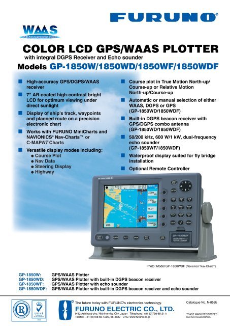
<strong>COLOR</strong> <strong>LCD</strong> <strong>GPS</strong>/<strong>WAAS</strong> <strong>PLOTTER</strong><br />
with integral D<strong>GPS</strong> Receiver and Echo sounder<br />
Models GP-1850W/1850WD/1850WF/1850WDF<br />
■<br />
■<br />
■<br />
■<br />
■<br />
High-accuracy <strong>GPS</strong>/D<strong>GPS</strong>/<strong>WAAS</strong><br />
receiver<br />
7" AR-coated high-contrast bright<br />
<strong>LCD</strong> for optimum viewing under<br />
direct sunlight<br />
Display of ship's track, waypoints<br />
and planned route on a precision<br />
electronic chart<br />
Works with FURUNO MiniCharts and<br />
NAVIONICS ® Nav-Charts or<br />
C-MAPNT Charts<br />
Versatile display modes including:<br />
● Course Plot<br />
● Nav Data<br />
● Steering Display<br />
● Highway<br />
■<br />
■<br />
■<br />
■<br />
■<br />
■<br />
Course plot in True Motion North-up/<br />
Course-up or Relative Motion<br />
North-up/Course-up<br />
Automatic or manual selection of either<br />
<strong>WAAS</strong>, D<strong>GPS</strong> or <strong>GPS</strong><br />
(GP-1850WD/1850WDF)<br />
Built-in D<strong>GPS</strong> beacon receiver with<br />
<strong>GPS</strong>/D<strong>GPS</strong> combo antenna<br />
(GP-1850WD/1850WDF)<br />
50/200 kHz, 600 W/1 kW, dual-frequency<br />
echo sounder<br />
(GP-1850WF/1850WDF)<br />
Waterproof display suited for fly bridge<br />
installation<br />
Optional Remote Controller<br />
Photo: Model GP-1850WDF (Navionics ® Nav-Chart)<br />
GP-1850W:<br />
GP-1850WD:<br />
GP-1850WF:<br />
GP-1850WDF:<br />
<strong>GPS</strong>/<strong>WAAS</strong> Plotter<br />
<strong>GPS</strong>/<strong>WAAS</strong> Plotter with built-in D<strong>GPS</strong> beacon receiver<br />
<strong>GPS</strong>/<strong>WAAS</strong> Plotter with echo sounder<br />
<strong>GPS</strong>/<strong>WAAS</strong> Plotter with built-in D<strong>GPS</strong> beacon receiver and echo sounder<br />
R<br />
The future today with FURUNO's electronics technology.<br />
FURUNO ELECTRIC CO., LTD.<br />
9-52 Ashihara-cho, Nishinomiya City, Japan Telephone: +81 (0)798 65-2111<br />
Telefax: +81 (0)798 65-4200, 66-4622 URL: www.furuno.co.jp<br />
Catalogue No. N-853b<br />
TRADE MARK REGISTERED<br />
MARCA REGISTRADA
Highly Accurate Positioning with <strong>WAAS</strong><br />
High Contrast Bright <strong>LCD</strong><br />
meeting all boaters<br />
demands<br />
<strong>GPS</strong>/D<strong>GPS</strong>/<strong>WAAS</strong><br />
combo antenna<br />
Compact sensitive<br />
<strong>GPS</strong>/<strong>WAAS</strong> antenna<br />
Harbor<br />
Own ship<br />
Planned route<br />
Depth contours<br />
Own ship's<br />
track<br />
Navionics ® Nav-Chart<br />
Remote controller<br />
(option)<br />
Choose from two units<br />
that accept either Furuno<br />
MiniCharts and<br />
Navionics ® Nav-Chart<br />
or C-MAPNT Charts.<br />
<strong>WAAS</strong> (Wide Area Augmentation System)<br />
<strong>WAAS</strong> is a <strong>GPS</strong> navigation system with differential correction by means of<br />
geostationary satellites. The US FAA has been testing this system and expects more<br />
field tests in 2003. Similar systems, using Satellite-Based Augmentation Systems<br />
(SBAS), are under development in Japan (MSAS: MSAT Satellite-based<br />
Augmentation System) and Europe (EGNOS: European Geostationary Navigation<br />
Overlay System). They are said to be fully interoperable and compatible. MSAS and<br />
EGNOS are expected to become fully operational in 2004 or after.<br />
As the <strong>WAAS</strong> utilizes the same frequency as the <strong>GPS</strong>, a single antenna can receive <strong>GPS</strong> and <strong>WAAS</strong> signals. Currently<br />
two Inmarsat GEO satellites are available for receiving the <strong>WAAS</strong> signal: AOR-W and POR. Major contributors of an<br />
error in a single frequency <strong>GPS</strong> system are receiver clock drift and signal delays by refraction. The <strong>WAAS</strong> reference<br />
stations on the earth monitor the <strong>GPS</strong> constellation and route <strong>GPS</strong> error data to the satellites via the master earth<br />
station. The Inmarsat or communication satellite broadcasts the differential corrections to marine and aviation users.
The GP-1850W series are <strong>GPS</strong>/D<strong>GPS</strong>/<strong>WAAS</strong> plotters<br />
with video plotting and echo sounding capability<br />
designed for pleasure craft and coastal fishing boats.<br />
This compact and cost-effective series offers extremely<br />
accurate position fixes - 10 m for the basic <strong>GPS</strong>, 3 m<br />
where <strong>WAAS</strong> service is available and 5 m with D<strong>GPS</strong><br />
(D<strong>GPS</strong> version).<br />
The Display modes include Course Plot, Nav Data,<br />
Steering and Highway. The Steering mode provides an<br />
intuitive indication of course to steer and cross-trackerror.<br />
The Highway mode is useful when you are<br />
following a series of waypoints along a planned route.<br />
The GP-1850WF and GP-1850WDF with the 50/200<br />
kHz echo sounder module present detailed information<br />
on fish and bottom. The echo sounder data can be<br />
displayed jointly with course plot or alone on the full<br />
size screen.<br />
The useable chart cards are Furuno MiniChart/<br />
Navionics ® Nav-Chart or C-MAPNT Chart cards.<br />
Chart cards contain accurate spot sounding, coastlines,<br />
depth contours, buoys, lighthouses and other<br />
navigational features.<br />
Primary Display Modes<br />
Course Plot<br />
C-MAPNT Chart<br />
Choice of TM North-up or<br />
Course-up and RM North-up<br />
or Course-up mode.<br />
Steering Mode<br />
Helps you keep your vessel on<br />
its intended course.<br />
Nav Data<br />
Important navigational<br />
information can be clearly read<br />
from a distance.<br />
Highway<br />
Useful for following legs along<br />
your planned route.<br />
TM Course-up Mode<br />
(Automatic)<br />
In the Auto Courseup<br />
mode, automatic<br />
resetting takes<br />
place at a course<br />
change of 22.5° and<br />
the vessel's<br />
intended course is<br />
kept at the screen<br />
top like a head-up<br />
display.<br />
C-MAP NT Chart<br />
TM North-up Mode<br />
Presentation Modes in Course Plot Display<br />
Four chart orientations are available in the course plot display:<br />
True Motion North-up, Relative Motion North-up, Course-up and<br />
and Auto Course-up modes. In the True Motion modes,<br />
coastlines remain stationary on the screen while your vessel<br />
moves according to its actual speed and course. In the Relative<br />
Motion mode, your vessel is kept at the screen center and<br />
coastlines move relative to your vessel.<br />
The course plot display shows your vessel's position with a<br />
motion trend vector, route, position, speed and course. Your<br />
vessel's heading and speed are<br />
indicated by a vector at your<br />
present position. Display colors<br />
can be changed for optimum<br />
visibility depending on ambient<br />
light conditions.<br />
C-MAPNT Chart<br />
C-MAPNT Chart<br />
RM North-up Mode<br />
Echo Sounder Display (GP-1850WF/1850WDF)<br />
Incorporating a powerful 50/200 kHz, 600 W echo<br />
sounder module, the GP-1850WF/1850WDF present<br />
an echogram in addition to the course plot display.<br />
Full-screen echo sounding modes include Normal<br />
(single- or dual-freq), Bottom-lock, Bottom Zoom,<br />
Marker Zoom and A-scope. Selection of sounding<br />
range, phasing, gain, display mode, frequency and<br />
other settings are simple with the softkeys at the<br />
right of the screen. A water temperature graph can<br />
be displayed if an appropriate temperature sensor<br />
is provided.<br />
C-MAPNT Chart<br />
Course plot + Sounder<br />
Dual frequency<br />
A-scope (at right)
SPECIFICATIONS OF GP-1850W/1850WD/1850WF/1850WDF<br />
<strong>GPS</strong> RECEIVER CHARACTERISTICS<br />
1. Receiver Type Twelve discrete channels, C/A code,<br />
all-in-view, Integral <strong>WAAS</strong> receiver processor<br />
2. Receive Frequency L1 (1575.42 MHz)<br />
3. Accuracy <strong>GPS</strong>: 10 m (95%)<br />
D<strong>GPS</strong>: 5 m (95%)<br />
<strong>WAAS</strong>: 3 m (95%)<br />
4. Time to First Fix 12 seconds typical (Warm start)<br />
5. Tracking Velocity 999 kts<br />
6. Geodetic System WGS-84, NAD-27, and others<br />
7. D<strong>GPS</strong> Capability<br />
GP-1850WD/1850WDF: D<strong>GPS</strong> beacon receiver built in<br />
GP-1850W/1850WF: External D<strong>GPS</strong> beacon receiver transmitting<br />
data in RTCM SC104 v.2.1 format through<br />
RS-232 interface or optional internal D<strong>GPS</strong><br />
beacon receiver<br />
<strong>PLOTTER</strong> CHARACTERISTICS<br />
1. Display 7 inch color <strong>LCD</strong>, 320 x 234 pixels<br />
2. Map Scale 0.125 to 2,048 nm<br />
3. Latitude Limits Between 85°N and 85°S<br />
4. Plot Interval 1 s to 99 min 59 s or 0.01 to 9.99 nm<br />
5. Display Modes Course plot, Nav Data, Steering Display,<br />
Highway<br />
6. Presentation Modes TM/RM North-up, Course-up<br />
7. Memory Capacity Up to 5,000 points for ship's track points and<br />
marks.<br />
800 waypoints and 200 planned routes<br />
(Max. 35 waypoints/route)<br />
8. Voyage Planning Waypoint navigation or route navigation<br />
9. Alarms Arrival/anchor watch, XTE, proximity alert,<br />
ship speed, depth*, water temperature*, fish*<br />
*GP-1850WF/1850WDF —Temperature sensor required for water temp alarm.<br />
10. Interface (NMEA 0183 ver. 1.5/2.0)<br />
Outputs:<br />
AAM, APB, BOD, BWC, GGA, GLL, RMA, RMB, RMC, VTG, WPL,<br />
XTE, ZDA, DBT*, DPT*, MTW*, MSK<br />
Inputs:<br />
DBT*, DPT*, MTW*, TLL, YMWPL (YEOMAN wpt data)<br />
*GP-1850WF/1850WDF<br />
11. Electronic Chart FURUNO MiniChart and<br />
NAVIONICS ® Nav-Chart or<br />
C-MAPNT Chart<br />
<strong>GPS</strong> ANTENNA<br />
GPA-017 0.15 kg 0.3 lb<br />
69 2.7"<br />
24 0.9"<br />
61 2.4"<br />
D<strong>GPS</strong> ANTENNA<br />
GPA-019 1.0 kg 2.2 lb<br />
156 6.1"<br />
116 4.6"<br />
ECHO SOUNDER<br />
1. Display Modes Normal (single- or dual-frequency), Bottom-lock,<br />
Bottom Zoom, Marker Zoom, A-scope<br />
2. Frequency 50 and 200 kHz<br />
3. Output Power 600 W/1 kW (specify when ordering)<br />
4. Basic Ranges 8 basic ranges customized to max 1200 m<br />
(4000 ft, 650 fa)<br />
5. Range Phasing Up to 2400 m (8000 ft, 1300 fa)<br />
ENVIRONMENTAL CONDITIONS (IEC 60945 testing)<br />
1. Temperature<br />
Display Unit: -15°C to +55°C<br />
Antenna Unit: -25°C to +70°C<br />
2. Waterproofing<br />
Display Unit: IPX5 (IEC 60529), CFR46 (USCG)<br />
Antenna Unit: IPX6 (IEC 60529), CFR46 (USCG)<br />
POWER SUPPLY<br />
12 - 24 VDC, GP-1850W: 17 W, GP-1850WD: 19 W, GP-1850WF: 31 W,<br />
GP-1850WDF: 33 W<br />
EQUIPMENT LIST<br />
Standard<br />
1. Display Unit 1 unit<br />
2. Antenna Unit with10 m cable 1 unit<br />
3. NMEA Cable 5 m 1 pc<br />
4. Installation Materials and Standard Spare PParts 1 set<br />
Option<br />
1. FURUNO MiniChart Card<br />
2. Remote Controller<br />
3. NMEA Cable 10 m<br />
4. Antenna Mounting Base<br />
13-QA330 (Pipe mount), 13-QA310 (Offset bracket), 13-RC5160 (Handrail mount)<br />
5. Rectifier PR-62 for 115/230 VAC mains<br />
6. Temperature Sensor T-02MTB/T-02MSB/T-03MSB (GP-1850WF/GP-<br />
1850WDF)<br />
7. Speed/Temperature Sensor ST-02MSB/ST-02PSB (GP-1850WF/GP-<br />
1850WDF)<br />
8. Internal D<strong>GPS</strong> Beacon Receiver Kit for GP-1850W/GP-1850WF<br />
Transducers (Specify when ordering GP-1850WF/1850WDF)<br />
600 W<br />
520-5PSD (Plastic thru-hull), 520-5MSD (Bronze thru-hull),<br />
520-5PWD (Plastic transom), 525ST-MSD (Bronze thru-hull w/speed/temp sensor)<br />
525ST-PWD (Plastic transom w/speed/temp sensor)<br />
1 kW<br />
50/200-1T (Optional matching box required)<br />
INTERCONNECTION DIAGRAM<br />
Antenna unit GPA-017<br />
(For GP-1850W/GP-1850WF)<br />
Antenna Unit GPA-019<br />
(For GP-1850WD/GP-1850WDF)<br />
32 1.3"<br />
DISPLAY UNIT<br />
259 10.2"<br />
4- 6<br />
87<br />
3.4"<br />
GP-1850W: 3.0 kg, 6.6 lb<br />
GP-1850WD: 3.2 kg, 7.1 lb<br />
GP-1850WF: 3.3 kg, 7.3 lb<br />
GP-1850WDF: 3.4 kg, 7.5 lb<br />
GGA,<br />
GLL, etc.<br />
NMEA in/out<br />
Optional<br />
Antenna Base<br />
10 m<br />
Display Unit<br />
Optional<br />
Antenna Base<br />
10 m<br />
D<strong>GPS</strong><br />
Beacon Receiver<br />
(GP-1850W/GP-1850WF)<br />
190 7.5"<br />
286 11.3"<br />
260 10.2"<br />
165 6.5"<br />
18<br />
0.7"<br />
MAX203 8.0"<br />
30<br />
31<br />
1.2" 131 5.2"<br />
30 1.2"<br />
Rectifier<br />
PR-62<br />
115/230 VAC<br />
Option<br />
12 to 24 VDC<br />
Transducer<br />
(For GP-1850WF/GP-1850WDF)<br />
(Specify when ordering)<br />
Temperature Sensor<br />
T-02MTB/T-03MSB<br />
or<br />
Speed/Temperature Sensor<br />
ST-02MSB/ST-02PSB<br />
(GP-1850WF/GP-1850WDF)<br />
FURUNO U.S.A., INC.<br />
Camas, Washington, U.S.A.<br />
Phone: +1 360-834-9300 Telefax: +1 360-834-9400<br />
FURUNO (UK) LIMITED<br />
Denmead, Hampshire, U.K.<br />
Phone: +44 2392-230303 Telefax: +44 2392-230101<br />
FURUNO FRANCE S.A.<br />
Bordeaux-Mérignac, France<br />
Phone: +33 05 56 13 48 00 Telefax: +33 05 56 13 48 01<br />
FURUNO ESPAÑA S.A.<br />
Madrid, Spain<br />
Phone: +34 91-725-90-88 Telefax: +34 91-725-98-97<br />
FURUNO DANMARK AS<br />
Hvidovre, Denmark<br />
Phone: +45 36 77 45 00 Telefax: +45 36 77 45 01<br />
FURUNO NORGE A/S<br />
Ålesund, Norway<br />
Phone: +47 70 102950 Telefax: +47 70 127021<br />
FURUNO SVERIGE AB<br />
Västra Frölunda, Sweden<br />
Phone: +46 31-7098940 Telefax: +46 31-497093<br />
FURUNO FINLAND OY<br />
Espoo, Finland<br />
Phone: +358 9 4355 670 Telefax: +358 9 4355 6710<br />
SPECIFICATIONS SUBJECT TO CHANGE WITHOUT NOTICE<br />
03105SS Printed in Japan