

Groundwater management in a coastal aquifer ... - India Water Portal
Groundwater management in a coastal aquifer ... - India Water Portal
Groundwater management in a coastal aquifer ... - India Water Portal

You also want an ePaper? Increase the reach of your titles
YUMPU automatically turns print PDFs into web optimized ePapers that Google loves.
RESEARCH ARTICLES<br />
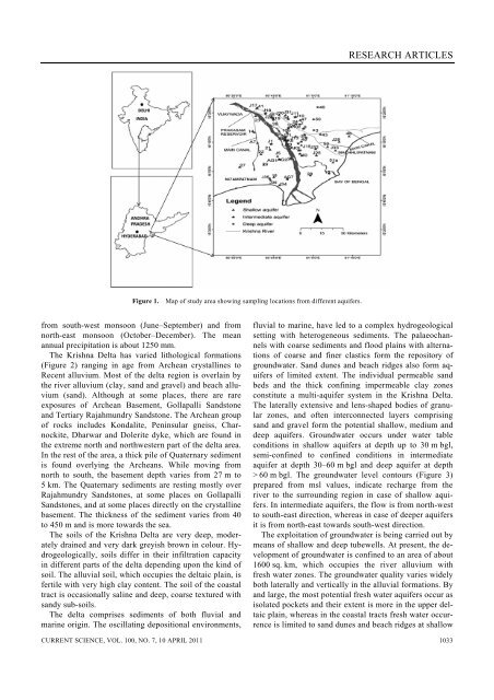
Figure 1. Map of study area show<strong>in</strong>g sampl<strong>in</strong>g locations from different <strong>aquifer</strong>s.<br />
from south-west monsoon (June–September) and from<br />
north-east monsoon (October–December). The mean<br />
annual precipitation is about 1250 mm.<br />
The Krishna Delta has varied lithological formations<br />
(Figure 2) rang<strong>in</strong>g <strong>in</strong> age from Archean crystall<strong>in</strong>es to<br />
Recent alluvium. Most of the delta region is overla<strong>in</strong> by<br />
the river alluvium (clay, sand and gravel) and beach alluvium<br />
(sand). Although at some places, there are rare<br />
exposures of Archean Basement, Gollapalli Sandstone<br />
and Tertiary Rajahmundry Sandstone. The Archean group<br />
of rocks <strong>in</strong>cludes Kondalite, Pen<strong>in</strong>sular gneiss, Charnockite,<br />
Dharwar and Dolerite dyke, which are found <strong>in</strong><br />
the extreme north and northwestern part of the delta area.<br />
In the rest of the area, a thick pile of Quaternary sediment<br />
is found overly<strong>in</strong>g the Archeans. While mov<strong>in</strong>g from<br />
north to south, the basement depth varies from 27 m to<br />
5 km. The Quaternary sediments are rest<strong>in</strong>g mostly over<br />
Rajahmundry Sandstones, at some places on Gollapalli<br />
Sandstones, and at some places directly on the crystall<strong>in</strong>e<br />
basement. The thickness of the sediment varies from 40<br />
to 450 m and is more towards the sea.<br />
The soils of the Krishna Delta are very deep, moderately<br />
dra<strong>in</strong>ed and very dark greyish brown <strong>in</strong> colour. Hydrogeologically,<br />
soils differ <strong>in</strong> their <strong>in</strong>filtration capacity<br />
<strong>in</strong> different parts of the delta depend<strong>in</strong>g upon the k<strong>in</strong>d of<br />
soil. The alluvial soil, which occupies the deltaic pla<strong>in</strong>, is<br />
fertile with very high clay content. The soil of the <strong>coastal</strong><br />
tract is occasionally sal<strong>in</strong>e and deep, coarse textured with<br />
sandy sub-soils.<br />
The delta comprises sediments of both fluvial and<br />
mar<strong>in</strong>e orig<strong>in</strong>. The oscillat<strong>in</strong>g depositional environments,<br />
fluvial to mar<strong>in</strong>e, have led to a complex hydrogeological<br />
sett<strong>in</strong>g with heterogeneous sediments. The palaeochannels<br />
with coarse sediments and flood pla<strong>in</strong>s with alternations<br />
of coarse and f<strong>in</strong>er clastics form the repository of<br />
groundwater. Sand dunes and beach ridges also form <strong>aquifer</strong>s<br />
of limited extent. The <strong>in</strong>dividual permeable sand<br />
beds and the thick conf<strong>in</strong><strong>in</strong>g impermeable clay zones<br />
constitute a multi-<strong>aquifer</strong> system <strong>in</strong> the Krishna Delta.<br />
The laterally extensive and lens-shaped bodies of granular<br />
zones, and often <strong>in</strong>terconnected layers compris<strong>in</strong>g<br />
sand and gravel form the potential shallow, medium and<br />
deep <strong>aquifer</strong>s. <strong>Groundwater</strong> occurs under water table<br />
conditions <strong>in</strong> shallow <strong>aquifer</strong>s at depth up to 30 m bgl,<br />
semi-conf<strong>in</strong>ed to conf<strong>in</strong>ed conditions <strong>in</strong> <strong>in</strong>termediate<br />
<strong>aquifer</strong> at depth 30–60 m bgl and deep <strong>aquifer</strong> at depth<br />
> 60 m bgl. The groundwater level contours (Figure 3)<br />
prepared from msl values, <strong>in</strong>dicate recharge from the<br />
river to the surround<strong>in</strong>g region <strong>in</strong> case of shallow <strong>aquifer</strong>s.<br />
In <strong>in</strong>termediate <strong>aquifer</strong>s, the flow is from north-west<br />
to south-east direction, whereas <strong>in</strong> case of deeper <strong>aquifer</strong>s<br />
it is from north-east towards south-west direction.<br />
The exploitation of groundwater is be<strong>in</strong>g carried out by<br />
means of shallow and deep tubewells. At present, the development<br />
of groundwater is conf<strong>in</strong>ed to an area of about<br />
1600 sq. km, which occupies the river alluvium with<br />
fresh water zones. The groundwater quality varies widely<br />
both laterally and vertically <strong>in</strong> the alluvial formations. By<br />
and large, the most potential fresh water <strong>aquifer</strong>s occur as<br />
isolated pockets and their extent is more <strong>in</strong> the upper deltaic<br />
pla<strong>in</strong>, whereas <strong>in</strong> the <strong>coastal</strong> tracts fresh water occurrence<br />
is limited to sand dunes and beach ridges at shallow<br />
CURRENT SCIENCE, VOL. 100, NO. 7, 10 APRIL 2011 1033


