Partitioning 3D Surface Meshes Using Watershed Segmentation
Partitioning 3D Surface Meshes Using Watershed Segmentation
Partitioning 3D Surface Meshes Using Watershed Segmentation

You also want an ePaper? Increase the reach of your titles
YUMPU automatically turns print PDFs into web optimized ePapers that Google loves.
312 IEEE TRANSACTIONS ON VISUALIZATION AND COMPUTER GRAPHICS, VOL. 5, NO. 4, OCTOBER-DECEMBER 1999<br />
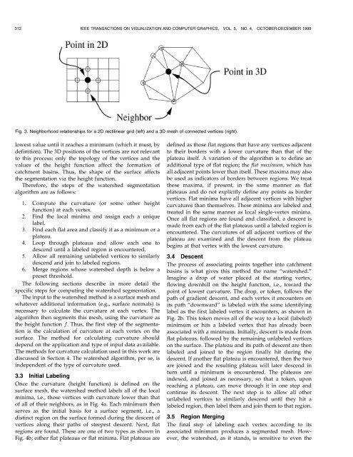
Fig. 3. Neighborhood relationships for a 2D rectilinear grid (left) and a <strong>3D</strong> mesh of connected vertices (right).<br />
lowest value until it reaches a minimum (which it must, by<br />
definition). The <strong>3D</strong> positions of the vertices are not relevant<br />
to this process; only the topology of the vertices and the<br />
values of the height function affect the formation of<br />
catchment basins. Thus, the shape of the surface affects<br />
the segmentation via the height function.<br />
Therefore, the steps of the watershed segmentation<br />
algorithm are as follows:<br />
1. Compute the curvature (or some other height<br />
function) at each vertex.<br />
2. Find the local minima and assign each a unique<br />
label.<br />
3. Find each flat area and classify it as a minimum or a<br />
plateau.<br />
4. Loop through plateaus and allow each one to<br />
descend until a labeled region is encountered.<br />
5. Allow all remaining unlabeled vertices to similarly<br />
descend and join to labeled regions.<br />
6. Merge regions whose watershed depth is below a<br />
preset threshold.<br />
The following sections describe in more detail the<br />
specific steps for computing the watershed segmentation.<br />
The input to the watershed method is a surface mesh and<br />
whatever additional information (e.g., surface normals) is<br />
necessary to calculate the curvature at each vertex. The<br />
algorithm then segments this mesh, using the curvature as<br />
the height function f. Thus, the first step of the segmentation<br />
is the calculation of curvature at each vertex on the<br />
surface. The method for calculating curvature should<br />
depend on the application and type of input data available.<br />
The methods for curvature calculation used in this work are<br />
discussed in Section 4. The watershed algorithm, per se, is<br />
independent of the type of curvature used.<br />
3.3 Initial Labeling<br />
Once the curvature (height function) is defined on the<br />
surface mesh, the watershed method labels all of the local<br />
minima, i.e., those vertices with curvature lower than that<br />
of all of their neighbors, as in Fig. 4a. Each minimum then<br />
serves as the initial basis for a surface segment, i.e., a<br />
distinct region on the surface formed during the descent of<br />
vertices along their paths of steepest descent. Next, flat<br />
regions are found. These are one of two types as shown in<br />
Fig. 4b; either flat plateaus or flat minima. Flat plateaus are<br />
defined as those flat regions that have any vertices adjacent<br />
to their borders with a lower curvature than that of the<br />
plateau itself. A variation of the algorithm is to define an<br />
additional type of flat region; the flat maximum, which has<br />
all adjacent points lower than itself. These maxima may also<br />
be used as indicators of borders between regions. We treat<br />
these maxima, if present, in the same manner as flat<br />
plateaus and do not explicitly define any points as border<br />
vertices. Flat minima have all adjacent vertices with higher<br />
curvatures than themselves. These minima are labeled and<br />
treated in the same manner as local single-vertex minima.<br />
Once all flat regions are found and classified, a descent is<br />
made from each of the flat plateaus until a labeled region is<br />
encountered. The curvatures of all adjacent vertices of the<br />
plateau are examined and the descent from the plateau<br />
begins at that vertex with the lowest curvature.<br />
3.4 Descent<br />
The process of associating points together into catchment<br />
basins is what gives this method the name ªwatershed.º<br />
Imagine a drop of water placed at the starting vertex,<br />
flowing downhill on the height function, i.e., toward the<br />
point of lowest curvature. The drop, or token, follows the<br />
path of gradient descent, and each vertex it encounters on<br />
its path ªdownwardº is labeled with the same identifying<br />
label as the first labeled vertex it encounters, as shown in<br />
Fig. 2b. This token moves all of the way to a local (labeled)<br />
minimum or hits a labeled vertex that has already been<br />
associated with a minimum. Initially, descent is made from<br />
flat plateaus, followed by the remaining unlabeled vertices<br />
on the surface. The plateau and its path of descent are then<br />
labeled and joined to the region finally hit during the<br />
descent. If another flat plateau is encountered, then the two<br />
are joined and the resulting plateau will later descend in<br />
turn until a minimum is encountered. The plateaus are<br />
indexed, and joined as necessary, so that a token, upon<br />
reaching a plateau, can move through it in one step and<br />
continue its descent. The next step is to allow all other<br />
unlabeled vertices to similarly descend until they hit a<br />
labeled region, then label them and join them to that region.<br />
3.5 Region Merging<br />
The final step of labeling each vertex according to its<br />
associated minimum produces a segmented mesh. However,<br />
the watershed, as it stands, is sensitive to even the