Key Issues Paper - Carlisle City Council
Key Issues Paper - Carlisle City Council
Key Issues Paper - Carlisle City Council

You also want an ePaper? Increase the reach of your titles
YUMPU automatically turns print PDFs into web optimized ePapers that Google loves.
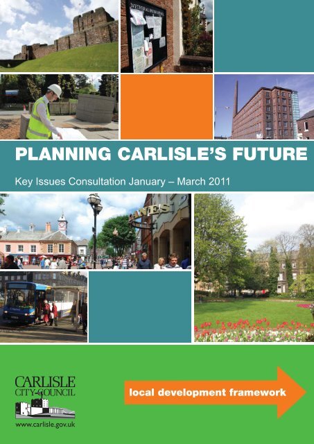
PLANNING CARLISLE’S FUTURE<br />
<strong>Key</strong> <strong>Issues</strong> Consultation January – March 2011<br />
local development framework<br />
Page i
This document is part of the Local Development<br />
Framework, produced by the Planning Service of<br />
<strong>Carlisle</strong> <strong>City</strong> <strong>Council</strong>. If you would like this document in<br />
another format, for example large print, braille, audio<br />
tape or another language, please contact:<br />
Planning Services<br />
<strong>Carlisle</strong> <strong>City</strong> <strong>Council</strong><br />
Civic Centre<br />
<strong>Carlisle</strong><br />
Cumbria<br />
CA3 8QG<br />
email: lpc@carlisle.gov.uk<br />
Tel: 01228 817193<br />
Page ii
Contents<br />
1. Chapter 1 - Introduction ........................................................................ 1<br />
2. Chapter 2 - Spatial Portrait .................................................................. 5<br />
3. Chapter 3 - Evidence Base ................................................................... 9<br />
4. Chapter 4 - Characteristics of the Main Settlements ............... 17<br />
5. Chapter 5 - Scope of the Core Strategy ......................................... 25<br />
Appendix 1 .................................................................................................... 27<br />
Page iii
Page iv
Chapter 1 Introduction<br />
1.1 This <strong>Issues</strong> paper is the fi rst stage in the process of developing the planning framework for<br />
the District. It sets out the <strong>Council</strong>’s initial thinking on the issues that the Core Strategy should<br />
address. This <strong>Issues</strong> <strong>Paper</strong> provides you with an opportunity to share your views on the<br />
issues and challenges facing the District and the priorities to be tackled.<br />
1.2 The <strong>Carlisle</strong> Local Development Framework (LDF) is a portfolio of documents being produced<br />
by <strong>Carlisle</strong> <strong>City</strong> <strong>Council</strong>, which will in time replace the policies of the existing Local Plan to<br />
provide the spatial planning strategy for the District.<br />
1.3 Work on the LDF has so far focussed on developing a robust evidence base to support and<br />
assist in determining the best approach to establishing the desired future of <strong>Carlisle</strong>.<br />
1.4 The Core Strategy is the principal document of the <strong>Carlisle</strong> Local Development Framework,<br />
guiding the future development and growth in the District up to 2030. It will address key<br />
questions such as the amount and location of land for a range of different land uses including<br />
housing and employment uses.<br />
1.5 The Core Strategy, when fi nalised will include the following:<br />
• An overall spatial vision, which sets out how the District should develop;<br />
• Strategic objectives for the District, focusing on the key issues to be addressed;<br />
• A delivery strategy for achieving these objectives; this will set out how much development is<br />
intended to happen where, when and how it will be delivered<br />
• Core policies to set the basis for determining planning applications;<br />
• Strategic locations for development<br />
1.6 The preparation of the Core strategy consists of a number of different stages:<br />
• Preparation/collation of the evidence base<br />
• <strong>Key</strong> issues consultation<br />
• Feedback and formulation of options<br />
• <strong>Issues</strong> and options consultation<br />
• Preferred options consultation<br />
• Feedback and preparation of Submission Draft<br />
• Submission to SoS<br />
• Examination<br />
• Adoption of the Core Strategy<br />
Page 1
Figure 1 - <strong>Key</strong> Stages in Core |Strategy Process<br />
Evidence gathering and preparation of issues<br />
<strong>Key</strong> <strong>Issues</strong> <strong>Paper</strong> public consultation (6 weeks)<br />
<strong>Issues</strong> and Options <strong>Paper</strong> public consulation (6 weeks)<br />
Collate consultation responses to feed into the <strong>Issues</strong> and Options <strong>Paper</strong><br />
Public consultation of the Preferred Options <strong>Paper</strong> (6 weeks)<br />
Collate consultation responses to inform preferred options<br />
Collate consultation responses<br />
Publication of Draft Core Strategy<br />
Submission to Secretary of State<br />
Stage we are currently at<br />
Stage 1 Stage 2 Stage 3<br />
Independent examination<br />
Stage 4 Stage 5 Stage 6<br />
Adoption of the Core Strategy<br />
This diagram highlights the stage that we are currently in the development of <strong>Carlisle</strong>’s Core Strategy and shows that there will be<br />
numerous opportunities for the public to get involved and make representations in the near future.<br />
Page 2
1.7 Once the Core strategy has been through all the relevant stages it will be adopted by<br />
<strong>Carlisle</strong> <strong>City</strong> <strong>Council</strong> and form the overarching planning policy framework for the District and<br />
along with other development plan documents will provide the basis for determining planning<br />
applications.<br />
Next Steps<br />
1.8 This paper identifi es our fi rst thoughts on the main issues that the Core Strategy needs to<br />
address. We are asking you to provide views on these issues or to raise other issues that<br />
we may have missed. In commenting we also welcome your ideas as to how the issues<br />
might be addressed.<br />
1.9 When commenting on the <strong>Issues</strong> please also think about what you like about <strong>Carlisle</strong>, the<br />
qualities of the existing environment and infrastructure and the implications of population<br />
growth and development.<br />
1.10 The next stage in the preparation of the Core Strategy is the <strong>Issues</strong> and Options<br />
consultation. We will use the responses to this consultation to help formulate options. The<br />
<strong>Issues</strong> and Options consultation is programme to commence in August 2011.<br />
How can you get involved<br />
The period of consultation on the <strong>Key</strong> <strong>Issues</strong> paper will run from 31st January until 31st March<br />
2011.<br />
The document will be available to view on the <strong>Council</strong>’s website at www.carlisle.gov.uk.<br />
Comments can be submitted online via our website, emailed to us at lpc@carlisle.gov.uk<br />
or posted to Planning Policy & Conservation, <strong>Carlisle</strong> <strong>City</strong> <strong>Council</strong>, Civic Centre,<br />
<strong>Carlisle</strong>, Cumbria, CA3 8QG.<br />
Hard copies of the <strong>Key</strong> <strong>Issues</strong> <strong>Paper</strong> will be available to view in all local libraries and at the Civic<br />
Centre Customer Contact Centre or on request.<br />
For any general queries relating to this document please contact the Planning Policy Team<br />
Tel: 01228 817193.<br />
Page 3
Page 4
Chapter 2 Spatial Portrait<br />
Figure 2<br />
2.1 This spatial portrait aims to describe the District’s geography, environment, economy, social<br />
and cultural characteristics and movement patterns i.e. a snapshot of the District as it is now. It<br />
also highlights the key issues associated with the District as a whole.<br />
2.2 <strong>Carlisle</strong>’s identity is largely shaped by its extensive rural hinterland with an important<br />
agricultural economy, its setting in an area of high landscape value, the historic core of the city<br />
traversed by rivers that are internationally important for biodiversity, and a World Heritage Site<br />
which strides across the district.<br />
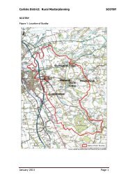
2.3 The District of <strong>Carlisle</strong> covers an area of approximately 1,042 sq km and is situated to the far<br />
north of the Cumbrian County, bounded by the Scottish border, approximately 9 miles to the<br />
northwest. The <strong>City</strong> of <strong>Carlisle</strong> and its surrounds, form the principal urban area to the southeast<br />
of the District. The remainder of the District is predominantly rural in nature, with the exception<br />
of the <strong>Key</strong> Service Centres of Longtown to the north and Brampton to the east.<br />
Social Characteristics<br />
2.4 The population of <strong>Carlisle</strong> is currently estimated at 104,700. It has experienced a steady growth<br />
rate over the last 10 years; however recent forecasts show a slow down due to a decrease<br />
in inward migration. In line with national trends growth in <strong>Carlisle</strong> will most notably be seen in<br />
the number of older people living in the District where it is predicted that there will be a 57%<br />
increase by 2032. Approximately 68 per cent of the population currently live within the urban<br />
area of <strong>Carlisle</strong>. In the rural areas a key feature is the sparse distribution of residents; on<br />
average there are 97 people per hectare in <strong>Carlisle</strong>’s rural areas (compared to 477 regionally<br />
and 378 nationally).<br />
Page 5
Movement Patterns<br />
2.5 The M6 motorway runs through the District linking the <strong>City</strong> of <strong>Carlisle</strong> to southwest Scotland,<br />
Northwest England and beyond. <strong>Carlisle</strong> benefi ts from three M6 junctions at Carleton (J42),<br />
Rosehill (J43) and Kingstown (J44). Despite this some urban areas to the south west of the<br />
<strong>City</strong> are currently relatively isolated largely due to the barrier presented by the River Eden.<br />
The <strong>Carlisle</strong> North Development Route (CNDR), which is due for completion in 2012, will help<br />
to open up these areas by providing a western link to the M6 at junction 44.<br />
2.6 In terms of rail travel, the West Coast Main line provides the only north/south high speed rail<br />
link serving the <strong>City</strong>. However, there are rail links to Newcastle and the west coast and also<br />
the largely tourist based <strong>Carlisle</strong>/Settle line.<br />
2.7 Travel to work is heavily dependant on private car usage with 54.3 % people working in<br />
<strong>Carlisle</strong> District choosing to drive to work (source ONS Census 2001) despite the fact that<br />
nearly 55% of people travel less than 5km to their place of work. This level of car usage<br />
is no doubt partly due to accessibility to public transport across the District which varies<br />
considerably outside the urban area, with a number of areas having a very limited service or<br />
no service at all.<br />
Economy<br />
2.8 <strong>Carlisle</strong> is a free standing city which is not directly infl uenced by a major conurbation. It acts<br />
as a signifi cant employment base for Cumbria as well as parts of south west Scotland.<br />
2.9 Historically the economy of <strong>Carlisle</strong> was based around the textile industry which has over time<br />
declined and been replaced by other forms of manufacturing. A large proportion of <strong>Carlisle</strong>’s<br />
working population today are still employed in the manufacturing sector however wholesale/<br />
retail provide employment for the largest proportion of the workforce. Employment in nonservice<br />
industries, such as agriculture, manufacturing and construction are all higher than the<br />
national average.<br />
2.10 Within the rural area Brampton and Longtown act as employment hubs along with Dalston<br />
to a lesser extent. All three settlements have industrial estates which provide employment<br />
opportunities for people within their locality as well as the wider area.<br />
2.11 Whilst <strong>Carlisle</strong> benefi ts from good connections to the M6 as well as being situated on<br />
the West Coast mainline, there can still be a perception by businesses from outside the<br />
area of remoteness and isolation which may detract from <strong>Carlisle</strong>’s attractiveness as a<br />
business location. This is further compounded by a gap in skills partially as a result of<br />
poor performance in education and low aspirations as well as a poor level of retention of<br />
graduates.<br />
2.12 Tourism is of major importance to <strong>Carlisle</strong> as a generator of economic prosperity and<br />
employment. It is essential that the tourism potential of the District is promoted and<br />
exploited to maximise the benefi ts it can bring to the area. <strong>Carlisle</strong>’s heritage is central to its<br />
attractiveness as a tourist location with Hadrian’s Wall Path National Trail crossing the District<br />
alongside the historic including <strong>Carlisle</strong> Castle, Tullie House Museum, <strong>Carlisle</strong> Cathedral<br />
precinct, the <strong>City</strong> Walls, The Courts, the Market Cross, the Old Town Hall and the Guildhall.<br />
Page 6
The high quality environment in and around <strong>Carlisle</strong> District contributes towards <strong>Carlisle</strong>’s<br />
appeal as a visitor destination and provides potential for economic diversifi cation within the<br />
rural area; opportunities of this nature are already being supported along the route of the<br />
Hadrian’s Wall Path National Trail with the development of accommodation and refreshment<br />
facilities. In recent years it has been recognised that <strong>Carlisle</strong>’s offer lacks the presence of a<br />
professional theatre and high quality hotel which would further enhance its potential as a visitor<br />
destination.<br />
Flooding and Climate Change<br />
2.13 The position of <strong>Carlisle</strong> at the meeting point of three rivers makes it vulnerable to the risk of<br />
fl ooding. In 2005 the District experienced the worst fl oods since 1822 which resulted in the<br />
death of 3 people and severely affected many homes and businesses. Flood Defences have<br />
recently been completed offering a good level of defence against future fl ood risk. However<br />
caution must still be taken when considering proposals for development in the high risk areas<br />
benefi tting from defences.<br />
2.14 Specifi c data for the impacts of climate change on <strong>Carlisle</strong> are not readily available, but<br />
information is available on a regional basis that gives a good indication of the potential<br />
impacts. Between now and 2080 if we continue to discharge high amounts of greenhouse<br />
gases, <strong>Carlisle</strong> <strong>City</strong> <strong>Council</strong> could expect impacts on operations and service delivery including:<br />
• Longer growing seasons would mean changes to grass cutting regimes.<br />
• More extreme weather conditions causing disruption to front line services like<br />
refuse/recycling collections.<br />
• Higher energy costs for buildings and transport as climate change impacts on<br />
markets and trade.<br />
• Health related problems for example waterborne diseases linked to warm weather<br />
impacting on environmental health services.<br />
• Drier summers could lead to droughts affecting parks, allotments and nature<br />
reserves putting pressure on water resources and local biodiversity.<br />
Local Character and Distinctiveness<br />
2.15 <strong>Carlisle</strong> has an attractive and varied landscape. The District includes two Areas of Outstanding<br />
Natural Beauty, (Solway Coast and the North Pennines) as well as four rivers the Eden,<br />
Caldew, Petteril and Lyne. The River Eden and its tributaries are of international importance for<br />
their biodiversity, being designated as both an SAC and an SPA. <strong>Carlisle</strong> has a range of other<br />
sites of European nature conservation importance including 1 Ramsar Site and 7 Special Areas<br />
of Conservation/Special Protection Areas. In addition, the District is home to many rare and<br />
endangered species such as the red squirrel, natterjack toad and otters, as well as habitats<br />
such as peat bogs and upland hay meadows.<br />
2.16 The District has approximately 455 ha of public open space, which ranges from amenity open<br />
space (land which is recognised as making a contribution to the visual amenity and enjoyment<br />
of an area), to natural/semi natural greenspace, parks/gardens, allotments, play areas and<br />
outdoor sports facilities. Within the centre of the city, and located immediately next to the River<br />
Eden are two linked and important urban parks, Rickerby Park and Bitts Park. Rickerby Park is<br />
a natural park dotted with mature trees and grazed by sheep and cattle. Bitts Park has a more<br />
formal layout with fl ower beds, trees and shrubberies, together with playing pitches, children’s<br />
play area and tennis courts etc.<br />
Page 7
Page 8
Chapter 3 Evidence Base<br />
3.1 The District is rich in heritage ranging from Hadrian’s Wall World Heritage site which crosses<br />
the district from Gilsland in the East to Burgh by Sands in the West, to the <strong>City</strong> walls, <strong>Carlisle</strong><br />
Cathedral and Tullie House which are all grade I Listed buildings. In addition to these there<br />
are approximately another 1550 listed buildings and 19 Conservation Areas including areas<br />
within Brampton, Longtown and Dalston as well as some of the smaller villages.<br />
The Core Strategy must be based on a sound evidence base. Evidence is derived from two<br />
different types of source:<br />
• A1 - Existing strategies and policy documents on a national, regional, sub regional and<br />
local scale<br />
• A2 - Factual information about <strong>Carlisle</strong> and the surrounding areas<br />
A1 - Existing Strategies<br />
3.2 The following strategies have been highlighted in this document as being of particular<br />
importance as the Core Strategy is critical in delivering corporate and community aspirations.<br />
The key objectives in existing strategies need therefore to be identifi ed to ensure that the key<br />
spatial planning issues and objectives for the area align and seek to achieve the aspirations.<br />
Corporate Priorities<br />
3.3 <strong>Carlisle</strong> <strong>City</strong> <strong>Council</strong>’s Corporate Priorities are ‘Local Environment and Growing <strong>Carlisle</strong>’s<br />
Economy’.<br />
Sustainable Community Strategy<br />
3.4 The purpose of a sustainable community strategy is to set out the strategic vision for a place<br />
and provides a vehicle for considering and deciding how to address diffi cult cross cutting<br />
issues such as social inequalities, economic growth, climate change and crime.<br />
3.5 <strong>Carlisle</strong>’s sustainable community strategy the ‘<strong>Carlisle</strong> Partnership Community Plan 2011-<br />
2016’ is being produced by <strong>Carlisle</strong>’s Local Strategic Partnership the ‘<strong>Carlisle</strong> Partnership’.<br />
In doing so the partnership seek to identify and work on key issues affecting communities in<br />
both the rural and urban areas including health, housing, education, employment, community<br />
safety, crime reduction and social inclusion.<br />
3.6 The Core Strategy must have regard to the Community Strategy. As noted above the<br />
Community Strategy is currently being refreshed and the Core Strategy will be a key<br />
component in its delivery, setting out its spatial aspects where appropriate and providing a<br />
long-term spatial vision.<br />
Page 9
3.7 The overarching vision of the <strong>Carlisle</strong> Community Plan is set out below:<br />
The <strong>Carlisle</strong> Partnership seeks to improve the general quality of life, environment and<br />
opportunities for people across the district.<br />
We want to ensure that <strong>Carlisle</strong> enjoys a strong and growing economy providing positive and<br />
progressive employment opportunities for local people. We want <strong>Carlisle</strong> to be a healthy city<br />
where people enjoy long, happy and healthy lives and are able to contribute fully and support<br />
<strong>Carlisle</strong>’s growth. We want to continuously raise the aspirations of our young people and<br />
allow them to look forward to a positive future. We want to make sure that <strong>Carlisle</strong> is a safe<br />
place to live where people feel part of their community and are able to influence the decisions<br />
that affect them. We want to ensure that people can access the services that are important to<br />
them and afford decent homes across the district.<br />
We want to reduce the health and socio-economic inequalities that too often exist across<br />
<strong>Carlisle</strong>, narrowing the gaps between best and worst.<br />
Above all we want to realise the strengths of our greatest asset – the people that live here.<br />
<strong>Carlisle</strong> is blessed with resourceful, resilient and responsive people we want to bring them<br />
together into communities that can help shape and deliver their own future.<br />
Above all we want to realise the strengths of our greatest asset – the people that live here. <strong>Carlisle</strong><br />
is blessed with resourceful, resilient and responsive people we want to bring them together into<br />
communities that can help shape and deliver their own future.<br />
3.8 In order to deliver the above vision the strategy includes 4 objectives and aims. These are to:<br />
• Delivering Healthy Communities<br />
<br />
Aim: improve public health across <strong>Carlisle</strong> and reduce health<br />
inequalities within the District.<br />
• Delivering Economic Growth<br />
<br />
Aim: deliver measured economic growth and performance<br />
• Delivering Safer and Stronger Communities<br />
<br />
Aim: maintain <strong>Carlisle</strong> as a safe place to live, work and visit.<br />
• Supporting children and young people<br />
<br />
Aim: raise aspirations and attainment, reduce inequalities<br />
in attainment, and ensure progressive and positive social and<br />
economic opportunities for children and young people.<br />
Page 10
<strong>Carlisle</strong> District Local Plan 2001-2016<br />
3.9 The <strong>Carlisle</strong> District Local Plan was adopted in September 2008. The Local Plan sets out the<br />
current planning policy framework for <strong>Carlisle</strong> District. Whilst this document is relatively young<br />
in planning policy terms when adopted it only had a limited life span due to the changes that<br />
have been made to the development plan system.<br />
The main aims of the sustainable strategy of the Local Plan are:<br />
1. To develop <strong>Carlisle</strong>’s sub-regional role for employment, shopping, leisure and services<br />
without making excessive demands on resources, or being incompatible with the environment<br />
in which we live; and<br />
2. To balance the need for economic growth with the need to protect and enhance the quality<br />
of the environment; and<br />
3. To meet local housing needs; and<br />
4. To resolve confl ict between pressure for an improved transport network, and the need to<br />
encourage a reduction in vehicular movements within and around the <strong>City</strong>; and<br />
5. To encourage appropriate forms of tourism development and rural enterprise; and<br />
6. To promote opportunities for the rural area to create job opportunities and maintain local<br />
facilities<br />
7. To minimise the dangers of pollution without obstructing economic growth; and<br />
8. To avoid harm to the health of residents.<br />
3.10 Whilst this strategy will be replaced by the Core Strategy it is important to review its<br />
effectiveness to establish whether things need to be changed signifi cantly or whether it has<br />
been a success and should therefore be retained as the basis for the new strategy and built<br />
upon. The indication from the current Annual Monitoring Report is that the current approach<br />
has been relatively successful particularly in respect of protection and enhancement of the<br />
built and natural environment.<br />
<strong>Carlisle</strong> Economic Strategy (2008)<br />
3.11 The purpose of the <strong>Carlisle</strong> Economic Strategy ‘Growing <strong>Carlisle</strong>’ is to set out the aspirations<br />
for <strong>Carlisle</strong>’s future economic development over the next 25 years drawing on the District’s<br />
economic strengths and opportunities to secure stakeholder commitment to a vision of<br />
<strong>Carlisle</strong>’s future economic development.<br />
3.12 Growing <strong>Carlisle</strong> was prepared in the context of the <strong>Carlisle</strong> Renaissance initiatives; however<br />
the key challenges it identifi es are important and need to be addressed if we want <strong>Carlisle</strong>’s<br />
economy to grow and remain competitive as a location for business. They key challenges<br />
identifi ed are:<br />
• Too great a reliance on low productivity sectors<br />
• Under-representation of business sectors with potential for growth<br />
• Prospect of further job losses through restructuring, especially in the manufacturing sector<br />
• Poor performance in education, loss of talent, few graduate jobs and low aspirations<br />
• Small population with limited economic potential<br />
Page 11
• Pockets of deprivation and limited access to rural services and jobs<br />
• Perception of remoteness and local congestion<br />
• Under-exploited tourism potential, no professional theatre and lack of high quality hotel<br />
3.13 This strategy is important to the development of the Core Strategy as it provides the<br />
economic context and identifi es issues and aims which need to be taken into account to<br />
ensure that the LDF can support its delivery.<br />
Cumbria Local Transport Plan<br />
3.14 Cumbria County <strong>Council</strong> is currently developing the third Local Transport Plan (LTP 3<br />
2011-2026) for submission to Government by April 2011. The LTP is a statutory document<br />
that sets out how roads, footways, cycleways, rights of way and bus and train services in<br />
Cumbria will be improved and managed. The new Plan will contain a strategy for the next<br />
15 years, the measures and policies to implement the strategy over the fi ve years between<br />
2011 and 2016 and a rolling programme of implementation plans showing where funding<br />
will be directed.<br />
3.15 The draft vision for transport in this document is for a:<br />
A safe and reliable transport system and highway network in Cumbria, which support the<br />
following local priorities:<br />
• Safe, strong and inclusive communities<br />
• Health and well-being throughout life<br />
• A sustainable and prosperous economy<br />
• Effective connections between people and places<br />
• World class environmental quality and in doing so minimises carbon emissions.<br />
3.16 A provisional list of relevant national, regional, sub regional and local strategies is contained<br />
in Appendix 1 and comments are invited on whether any other policy documents should be<br />
taken into account.<br />
A2 - Factual information about <strong>Carlisle</strong> and surrounding areas<br />
3.17 The documents listed in Appendix 1 have contributed towards the factual elements of this<br />
paper; comments are invited on whether there is additional evidence that should be taken<br />
into account or commissioned. Some of the key points are as follows:<br />
Page 12
Demographics<br />
• Between 2008-2009 <strong>Carlisle</strong> has seen a decline in population of 400 leaving a total of<br />
104,700 residents.<br />
• The largest proportion of residents fall within the 16-64(59 for females) age group which<br />
makes up the working population of the District.<br />
• <strong>Carlisle</strong> has seen the greatest increase in population in the 85-89 age group which is<br />
in line with nation trends. Conversely the 20-24 age group has seen the greatest<br />
percentage decrease in numbers of -7.9%.<br />
• It is predicted that growth in <strong>Carlisle</strong>’s population will slow over the next 19 years. If<br />
population growth follows the same trend as over the last fi ve years we could see a fall<br />
in the District’s population to 101,569, however if trends refl ect the migration over the<br />
last 10 years the population could rise to 114,470 (POPGROUP forecasting, Cumbria<br />
Intelligence Observatory).<br />
• The forecast for the number of residents in the 65 years and above category is predicated<br />
to increase whilst there will be a decline in population in the under 65 years age group<br />
with the largest decrease being seen in the 19 years and below group.<br />
• <strong>Carlisle</strong> is becoming more ethnically diverse with black and minority ethnic groups<br />
increasing from 2.2% to 4.1% of the District’s population.<br />
Deprivation<br />
• Overall <strong>Carlisle</strong> is ranked 122nd most deprived district out of a total of 354 nationally.<br />
• 65% of <strong>Carlisle</strong>’s wards are within the 50% most deprived nationally.<br />
• 4 inner city wards feature in the 25% most deprived nationally.<br />
Employment<br />
• Unemployment in <strong>Carlisle</strong> is lower than the national average, however salaries are lower<br />
than the regional average and signifi cantly lower than the national average;<br />
• Majority of employment is in lower paid non-service industries, such as agriculture,<br />
manufacturing and construction are all higher than the national average.<br />
• There is a spatial imbalance of employment sites within <strong>Carlisle</strong> District with a<br />
concentration of employment land to the north of the <strong>City</strong> away from concentrations of<br />
population located to the south of the <strong>City</strong>.<br />
• Most of <strong>Carlisle</strong>’s available employment premises are unsuited to modern needs due to<br />
their size, type and location.<br />
• Only 15% of the <strong>City</strong>’s employment sites score well against qualitative factors with<br />
61% falling within a moderate category and 24% within the lower performing category<br />
indicating a need for investment in existing sites to improve the contribution they make to<br />
the local economy.<br />
• Employment land take up in <strong>Carlisle</strong> over the last 5 years accounts for almost half of the<br />
take up in Cumbria averaging 9.8 hectares per annum.<br />
• Abnormal peaks in employment land development for the District potentially mask the<br />
true picture, when looking at a 2 year average the take up equates to a much lower fi gure<br />
of 1.7 hectares per annum.<br />
Page 13
Housing<br />
• Housing in <strong>Carlisle</strong> is generally more affordable in respect of house price/earning ratio<br />
than is the case nationally.<br />
• Variations in average house prices across the District identify parts of the rural area where<br />
average house prices are in excess of ten times the annual income, creating problems of<br />
housing need due to affordability.<br />
• Owner occupation levels in <strong>Carlisle</strong> are lower than the regional and national average at<br />
66.1% with a strong reliance on the social rented sector.<br />
• Over the last 10 years 72% of housing built within the District has been within the urban<br />
area and 28% in the rural area.<br />
• There is an identifi ed need for larger 3+ bed housing in the rural areas around Longtown<br />
and Brampton.<br />
Natural Environment<br />
• The District has approximately 455ha of green spaces including amenity open space,<br />
natural/semi natural greenspace, parks/gardens, allotments, play areas and outdoor<br />
sports facilities.<br />
• <strong>Carlisle</strong> has a range of sites of European nature conservation importance including 1<br />
Ramsar Site and 7 Special Areas of Conservation/Special Protection Areas.<br />
• There are two Areas of Outstanding Natural Beauty within the District – The North<br />
Pennines AONB and the Solway Coast AONB.<br />
Built Environment<br />
• There are approximately 1550 listed buildings and 19 Conservation Areas<br />
• Hadrian’s Wall World Heritage Site crosses the District<br />
• <strong>Carlisle</strong> Castle and remnants of the <strong>City</strong> Walls are prominent landmarks in the <strong>City</strong> Centre<br />
as is <strong>Carlisle</strong> Cathedral collectively forming the <strong>City</strong>’s historic core.<br />
• There are 2 Historic Parks and Gardens – <strong>Carlisle</strong> Cemetery and Corby Castle Gardens.<br />
• The <strong>Council</strong> has also identifi ed a number of buildings of local signifi cance which it would<br />
seek to protect and enhance these constitute the <strong>Council</strong>’s ‘Local List’.<br />
Health<br />
Page 14<br />
• <strong>Carlisle</strong> <strong>City</strong> <strong>Council</strong> is in the lowest one fi fth of local authorities in England for four of fi ve<br />
given health and deprivation indicators as a result it is designated as Spearhead Local<br />
Authority which sets targets to see faster progress compared to the average towards<br />
reducing inequalities in the health of the local population.<br />
• Partnership working is therefore required to facilitate a reduction in the inequalities in<br />
health of <strong>Carlisle</strong>’s resident population.<br />
• <strong>Carlisle</strong> has Healthy <strong>City</strong> Status which means that the <strong>Council</strong> has made a commitment to<br />
work towards improving the health of <strong>Carlisle</strong>’s residents by considering the health impacts
of all aspects of <strong>City</strong> <strong>Council</strong> policy and work and how it contributes to health and<br />
wellbeing of its residents.<br />
• Pockets of health inequalities remain in <strong>Carlisle</strong> and a number of wards within remaining<br />
in the bottom 20% across three or more of the spearhead Indicators.<br />
Crime/safety<br />
• <strong>Carlisle</strong> is a relatively safe place to live and work.<br />
• The biggest anti-social problems identifi ed by respondents were rubbish and litter lying<br />
around (47%), people hanging around the streets (34%) and fl y tipping (34%).<br />
Education<br />
• Educational achievement in <strong>Carlisle</strong> is lower than the national average with only 29 % of<br />
people having a recognised qualifi cation compared to 32 % nationally.<br />
• Educational attainment varies considerably across the District. The highest achieving<br />
wards have over 80% gaining 5 or more grades A-C at GCSE level whilst in the worst<br />
achieving wards this fi gure drops to approximately 20%.<br />
• Take up of post 16 education is lower than average which is likely to be partially the<br />
reason as well as the result of low aspirations.<br />
Page 15
Page 16
Chapter 4 Characteristics of main settlements<br />
Wards<br />
4.1 The district of <strong>Carlisle</strong> can be divided into 2 broad areas of Urban (<strong>City</strong> of <strong>Carlisle</strong>) and Rural<br />
which can be further subdivided into East and West.<br />
<strong>Carlisle</strong> Urban Area<br />
4.2 <strong>Carlisle</strong> urban area covers an area of approx 30 sq km and is the most densely populated<br />
area of the District with over 71,000 residents which equates to around 70% of the overall<br />
population residing within the <strong>City</strong>. It is divided into 12 Wards.<br />
4.3 The <strong>City</strong> Centre has a vibrant retail core including The Lanes Shopping Centre and a<br />
pedestrianised area which is used for ad hoc cultural events.<br />
4.4 Many of the major supermarket Chains, Tesco, Asda, Morrisons, Somerfi eld/Co-operative are<br />
represented within the <strong>City</strong>. Sainsbury’s recently obtained consent to build a large store in<br />
Caldewgate and a further site for a food store has been allocated at Morton which together<br />
will improve the distribution of foodstores around the <strong>City</strong>.<br />
4.5 Employment land is concentrated to the North of the <strong>City</strong> which includes Kingmoor Park<br />
Industrial Estate designated partially as a Regional Investment Site. Access to the M6 is<br />
one of the drivers for businesses to locate in this area. Local Employment Sites except for<br />
Kingstown Industrial Estate tend to be smaller and dispersed around the <strong>City</strong>. An allocation<br />
of employment land has been identifi ed in Morton will help balance this dispersal of sites<br />
around the <strong>City</strong> and promote a reduction in cross city journeys.<br />
Page 17
4.6 Housing is varied from high density Victorian terrace houses within the <strong>City</strong> to suburban<br />
housing estates developed in the 1930’s and 1950’s and more modern estates refl ective of<br />
growth in the 1980’s, 1990’s, continuing to the present day .<br />
4.7 Stanwix Urban ward has the highest life expectancy at 81.7 years and educational standards<br />
at GCSE level at 65.9% and the lowest Claimant Rate at 1.3% and Deprivation at 7.07%, of<br />
the urban area.<br />
In contrast the lowest life expectancy is in Belle Vue Ward at 73.5 years nearly 4 years below<br />
the District fi gure.<br />
4.8 Claimant rates are their highest in Castle Ward at 5.2% which is nearly double the District<br />
level of 2.8%. Castle Ward also has the highest crime rates including anti-social behaviour<br />
offences in Cumbria. (Source: Designing Out Crime SPD Nov 2009)<br />
4.9 Deprivation scores of over 41 can be found in the Wards of Yewdale, Upperby and Botcherby.<br />
Currock Ward has the lowest Educational Achievement Rates at 22.2% against the District<br />
Average of 49.6%.<br />
Life<br />
Expectancy<br />
Claimant<br />
Rate<br />
Deprivation<br />
5<br />
GCSE’s<br />
@ A*<br />
- C<br />
Table 1<br />
Belah<br />
Belle<br />
Vue<br />
Castle<br />
Botcherby<br />
Currock<br />
Denton<br />
Holme<br />
Harraby Morton St Aidans<br />
Stanwix<br />
Urban<br />
Upperby<br />
Yewdale<br />
District<br />
79.1 73.5 74.4 74.7 76.3 76.5 76.6 76.1 77.7 81.7 75.3 78.6 77.4<br />
2.2 3.6 4.9 5.2 3.9 4 2.5 3.7 3.7 1.3 5.4 1.8 2.8<br />
12.72 26.84 41.01 32.36 29.68 26.33 28.23 31.45 27.27 7.07 41.14 41.18 22.7<br />
58.5 37.2 37.5 31.8 22.2 43.8 46.4 41.4 40 65.9 27.6 54.5 49.6<br />
Population<br />
5846 5617 5976 5663 6020 5968 5974 5757 5672 5774 5396 5919<br />
Source: Cumbria Observatory Nov 2010.<br />
Page 18
<strong>Carlisle</strong> Rural East<br />
4.10 This area encompasses the greater part of <strong>Carlisle</strong>’s rural district having an area of approx<br />
880 sq km and a population of around 25,500 (approx 75% of the rural population). The<br />
composition of the area is generally classed as “Sparse” and “Less Sparse” as defi ned under<br />
Urban/Rural Defi nitions by Census Output Area for the <strong>Carlisle</strong> Area [source <strong>Carlisle</strong> Rural<br />
Profi le Dec 2007].<br />
4.11 Rural East is made up of 8 Wards and contains the District’s two <strong>Key</strong> Service Centres (KSC)<br />
Brampton and Longtown (as identifi ed in the Local Plan). The area also includes 14 of the<br />
District’s 20 Local Service Centres (LSC) which have been listed below alongside the wards<br />
within which they are primarily located:<br />
Brampton Ward – Brampton<br />
4.12 The town of Brampton is situated a little over 10 miles east of <strong>Carlisle</strong> at the junction of<br />
several strategic roads, including the A69, A689, A6071 and B6413. It is an important market<br />
town and service centre for a wide rural hinterland between <strong>Carlisle</strong> and the North Pennine<br />
foothills. It is also well served by rail connection to <strong>Carlisle</strong> and Newcastle.<br />
4.13 This bustling market town has a very distinctive historic character with a particularly well<br />
defi ned urban core with good quality buildings enclosing an attractively laid out market place.<br />
The older buildings in the town are concentrated around this core, with fewer more isolated<br />
terraces of houses and institutional buildings further out. Residential development surrounds<br />
the town centre. The Brampton Conservation Area was reviewed and amended in 2003.<br />
4.14 The town has an extensive range of facilities and services including Primary and Secondary<br />
Schools and Railway Station.<br />
4.15 The industrial estate of Townfoot to the west of the town was extended in 2002 and still has<br />
some land available for development.<br />
4.16 Close to the town and within the ward Talkin Tarn Country Park nestles in a 165 acre site,<br />
containing a glacial tarn surrounded by mature woodland and gentle meadows with the<br />
stunning Pennine Hills as a backdrop.<br />
4.17 Claimant rates for Brampton Ward is 3.2 which is the highest in the Rural Area (District<br />
average is 2.8) (see table 2). Barriers to Housing Services Deprivation is the highest in the<br />
Rural Area at 6071 indicating low deprivation. (see table 2)<br />
Page 19
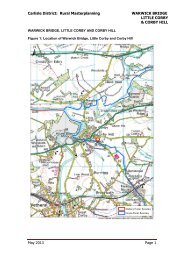
Great Corby & Geltsdale Ward – Castle Carrock; Great Corby; Heads Nook; Warwick<br />
Bridge.<br />
4.18 Part of the ward includes and Area of Outstanding Natural Beauty within which the greater<br />
part of Castle Carrock is situated. Sites of Scientifi c Interest (SSSI) can be found to the West<br />
of Great Corby and North West of Warwick Bridge. These are also within areas of fl ood plain.<br />
Ancient Woodlands lie to the North East of Great Corby.<br />
4.19 Warwick Bridge is the largest of the Local Service Centres within the ward (as the settlement<br />
includes Little Corby and Corby Hill which are situated within Hayton Ward) and is situated<br />
on the A69 Newcastle Road. Great Corby is designated as a Conservation Area. Heads<br />
Nook has the smallest range of services only having a Village Hall It is one of only two Local<br />
Service Centres within the district that do not have a Primary School. The other Service<br />
Centres benefi t a range of facilities including Primary Schools.<br />
4.20 Educational achievement at GCSE level within the ward is the highest in the District at 81.8%<br />
against District average of 49.6% (see table 2).<br />
Hayton Ward – Hayton<br />
4.21 There is a Primary School in Hayton along with other services.<br />
4.22 Life expectancy within the ward is the highest at 83.2 years in District and well above the<br />
Average of 77.4 years (see table 2).<br />
Irthing Ward – Gilsland; Hallbankgate.<br />
4.23 The Landscape within the Ward is designated as being of County Importance and it also<br />
contains several areas of Ancient Woodland. Hadrian’s Wall World Heritage Site runs across<br />
the ward with Gilsland being within the Hadrian’s Wall Buffer Zone.<br />
4.24 The Grade II Listed Lanercost Priory founded in c.1169 is within Irthing Ward.<br />
4.25 The ward abuts Northumberland with the Local Service Centre of Gilsland being split across<br />
the two Counties. It’s Primary School, Church and Public House are all within Irthing Ward.<br />
The area to the north of Gilsland is fl ood plain and contains a Site of Scientifi c Importance.<br />
4.26 Hallbankgate to the south of the ward is fragmented, and benefi ts from a range of services<br />
including a Primary School.<br />
Page 20
Longtown & Rockcliffe Ward – Longtown (KSC) Rockcliffe<br />
4.27 The Ward is to the East of the District which goes to the Solway Firth and as such fl ood<br />
plains are identifi ed in and around the Local Service Centre of Rockcliffe. Part of this area<br />
falls within the Solway Coast AONB.<br />
4.28 Rockcliffe has a range of facilities including a Primary School.<br />
4.29 Longtown is one of the District’s two <strong>Key</strong> Service Centres which are both within the Rural<br />
East area. It is surrounded by Urban Fringe Landscape and Flood Plain. The central core of<br />
Longtown is designated as a Conservation Area which takes in an area either side of the A7<br />
(Edinburgh Road) which runs through the town and where most of the retail facilities can be<br />
found. There is a good link road to the M6/M74.<br />
4.30 The secondary school in Longtown closed in 2008 and pupils now attend William Howard in<br />
Brampton.<br />
4.31 Longtown has several Industrial sites in and around its boundary of which haulage is a<br />
feature. The Auction Mart holds some of the largest sheep sales in the country<br />
4.32 The Ward has the lowest Life Expectancy of 76.3 years in the Rural Area (District Average<br />
77.4 years). It also has the lowest Educational achievement at GCSE level at 34.7% (District<br />
Average 49.6%) (see table 2).<br />
Lyne Ward – Smithfield<br />
4.33 Lyne ward is one of the largest by area and is to the north of the district bounding Scotland.<br />
Kershope Forest covers a large section of the ward.<br />
4.34 Smithfi eld is the only Local Service Centre in the ward and is a small compact village which<br />
benefi ts from a Primary School.<br />
Stanwix Rural Ward – Houghton; Irthington<br />
4.35 Hadrian’s Wall Heritage Site runs through this ward and through the Local Service Centre of<br />
Houghton. The ward is adjacent to the urban area.<br />
4.36 Flood plains are situated to the East of Houghton. Around the village green it is a traditional<br />
village which was extended to the south in the late 1980’s. The village benefi ts from having a<br />
range of services including a Primary School.<br />
4.37 <strong>Carlisle</strong> Airport, adjacent to the A689, is within the ward. The airport has been subject<br />
to recent planning permissions for potential development. Adjacent sites offer sites for<br />
employment use.<br />
4.38 Irthington is the Local Service Centre close to <strong>Carlisle</strong> Airport and is within the Hadrian’s Wall<br />
Buffer Zone. The village benefi ts from having a range of services including a Primary School.<br />
A fl ood plain lies to the East of the Village.<br />
Page 21
Wetheral Ward – Cumwhinton; Scotby; Wetheral<br />
4.39 Wetheral Ward is to the East of the urban area but separated by the M6. The <strong>Carlisle</strong> Settle<br />
Conservation area runs through the ward via Scotby and Cumwhinton. The original village of<br />
Wetheral is designated a conservation area and includes the railway viaduct over the River<br />
Eden.<br />
4.40 The landscape to the south east of Wetheral is identifi ed as a Landscape of County<br />
Importance; the River Eden SSSI/SAC also fl ows through Wetheral. Hadrian’s Wall Heritage<br />
Site Buffer Zone runs along the A69 to the north of Scotby. Flood plains have been identifi ed<br />
around Scotby and Wetheral.<br />
4.41 Wetheral along with Heads Nook in Great Corby & Geltsdale Ward does not have a Primary<br />
School. Pupils attend the Primary School at Scotby. Wetheral however does have a Railway<br />
Station (<strong>Carlisle</strong> - Newcastle Line). Cumwhinton also has its own Primary School and all<br />
three have a range of facilities.<br />
4.42 Wetheral Ward has the lowest Claimant Rate at 0.9% (District Average 2.8%). It also has<br />
the lowest deprivation score in the Rural Area of 9.21% (District Average 22.7% highest<br />
being 23.61% in Longtown & Rockcliffe Ward) (see table 2 below).<br />
Table 2<br />
Life<br />
Expectancy<br />
yrs<br />
Brampton<br />
Great<br />
Corby &<br />
Geltsdale<br />
Hayton Irthington Longtown<br />
& Rockliffe<br />
Lyne<br />
Stanwix<br />
Rural<br />
Wetheral<br />
District<br />
77.7 80.8 83.2 79.1 76.3 79.7 79.4 81.2 77.4<br />
Claimant 3.2 1 1.6 1.2 1.7 1 1 0.9 2.8<br />
Rate %<br />
Deprivation % 17.96 12.34 14.53 16.66 23.61 18.91 11.83 9.21 22.7<br />
5 GCSE’s @ 50 81.8 41.2 60 34.7 45.5 55.1 79.6 49.6<br />
A* - C %<br />
Population 4,479 2,073 2,015 2,008 4,156 2,072 4,417 4,505<br />
Source: Cumbria Observatory Nov 2010.<br />
Barriers to 6071 653 2449 167 3253 119 1200 243<br />
Housing<br />
Services<br />
Deprivation<br />
Index of Multiple Deprivation Ranking fi gures 1 – 7969 (1 is most deprived) Source: <strong>Carlisle</strong> Rural Profi le Dec 2007<br />
Page 22
<strong>Carlisle</strong> Rural West<br />
4.43 This area encompasses the smaller part of <strong>Carlisle</strong>’s rural district having an area of approx<br />
140 sq km and a population of around 8,000 (approx 25% of the rural population). The<br />
composition of the area is generally classed as “Less Sparse” as defi ned under Urban/Rural<br />
Defi nitions by Census Output Area for the <strong>Carlisle</strong> Area [source <strong>Carlisle</strong> Rural Profi le Dec<br />
2007]. Agriculture features highly within the ward.<br />
4.44 Rural West is made up of 2 Wards and does not contain contains any <strong>Key</strong> Service Centres.<br />
Within these Wards there are 6 of the District’s 20 Local Service Centres these are listed<br />
together below:<br />
Burgh Ward – Burgh-by-Sands; Great Orton; Thurstonfield<br />
4.45 Burgh Ward is adjacent to the South West boundary of the Urban Area. The Northern<br />
boundary of the ward is the Solway Firth and the area around the Firth is identifi ed as being a<br />
fl ood plain and as an area of Outstanding Natural Beauty. The <strong>Key</strong> Service Centre of Burghby-Sands<br />
falls within this area. Hadrian’s Wall Heritage Site runs through Burgh-by-Sands.<br />
4.46 All three Local Service Centres have a Primary School and additional local services.<br />
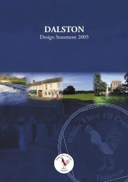
Dalston Ward – Cummersdale; Dalston; Raughton Head<br />
4.47 Dalston Ward is adjacent to the southern boundary of the Urban Area. The Ward has two<br />
major factories: Steads at Cummersdale and Nestle at Dalston. Dalston village is the largest<br />
Local Service Centre within the District.<br />
4.48 The River Caldew runs through the ward and fl ood plains are identifi ed along it. The centre of<br />
Dalston is designated as a Conservation area.<br />
4.49 All three Local Service Centres have a Primary School. Dalston has the greatest range<br />
of facilities including a variety of shops around the village square, a railway station and a<br />
secondary school.<br />
Table 3<br />
Burgh Dalston District<br />
Life Expectancy<br />
yrs 81.2 77.1 77.4<br />
Claimant Rate % 1.6 1.4 2.8<br />
Deprivation % 12.79 14.67 22.7<br />
5 GCSE’s @ A* - C % 55.6 64.2 49.6<br />
Population 2,030 6,192<br />
Source: Cumbria Observatory<br />
Nov 2010.<br />
Barriers to Housing Services<br />
684 1710<br />
Deprivation<br />
Index of Multiple Deprivation Ranking fi gures 1 – 7969 (1 is most deprived) Source: <strong>Carlisle</strong> Rural Profi le Dec 2007<br />
Page 23
Page 24
Chapter 5 Scope of the Core Strategy<br />
5.1 The scope of the Core Strategy will be very wide and is intended to provide a spatial vision for<br />
<strong>Carlisle</strong> until 2030. The concept of sustainable development must underlie the whole of the<br />
Core Strategy and a sustainability appraisal (currently being prepared) will have an important<br />
role to play.<br />
5.2 Below under the three headings social, economic and environmental are the key issues for<br />
<strong>Carlisle</strong> that we have so far identifi ed that we feel are important and should be addressed in<br />
the Core Strategy:<br />
Social<br />
• Lack of suffi cient housing appropriate for aging population.<br />
• Insuffi cient affordable housing distribution in the rural area.<br />
• Presence of poor quality housing<br />
• Reduction in the level of house building due to the economic downturn.<br />
• Lack of larger housing in the parts of the rural area<br />
• Lack of social rented family housing<br />
• Strain on support services particularly in the rural area<br />
• Inequalities in health across the District<br />
• Meeting the needs of an aging population<br />
• Outmigration of young professionals<br />
• Restricted housing supply in the rural area, implications for affordability and community cohesion<br />
Economic<br />
• Poor skills in the wider rural area with poor connections to <strong>Carlisle</strong> and transport routes<br />
• Perception of remoteness, poor accessibility<br />
• Poor performance in education<br />
• Low take up of post 16 education, low aspirations<br />
• Imbalance in the distribution of employment sites throughout <strong>Carlisle</strong><br />
• Low quality employment sites<br />
• Diffi culty in maintaining the sustainability of rural communities<br />
• High levels of employment in lower paid sectors, higher paid sectors under represented.<br />
• <strong>Carlisle</strong> has a small population which coupled with the other economic issues identifi ed result in<br />
low economic potential for the District<br />
• Under-exploited tourism potential, no professional theatre and lack of high quality hotel<br />
• Under-representation of business sectors with potential for growth<br />
• Too great a reliance on low productivity sectors<br />
• Limited high speed broadband access, particularly in the rural area.<br />
Environmental<br />
• High levels of CO2 linked to congested transport routes<br />
• Variations in access to open space due to lack of provision in some wards<br />
• Meeting future energy needs, reducing reliance on non renewable sources of fuel/energy<br />
• High dependency on private car usage for short and longer journeys<br />
• Flood risk poses a constraint to development in certain parts of the District.<br />
• Potential threat to areas of nature conservation due to increased development pressures<br />
• Meeting aspirations for sustainable levels of growth through economic development whilst<br />
minimising potential environmental implications<br />
Page 25
Page 26
Appendix 1<br />
National<br />
National Planning Policy Statements (PPS) / Planning Policy Guidance Notes (PPG) and Circulars<br />
National Policy Statements Planning and Compulsory Purchase Act 2004 Planning Act 2008<br />
Regional<br />
Draft Cumbria Landscape Character Guidance and Toolkit 2010.<br />
Future for the North West (formerly Regional Strategy 2010)<br />
North West Regional Economic Strategy (2006)<br />
North West Sustainable Energy Strategy (2006)<br />
Regional Spatial Strategy Partial Review Consultation (2009)<br />
The North West Plan: Regional Spatial Strategy to 2021 (2008)<br />
Sub Regional<br />
Cumbria Agreement (Local Area Agreement 2008 - 2011)<br />
Cumbria Biodiversity Action Plan (2001)<br />
Cumbria Climate Change Strategy and Cumbria Climate Change Action Plan (2009-2014)<br />
Cumbria Economic Strategy 2009 - 2019 (2009)<br />
Cumbria Employment Land and Floorspace Assessment (2006)<br />
Cumbria Gypsy and Traveller Accommodation Needs Assessment Final Report 2008 Cumbria<br />
Historic Character Assessment (2009)<br />
Cumbria and Lake District Joint Structure Plan 2001 - 2016 (2006)<br />
Cumbria Landscape Character Guidance and Toolkit 2010 (draft July 2010)<br />
Cumbria Local Transport Plan 2 (2005/06 - 2011/12)<br />
Cumbria Mineral and Waste Development Framework (2009 - onwards)<br />
Cumbria Strategic Housing Market Assessment (2009)<br />
Cumbria Sustainable Community Strategy 2008 - 2028<br />
Cumbria Sub-Regional Action Plan 2009 - 2012 (2009)<br />
Cumbria Sub-Regional Employment Sites (SRES) Study (2008)<br />
Cumbria Economic Strategy, Cumbria Vision (February 2009)<br />
Local<br />
A Community Plan for <strong>Carlisle</strong> - Report and Update 2008<br />
<strong>Carlisle</strong> Employment Sites Study: Implications for M6 Corridor (June 2010)<br />
<strong>Carlisle</strong> Growth Point Programme of Development 2008.<br />
<strong>Carlisle</strong> Open Space, Sports and Recreation Facilities Audit 2005<br />
<strong>Carlisle</strong> Renaissance Development Framework and Movement Strategy - Baseline Report and<br />
Final Document (January 2007)<br />
<strong>Carlisle</strong> Renaissance Development Framework and Movement Strategy - Policy Statement<br />
(January 2007)<br />
<strong>Carlisle</strong> Retail Capacity Forecasts Update 2009 (DTZ) (Previous ones were: March 2000 (CB<br />
Hillier Parker) and <strong>Carlisle</strong> Retail Study Update 2006 (Donaldsons)).<br />
<strong>Carlisle</strong> Sector Review (2007)<br />
<strong>Carlisle</strong> Renaissance: Economic Strategy SWOT Analysis (2006)<br />
Draft Strategic Housing Land Availability Assessment 2010<br />
Growing <strong>Carlisle</strong>: An Economic Strategy for the <strong>Carlisle</strong> <strong>City</strong> Region (March 2008)<br />
M6 Corridor - Employment Sites Baseline Review (2009)<br />
Page 27
South <strong>Carlisle</strong> Development Access Study (2008)<br />
Urban Design Guide & Public Realm Framework (2008)<br />
<strong>Carlisle</strong> <strong>City</strong> <strong>Council</strong> Climate Change Strategy 2008-1012<br />
Studies currently being prepared<br />
Strategic Flood Risk Assessment - due March 2011<br />
Cumbria Renewable and Low Carbon Energy Capacity and Deployment Study - due May 2011<br />
<strong>Carlisle</strong> Strategic Housing Land Availability Assessment (November 2010 consultation draft)<br />
<strong>Carlisle</strong> Green Infrastructure Strategy (due for preparation following completion of the SFRA)<br />
<strong>Carlisle</strong> <strong>City</strong> <strong>Council</strong> Annual Monitoring Report (December 2010)<br />
Page 28
Page 29