Georges Heights - Part 1 - Sydney Harbour Federation Trust
Georges Heights - Part 1 - Sydney Harbour Federation Trust
Georges Heights - Part 1 - Sydney Harbour Federation Trust

You also want an ePaper? Increase the reach of your titles
YUMPU automatically turns print PDFs into web optimized ePapers that Google loves.
<strong>Sydney</strong> <strong>Harbour</strong> <strong>Federation</strong> <strong>Trust</strong><br />
Management Plan - Mosman No.8<br />
<strong>Georges</strong> <strong>Heights</strong><br />
5 December 2008
Copyright © <strong>Sydney</strong> <strong>Harbour</strong> <strong>Federation</strong> <strong>Trust</strong> 2008.<br />
This work is copyright. Apart from any use as permitted<br />
under the Copyright Act 1968, no part may be<br />
reproduced by any process without written permission<br />
from the <strong>Sydney</strong> <strong>Harbour</strong> <strong>Federation</strong> <strong>Trust</strong>. Requests<br />
and enquiries concerning reproduction and rights should<br />
be addressed to the Director Communications, <strong>Sydney</strong><br />
<strong>Harbour</strong> <strong>Federation</strong> <strong>Trust</strong> PO Box 607, Mosman, NSW<br />
2088 or email to info@harbourtrust.gov.au<br />
For more information about the <strong>Sydney</strong> <strong>Harbour</strong><br />
<strong>Federation</strong> <strong>Trust</strong> or to view this publication online, visit<br />
the website at: http://www.harbourtrust.gov.au
Table of Contents<br />
Introduction ....................................................................................................................... 5<br />
Aims of this Plan...............................................................................................................6<br />
Planning Framework ........................................................................................................ 7<br />
RELATIONSHIP WITH THE TRUST’S COMPREHENSIVE PLAN .....................................7<br />
RELATIONSHIP WITH OTHER TRUST MANAGEMENT PLANS ......................................7<br />
RELATED TRUST POLICIES AND GUIDELINES..........................................................7<br />
RELATIONSHIP WITH THE HEADLAND PARK DESIGN FRAMEWORK ...........................8<br />
STATUTORY PLANNING CONTEXT .......................................................................11<br />
NON STATUTORY PLANNING STRATEGIES ...........................................................12<br />
PLANS PREPARED FOR NEIGHBOURING LANDS....................................................13<br />
Site Description............................................................................................................... 15<br />
Site History ...................................................................................................................... 16<br />
Analysis and Assessment ............................................................................................. 24<br />
HERITAGE LISTINGS...........................................................................................24<br />
CONSERVATION MANAGEMENT PLANS ................................................................24<br />
ARCHAEOLOGICAL ASSESSMENTS......................................................................25<br />
CULTURAL LANDSCAPE .....................................................................................25<br />
NATURAL VALUES .............................................................................................26<br />
PHYTOPHTHORA CINNAMOMI...............................................................................28<br />
BUSHFIRE RISK .................................................................................................29<br />
STORMWATER ...................................................................................................29<br />
SITE CONTAMINATION ........................................................................................30<br />
HAZARDOUS MATERIALS....................................................................................33<br />
SERVICES .........................................................................................................33<br />
COMPLIANCE WITH THE BUILDING CODE OF AUSTRALIA .......................................33<br />
TRANSPORT MANAGEMENT ................................................................................33<br />
TRAFFIC, PARKING AND ACCESS ........................................................................34<br />
Heritage Values ............................................................................................................... 35<br />
SUMMARY STATEMENT OF SIGNIFICANCE ............................................................35<br />
COMMONWEALTH HERITAGE VALUES..................................................................36<br />
CONDITION OF VALUES ......................................................................................38<br />
MANAGEMENT REQUIREMENTS AND GOALS.........................................................40<br />
CONSERVATION POLICIES ..................................................................................40<br />
Outcomes......................................................................................................................... 49<br />
INTEGRATION WITH SURROUNDING LANDS...........................................................49<br />
DESIGN OF THE PUBLIC DOMAIN .........................................................................50<br />
ACCESS AND CIRCULATION ................................................................................52<br />
DESIGN AND ADAPTIVE RE-USE OF BUILDINGS ....................................................53<br />
WATER SENSITIVE URBAN DESIGN .....................................................................54
PHYTOPHTHORA CINNAMOMI...............................................................................55<br />
REMEDIATION....................................................................................................56<br />
INTERPRETATION ...............................................................................................57<br />
Implementation ............................................................................................................... 57<br />
MONITORING AND REVIEW OF THE PLAN..............................................................60<br />
Acknowledgements: Images ......................................................................................... 61<br />
Appendices......................................................................................................................64<br />
APPENDIX 1 - SCHEDULE 7A ..............................................................................64<br />
APPENDIX 2 – SCHEDULE 7B .............................................................................66<br />
APPENDIX 3 ......................................................................................................67
Introduction<br />
On 21 st August 2003 the Minister for the Environment and Heritage approved a<br />
Comprehensive Plan for the seven harbour sites managed by the <strong>Sydney</strong> <strong>Harbour</strong><br />
<strong>Federation</strong> <strong>Trust</strong>. The plan, which was prepared in accordance with the requirements of<br />
the <strong>Sydney</strong> <strong>Harbour</strong> <strong>Federation</strong> <strong>Trust</strong> Act 2001, sets out the <strong>Trust</strong>’s vision for the<br />
harbour sites under its control.<br />
A requirement of the <strong>Trust</strong>’s Comprehensive Plan is that more detailed management<br />
plans are prepared for specific precincts, places or buildings. In addition to this, the<br />
Environment Protection and Biodiversity Conservation (EPBC) Act 1999 also requires<br />
the <strong>Trust</strong> to make plans to protect and manage the Commonwealth Heritage values of<br />
Commonwealth Heritage Places that it owns. The <strong>Georges</strong> <strong>Heights</strong> precinct is identified<br />
on the Commonwealth Heritage List as one of these places.<br />
Accordingly, the purpose of this Management Plan is to guide the outcomes proposed in<br />
the <strong>Trust</strong>’s Comprehensive Plan and to satisfy the requirements of Schedule 7A of the<br />
EPBC Regulations, 2000 and to be consistent with the Commonwealth Heritage<br />
management principles.<br />
The Comprehensive Plan proposes the creation of a Headland Park that integrates<br />
Middle Head, <strong>Georges</strong> <strong>Heights</strong> and Chowder Bay. The Headland Park will unify all of<br />
the elements along the Middle Head ridgeline, from Rawson Park to Middle Head.<br />
The vision for the park is a place where the area’s rich natural and cultural heritage,<br />
including its early aboriginal and military occupation, will be protected and interpreted<br />
and where access will be provided to areas that have long been inaccessible to most<br />
people.<br />
The <strong>Trust</strong> has identified the creation of the Headland Park as one of its highest priorities.<br />
Its goals are to ensure that:<br />
• The natural and cultural assets of Middle Head, <strong>Georges</strong> <strong>Heights</strong> and Chowder<br />
Bay are conserved;<br />
• The bushland area is increased in size;<br />
• A network of walking tracks is created that links the various former military<br />
precincts and other places of interest; and<br />
• Existing facilities are adaptively reused for appropriate educational, community,<br />
recreational and commercial uses.<br />
The <strong>Georges</strong> <strong>Heights</strong> precinct forms a key part of the unification of elements along the<br />
ridgeline. The key proposals include the provision of series of linked walks, landscaping<br />
to frame and improve views, improvements to drainage conditions and downslope<br />
bushland, reduction in the visual prominence of amenities block at the Oval, and<br />
facilitation of the adaptive re-use of the precinct buildings and structures for appropriate<br />
uses. In doing so, pedestrian connections with Bradley Bushland Reserve, Rawson<br />
Park and the Headland Park as a whole will be improved to maximise public access.<br />
The <strong>Sydney</strong> <strong>Harbour</strong> <strong>Federation</strong> <strong>Trust</strong> is committed to the conservation of the<br />
Commonwealth Heritage values of its places, and this commitment is reflected in its Act,<br />
5
its corporate planning documents and processes. This Management Plan, which<br />
satisfies sections 341V of the EPBC Act 1999, provides the framework and basis for the<br />
conservation and management of <strong>Georges</strong> <strong>Heights</strong> in recognition of its heritage values.<br />
The <strong>Trust</strong>’s Heritage Strategy, which details the <strong>Trust</strong>’s objectives and strategic<br />
approach for the conservation of heritage values, was prepared under section 341ZA of<br />
the EPBC Act 1999 and accepted by the Minister. The policies in this plan support the<br />
directions of the Heritage Strategy, and indicate the objectives for identification,<br />
protection, conservation, presentation and transmission to all generations of the<br />
Commonwealth Heritage values of the place.<br />
Commencement Date<br />
This plan was adopted by the <strong>Trust</strong> on 5 December 2008.<br />
Land to which the Management Plan Applies<br />
The land covered by the Management Plan is shown by broken black edging on the plan<br />
at Figure 1. All of the land is included within Lot 202 DP 1022020 and is in the<br />
ownership of the <strong>Sydney</strong> <strong>Harbour</strong> <strong>Federation</strong> <strong>Trust</strong>.<br />
The outcomes section of the plan (see Figure 12) also includes the adjoining lands,<br />
Rawson Park and Bradley Bushland Reserve, which are outside of the <strong>Trust</strong>’s<br />
ownership. These lands are under the care, control and management of Mosman<br />
Municipal Council.<br />
Although Mosman Council has an existing management framework for these lands,<br />
Rawson Park and Surrounds, Plan of Management, October 2001, the <strong>Trust</strong> has<br />
developed a concept masterplan for this area which will assist Council with guidance on<br />
the integration of these areas to form a unified parkland experience and transition<br />
between the spaces.<br />
Aims of this Plan<br />
The aim of this Management Plan is to:<br />
• Conserve, protect and interpret the Commonwealth Heritage values of <strong>Georges</strong><br />
<strong>Heights</strong> as an historic place on <strong>Sydney</strong> <strong>Harbour</strong>;<br />
• Be consistent with Commonwealth Heritage management principles;<br />
• Maximise public access;<br />
• Facilitate the adaptive re-use of the precincts’ buildings and structures for<br />
appropriate uses; and<br />
• Integrate the precinct with adjoining lands as part of a unified Headland Park.<br />
In doing this it also aims to:<br />
• Conserve and interpret the whole site as an historic precinct;<br />
• Regenerate and expand the bushland so that the sense of a ‘green’ gateway to<br />
<strong>Sydney</strong> <strong>Harbour</strong> is reinforced;<br />
• Enhance views to and from the precinct;<br />
• Realise the potential for easy access including access for the disabled;<br />
• Provide visitor facilities and amenities including parking and walking tracks;<br />
6
R O A<br />
M I D D L E<br />
C R A N E C R E S C E N T<br />
C L O S E<br />
H E A D<br />
M A R K H A M<br />
BRADLEY<br />
BUSHLAND<br />
RAWSON<br />
PARK<br />
GEORGES<br />
HEIGHTS<br />
OVAL<br />
Oval<br />
Amenities<br />
Building<br />
B E S T A V E N U E<br />
91<br />
92<br />
D O M I N I O N C R E S E C E N T<br />
Building 32 (North)<br />
Building 32 (South)<br />
S U A K I N D R I V E<br />
Existing Buildings And Structures<br />
91. Cottage, No. 1009 Dominion Crescent (c1950).<br />
92. Cottage, No. 1008 Dominion Crescent (c1950).<br />
97. Cottage No. 7 Imperial Place (c1986-1990).<br />
98. Cottage No. 5 Imperial Place (c1986-1990).<br />
99. Cottage No. 3 Imperial Place (c1986-1990).<br />
100. Cottage No. 1 Imperial Place (c1986-1990).<br />
101. Cottage No. 4 Imperial Place (c1986-1990).<br />
102. Cottage No. 2 Imperial Place (c1986-1990).<br />
103. Former Commanding Officers Residence, No. 6<br />
Commonwealth Avenue. (c1935).<br />
104. Navy Cottage, No. 7 Commonweath<br />
Avenue. (c1951-1952).<br />
Oil Tanks 3-5. WWII Camourflaged Fuel Tanks (c1942)<br />
SYDNEY HARBOUR<br />
NATIONAL PARK<br />
Commando<br />
Training<br />
Tower<br />
OIL<br />
TANK<br />
3<br />
OIL<br />
TANK<br />
4<br />
OIL<br />
TANK<br />
5<br />
97<br />
98<br />
99 100<br />
I M P E R I A L P L A C E<br />
101 102<br />
103<br />
C O M M O N W E A L T H<br />
104<br />
A V E.<br />
GUNSHOT ALLEY<br />
Management Plan Boundary<br />
Master Plan Boundary<br />
Fig.01 5 Management Park Design Plan Concept Area <strong>Georges</strong> Chowder <strong>Heights</strong> Bay<br />
N<br />
0 20 40 60 80 100m
• Provide opportunities and site interpretation for visitors to understand and<br />
appreciate the totality of the site’s heritage;<br />
• Remediate site contamination and hazardous materials;<br />
• Encourage uses and activities that promote the use of sustainable modes of<br />
transport and ensure that traffic generated by the site’s re-use has a minimal<br />
impact on the surrounding residential areas;<br />
• Protect adjacent bushland from the spread of Phytophthora cinnamomi;<br />
• Improve the quality of stormwater runoff; and<br />
• Apply the principles of Ecologically Sustainable Development (ESD).<br />
Planning Framework<br />
Relationship with the <strong>Trust</strong>’s Comprehensive Plan<br />
This Management Plan is the middle level of a three tiered comprehensive planning<br />
system developed to guide the future of the <strong>Trust</strong>’s lands.<br />
The other levels are:<br />
• The <strong>Trust</strong>’s Comprehensive Plan - this is an overarching plan that provides a<br />
process for the preparation of Management Plans; and<br />
• Specific projects or actions - actions are defined in the Commonwealth<br />
Environment Protection and Biodiversity Conservation Act 1999 (EPBC Act) and<br />
are similar to the concept of development in NSW planning legislation.<br />
This Management Plan must be interpreted in conjunction with the <strong>Trust</strong>’s<br />
Comprehensive Plan, in particular the Outcomes identified in <strong>Part</strong> 7 of the <strong>Trust</strong>’s<br />
Comprehensive Plan and the Objectives and Policies in <strong>Part</strong> 3.<br />
The Outcomes diagram in <strong>Part</strong> 7 of the <strong>Trust</strong>’s Comprehensive Plan for <strong>Georges</strong><br />
<strong>Heights</strong> is reproduced at Figure 2. Conservation policies in this plan provide guidance<br />
on how these outcomes can be managed in a way that protects, conserves, presents<br />
and transmits to all generations the Commonwealth Heritage values.<br />
The Objectives and Policies most relevant to this Management Plan are those relating to<br />
access, open space and recreation, bush care, the conservation of cultural and<br />
Aboriginal heritage and of the natural environment, sporting facilities, the adaptive reuse<br />
of buildings, water quality and catchment protection, bushfire management, and<br />
contamination. These Objectives and Policies were addressed during the assessment<br />
of the site and are discussed in more detail in the relevant sections of this plan.<br />
Relationship with other <strong>Trust</strong> Management Plans<br />
This Management Plan is the eighth to be prepared by the <strong>Trust</strong> for land within the<br />
Mosman Local Government Area. All of the Management Plans must be consistent with<br />
each other as well as any other plans for neighbouring lands.<br />
Related <strong>Trust</strong> Policies and Guidelines<br />
There are a number of overarching Policies and Guidelines foreshadowed in the <strong>Trust</strong>’s<br />
Comprehensive Plan that will be developed over the lifetime of the <strong>Trust</strong> and that will<br />
also guide the conservation, adaptive reuse and development of the Headland Park.<br />
7
Current relevant policies are:<br />
• The <strong>Trust</strong>’s Leasing of Land and Buildings policy;<br />
• The <strong>Trust</strong>’s Policy for the Leasing of Land and Buildings to Community Users;<br />
• The <strong>Trust</strong>’s Event Policy;<br />
• The <strong>Trust</strong>’s Heritage Strategy;<br />
• The <strong>Trust</strong>’s draft Phytophthora Root-Rot Management Strategy and Best<br />
Practice Procedures for Bush Regeneration Activities; and<br />
• The <strong>Trust</strong>’s Headland Park Interpretation Strategy.<br />
This Management Plan has had regard for these existing polices. If or when other <strong>Trust</strong><br />
Policies and Guidelines are developed this plan will be reviewed to ensure that they do<br />
not impact adversely on the Commonwealth heritage values.<br />
Relationship with the Headland Park Design Framework<br />
There are six former Defence bases at Middle Head, <strong>Georges</strong> <strong>Heights</strong> and Chowder<br />
Bay. The transformation of these bases into a unified area of parkland requires<br />
consideration of all of the elements that make up the public domain. It also needs to<br />
satisfy expectations about public access to and enjoyment of the site, the conservation<br />
of its natural and cultural heritage and its integration with the harbour, the foreshore and<br />
the local neighbourhood.<br />
The development of the design framework and the design treatment of each of its<br />
elements will be drawn from the heritage values and characteristics of the lands, rather<br />
than imposing an arbitrary new “design statement”.<br />
The design framework for the Headland Park is shown at Figure 3. It identifies all of the<br />
elements that make up the public domain, how they need to work together as a network<br />
of spaces and the principles that will guide their detailed design development within each<br />
of the Management Plan areas.<br />
The elements of the public domain comprise:<br />
• Precincts – areas with distinct characteristics by virtue of land uses or physical<br />
factors such as topography, building scale and form;<br />
• Streets and Paths – the network of routes that provide access to and through the<br />
site for all modes – walking, cycling, public transport and private motor vehicles;<br />
• Entries - to a precinct or significant public places;<br />
• Significant Public Places – the destinations, the spaces used for gatherings,<br />
relaxation, ceremony or cultural or sporting activity;<br />
• Landmarks – places, structures or natural features of public interest; and<br />
• Edges – the boundaries between precincts, the borders to parks and gardens,<br />
dramatic level changes, the interfaces between buildings and the public domain.<br />
Precincts<br />
The terrain and its relationship to the harbour is the first and most fundamental<br />
consideration for all of these elements. It is the terrain that has given rise to the historic<br />
uses and it is its relationship to the harbour that makes these lands special.<br />
The early fortifications located at the escarpment and the associated defence facilities<br />
on the knolls form identifiable precincts. These precincts include –<br />
8
Provide pedestrian link through HMAS<br />
Penguin and protect integrity of Angophora<br />
forest<br />
Investigate potential water access<br />
COBBLERS BEACH<br />
BALMORAL BEACH<br />
HMAS<br />
Penguin<br />
Middle<br />
Head<br />
Oval<br />
<strong>Sydney</strong> <strong>Harbour</strong><br />
National Park<br />
MIDDLE HEAD<br />
TO MANLY<br />
Form continuous parkland<br />
to envelop 10 Terminal and<br />
Former School of Pacific<br />
Administration<br />
HMAS<br />
Penguin<br />
OBELISK BAY<br />
LEGEND<br />
Existing vegetation<br />
Proposed planting<br />
Grassed area<br />
Adjacent vegetation<br />
Extend bushland. Create sense of arrival to<br />
Headland Park<br />
Existing building<br />
Building retention to be reviewed<br />
Building to be removed<br />
30 Terminal - orientation/picnic area<br />
understanding the major themes of the<br />
Headland Park<br />
New replacement buildings<br />
possible in this area<br />
subject to design guidelines<br />
Rawson<br />
Park<br />
Ease slopes, improve drainage and plant<br />
trees around <strong>Georges</strong> <strong>Heights</strong> Oval<br />
Markham Close Housing<br />
- Sale subject to Plan of<br />
Management<br />
Create continuity of<br />
parkland through 1st<br />
Commando Company<br />
Headquarters<br />
<strong>Georges</strong><br />
<strong>Heights</strong><br />
Oval<br />
Middle Head Rd<br />
GEORGES<br />
HEIGHTS<br />
<strong>Sydney</strong> <strong>Harbour</strong><br />
National Park<br />
Chowder Bay Rd<br />
SHFT boundary<br />
Former shoreline<br />
Training Command/WWI hospital - bring<br />
bushland to the edges of the building<br />
cluster<br />
Extend hillside bushland, create sense of<br />
arrival<br />
GEORGES HEAD<br />
Main pedestrian route<br />
<strong>Georges</strong> <strong>Heights</strong><br />
Precinct<br />
8th Brigade Drill Hall, Cross Street -<br />
Potential sports facilities and bush<br />
regeneration<br />
Bush regeneration around<br />
Camouflaged Fuel Tanks<br />
The <strong>Trust</strong> lands will form part of a great headland park<br />
A place to experience the wonder of the land and water<br />
Natural bush and clean water, a place of respite in the city<br />
A place to learn about the natural and cultural history of <strong>Sydney</strong><br />
A place to enjoy outdoor recreation, including sporting activities<br />
Potential water access<br />
at Chowder Bay and<br />
water based activities<br />
TO TARONGA ZOO<br />
CHOWDER<br />
BAY<br />
Naval re-fuelling facilities<br />
to be retained and<br />
continue operations<br />
Bushland will be enhanced and regenerated and drainage<br />
improved to provide viable flora and fauna habitat and protect rich<br />
aquatic habitat. More than double the area of bushland on <strong>Trust</strong><br />
land.<br />
A network of paths will be part of a great harbour foreshore walk<br />
from North Head to Taronga Zoo revealing a succession of<br />
dramatic views.<br />
Conservation and interpretation requires adaptive re-use as<br />
facilities and activities to compliment and enrich the experience of<br />
visiting the headland park. The totality of the heritage will be<br />
conveyed, including Defence and the Aboriginal heritage.<br />
CLIFTON<br />
- GARDENS<br />
-<br />
<strong>Sydney</strong> <strong>Harbour</strong><br />
National Park<br />
Some buildings that have low heritage value will be demolished<br />
Fig.02<br />
The <strong>Trust</strong>'s Comprehensive Plan - OUTCOMES<br />
Middle Head, <strong>Georges</strong> <strong>Heights</strong>, Chowder Bay<br />
N<br />
CHOWDER HEAD
LEGEND<br />
Forts<br />
Outlook<br />
Parking<br />
Continuous Path<br />
easy access<br />
Able bodied path<br />
Minor path<br />
Accessible Picnic<br />
Significant Places<br />
Road<br />
Rock Ledges<br />
Links with<br />
surrounding path<br />
network to be<br />
investigated and<br />
implemented with<br />
NPWS and<br />
Mosman Council<br />
Fig.03<br />
Headland Park - DESIGN FRAMEWORK<br />
<strong>Georges</strong> <strong>Heights</strong><br />
N
• The Mosman Drill Hall and its parkland setting adjoining Rawson Park;<br />
• The former World War I Hospital precinct on the highest knoll at <strong>Georges</strong><br />
<strong>Heights</strong>;<br />
• The former Gunners’ Barracks (Officers’ Mess) and fortifications at <strong>Georges</strong><br />
Head;<br />
• The fortifications, sheds and barrack buildings at the spur terminating the<br />
<strong>Georges</strong> <strong>Heights</strong> plateau, before the ridge drops to Middle Head;<br />
• The Middle Head barracks; and<br />
• The cluster of buildings at Chowder Bay.<br />
Generally, these precincts have an institutional - parkland character, with the buildings<br />
forming small-scale, civic spaces.<br />
The open spaces on the saddles of the undulating plateau and the steep slopes also<br />
create distinct precincts. These include:<br />
• The steep, wooded slopes below the escarpment;<br />
• The plateau which is generally characterised by coastal heath and exposed rock<br />
ledges; and<br />
• The institutional parkland areas of the former bases.<br />
The Headland Park will form a succession of spaces from hill tops with a sense of<br />
openness and height above all the surrounding land – such as at the cairn at Rawson<br />
Park, through to more enclosed areas in the saddles and valleys and to places along<br />
escarpment edges. As the plateau narrows and winds towards the headland, these<br />
spatial experiences will vary – as the views into Middle <strong>Harbour</strong> unfold and gain equal<br />
prominence to the views to the outer harbour and the ocean.<br />
The <strong>Georges</strong> <strong>Heights</strong> precinct sits at the highest point of the Headland Park. Its height<br />
and location provide commanding views of the surrounding parklands and harbour. The<br />
precinct is comprised of a series of distinct nodes: the Park entrance at its peak, the<br />
open character of the Oval, the bushland setting of the tanks exaggerating their<br />
presence, and the suburban feel of the residences. Maintaining this character will be a<br />
central consideration in the planning for the site. These elements will be knitted together<br />
through the linking of the pedestrian networks and landscape treatments.<br />
This plan addresses these distinct nodes within the precinct and their re-integration with<br />
one another and as a continuous experience within the Headland Park as a whole. This<br />
is discussed further in the Outcomes section.<br />
Streets and Paths<br />
The access network needs to provide clear and convenient access to and through the<br />
Headland Park. Each of the elements of the network will be designed to reflect its role<br />
and function, and the desire to create an unfolding sequence of experiences in response<br />
to the environment it passes through. The network consists of the following elements,<br />
as shown in Figure 3:<br />
• The approach roads adjoining and leading into the park – Middle Head Road,<br />
Chowder Bay Road and Suakin Drive;<br />
• Internal streets and laneways within each precinct (within the former bases);<br />
9
• A major pathway circuit that provides access for people with all levels of mobility<br />
and that links the significant public places, features and landmarks, the entry<br />
roads, car parks and local neighbourhood;<br />
• A minor pathway network providing more variety, intimacy and seclusion, and<br />
access for able-bodied walkers to limited areas within the bushland; and<br />
• The car parks and bus set down areas.<br />
<strong>Part</strong> of the <strong>Georges</strong> <strong>Heights</strong> precinct is located on the path of the former Military<br />
Reserve Road which connected Cross Street Drill Hall site to Training Command. The<br />
original route has been interpreted in the <strong>Trust</strong>’s design approach by using it as a<br />
pathway which connects the site to the Rawson Park cairn and the Headland Park entry<br />
on to Suakin Drive.<br />
As a general principle cycling should not take place on walking paths, however cycling<br />
will be encouraged where it is safe and appropriate. To facilitate this, the <strong>Trust</strong> will<br />
consider designating some paths as shared pathways and providing a link with Mosman<br />
Council’s bicycle path through Rawson Park which connects Balmoral Beach with Athol<br />
Wharf.<br />
Entries<br />
It is proposed that there will be numerous “Entry Points” in the Headland Park so that<br />
access opportunities are maximised and dispersed. This will accommodate people<br />
arriving from many different directions and by different modes of travel and will avoid<br />
concentrations of visitors.<br />
Entries in the public domain will not usually be built structures. Rather, they will be<br />
spaces that serve as an entry and do not need to be given strong emphasis.<br />
Significant Public Places<br />
The Headland Park will have a range of public spaces offering a diversity of activities.<br />
These will include:<br />
• Passive recreational areas for picnics and social relaxation;<br />
• Areas for community sporting activities;<br />
• Places of contemplation within a bushland setting or on the escarpment with<br />
spectacular views; and<br />
• Small civic spaces defined by former defence buildings for community gatherings<br />
or simply watching the passers by.<br />
They will form a series of experiences connected by the main pathway network. All of<br />
these spaces are located and chosen to enhance an understanding and appreciation of<br />
the natural environment and the succession of historical uses.<br />
The significant public places at <strong>Georges</strong> <strong>Heights</strong> include the sports oval, the site of the<br />
former 1 Commando Headquarters and the Camouflaged Fuel Tanks.<br />
Landmarks<br />
Within each of the precincts, there are significant features that relate to the history or the<br />
natural beauty of the place. They are often beautiful or unusual structures, buildings or<br />
natural features that provide the focus in public places or points of interest along the<br />
10
way. The setting of these features will be designed to assist in a greater understanding<br />
and appreciation of their significance and the Headland Park as a whole.<br />
The site of the former 1 Commando Headquarters provides an excellent opportunity as a<br />
local focal point to highlight the exceptional views from the ridgeline.<br />
The Camouflaged Fuel Tanks are also a focal point and significant landmark of the<br />
precinct. Opportunities exist for their conservation and adaptive reuse, and for their<br />
bushland setting to be preserved and enhanced.<br />
Edges<br />
The precinct has distinct edges in part formed by its interface with the <strong>Sydney</strong> <strong>Harbour</strong><br />
National Park and residences in Markham Close. Other edges are less defined and<br />
form the basis of creating a continuous experience though the parkland.<br />
With respect to the <strong>Sydney</strong> <strong>Harbour</strong> National Park, the primary consideration is the<br />
protection and improvement of the downslope bushland conditions by effective<br />
stormwater management and bush regeneration around the edges. The <strong>Trust</strong> will work<br />
together with National Parks & Wildlife Service to achieve this.<br />
The concept masterplan for the area (see Figure 12) makes recommendations that will<br />
reinforce the relationship with adjoining lands.<br />
The treatment of the edge adjoining residences in Markham Close must take into<br />
consideration any potential amenity impacts.<br />
Statutory Planning Context<br />
Commonwealth Legislation<br />
All ‘actions’ on <strong>Trust</strong> land, undertaken by either the <strong>Trust</strong> or on behalf of the <strong>Trust</strong>, are<br />
controlled by the Environment Protection and Biodiversity Conservation (EPBC) Act.<br />
Section 26 of the EPBC Act protects all aspects of the environment on <strong>Trust</strong> land from<br />
actions taken either on the <strong>Trust</strong>’s land or on adjoining land that may have a significant<br />
impact on it, while Section 28 protects the environment from any actions of the <strong>Trust</strong> or<br />
any other Commonwealth agency that may have a significant impact.<br />
The environment is defined to include:<br />
(a) ecosystems and their constituent parts, including people and communities; and<br />
(b) natural and physical resources; and<br />
(c) the qualities and characteristics of locations, places and areas; and<br />
(d) heritage values of places; and<br />
(e) the social, economic and cultural aspects of the matters mentioned in (a), (b)<br />
or (c) above<br />
Section 341ZC of the EPBC Act requires the <strong>Trust</strong> to have regard for the<br />
Commonwealth Heritage values of a place before it or any other Commonwealth agency<br />
takes an action. A Commonwealth agency must not take an action if there is a potential<br />
11
adverse impact on the Commonwealth Heritage values, unless there is no feasible or<br />
prudent alternative. If there is no feasible or prudent alternative, the Commonwealth<br />
agency must take all measures to mitigate the impact. The Commonwealth Heritage<br />
Values section of this Plan describes the values of the site.<br />
State Legislation<br />
The <strong>Sydney</strong> <strong>Harbour</strong> <strong>Federation</strong> <strong>Trust</strong> Act, 2001 specifically excludes any land owned<br />
by the <strong>Trust</strong> from the operations of state planning law. This includes State Policies<br />
(SEPPs) and Regional Environmental Plans (REPs) prepared by the State Government<br />
and Local Environmental Plans (LEPs) prepared by councils.<br />
Notwithstanding this the <strong>Trust</strong> has prepared this plan so that it is consistent with both<br />
State and local plans. The relevant statutory plans are:<br />
<strong>Sydney</strong> Regional Environmental Plan (<strong>Sydney</strong> <strong>Harbour</strong> Catchment) 2005<br />
This SREP applies to the whole of <strong>Sydney</strong> <strong>Harbour</strong>’s waterways, the foreshores and<br />
entire harbour catchment. It provides a framework for future planning, development and<br />
management of the waterway, heritage items, islands, wetland protection areas and<br />
foreshores of <strong>Sydney</strong> <strong>Harbour</strong>. Under the SREP, the <strong>Georges</strong> <strong>Heights</strong> precinct is<br />
included in the catchment area of <strong>Sydney</strong> <strong>Harbour</strong>. The planning principles of the SREP<br />
relevant to the site include:<br />
• The protection, maintenance and enhancement the natural assets and unique<br />
environmental and visual qualities of <strong>Sydney</strong> <strong>Harbour</strong> and its foreshores;<br />
• <strong>Sydney</strong> <strong>Harbour</strong> and its foreshores should be recognised and protected as<br />
places of exceptional heritage significance;<br />
• The role of <strong>Sydney</strong> <strong>Harbour</strong> in the history of Aboriginal and European settlement<br />
should be appreciated;<br />
• The natural, scenic, environmental and cultural qualities of the Foreshores and<br />
Waterways Area should be protected; and<br />
• Archaeological sites and places of Aboriginal heritage significance should be<br />
conserved.<br />
Mosman Local Environmental Plan 1998<br />
The <strong>Georges</strong> <strong>Heights</strong> precinct is located within the Mosman Local Government Area. As<br />
the <strong>Georges</strong> <strong>Heights</strong> precinct is a ‘deferred matter’ under Mosman LEP 1998, Mosman<br />
LEP No.1, 1982, continues to apply. Under LEP No.1, 1982, the site is zoned for<br />
‘Special Uses – Military Reserve’.<br />
Non Statutory Planning Strategies<br />
Sharing <strong>Sydney</strong> <strong>Harbour</strong> Access Plan<br />
The Sharing <strong>Sydney</strong> <strong>Harbour</strong> Access Plan (SSHAP) identifies a network of new and<br />
improved public access ways for pedestrians and cyclists, and waterway facilities for<br />
recreational watercraft.<br />
The SSHAP identifies <strong>Georges</strong> <strong>Heights</strong> as being a ‘Place of Cultural Interest’ and as part<br />
of the existing network of walking tracks. Mosman Council has received funding under<br />
the plan to provide a cycleway linking Taronga Zoo Wharf with Balmoral Beach. The<br />
12
proposed route of this cycleway passes through Rawson Park and in close proximity to<br />
the <strong>Georges</strong> <strong>Heights</strong> precinct. It is proposed that existing and proposed pathways<br />
provide interconnecting links into these established networks.<br />
Mosman Bicycle Strategy 2005-2010<br />
In 2005 Mosman Council adopted a bicycle strategy which outlines bicycle related<br />
initiatives for the next 5 years. It covers major infrastructure projects, bicycle parking,<br />
education and signage.<br />
The strategy identifies future on-road and off-road cycling paths linking <strong>Georges</strong> <strong>Heights</strong><br />
with the rest of Council’s cycling network.<br />
Plans Prepared for Neighbouring Lands<br />
Plans and policies prepared by neighbouring land managers provide a context for this<br />
Management Plan. The following are particularly relevant.<br />
<strong>Sydney</strong> <strong>Harbour</strong> National Park Plan of Management<br />
The <strong>Georges</strong> <strong>Heights</strong> precinct adjoins the <strong>Sydney</strong> <strong>Harbour</strong> National Park. The National<br />
Parks and Wildlife Service (NPWS) have prepared a Plan of Management that applies to<br />
the whole of the <strong>Sydney</strong> <strong>Harbour</strong> National Park including Middle Head and <strong>Georges</strong><br />
Head.<br />
The Plan of Management outlines general and specific objectives for the National Park<br />
with the overall strategy for the Park being the protection, and where necessary,<br />
restoration of the Park’s natural vegetation, and the maintenance and adaptive reuse of<br />
important historic places.<br />
The Park is divided into precincts with emphasis to be given to the following strategies in<br />
the <strong>Georges</strong> <strong>Heights</strong> Precinct:<br />
• Interpretation of defence history; and<br />
• Rehabilitation of the natural vegetation.<br />
High priority projects that have been achieved to date and that are relevant to the <strong>Trust</strong>’s<br />
Headland Park include the preparation of a weed control program, feral animal<br />
management at Middle Head, the preparation of a fire management plan and the<br />
construction of tracks.<br />
Plan of Management for Rawson Park and Surrounds, 2001<br />
In 2001 Mosman Council commissioned Gutteridge Haskins and Davey Pty Ltd to<br />
prepare a Plan of Management for Rawson Park and Surrounds. This plan covers<br />
Rawson Park, land up to and including Bradley Bushland and the existing grassed<br />
netball courts.<br />
The Rawson Park Plan of Management recognises the need to successfully combine the<br />
varied recreational and community uses with the opportunity to appreciate the<br />
environmental, cultural and historic values of the park. Community consultation<br />
established that major changes in the management and use of the park were<br />
undesirable and that future uses should be determined in accordance with the heritage<br />
significance of Rawson Park.<br />
13
The plan contains the following management objectives that are relevant to the <strong>Georges</strong><br />
<strong>Heights</strong> plan:<br />
• Provide a high quality recreation resource which offers opportunities for a wide<br />
range of uses and activities without detrimentally impacting on other values;<br />
• Maintain, protect and enhance the natural environment with regard to appropriate<br />
ecological principles including improving the quality and integrity of the Bradley<br />
Bushland Reserve;<br />
• Consider Rawson Park and Surrounds in the context of its connection to<br />
adjoining bushland areas and reserves;<br />
• Ensure adequate protection, enhancement and appropriate use of significant<br />
heritage items and recognise and increase community awareness of the history<br />
of Rawson Park and the Bradley Bushland Reserve;<br />
• Protect and enhance the Park’s scenic quality and maintain its open and scenic<br />
character; and<br />
• Provide a framework for appropriate management which enhances and<br />
maintains the character and values of the Park.<br />
Plans made under the Rural Fires Act 1997<br />
There are two sub-plans of the NSW State Bush Fire Plan made under the Rural Fires<br />
Act 1997 that apply to the Mosman local government area, including the <strong>Harbour</strong> <strong>Trust</strong>’s<br />
land and the adjoining <strong>Sydney</strong> <strong>Harbour</strong> National Park. The Manly - Mosman District<br />
Bush Fire Management Plan 2000 deals with strategies to minimise bush fire risk such<br />
as hazard reduction. The Manly - Mosman Bush Fire Operations Plan 2003 deals with<br />
the operational and management issues. Evacuation routes are determined under Local<br />
Emergency Disaster Plans.<br />
The NSW National Parks and Wildlife Service has prepared a Fire Management Plan<br />
(FMP) for <strong>Sydney</strong> <strong>Harbour</strong> and Botany Bay National Parks. The aims of the FMP<br />
include the protection of life and property, coordination of fire management with other<br />
agencies, and management of fire regimes.<br />
There is also a Bush Fire Prone Land Map prepared under Section 146(2) of the<br />
Environmental Planning and Assessment Act 1979 (EP&A Act) that was approved by the<br />
NSW Rural Fire Service in 2003. This map identifies the majority of the site as a<br />
vegetation buffer zone. <strong>Part</strong>icular developments proposed on bush fire prone lands can<br />
trigger the need to conform to the requirements of Planning for Bushfire Protection 2001<br />
guidelines under the EP&A Act.<br />
The <strong>Trust</strong> has completed an assessment of bushfire risk for its sites at Middle Head,<br />
<strong>Georges</strong> <strong>Heights</strong> and Chowder Bay and this assessment informed the preparation of this<br />
management plan. The <strong>Trust</strong> will also cooperate with other agencies in the<br />
implementation of plans prepared under the Rural Fires Act 1997.<br />
14
Site Description<br />
The <strong>Georges</strong> <strong>Heights</strong> precinct is approximately 9.1 hectares in area and is located on<br />
the ridge of Middle Head, one of the three headlands that define the entrance to <strong>Sydney</strong><br />
<strong>Harbour</strong>. The site sits directly upslope from Chowder Bay on an undulating plateau<br />
providing a number of natural vantage points with excellent views of <strong>Sydney</strong> and Middle<br />
<strong>Harbour</strong>s.<br />
The site contains the <strong>Georges</strong> <strong>Heights</strong> Oval, the former 1 Commando Headquarters site,<br />
the WWII Camouflage Fuel Tanks, and ten defence houses – see Figure 1.<br />
Suakin Drive provides the main vehicular access to the site via Middle Head Road. A<br />
walking track linking Rawson Park to the <strong>Georges</strong> <strong>Heights</strong> Oval currently provides<br />
pedestrian access from the direction of Mosman town centre.<br />
Bushland exists along the southwest and southeast edges of the site where the<br />
topography falls down to the National Park, to Chowder Bay and to the harbour beyond.<br />
This surrounding vegetation acts to significantly screen the site from the harbour and<br />
forms an impressive bushland backdrop to the land.<br />
Where the topography falls to the north lie the residences of Markham Close. Bradley<br />
Bushland Reserve forms the western boundary to this residential area.<br />
The former 1 Commando site provides a direct link between Rawson Park located to the<br />
west and <strong>Georges</strong> <strong>Heights</strong> Oval to the east.<br />
<strong>Georges</strong> <strong>Heights</strong> Oval sits at the northern end of the site on the ridgetop. The site<br />
consists of a full sized oval accommodating two cricket pitches and an amenities block<br />
with some minimal shaded seating in front. The area is currently used formally for<br />
cricket, winter sports such as soccer, rugby and athletics and local community and<br />
school uses. The oval is also used for overflow parking for large community events.<br />
The former 1 Commando Headquarters was demolished in March 2006 and a cleared<br />
one hectare site was created in preparation for landscaping on the ridge of Middle Head<br />
directly to the west of the oval. The site sits directly upslope from Chowder Bay and is<br />
positioned at the western end of Dominion Crescent, which provides the only vehicular<br />
access to this part of the site. The entry gates to the former Commandos site remain as<br />
the only evidence of its former use. A mound has been created to the northern edge of<br />
this site to create a landscape buffer and screen to the residential properties at Markham<br />
Close. A southern mound has also been created which will provide an elevated position<br />
to capture wider views along the ridgeline and across the harbour. The site is currently<br />
enclosed by chain link fencing creating a division between the Oval and Rawson Park<br />
accesses. Two residences exist just outside the fenced area and now that the 1<br />
Commando buildings have been removed the residences on Dominion Crescent remain<br />
relatively isolated.<br />
Southeast of the former 1 Commando Headquarters site lies the largest structure within<br />
the precinct, the WWII Camouflaged Fuel Tanks, comprising three tanks which were<br />
used as reserves to the steel tanks at Chowder Bay. Each tank has an independent<br />
15
pitched roof which was part of the camouflage strategy during WWII. The boundary of<br />
the Camouflaged Fuel Tanks is presently marked out with chain wire fencing,<br />
surrounded by remnant bushland, separating the site from the defence houses on<br />
Commonwealth Avenue and from the access road of Dominion Crescent.<br />
Comprising of eight defence houses set in bushland surroundings, Imperial Place and<br />
Commonwealth Avenue represent a unique element in the Headland Park with their<br />
suburban characteristics. These houses are currently rented for residential purposes.<br />
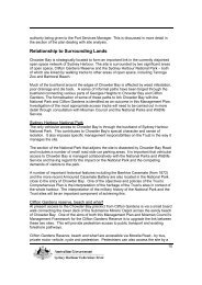
Surrounding Lands<br />
The site is in a central position within the Headland Park, and as such will form one of<br />
the key links with the other precincts and will provide entry points for pedestrians and<br />
cyclists from the neighbouring areas outside of the <strong>Trust</strong>’s lands.<br />
Areas of bushland adjoin the former 1 Commando site to the south (<strong>Sydney</strong> <strong>Harbour</strong><br />
National Park), and extending south and east to Chowder Bay, and to the west (Council<br />
managed Bradley Bushland). This ridge top bushland is a closed scrub vegetation<br />
community dominated by Allocasuarina distyla and Banksia integrifolia species. There is<br />
a moderate level of weed infestation in the ground layer dominated by asparagus fern<br />
and lantana. Overall the bushland is in reasonable condition, with previously cleared<br />
areas (fire break) beginning to regenerate.<br />
Rawson Park, to the west of <strong>Georges</strong> <strong>Heights</strong>, contains popular local sporting facilities.<br />
The key features of the Park are its sports oval and spectator pavilion; six lawn netball<br />
training courts, which will be moved to the Drill Hall site; the Scotland-Australia cairn;<br />
and a 37-space car park with vehicular access via Cross Street. This area also provides<br />
a popular off-leash dog walking area.<br />
Site History<br />
Aboriginal Heritage<br />
In 2004, the <strong>Trust</strong> engaged the Australian Museum to undertake a survey to identify<br />
Aboriginal archaeological sites and any associated issues related to Aboriginal heritage<br />
for six sites at Middle Head, including the <strong>Georges</strong> <strong>Heights</strong> Precinct. The Museum<br />
concluded that the site has no known archaeological significance for the area’s original<br />
inhabitants, the Borogegal clan although it is of moderate archaeological sensitivity.<br />
Notwithstanding this, the site is important for the role it played in an attempt by Governor<br />
Macquarie to encourage Aborigines to engage in farming and to adapt to the European<br />
way of living. In 1815 Macquarie reported to London that he had succeeded in getting<br />
16 adult Aborigines to settle on a small farm on the north side of the harbour. The<br />
families were given implements and clothing and convicts were appointed to teach them<br />
how to farm.<br />
These aboriginal settlers were not members of the local Borogegal clan, they were from<br />
the Broken Bay area and Macquarie appointed one of them, Bungaree, “to be their chief”<br />
(Figure 4). Bungaree has been described as witty, intelligent and something of a<br />
diplomat and is recognized as an example of significant collaboration between<br />
Aboriginals and Europeans. Macquarie and Bungaree were to become firm friends and<br />
16
at the ceremony to mark the establishment of the farm Macquarie presented Bungaree<br />
with a metal gorget (breast plate) inscribed “Chief of Broken Bay Tribe.”<br />
Figure 4: King Bungaree, Chief of the<br />
Broken Bay Tribe, died 1832. Hand<br />
coloured lithograph drawn by C. Rodius,<br />
from life in 1831 and on stone in 1834.<br />
The exact boundaries of the farm are uncertain. However, in 1815 the <strong>Sydney</strong> Gazette<br />
described it as being situated on “the peninsula of <strong>Georges</strong> Head, being nearly<br />
surrounded on all sides by the sea.” In Thomas Florance’s Survey of Port Jackson<br />
(1828) this showed the farm’s location as being in the Middle Head area.<br />
In 2004 the <strong>Trust</strong> engaged historian, Rosemary Kerr, to undertake further documentary<br />
research to try and determine a more precise location of Bungaree’s Farm.<br />
Documentary searches to date have not revealed the location of the farm.<br />
European Heritage<br />
Following the failure of Bungaree’s Farm, the area was left largely unoccupied until the<br />
1850s and the <strong>Georges</strong> <strong>Heights</strong> Precinct passed into private ownership. However, in<br />
1854 it was resumed by the Crown for military purposes and from then until 2006 was<br />
used for a variety of army purposes.<br />
The buildings and structures from the various phases of military occupation are shown in<br />
Figure 5.<br />
1871 to 1913 <strong>Harbour</strong> and Coastal Defences<br />
The decision in 1870 by the British Government to withdraw its troops from the<br />
Australian colonies and to pass defence responsibilities to the individual colonies<br />
resulted in the NSW government adopting an “outer line” of defence strategy for <strong>Sydney</strong><br />
17
<strong>Harbour</strong>. This consisted of a series of batteries on the outer reaches of the harbour<br />
including <strong>Georges</strong> Head, Middle Head, Bradley’s Head and inner South Head.<br />
Once the construction of batteries was in progress the planners’ attention was turned to<br />
the construction of permanent barracks. Within the <strong>Georges</strong> <strong>Heights</strong> precinct, during<br />
this initial building period, the Officers’ Quarters were constructed. This building was built<br />
on an excavated site now occupied by Building 103 and remained in this location until at<br />
least 1935. A description of these quarters in 1903 indicates that they were constructed<br />
in weatherboard, as sandstone had become less accessible and more expensive by this<br />
stage, and were provided with verandah, outhouses and stables. The excavated rock<br />
cutting made to accommodate the building is all of the physical evidence remaining of<br />
the building.<br />
During the initial period of the fort building at George’s Head in 1871-1876 a small spur<br />
road was constructed off the existing track to the site of the Gunner’s Barracks and<br />
batteries. The east-west section of Suakin Drive preserves the line of this spur road. At<br />
the same time a track was constructed off this new road to the site of the Officer’s<br />
Quarters. Commonwealth Avenue preserves the line of this track today. A roadway was<br />
also built to connect Bradleys Head Road to Middle Head, this later provided the link<br />
between the Training Command and the Mosman Drill Hall precinct.<br />
In 1902, Rawson Park which forms the western boundary of the <strong>Georges</strong> <strong>Heights</strong><br />
Precinct was officially opened by the Governor, Sir Henry Rawson as one of the first<br />
parks established in Mosman. It was not until the 1920s that Mosman Council built the<br />
oval and pavilion. Two croquet lawns were also built with the cost largely met by the<br />
members of the Mosman Croquet Club.<br />
1914 to 1938 WWI and Inter-war Construction<br />
During this time, the surrounding defence areas on the ridge were used largely for<br />
hospital purposes to serve the many casualties of WWI and by 1918, it was the home of<br />
the third largest military hospital in Australia (Figure 6). By 1922 the neighbouring<br />
hospital had been disbanded and the site put to other military uses such as a training<br />
centre for army personnel. At this time the <strong>Georges</strong> <strong>Heights</strong> precinct mainly comprised<br />
bushland with some clearings formed to provide connections with other parts of the<br />
Military Reserve.<br />
The established residential function of the eastern portion of the precinct’s, originally<br />
relating to its proximity to the batteries, continued. A large duplex residence was<br />
constructed as Married Quarters during the 1930’s on the north side of Imperial Place.<br />
However, demolition was scheduled in 1960, making way for the three smaller and more<br />
modern residences which remain today.<br />
By 1935 the former Officers’ Quarters had been demolished and replaced with the<br />
current, Building 103. Built for the Commanding Officer of the <strong>Georges</strong> <strong>Heights</strong><br />
Barracks, the residence has elements of Inter-war Art Deco style. The house reflects<br />
standards of officer accommodation during the inter-war period, and maintains the use of<br />
this part of the site for officer accommodation which began in the 1870s.<br />
18
R O A<br />
M I D D L E<br />
C R A N E C R E S C E N T<br />
C L O S E<br />
H E A D<br />
M A R K H A M<br />
BRADLEY<br />
BUSHLAND<br />
RAWSON<br />
PARK<br />
GEORGES<br />
HEIGHTS<br />
OVAL<br />
Oval<br />
Amenities<br />
Building<br />
B E S T A V E N U E<br />
91<br />
92<br />
D O M I N I O N C R E S E C E N T<br />
Building 32 (North)<br />
Building 32 (South)<br />
S U A K I N D R I V E<br />
MAJOR PHASES OF DEVELOPMENT<br />
1871-1913<br />
<strong>Harbour</strong> and Coastal Defences<br />
Former Buildings / Structures<br />
1914-1938<br />
WWI / Inter - War Construction<br />
Former Buildings / Structures<br />
Commando<br />
Training<br />
Tower<br />
OIL<br />
TANK<br />
3<br />
OIL<br />
TANK<br />
4<br />
OIL<br />
TANK<br />
5<br />
97<br />
98<br />
99 100<br />
I M P E R I A L P L A C E<br />
101 102<br />
C O M M O N W E A L T H<br />
A V E.<br />
GUNSHOT ALLEY<br />
1939-1945<br />
WWII Wartime Construction<br />
1946-Present<br />
Adapting to Peace - Post War<br />
Former Buildings / Structures<br />
SYDNEY HARBOUR<br />
NATIONAL PARK<br />
103<br />
104<br />
Management Plan Boundary<br />
Fig.05 5 Phases Park Design of Development Concept <strong>Georges</strong> Chowder <strong>Heights</strong> Bay<br />
N<br />
0 20 40 60 80 100m
Figure 6: Plan of the<br />
<strong>Georges</strong> <strong>Heights</strong><br />
Battery, 1918. This Plan<br />
shows the building<br />
footprint, rock excavation<br />
and location of the 1903<br />
Officer’s Quarters in<br />
relation to the Battery<br />
and Barracks at <strong>Georges</strong><br />
Head. Note the recently<br />
completed Military<br />
Hospital.<br />
1939 to 1945 WWII Supporting the RAN fleets<br />
During WWII, the Navy ordered a number of fuel oil storage tanks to cater for visiting<br />
fleets, the growing RAN and the ships commandeered from the Australian merchant<br />
navy. Pearl <strong>Harbour</strong> and the fall of Singapore made this project an immediate necessity<br />
as the threat to Australia became a real possibility and as <strong>Sydney</strong> became the Allied port<br />
for operations in the South Pacific. The site chosen at <strong>Georges</strong> <strong>Heights</strong> was the only<br />
clear area in the defence reserve that could easily connect with the existing facilities.<br />
The selected location had easy access from the roadway for their construction and the<br />
height above sea level may have also been important for speed of fuel delivery to<br />
vessels. The <strong>Georges</strong> <strong>Heights</strong> tanks were to be used for surplus fuel oil storage,<br />
supplementing the two steel tanks further downslope in Chowder Bay, built in 1936.<br />
The Navy engaged the Water, Sewerage and Drainage Board to build the tanks with<br />
construction commencing in March 1942. The selected location was first modified to<br />
19
form a cut terrace into the sandstone bedrock. This cut formed part of a bund which was<br />
completed by a concrete wall. The tanks were a standard Board design with additional<br />
reinforcement and were designed to act as reserves for the steel tanks that were already<br />
in use at Chowder Bay. Concrete was used because steel had become a scarce<br />
commodity (because of demand for military hardware). Security for the tanks was<br />
provided through a sentry box with a telephone to the lower installation and a man-proof<br />
fence.<br />
As the threat of aerial attack loomed, three independent asbestos roofs for camouflage<br />
were included in the design. They were indicative of the philosophy of Dakin, an<br />
academic from <strong>Sydney</strong> University (Head of Zoology School), and author of “The Art of<br />
Camouflage”.<br />
…‘that camouflage was essential, not optional to war, and that camouflage was not a<br />
decoration to be stuck on something afterwards’.<br />
Many artists were located at <strong>Georges</strong> <strong>Heights</strong> to work on camouflage patterns as part of<br />
the NSW Defence State Camouflage Committee. The Committee wanted the roofs to be<br />
pitched as low as possible to resemble those on the neighbouring barracks. They were<br />
completed in August 1942 (Figure 7).<br />
As the only remaining fuel oil storage tanks in Port Jackson with that style of<br />
camouflage, they represent <strong>Sydney</strong>’s port preparations immediately after the fall of<br />
Singapore and the urgent need for furnace oil to supply to the RAN and allied fleets<br />
refuelling there, as well as merchant navy vessels.<br />
Figure 7: View of the concrete<br />
oil storage tanks at <strong>Georges</strong><br />
<strong>Heights</strong> after completion of the<br />
camouflage roof 1942. It is not<br />
known if hanging camouflage<br />
was used on these tanks,<br />
however the roofs were painted<br />
with a dull paint to help them<br />
blend in to the surroundings, and<br />
the roof structures themselves<br />
were designed to make the tanks<br />
look like buildings rather than<br />
fuel tanks. The camouflage<br />
technique relies on the nearby<br />
barracks buildings for the deceit<br />
to work.<br />
20
1946 to present Utilising the Military Reserve<br />
After WWII, defence lands were used opportunistically to accommodate various uses.<br />
For example a number of houses were constructed to accommodate defence personnel.<br />
In 1951, the ‘Swedish Cottage’ located at the end of Commonwealth Avenue was<br />
constructed by the Navy to ensure adequate caretaking and ease of operation for the<br />
expanded Refuelling Depot. The cottage is an excellent example of the almost identical<br />
group of prefabricated cottages at Lower <strong>Georges</strong> <strong>Heights</strong> on Middle Head Road, which<br />
were manufactured by Åmåls Sågverks Aktiebolag (the Amal Sawmilling Company).<br />
The construction of these cottages were part of a large post-WWII importation project,<br />
where prefabricated houses and workmen to erect them were brought to Australia from<br />
Britain, Sweden, Finland, Norway, the Netherlands, Germany and Austria to cope with<br />
the severe shortage of housing, materials and labour that Australia was experiencing<br />
during this time (Figure 8).<br />
Figure 8: The former Navy<br />
Cottage is important in<br />
demonstrating the design of the<br />
Swedish Åmåls Sågverks<br />
Aktiebolag (ÅSA) prefabricated<br />
dwellings of the 1950s, which were<br />
imported by the Commonwealth to<br />
overcome shortages in labour and<br />
materials in the post war years.<br />
<strong>Georges</strong> <strong>Heights</strong> Oval, formerly known as ‘Army’ oval, was formed in 1955 and<br />
continues to be used by various sporting and community groups. The location of the<br />
oval had been previously cleared by the military and used to form part of the route of the<br />
old military road that connected Cross Street with Training Command. During the early<br />
1980s, the amenities building was built by Council to serve the oval (See Figure 9).<br />
When the navy decommissioned the concrete tanks in the 1960s, the neighbouring<br />
areas were freed up for additional defence housing in Imperial Place. This group of<br />
houses are typically constructed of face brickwork with terracotta tiled roofs. Each<br />
appears to be an individually designed project home adapted for Defence use. They are<br />
all modest in their scale and character and are similar to the former Defence housing at<br />
Markham Close and along Middle Head Road in Lower <strong>Georges</strong> <strong>Heights</strong>. The houses<br />
on the upper, northern side of the road appear to be from 1960, with the houses on the<br />
lower side dating from the 1970s to the 1980s. These houses remain tenanted and are<br />
leased out by the <strong>Trust</strong>.<br />
21
Figure 9: This photograph shows the construction of Rawson Oval in 1927 looking<br />
east towards the <strong>Georges</strong> <strong>Heights</strong> precinct. The former Hospital Buildings at<br />
Training Command are visible in the background and the cleared area in between<br />
would later become the location of <strong>Georges</strong> <strong>Heights</strong> Oval formed in 1955 and the 1<br />
Commandos site.<br />
In 1954 the Military Board decided to re-raise commando companies in both Victoria and<br />
NSW, as part of the Citizen Military Forces (CMF, now the Army Reserve). The<br />
headquarters of the <strong>Sydney</strong> Commando Company was originally located at Lower<br />
<strong>Georges</strong> <strong>Heights</strong>. Each unit was commanded by a major, and numbered up to 250<br />
soldiers.<br />
Later the 1 Commando Company moved headquarters to a site located at the western<br />
end of Dominion Crescent located between Rawson Park and <strong>Georges</strong> <strong>Heights</strong> Oval.<br />
This site contained a group of utilitarian two-storey brick offices, workshops, training hall,<br />
storage buildings and a vehicular garage arranged around the sides of a large flat<br />
asphalt yard area. Work began on these buildings in 1954, with the majority of buildings<br />
being completed by 1965. The two residences on Dominion Crescent were also built<br />
early in the 1950s and remain on the site today.<br />
The complex was used by the 1 Commando Company until 2006 for administration and<br />
accommodation purposes (see Figure 10). The area surrounding the base became<br />
some of the most challenging training areas found in <strong>Sydney</strong> and the recruits and their<br />
staff used the cliffs, bush, beaches and bays to train and hopefully earn their Green<br />
Berets. The gaining of this qualification was the result of a gruelling selection and<br />
training process over 12 months, and many applicants did not meet the challenge. The<br />
wooden structure which can be seen in the bushland downslope of Dominion Crescent<br />
today, was built by the Commandos to be used to teach abseiling from a helicopter.<br />
22
A portion of the adjoining Council managed Rawson Park was dedicated as the Bradley<br />
Bushland Reserve in 1982 to honour local residents Joan and Eileen Bradley for their<br />
pioneering work promoting the regeneration of native bushland.<br />
Figure 10: The former One Commando Company Headquarters buildings in 2005 prior to<br />
demolition.<br />
Defence Vacate<br />
During the early 1990s the Department of Defence determined that much of its land on<br />
<strong>Sydney</strong> <strong>Harbour</strong> was surplus to requirements. This led to great community concern, and<br />
the creation of the Headland Preservation Group, which in turn led to the formation of<br />
the Defenders of <strong>Sydney</strong> <strong>Harbour</strong> Foreshores Coalition in 1997 who lobbied for these<br />
sites to remain in public ownership and for their cultural heritage to be conserved. As a<br />
result, in 2001 the <strong>Sydney</strong> <strong>Harbour</strong> <strong>Federation</strong> <strong>Trust</strong> was established and the site<br />
transferred to the <strong>Trust</strong> to ensure its long term conservation and rehabilitation.<br />
At <strong>Georges</strong> <strong>Heights</strong>, 1 Commando Company remained in their headquarters site until<br />
2006, when they vacated and moved to HMAS Penguin. The <strong>Trust</strong> used this opportunity<br />
to remove the complex of buildings, a major barrier to the flow of the Headland Park, to<br />
facilitate improved connections with Rawson Park and provide a landscape buffer<br />
between the site and the residences at Markham Close. The brick gate posts remain and<br />
serve as a reminder of the several thousand young Australian men and women who<br />
passed through to serve Australia.<br />
23