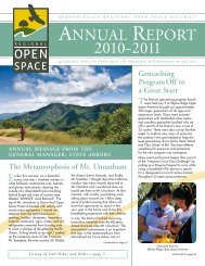
Layout 1 (Page 2) - Midpeninsula Regional Open Space District
Layout 1 (Page 2) - Midpeninsula Regional Open Space District
Layout 1 (Page 2) - Midpeninsula Regional Open Space District

Create successful ePaper yourself
Turn your PDF publications into a flip-book with our unique Google optimized e-Paper software.
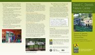
DANIELS NATURE CENTER<br />
Park at the Russian Ridge Preserve parking<br />
lot on the northwest corner of the Skyline<br />
Boulevard (Highway 35) and <strong>Page</strong> Mill/<br />
Alpine Road intersection (across Skyline Blvd.<br />
on the right). Walk to Alpine Pond at Skyline<br />
Ridge Preserve by going through the tunnel<br />
under Alpine Rd. The Nature Center is a<br />
small gray building on the east shore of<br />
Alpine Pond.<br />
EDGEWOOD COUNTY PARK<br />
From I-280, exit Edgewood Road. Drive 1<br />
mile on Edgewood Rd. toward San Carlos/<br />
Redwood City. Turn right into the park<br />
entrance (at Old Stagecoach Road).<br />
EL CORTE DE MADERA CREEK<br />
Meet at Skeggs Point, a Caltrans vista point<br />
on the east side of Skyline Boulevard, about<br />
4 miles north of La Honda Road (Highway<br />
84) and 1.5 miles south of Kings Mountain<br />
Road. Please note that Caltrans prohibits a<br />
left turn into the lot when approaching from<br />
the north along Skyline Blvd.<br />
FREMONT OLDER<br />
Meet at the Preserve parking lot on Prospect<br />
Road in Cupertino. Exit Highway 85 at De<br />
Anza Boulevard. (From northbound 85 turn<br />
left on De Anza Blvd. and from southbound<br />
85 turn right on De Anza Blvd.) Travel on De<br />
Anza Blvd. (toward the mountains) for about<br />
0.5 miles. Turn right on Prospect Rd. At the<br />
first stop sign, turn left and cross the railroad<br />
tracks to remain on Prospect Rd. Follow<br />
Prospect Rd. for 1.3 miles, turning left after<br />
the Saratoga Country Club, until you reach<br />
the Preserve parking lot.<br />
LONG RIDGE<br />
Meet at the Grizzly Flat trailhead on the west<br />
side of Skyline Boulevard 3.6 miles north of<br />
Highway 9, or 3.3 miles south of <strong>Page</strong> Mill<br />
Road. If you are coming from the north on<br />
Skyline Blvd., the pullout is just past Portola<br />
Heights Road on the right. From the south,<br />
the pullout is near the Palo Alto city limits<br />
sign on the right.<br />
LOS TRANCOS<br />
Meet at the Preserve parking lot on <strong>Page</strong><br />
Mill Road (across from Monte Bello Preserve),<br />
7 miles west of I-280 or 1.5 miles east of<br />
Skyline Boulevard. Those traveling from I-280<br />
on <strong>Page</strong> Mill Rd. should allow approximately<br />
35 minutes travel time.<br />
OUTDOOR ACTIVITIES • Summer 2011<br />
Where To Meet<br />
Directions to preserves featured in this season’s schedule of Outdoor Activities are listed below. Some preserves have more than one access point.<br />
Some activities meet at different locations than where the activity will actually occur. If an activity does not meet at the preserve listed, or if there<br />
is more than one preserve access point, the alternate meeting location will be indicated in italics on a separate line following the preserve name<br />
as part of the activity header. (For example: Skyline Ridge Meet: Russian Ridge or Russian Ridge Meet: Caltrans vista point). If no<br />
information follows the preserve name, then refer to the detailed directions for the preserve or alternate meeting location listed below.<br />
PLEASE CHECK THE LISTED DESCRIPTION TO MAKE SURE YOU MEET YOUR ACTIVITY LEADER AT THE CORRECT LOCATION.<br />
MONTE BELLO<br />
Meet at the Preserve parking lot on <strong>Page</strong><br />
Mill Road (across from Los Trancos Preserve),<br />
7 miles west of I-280 or 1.5 miles east of<br />
Skyline Boulevard. Those traveling from I-280<br />
on <strong>Page</strong> Mill Rd. should allow approximately<br />
35 minutes travel time.<br />
PICCHETTI RANCH<br />
From the intersection of I-280 and Foothill<br />
Expressway, go 3.5 miles southwest (toward<br />
the mountains) on Foothill Boulevard/Stevens<br />
Canyon Road. Turn right on Montebello<br />
Road. The Preserve is 0.5 miles up<br />
Montebello Rd. on the left.<br />
PULGAS RIDGE<br />
From I-280, exit Edgewood Road. Drive<br />
0.75 miles on Edgewood Rd. toward San<br />
Carlos/Redwood City. Turn left (north) on<br />
Crestview Drive, then immediately turn left on<br />
Edmonds Road. Follow Edmonds Rd. to the<br />
Preserve parking lot entrance on the right.<br />
PURISIMA CREEK REDWOODS<br />
Whittemore Gulch entrance: This entrance is<br />
on Skyline Boulevard next to the now closed<br />
Kings Mountain Country Store. The parking<br />
lot is 4.5 miles south of Highway 92, and<br />
8.1 miles north of Highway 84.<br />
Purisima Creek Road entrance: From the<br />
Highway 92 and Highway 1 intersection in<br />
Half Moon Bay, travel south on Highway 1<br />
approximately 4.3 miles. Turn left on Verde<br />
Road. After turning on Verde Rd. and traveling<br />
0.25 miles, continue straight to remain on<br />
what becomes Purisima Creek Road. (Verde<br />
Rd. splits off to the right.) Travel approximately<br />
3.7 miles on Purisima Creek Rd. to reach<br />
the Preserve.<br />
RANCHO SAN ANTONIO<br />
From I-280, take Foothill Boulevard south and<br />
turn right almost immediately onto Cristo Rey<br />
Drive. Continue about 1 mile, veer right around<br />
the traffic circle, and turn left into the park.<br />
Go to the lot farthest to the right and meet<br />
near the restroom at the bottom of the hill.<br />
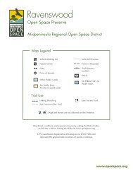
RUSSIAN RIDGE<br />
Meet at the Preserve parking lot on the<br />
northwest corner of the Skyline Boulevard<br />
(Highway 35) and <strong>Page</strong> Mill/Alpine Road<br />
intersection (across Skyline Blvd. on the right).<br />
Those traveling from I-280 on <strong>Page</strong> Mill Rd.<br />
should allow approximately 35 minutes<br />
travel time.<br />
6<br />
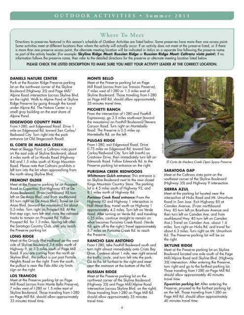
Jack Owicki<br />
El Corte de Madera Creek <strong>Open</strong> <strong>Space</strong> Preserve<br />
SARATOGA GAP<br />
Meet at the Caltrans vista point on the<br />
southeast corner of the Skyline Boulevard<br />
(Highway 35) and Highway 9 intersection.<br />
SIERRA AZUL<br />
Meet at the parking lot located near the<br />
intersection of Hicks Road and Mt. Umunhum<br />
Road in San Jose. Exit Highway 85 at<br />
Camden Avenue. (From northbound<br />
Hwy. 85 turn left on Branham Avenue and<br />
then turn left on Camden Ave. and from<br />
southbound Hwy. 85 turn left on Camden<br />
Ave.) Travel on Camden Ave. about 1.6<br />
miles. Turn right on Hicks Rd. and travel for<br />
about 6.3 miles. Turn right on Mt. Umunhum<br />
Rd. The Preserve parking lot will be on<br />
the right.<br />
SKYLINE RIDGE<br />
Meet at the Preserve parking lot on Skyline<br />
Boulevard located one mile south of the <strong>Page</strong><br />
Mill/Alpine Road and Skyline Blvd. (Highway<br />
35) intersection. After entering the Preserve,<br />
turn right and go to the farthest parking lot.<br />
Those traveling from I-280 on <strong>Page</strong> Mill Rd.<br />
should allow approximately 40 minutes<br />
travel time.<br />
Equestrian parking lot: After entering the<br />
Preserve, proceed to the farthest parking lot<br />
on the left. Those traveling from I-280 on<br />
<strong>Page</strong> Mill Rd. should allow approximately<br />
40 minutes travel time.